
Seeg
| coat of arms | Germany map | |
|---|---|---|

|
Coordinates: 47 ° 39 ' N , 10 ° 37' E |
|
| Basic data | ||
| State : | Bavaria | |
| Administrative region : | Swabia | |
| County : | Ostallgäu | |
| Management Community : | Seeg | |
| Height : | 853 m above sea level NHN | |
| Area : | 50.07 km 2 | |
| Residents: | 2997 (Dec. 31, 2019) | |
| Population density : | 60 inhabitants per km 2 | |
| Postal code : | 87637 | |
| Area code : | 08364 | |
| License plate : | OAL, FÜS, MOD | |
| Community key : | 09 7 77 170 | |
| Community structure: | 49 parts of the community | |
| Address of the municipal administration: |
Main street 39 87637 Seeg |
|
| Website : | ||
| Mayor : | Markus Berktold ( Voting Association "Zukunft Seeg" ) | |
| Location of the municipality of Seeg in the Ostallgäu district | ||
  |
||


The climatic health resort Seeg is a municipality in the Swabian district of Ostallgäu and the seat of the Seeg administrative community .
geography

Seeg is located in the Allgäu region . The landscape around Seeg is hilly with extensive pastures, moors and many small to medium-sized lakes. The two Seeger lakes and the Schwaltenweiher are among the most famous . The altitude of the community is 783 m (confluence of the Lengenwanger Mühlbach in the Lobach) to 1018 m above sea level (at the Senkelekopf).
The municipality has 49 officially named municipal parts (the type of settlement is given in brackets ):
|
|
The following districts exist: Seeg, Enzenstetten, Hack, Langegg, Osterwald and Senkelewald.
- Seeg district with Albatsried, Biedings, Buchach, Burk, Engelbolz, Greit, Hitzleried, Hochstraß, Hörmatzen, Kirchthal, Laich, Lobach, Lobacherviehweide, Obermühle, Ried, Riedegg, Schnarren, Schwalten, Seeg, Seeweiler, Sulzberg and Wiesleuten;
- District and former tax municipality Langegg with Beichelstein (former tax municipality Seeg, but today's district Langegg), Brandstatt, Goimenen, Gsöllen, Hebern, Langegg, Roßfallen, Senkele and Unterhalden;
- District and former municipality of Enzenstetten with Amberg, Anwanden, Aufmberg, Bach, Berkmühle, Dederles, Enzenstetten, Felben, Hollen, Oberreuten, Rennbothen, Schwarzenbach, Schweingg, Straß, Tannenmühle, Unterreuten and Zeil;
- District and former Hack exclave.
Enzenstetten was an independent municipality until March 31, 1971. Until then, Hack was an exclave of the Seeg community. Langegg was a tax municipality before the municipality was formed . Osterwald and Senkelewald were formerly unregulated areas and are uninhabited.
history
Until the church is planted
Seeg was first mentioned in a document between 1138 and 1147. The Ministeriale Suuiker de Seekka attested a document in Weihenstephan . The spelling for Seeg changed over the centuries: Seege, Seegi, Seeche, Secke, Seigg, Sögke.
Seeg belonged to the Hochstift Augsburg , which maintained its own office within the Füssen Care Department. With the Reichsdeputationshauptschluss of 1803, the place came to Bavaria. In 1818 the community was founded.
20th century
In 1958 Seeg was the resort recognized in December 1987, the municipality was awarded the predicate health resort.
Incorporations
On April 1, 1971, the previously independent municipality of Enzenstetten was incorporated and expanded the municipality of Seeg to the south-west.
On January 1, 1977 the community-free area Senkelewald was dissolved. The largest part came to the municipality of Seeg and expanded it to the east (today the Senkelewald district within the municipality of Seeg), and the rest went to the municipality and district of Roßhaupten bordering to the east .
On January 1, 1981, the community-free area Osterwald was dissolved. The majority with 506.79 hectares came to the municipality of Seeg and expanded it to the northeast (today the district of Osterwald within the municipality of Seeg), and the remainder went to the communities of Lengenwang and Marktoberdorf bordering to the north (there to the district of Sulzschneid ).
Population development
- 1970: 2318 inhabitants
- 1987: 2276 inhabitants
- 1991: 2652 inhabitants
- 1995: 2752 inhabitants
- 2000: 2811 inhabitants
- 2005: 2850 inhabitants
- 2010: 2804 inhabitants
- 2015: 2923 inhabitants
Seeg grew from 1988 to 2008 by 482 inhabitants or approx. 21%. Between 1988 and 2018 the municipality grew from 2346 to 2989 by 643 inhabitants or by 27.4%.
politics
mayor
Markus Berktold has been the mayor since 2014. It was set up by the voting community "Zukunft Seeg".
coat of arms
The coat of arms description reads: In red a silver sailing boat. The coat of arms was developed by Helga Lenkeit in 1950.
Culture and sights
The St. Ulrich church on the western edge of Seeg is one of the most important Rococo churches in Bavaria. The church, known as the “little Wies ” and consecrated in 1725, was designed by Johann Jakob Herkomer and furnished with frescoes and paintings by Balthasar Riepp and Johann Baptist Enderle . The last extensive renovation took place under Pastor Alois Meisburger (died 2007) in the years 2004 to 2007 with the support of the State of Bavaria, the German Foundation for Monument Protection and private donations.
With the Burgstall Burk there is a former aristocratic residence in the municipality, which is a vivid example of a high medieval tower hill castle in Bavaria.
Economy and Infrastructure
Economy including agriculture and forestry
According to official statistics, there were ten employees at the place of work in the field of agriculture and forestry, 238 in manufacturing and 37 in trade and transport. In other economic sectors 192 people were employed at the place of work subject to social security contributions. There were a total of 851 employees at the place of residence subject to social security contributions. There were nine companies in the manufacturing sector and four in the construction sector. In addition, there were 150 farms in 1999 with an agriculturally used area of 3351 ha, of which 3348 ha were permanent green space.
traffic
The Seeg stop is on the Biessenhofen – Füssen railway line . There are connections to Augsburg and Munich.
education
In 1999 the following institutions existed:
- a kindergarten with 125 places and 115 children
- a primary school with twelve teachers and 250 students
photos
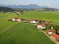
Enzenstetten from above

Trinity Chapel in Enzenstetten

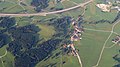
Kirchthal from above

Spring at Seeg

Seeg from above

Seeger lakes
Sea dwelling


Personalities
- Irene Epple-Waigel (* 1957), ski racer, wife of Theo Waigel
- Maria Epple-Beck (* 1959), ski racer
Web links
- Entry on Seeg's coat of arms in the database of the House of Bavarian History
- Interesting things from history and people by Theodor Frey, etc. a. to the Church of St. Ulrich
- Seeg: Official statistics of the LfStat (PDF; 1.05 MB)
Individual evidence
- ↑ "Data 2" sheet, Statistical Report A1200C 202041 Population of the municipalities, districts and administrative districts 1st quarter 2020 (population based on the 2011 census) ( help ).
- ^ Community Seeg in the local database of the Bayerische Landesbibliothek Online . Bayerische Staatsbibliothek, accessed on August 17, 2019.
- ↑ [1]
- ^ Wilhelm Volkert (ed.): Handbook of Bavarian offices, communities and courts 1799–1980 . CH Beck, Munich 1983, ISBN 3-406-09669-7 , p. 468 .
- ↑ stmwfk.bayern.de ( Memento from July 1, 2007 in the web archive archive.today )
- ↑ Description of the property on the website of the "German Foundation for Monument Protection"

Aitrang | Baisweil | Bidingen | Biessenhofen | Buchloe | Eggenthal | Eisenberg | Friesenried | Feet | Germaringen | Görisried | Günzach | Halbch | Hopferau | Irsee | Jengen | Kaltental | Kraftisried | Lamerdingen | Lechbruck am See | Lengenwang | Marktoberdorf | Mauerstetten | Nesselwang | Obergünzburg | Oberostendorf | Osterzell | Pforzen | Pfronten | Rettenbach am Auerberg | Vineyards | Vineyards on the Forggensee | Ronsberg | Roßhaupten | Backwood | Ruderatshofen | Schwangau | Seeg | Stötten am Auerberg | Stöttwang | Unterthingau | Untrasried | Waal | Forest | Westendorf