
Osterzell
| coat of arms | Germany map | |
|---|---|---|

|
Coordinates: 47 ° 53 ' N , 10 ° 45' E |
|
| Basic data | ||
| State : | Bavaria | |
| Administrative region : | Swabia | |
| County : | Ostallgäu | |
| Management Community : | Westendorf | |
| Height : | 729 m above sea level NHN | |
| Area : | 10.8 km 2 | |
| Residents: | 714 (Dec. 31, 2019) | |
| Population density : | 66 inhabitants per km 2 | |
| Postal code : | 87662 | |
| Area code : | 08345 | |
| License plate : | OAL, FÜS, MOD | |
| Community key : | 09 7 77 157 | |
| Community structure: | 5 parts of the community | |
| Address of the municipal administration: |
Schulplatz 6 87662 Osterzell |
|
| Website : | ||
| Mayor : | Bernhard Bucka ( CSU / Free Voting Group ) | |
| Location of the municipality of Osterzell in the Ostallgäu district | ||
  |
||

Osterzell is a municipality in the Swabian district of Ostallgäu and a member of the Westendorf administrative community .

geography
Osterzell is a separate area on the northeastern edge of the Allgäu countryside. The Sachsenrieder forest extends east of the municipality . The community is located at an altitude of 719 (Hühnerbach) and 840 m above sea level (southeast of Ödwang) in the valley of the Hühnerbach between the Osterzeller ridge and the Denklinger Forst-Platten of the Iller-Lech-Schotterplatten .
The municipality has five officially named municipality parts (the type of settlement is given in brackets .):
- Oberzell ( village )
- Ödwang (village)
- Osterzell ( parish village )
- Stagnation ( wasteland )
- Salabeuren (village)
Which is located in the municipality Wüstung Have Council Hofen .
history
Osterzell was the "eastern cell" of the Kempten monastery, hence the name. In the 13th century, the majority of the shares were owned by the Kemnat dominion. Various ecclesiastical and secular lords had rights and goods in Osterzell over the centuries. Including long periods of time from today's Stuttgart region originating Lords of Kaltental . Georg Christoph von Kaltental, known as the wild Junker Jörg , sold the estate to the Rottenbuch monastery in 1699 . The monastery was not directly imperial , but was subject to Bavarian sovereignty . His possessions in Swabia, such as the Osterzell rule, were directly imperial and only fell to Bavaria in 1803 with the secularization . In 1818 the community came into being.
On January 14, 1771, Matthias Klostermayr , known as the “Bavarian Hiasl”, who was hiding there with nine gang members, was captured in the “Zur Post” inn. The theater and shooting club are named after him today. The Osterzell ski jump was built in 1949 and was used for jumping from 1950 to 1961.
Population development
- 1961: 640 inhabitants
- 1970: 607 inhabitants
- 1987: 615 inhabitants
- 1991: 634 inhabitants
- 1995: 645 inhabitants
- 2000: 657 inhabitants
- 2005: 667 inhabitants
- 2010: 644 inhabitants
- 2015: 682 inhabitants
Osterzell, the smallest municipality in the Ostallgäu district, grew by 36 inhabitants or around 6% between 1988 and 2008. Between 1988 and 2018 the municipality grew from 623 to 712 by 89 inhabitants or 14.3%.
politics
mayor
Bernhard Bucka (CSU / Free Voters' Group) has been mayor since 2018, who succeeded Johann Strohhacker (CSU), who retired due to illness. Its predecessor was Josef Fleschutz (SPD) until 2008.
tax income
The municipal tax receipts in 2013 amounted to € 356 thousand, of which € 34 thousand was trade tax income (net).
coat of arms
In red, a silver ten-pronged antler with a clover-leaf grind, raised by a silver beech leaf. The coat of arms has been official in this form since 1950. It contains symbols of two former rulers in Osterzell. The deer antlers are taken from the coat of arms of the Lords of Kaltental. The beech leaf comes from the coat of arms of the Rottenbuch monastery.
Architectural monuments
photos

Chapel in Ödwang

Church in Osterzell
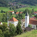
Osterzell from the west

Osterzell from the southwest
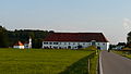
Salabeuren

lagging

Stocken, Oberzell and Salabeuren


Economy and Infrastructure
Economy including agriculture and forestry
In 1998 there were no employees in the field of agriculture and forestry, 320 in the manufacturing sector and no employees in the field of trade and transport at the place of work. In other areas of the economy, 228 people were employed at the place of work subject to social security contributions. There were three companies in the manufacturing sector and three in the construction sector. In addition, in 1999 there were 53 farms with an agriculturally used area of 2,673 ha. Of this, 2,115 ha were arable land and 558 ha were permanent green areas.
traffic

From 1923 there was a stop on the Kaufbeuren – Schongau railway in the Osterzell district of Stocken . In 1972 passenger traffic was stopped and the line closed. To the north of the stop, the route crossed a dirt road with the three-arched Osterzeller Viaduct that has been preserved to this day .
Today, the two themed cycle paths steam locomotive circuit and the Sachsenrieder train run on the former embankment of the Kaufbeuren-Schongau branch line . The latter was opened at the end of September 2013 and continues on or next to the railway line to Schongau station .
education
There is the following facility (as of 2014):
- Kindergarten: 39 kindergarten places with 38 children, including eleven children under three years of age.
Web links
- Entry on the coat of arms of Osterzell in the database of the House of Bavarian History
- Osterzell: Official statistics of the LfStat (PDF; 1.05 MB)
Individual evidence
- ↑ "Data 2" sheet, Statistical Report A1200C 202041 Population of the municipalities, districts and administrative districts 1st quarter 2020 (population based on the 2011 census) ( help ).
- ^ Osterzell community in the local database of the Bavarian State Library Online . Bayerische Staatsbibliothek, accessed on August 17, 2019.
- ^ Chronicle of the Osterzell community. In: osterzell.de. Osterzell community, accessed on June 22, 2020 .
- ↑ www.all-in.de , accessed on February 26, 2018.
- ^ Stephanie Heyl: Bavaria's communities - Osterzell community. In: hdbg.eu. House of Bavarian History, accessed on June 22, 2020 .

Aitrang | Baisweil | Bidingen | Biessenhofen | Buchloe | Eggenthal | Eisenberg | Friesenried | Feet | Germaringen | Görisried | Günzach | Halbch | Hopferau | Irsee | Jengen | Kaltental | Kraftisried | Lamerdingen | Lechbruck am See | Lengenwang | Marktoberdorf | Mauerstetten | Nesselwang | Obergünzburg | Oberostendorf | Osterzell | Pforzen | Pfronten | Rettenbach am Auerberg | Vineyards | Vineyards on the Forggensee | Ronsberg | Roßhaupten | Backwood | Ruderatshofen | Schwangau | Seeg | Stötten am Auerberg | Stöttwang | Unterthingau | Untrasried | Waal | Forest | Westendorf