
Gorisried
| coat of arms | Germany map | |
|---|---|---|

|
Coordinates: 47 ° 42 ' N , 10 ° 31' E |
|
| Basic data | ||
| State : | Bavaria | |
| Administrative region : | Swabia | |
| County : | Ostallgäu | |
| Management Community : | Unterthingau | |
| Height : | 803 m above sea level NHN | |
| Area : | 23.13 km 2 | |
| Residents: | 1316 (Dec. 31, 2019) | |
| Population density : | 57 inhabitants per km 2 | |
| Postal code : | 87657 | |
| Area code : | 08302 | |
| License plate : | OAL, FÜS, MOD | |
| Community key : | 09 7 77 131 | |
| Community structure: | 11 parts of the community | |
| Address of the municipal administration: |
Kirchplatz 8 87657 Görisried |
|
| Website : | ||
| Mayor : | Stephan Bea ( CSU ) | |
| Location of the municipality of Görisried in the Ostallgäu district | ||
  |
||

Görisried is a municipality in the Swabian district of Ostallgäu and a member of the Unterthingau administrative community .
geography
The community is located in the Allgäu planning region between the Kempter Forest in the west and the Wertach valley in the east. It is located at an altitude between 769 (Wertach) and 940 m above sea level (Klotzerbichl).
There is only the Görisried district .
The municipality has 11 officially named municipal parts (the type of settlement is given in brackets ):
|
|
In the municipality there was a pipe dump , which has meanwhile become deserted .


history
Until the church is planted
The history of Görisried probably begins with the early and high mediaeval planned clearing work in the Franconian Gau Keltenstein (800-1300). The prince monastery Kempten , the Hochstift Augsburg , the monastery St. Mang zu Füssen and the rule Kemnath were involved in it. In the documents, Görisried is mentioned for the first time in the 12th century in a legal dispute on Rothwasser near Wildberg. The first family names appear in documents from 1377.
Until 1803 the Görisried families were assigned to three different care offices: Oberdorf (Hochstift Augsburg), Nesselwang (St. Mang) and Unterthingau (Stift Kempten).
Since the Reichsdeputationshauptschluss of 1803 the place belongs to Bavaria . In the course of the administrative reforms in the Kingdom of Bavaria , today's municipality was created with the municipal edict of 1818 .
Population development
- 1970: 873 inhabitants
- 1987: 1011 inhabitants
- 1991: 1272 inhabitants
- 1995: 1409 inhabitants
- 2000: 1201 inhabitants
- 2005: 1266 inhabitants
- 2010: 1273 inhabitants
- 2015: 1340 inhabitants
Görisried grew by 230 inhabitants or approx. 22% from 1988 to 2008. Between 1988 and 2018 the municipality grew from 1,044 to 1,329 by 285 inhabitants or by 27.3%.
politics
The first mayor is Stephan Bea (CSU).
coat of arms
|
|
Blazon : “Split; in front a black ibex in gold, in the back split by red and silver with a clearing hoe placed at an angle to the left in mixed up colors. " |
Culture and sights
Country award of the village in gold
In 1998 Görisried received the silver medal in the national competition Our village has a future and gold in the state competition. A well-developed network of cycling and hiking trails makes Görisried a destination for nature lovers.
Go to GÖ
With go to GÖ there is a rock festival every year. Nationally known cover bands and live bands are on offer. These included Die Atzen , Mickie Krause , Sunrise Avenue , Doro Pesch , The Sweet , Revolverheld , Die Happy , Bananafishbones and JBO
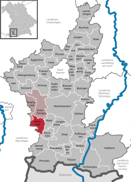
Catholic parish church St. Oswald
Görisried with the branches Wildberg and Stadels belonged to the parish of Oberthingau until the end of the Middle Ages, from which it was separated on November 5, 1497 as an independent parish. A new building from 1631 under master mason Matthäus Mayr and master carpenter Baltus Kienzle received a new tower in 1679 and was redesigned around 1720. The church, which was destroyed after the major fire of September 6, 1823, along with 36 houses in the village, was rebuilt in 1825/26, partially using the old walls, and consecrated in 1830, but after 20 years it was so dilapidated that in 1840/49 one that is still largely preserved today New building had to be built in neo-Gothic forms. Another restoration took place in 1947/49 with removal of the neo-Gothic elements and finally a complete modernization of the church and the surrounding cemetery at the end of the 1980s under Pastor Erwin Ruchte.
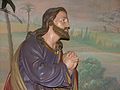
The stalls are from the time of the reconstruction in 1825/26. Also preserved is the former high altar painting from 1850, kneeling at the feet of Christ, the patron of the church of Görisried, St. Oswald, and the patron of the branch chapels, Saints Ursula, Petrus von Alcatara and Sebastian. Also preserved is the wooden figure of St. Oswald from 1730/40 in a more recent version and classicist frame, with the base inscription: ECCLESIAM / REX BAVARIAE RESTAURAVIT EX CINERE, BENEFICII ORNARUNT / A IGNATIUS / EPISCOPUS AUGUSTANUS / CONSECRAVIT. (Historical source: Michael Petzet: Landkreis Marktoberdorf, Bayerische Kunstdenkmale; 23, Munich: Deutscher Kunstverl., 1966).
Chapel of St. Ursula
The St. Ursula chapel is located about one kilometer south of the village of Görisried on the road to Wildberg. There the plague dead of the community were buried in 1634/35. In 1681 the choir and the eastern part of the nave were rebuilt. The ceiling painting with scenes from the legend of St. Ursula and the stalls.

Chapel of St. Peter of Alcantara in Stadels
The predecessor of this chapel was a field chapel built around 1675 in honor of St. Peter of Alcantara. In 1725, the Stadels branch community built the current large chapel in the village, which soon developed into a place of pilgrimage. The ceiling frescoes come from 1776 by the Kempten painter Linus Seif in stuccoed profile frames. The stigmatization of St. Francis can be seen in the nave in the main ceiling fields east of St. Peter of Alcantara and St. Teresia in clouds. The angel and the townscape of Stadels below have been completely repainted. In the six small round fields of the ceiling and the three gallery fields there are scenes from the life of the church patron. The coat of arms of Prince Abbot Rupert von Bodman (1678–1728) can be seen on the keystone of the choir arch .

Chapel of St Petrus Alcantara in Stadels
Interior of the church in Stadels


St. Sebastian Chapel in Wildberg
According to the building inscription on the gallery, a chapel that fell into disrepair in 1596 was rebuilt in 1652. Today's chapel, which is reminiscent of the surroundings of the Füssen master builder Johann Georg Fischer, dates back to a renovation in 1717 (the year above the choir arch).
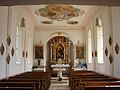
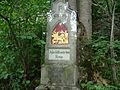
Calvary in Görisried
In 1867 the Görisrieder began building a calvary under pastor Wilhelm Eisele. The figures in the Ölberg Chapel are known to have been obtained by the architect Josef Müller in Munich.
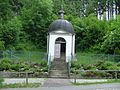
Mount of Olives Chapel built in 1881
The angel gives the cup to Jesus
Jesus on the Mount of Olives
One of the fourteen stations, built in 1868

Lourdes Chapel
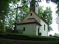
Upper chapel built in 1874, cross in 1888

Dungeon chapel

Source on the Way of the Cross


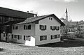
Architectural monuments
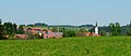
Görisried from the southwest
Historic Görisried

Hohenberg in the direction of the Ammer Mountains

Hohenberg towards the south

Stadels

Wildberg

.JPG)


Economy and Infrastructure
Economy including agriculture and forestry
In 2008, according to official statistics, there were no employees at the place of work in agriculture and forestry, 92 in manufacturing, 16 in trade, transport and hospitality and 42 in services. There were 432 employees at the place of residence subject to social security contributions. There were two companies in the manufacturing sector and four in the construction sector. In addition, in 2007 there were 51 farms with an agriculturally used area of 1375 ha. Of this, 1324 ha were permanent green space.
In 1997 Görisried was voted one of the most beautiful villages in Swabia.
education
In 2019 there were the following institutions:
- Day care center: 52 kindergarten places, 13 crèche places
- Primary school: 1st to 4th grade
Web links
- Official website of the municipality of Goerisried
- Görisried: Official statistics of the LfStat (PDF; 1.05 MB)
Individual evidence
- ↑ "Data 2" sheet, Statistical Report A1200C 202041 Population of the municipalities, districts and administrative districts 1st quarter 2020 (population based on the 2011 census) ( help ).
- ↑ Görisried community in the local database of the Bavarian State Library Online . Bayerische Staatsbibliothek, accessed on August 17, 2019 .. There, Röhrenhalde is still listed as a district, but it has meanwhile become deserted.
- ↑ Municipal Council (decision). Görisried municipality, accessed on August 2, 2020 .
- ↑ Entry on the coat of arms of Görisried in the database of the House of Bavarian History

Aitrang | Baisweil | Bidingen | Biessenhofen | Buchloe | Eggenthal | Eisenberg | Friesenried | Feet | Germaringen | Görisried | Günzach | Halbch | Hopferau | Irsee | Jengen | Kaltental | Kraftisried | Lamerdingen | Lechbruck am See | Lengenwang | Marktoberdorf | Mauerstetten | Nesselwang | Obergünzburg | Oberostendorf | Osterzell | Pforzen | Pfronten | Rettenbach am Auerberg | Vineyards | Vineyards on the Forggensee | Ronsberg | Roßhaupten | Backwood | Ruderatshofen | Schwangau | Seeg | Stötten am Auerberg | Stöttwang | Unterthingau | Untrasried | Waal | Forest | Westendorf