
Jengen
| coat of arms | Germany map | |
|---|---|---|

|
Coordinates: 48 ° 0 ' N , 10 ° 44' E |
|
| Basic data | ||
| State : | Bavaria | |
| Administrative region : | Swabia | |
| County : | Ostallgäu | |
| Management Community : | Buchloe | |
| Height : | 635 m above sea level NHN | |
| Area : | 33.75 km 2 | |
| Residents: | 2491 (Dec. 31, 2019) | |
| Population density : | 74 inhabitants per km 2 | |
| Postal code : | 86860 | |
| Area code : | 08241 | |
| License plate : | OAL, FÜS, MOD | |
| Community key : | 09 7 77 140 | |
| Community structure: | 8 parts of the community | |
| Address of the municipal administration: |
Kirchplatz 7 86860 Jengen |
|
| Website : | ||
| Mayor : | Ralf Neuner (Kom.Wver./ Überp.Wver. / Fr.Wver.) | |
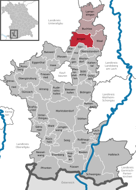
| Location of the community of Jengen in the Ostallgäu district | ||
  |
||


Jengen is a municipality in the Swabian district of Ostallgäu . The place of the same name is both the capital and the seat of the municipal administration.
geography
location
Jengen is located in the Ostallgäu district, as the gateway to the Allgäu, it does not belong to the Allgäu landscape. Jengen is located on the Lech-Wertach plain between 616 m above sea level (near the Wertach near Irsinger See) and 694 m above sea level (ridge west of Beckstetten). The main town Jengen is traversed by the river Gennach .
Parts of the community and districts
The municipality has eight officially named municipal parts (the type of settlement and the population as of December 31, 2018 are given in brackets ):
|
|
There are the districts of Jengen, Beckstetten, Eurishofen, Ummenhofen, Weicht and Weinhausen.
history
Until the church is planted
The establishment of the place goes back to 800 . Since some Celtic burial mounds were found near Weicht, there may have been Celtic settlements in the municipality before that. A mission station and a baptistery existed here already before 800 .
A lower nobility to Jengen was mentioned in the 12th century. Hiltprant and Konrad von Giengen appeared as witnesses in 1150. In the same period of time the place was mentioned as a painting (court) of the Margrave of Ronsberg .
In the Peasants' War from 1524 to 1526, the farmers in Jengen and Ummenhofen stuck to the Buchloe peasantry. Sebastian Bader was the leader of the group. During the Thirty Years War there was also an outbreak of the plague in Jengen with many deaths.
After the Thirty Years' War the Scapular Brotherhood was founded in 1665 , which in its prime had 2000 members.
Jengen belonged to the bishopric of Augsburg . Since the Reichsdeputationshauptschluss of 1803 the place belongs to Bavaria. In the course of the administrative reforms in the Kingdom of Bavaria , today's municipality was created with the municipal edict of 1818 .
Incorporations
On July 1, 1972, the previously independent community of Weinhausen was incorporated. On January 1, 1978 Beckstetten, Eurishofen, Ummenhofen and Weicht were added.
Population development
- 1961: 1623 inhabitants
- 1970: 1612 inhabitants
- 1987: 1709 inhabitants
- 1991: 1814 inhabitants
- 1995: 2095 inhabitants
- 2000: 2257 inhabitants
- 2005: 2375 inhabitants
- 2010: 2367 inhabitants
- 2015: 2405 inhabitants
- 2016: 2410 inhabitants
Jengen grew by 611 inhabitants or approx. 35% from 1988 to 2008. Jengen and the neighboring town of Buchloe had the highest percentage population growth in the Ostallgäu district during this period. Between 1988 and 2018, the community grew from 1,725 to 2,440 by 715 inhabitants or 41.5%.
politics
The community is a member of the Buchloe administrative association .
mayor
The first mayor is Ralf Neuner (municipal voter association / non-partisan WV / Free WV). In 2020, he became the successor of Franz Hauck (municipal electoral association / non-partisan WV / Free WV)
coat of arms
|
|
Blazon : “Split by silver and red; at the front of the gap a red armored half black eagle, at the back a left-facing golden griffin lion . "
The red-silver split comes from the old Augsburg bishopric coat of arms. The Kaufbeurer Spitalstiftung and the Steingaden Monastery can be proven to be historically significant landlords in the municipality . The half eagle at the gap comes from the coat of arms of the imperial city of Kaufbeuren, the griffin lion is taken from the coat of arms of the Steingaden monastery. |
Architectural monuments
- Catholic parish church of St. Martin

Beckstetten
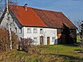
Swabian farmhouse in Jengen
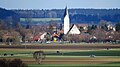
Jengen from the west

Gives way

Weinhausen


Economy and Infrastructure
Economy including agriculture and forestry
In 1998 there were no employees in the field of agriculture and forestry, 111 in the manufacturing sector and no employees in the field of trade and transport at the place of work. In other economic sectors 71 people were employed at the place of work subject to social security contributions. There were a total of 456 employees at the place of residence subject to social security contributions. In the manufacturing industry (as well as mining and quarrying of stones and earth) there was one company, in the main construction industry there was four companies. In addition, in 1999 there were 32 agricultural holdings with an agriculturally used area of 740 ha. 577 ha of this was arable land.
education
The following institutions exist (as of: 1999):
- Kindergartens: 100 kindergarten places with 94 children
- Elementary school: one with seven teachers and 160 students
Sports
- FC Jengen 1927 e. V.
Web links
- Local government
- Historical information on the Weinhausen district
- Jengen: Official statistics of the LfStat (PDF; 1.05 MB)
Individual evidence
- ↑ "Data 2" sheet, Statistical Report A1200C 202041 Population of the municipalities, districts and administrative districts 1st quarter 2020 (population based on the 2011 census) ( help ).
- ^ Community Jengen in the local database of the Bavarian State Library Online . Bayerische Staatsbibliothek, accessed on August 17, 2019.
- ↑ Numbers and Statistics. Retrieved October 21, 2018 .
- ^ Wilhelm Volkert (ed.): Handbook of Bavarian offices, communities and courts 1799–1980 . CH Beck, Munich 1983, ISBN 3-406-09669-7 , p. 492 .
- ↑ a b c Federal Statistical Office (ed.): Historical municipality directory for the Federal Republic of Germany. Name, border and key number changes in municipalities, counties and administrative districts from May 27, 1970 to December 31, 1982 . W. Kohlhammer, Stuttgart / Mainz 1983, ISBN 3-17-003263-1 , p. 779 .
- ↑ Numbers and Statistics. Retrieved October 21, 2018 .
- ↑ Mayor. Jengen municipality, accessed on August 26, 2020 .
- ^ Entry on Jengen's coat of arms in the database of the House of Bavarian History
Beckstetten | Eurishofen | Holy Cross Mill | Jengen | Koneberg | Ummenhofen | Gives way | Weinhausen

Aitrang | Baisweil | Bidingen | Biessenhofen | Buchloe | Eggenthal | Eisenberg | Friesenried | Feet | Germaringen | Görisried | Günzach | Halbch | Hopferau | Irsee | Jengen | Kaltental | Kraftisried | Lamerdingen | Lechbruck am See | Lengenwang | Marktoberdorf | Mauerstetten | Nesselwang | Obergünzburg | Oberostendorf | Osterzell | Pforzen | Pfronten | Rettenbach am Auerberg | Vineyards | Vineyards on the Forggensee | Ronsberg | Roßhaupten | Backwood | Ruderatshofen | Schwangau | Seeg | Stötten am Auerberg | Stöttwang | Unterthingau | Untrasried | Waal | Forest | Westendorf