
Untrasried
| coat of arms | Germany map | |
|---|---|---|

|
Coordinates: 47 ° 50 ' N , 10 ° 23' E |
|
| Basic data | ||
| State : | Bavaria | |
| Administrative region : | Swabia | |
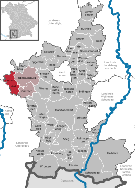
| County : | Ostallgäu | |
| Management Community : | Obergünzburg | |
| Height : | 819 m above sea level NHN | |
| Area : | 25.76 km 2 | |
| Residents: | 1584 (Dec. 31, 2019) | |
| Population density : | 62 inhabitants per km 2 | |
| Postal code : | 87496 | |
| Area code : | 08372 | |
| License plate : | OAL, FÜS, MOD | |
| Community key : | 09 7 77 176 | |
| Community structure: | 29 parts of the community | |
| Address of the municipal administration: |
Dorfstrasse 23 87496 Untrasried, Germany |
|
| Website : | ||
| Mayor : | Alfred Wölfle ( CSU ) | |
| Location of the municipality Untrasried in the Ostallgäu district | ||
  |
||


Untrasried is a municipality in the Swabian district of Ostallgäu and a member of the Obergünzburg administrative community .
geography
Untrasried is located in the Allgäu region in the Günztal and is the westernmost municipality in the Ostallgäu district. The western Günz rises on the southern outskirts . After about nineteen kilometers it joins the Lauben (Unterallgäu district) with the Eastern Günz to form the Günz, which flows into the Danube at Günzburg . The community lies between 725 m above sea level (western Günz) and 902 m above sea level (Eschers Höhe). The following districts exist : Hopferbach, Untrasried.
The municipality has 29 officially named parts of the municipality (the type of settlement is indicated in brackets ):
|
|
|
|
history
Until the church is planted
Untrasried belonged to the prince monastery of Kempten . Since the Reichsdeputationshauptschluss of 1803 the place belongs to Bavaria. In 1818, with the parish edict, today's parish was established.
Incorporations
On April 1, 1974, the previously independent community of Hopferbach volunteered to be incorporated into Untrasried.
Population development
- 1961: 1226 inhabitants
- 1970: 1131 inhabitants
- 1987: 1231 inhabitants
- 1991: 1313 inhabitants
- 1995: 1380 inhabitants
- 2000: 1443 inhabitants
- 2005: 1520 inhabitants
- 2010: 1528 inhabitants
- 2015: 1570 inhabitants
Between 1988 and 2008 Untrasried grew by 269 inhabitants or around 21%. Between 1988 and 2018, the community grew from 1257 to 1590 by 333 inhabitants or 26.5%.
politics
mayor
Mayor has been Alfred Wölfle since May 1996. He was nominated for a fifth term by the Eintracht Untrasried electoral group and elected for another six years on March 15, 2020 with 88.88% of the vote.
Municipal council
The election on March 15, 2020 had the following result:
- Eintracht Untrasried: 7 seats (60.60%)
- Hopferbach electoral bloc: 5 seats (39.40%).
The turnout was 69.94%.
coat of arms
The coat of arms shows a black horse jumping up in front, split by silver and blue, and a silver tower on a green three-mountain at the back.
Culture and sights
The height of Eschers (with 902 m above sea level the northernmost point over 900 m height south of the Danube in Bavaria) offers on a clear day an alpine panorama from the Karwendel to the Eastern Swiss Alps.

Architectural monuments
Regular events
Untrasried is known for the rock spring in the whole of the Allgäu and beyond. This festival takes place every spring and attracts almost 10,000 visitors to Untrasried on two evenings.
Economy and Infrastructure
Economy including agriculture and forestry
In 1998, according to official statistics, there were six in the field of agriculture and forestry, 71 in the manufacturing sector and five in the trade and transport sector at the place of work. In other economic areas, 24 people were employed at the place of work subject to social security contributions. There were a total of 466 employees at the place of residence subject to social security contributions. There were none in manufacturing and three in construction. In addition, in 1999 there were 80 farms with an agriculturally used area of 1883 hectares, of which 1867 hectares were permanent green space.
education
The following institutions exist (as of: 1999):
- Kindergarten: 50 kindergarten places
photos
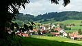
Hopferbach

Niederwang
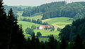
Siggenhorn

Simmerberg, the valley of the western Günz, Ottobeuren and Ulm on the horizon

Untrasried in winter

Untrasried from the southeast

Untrasried Dorfstrasse

Parish Church of Saint Sebastian


Web links
- Entry on the coat of arms of Untrasried in the database of the House of Bavarian History
- Untrasried: Official statistics of the LfStat (PDF; 1.05 MB)
Individual evidence
- ↑ "Data 2" sheet, Statistical Report A1200C 202041 Population of the municipalities, districts and administrative districts 1st quarter 2020 (population based on the 2011 census) ( help ).
- ^ Community Untrasried in the local database of the Bayerische Landesbibliothek Online . Bayerische Staatsbibliothek, accessed on August 17, 2019.
- ↑ a b c Federal Statistical Office (ed.): Historical municipality directory for the Federal Republic of Germany. Name, border and key number changes in municipalities, counties and administrative districts from May 27, 1970 to December 31, 1982 . W. Kohlhammer, Stuttgart / Mainz 1983, ISBN 3-17-003263-1 , p. 779 .

Aitrang | Baisweil | Bidingen | Biessenhofen | Buchloe | Eggenthal | Eisenberg | Friesenried | Feet | Germaringen | Görisried | Günzach | Halbch | Hopferau | Irsee | Jengen | Kaltental | Kraftisried | Lamerdingen | Lechbruck am See | Lengenwang | Marktoberdorf | Mauerstetten | Nesselwang | Obergünzburg | Oberostendorf | Osterzell | Pforzen | Pfronten | Rettenbach am Auerberg | Vineyards | Vineyards on the Forggensee | Ronsberg | Roßhaupten | Backwood | Ruderatshofen | Schwangau | Seeg | Stötten am Auerberg | Stöttwang | Unterthingau | Untrasried | Waal | Forest | Westendorf