Rettenbach am Auerberg
| coat of arms | Germany map | |
|---|---|---|

|
Coordinates: 47 ° 46 ' N , 10 ° 45' E |
|
| Basic data | ||
| State : | Bavaria | |
| Administrative region : | Swabia | |
| County : | Ostallgäu | |
| Management Community : | Stötten am Auerberg | |
| Height : | 832 m above sea level NHN | |
| Area : | 12.9 km 2 | |
| Residents: | 886 (Dec. 31, 2019) | |
| Population density : | 69 inhabitants per km 2 | |
| Postal code : | 87675 | |
| Area code : | 08860 | |
| License plate : | OAL, FÜS, MOD | |
| Community key : | 09 7 77 183 | |
| LOCODE : | DE RAA | |
| Community structure: | 6 parts of the community | |
| Address of the municipal administration: |
Dorfstrasse 1 87675 Rettenbach a.Auerberg |
|
| Website : | ||
| Mayor : | Reiner Friedl (village community) | |
| Location of the municipality of Rettenbach a.Auerberg in the Ostallgäu district | ||
Rettenbach am Auerberg (officially: Rettenbach a.Auerberg ) is a municipality in the Swabian district of Ostallgäu and a member of the administrative community of Stötten am Auerberg . Rettenbach is a state-approved resort .
geography
Only the district of Rettenbach a.Auerberg exists . The Auerberg itself does not belong to the municipality of Rettenbach, but to Bernbeuren and Stötten a.Auerberg . The highest point in Rettenbach is the Kappelhöhe (967 meters) near Weichberg. There is a telecommunications tower next to a chapel on the Kappelhöhe.
The municipality has six officially named municipality parts (the type of settlement is given in brackets ):
- Birkenberg ( wasteland )
- Frankau ( village )
- Oberlöchlers ( hamlet )
- Rettenbach am Auerberg ( Kirchdorf )
- Unterlöchlers (hamlet)
- Weichberg (wasteland)
There are also the Einödhöfe Höllbauer and Rupprechts, neither of which are officially designated parts of the community.
history
Incorporation and renewed independence
On May 1, 1978 Rettenbach was incorporated into Stötten am Auerberg . After tough arguments, Rettenbach has been self-employed again since October 6, 1993. Since then there has been an administrative partnership with Stötten. In 2007, the then second mayor Reiner Friedl commissioned the South Tyrolean composer Gottfried Veit to compose a song about this political situation. The various topics presented are: Motive of freedom - The untroubled everyday life - The forced integration to Stötten - Depression is spreading in the village - Memories of happy days - Thoughts of freedom - Russian immigration - The struggle for independence - Bells of joy (symbolize the Church bells that rang for hours in the village on the day of regained independence, October 6, 1993) - Hymn of Freedom (main theme). The freedom theme was also painted on the wall at the entrance to the Weichberghalle (above the Weichbergmarkt) as a symbol of the regained independence.
Population development
The community grew by 52 inhabitants or approx. 7% between 1995 and 2015.
| Population development | ||||||||||||||
|---|---|---|---|---|---|---|---|---|---|---|---|---|---|---|
| year | 1995 | 2000 | 2005 | 2008 | 2010 | 2012 | 2015 | 2016 | ||||||
| Residents | 775 | 732 | 766 | 792 | 810 | 805 | 827 | 845 | ||||||
politics
mayor
Mayor has been Reiner Friedl (village community) since May 1, 2014; he was confirmed in office on March 15, 2020 with 88.4% of the votes.
Municipal council
For the election on March 15, 2020 , only the nomination of the Rettenbach village community with 16 applicants was available. The 8 applicants from this group of voters with the highest number of votes form the local council for May 2020 to April 2026 together with the mayor. The turnout was 70.10%.
coat of arms
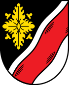
The description of the coat of arms reads: Divided diagonally by a wavy line; in front a gold rosette on black; behind a red wavy bar on silver.
Architectural monuments
economy
On the one hand, the economy of Rettenbach is characterized by agriculture; On the other hand, several medium-sized commercial enterprises (mechanical engineering) have their headquarters here, such as the forest machine manufacturer Pfanzelt Maschinenbau or the municipal machine manufacturer Kugelmann. Rettenbach owns Germany’s first self-service filling station for pure vegetable oil . To promote regional economic cycles, a new village shop, the "Weichbergmarkt", was built and opened on June 14, 2007. In the 2003/04, 2004/05, as well as 2006/07 and 2007/08 seasons, Rettenbach also took first place in the German Solar League , in which municipalities compete in terms of installed photovoltaic and solar thermal output.
Personalities
- Anton Geiß (1858–1944), politician (SPD), President of the Free State of Baden 1918–1920
Web links
- Entry on the coat of arms of Rettenbach am Auerberg in the database of the House of Bavarian History
- Rettenbach am Auerberg
- Pictures of the Weichberg and the Kappelhöhe
- Rettenbach am Auerberg: Official statistics of the LfStat (PDF; 1.05 MB)
Individual evidence
- ↑ "Data 2" sheet, Statistical Report A1200C 202041 Population of the municipalities, districts and administrative districts 1st quarter 2020 (population based on the 2011 census) ( help ).
- ^ Community Rettenbach am Auerberg in the local database of the Bavarian State Library Online . Bayerische Staatsbibliothek, accessed on August 17, 2019.
- ^ Federal Statistical Office (ed.): Historical municipality directory for the Federal Republic of Germany. Name, border and key number changes in municipalities, counties and administrative districts from May 27, 1970 to December 31, 1982 . W. Kohlhammer, Stuttgart / Mainz 1983, ISBN 3-17-003263-1 , p. 779 .
- ↑ StBA: Changes in the municipalities in Germany, see 1994


