
Backwood
| coat of arms | Germany map | |
|---|---|---|

|
Coordinates: 47 ° 39 ' N , 10 ° 32' E |
|
| Basic data | ||
| State : | Bavaria | |
| Administrative region : | Swabia | |
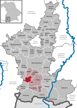
| County : | Ostallgäu | |
| Management Community : | Seeg | |
| Height : | 869 m above sea level NHN | |
| Area : | 17.23 km 2 | |
| Residents: | 878 (Dec. 31, 2019) | |
| Population density : | 51 inhabitants per km 2 | |
| Postal code : | 87494 | |
| Area code : | 08369 | |
| License plate : | OAL, FÜS, MOD | |
| Community key : | 09 7 77 168 | |
| LOCODE : | DE RKH | |
| Community structure: | 25 parts of the community | |
| Address of the municipal administration: |
Ortsstrasse 10 87494 Rückholz |
|
| Website : | ||
| Mayor : | Franz Erl (no party affiliation) | |
| Location of the municipality of Rückholz in the Ostallgäu district | ||
  |
||


Rückholz is a municipality in the Swabian district of Ostallgäu and a member of the Seeg administrative community .
geography
Rückholz is located in the Allgäu region in the lake district at the foot of the Allgäu Alps .
The municipal area is around 900 m above sea level. NHN high and has a number of idyllic ponds, including the Grundweiher, Luimooser Weiher, Neuweiher, Schönewalder Weiher, Schwaltenweiher and Trollweiher .
There is only the district Rückholz.
The municipality has 25 officially named municipal parts (the type of settlement is given in brackets ):
|
|
Around 450 people live in the main town, and another 400 people live in the 24 surrounding towns.
history
Until the church is planted
In the Middle Ages, Rückholz was the seat of a lordship that had belonged to the Sankt Mang monastery since 1474 . The seat of an upper and lower court fell to the princes Oettingen-Wallerstein in the Reichsdeputationshauptschluss 1803 . With the Rhine Confederation Act 1806, the place came to the Kingdom of Bavaria . In the course of the administrative reforms in Bavaria, the municipality of Rückholz came into being with the municipal edict of 1818 .
The rule of Falkensberg, owned by Emperor Maximilian around 1512 , also comprised part of what is now the municipality of Rückholz until its dissolution in 1610. The castle itself was demolished in 1593, a picture and a memorial stone at the castle builder court.
Population development
- 1961: 590 inhabitants
- 1970: 600 inhabitants
- 1987: 726 inhabitants
- 1991: 776 inhabitants
- 1995: 820 inhabitants
- 2000: 827 inhabitants
- 2005: 837 inhabitants
- 2010: 790 inhabitants
- 2015: 845 inhabitants
Backwood grew by 60 inhabitants or around eight percent from 1988 to 2008. Between 1988 and 2018, the municipality grew from 746 to 877 by 131 inhabitants or 17.6%.

Grundweiher

Wood people

Dandelion blossom at the Troll pond

Luimoos pond

Otten

Backwood

Castle courtyard

Schönewalder Weiher

Schwaltenweiher from the east
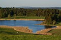
Troll pond


politics
mayor
Franz Erl has been the first mayor since 2014 (no party affiliation).
coat of arms
|
|
Blazon : "In red, agolden abbot's staff growingout of a silver three-mountain ." |
Attractions


- Catholic parish church of St. Georg (built before 1465, expanded in 1740) and rectory
- Mariengrotte (built in 1893)
Economy and Infrastructure
Economy including agriculture and forestry
In 1998, according to official statistics, there were 90 people in the manufacturing sector and no employees in the trade and transport sector at the place of work. There were a total of 259 employees at the place of residence subject to social security contributions. There were four in the manufacturing sector and no companies in the construction sector. In addition, in 1999 there were 68 farms with an agriculturally used area of 1447 ha, of which 1446 ha were permanent green space.
education
In 2009 the following institutions existed:
- Kindergartens: 27 kindergarten places with 24 children
Sons and daughters of the church
- Hans Angerer (* around 1620; † 1650 in Turin), lute maker
Web links
- Rückholz: Official statistics of the LfStat (PDF; 1.05 MB)
Individual evidence
- ↑ "Data 2" sheet, Statistical Report A1200C 202041 Population of the municipalities, districts and administrative districts 1st quarter 2020 (population based on the 2011 census) ( help ).
- ^ Community of Rückholz in the local database of the Bavarian State Library Online . Bayerische Staatsbibliothek, accessed on August 17, 2019 .. Incorrectly 26 districts there. A district of Brost does not exist.
- ^ Entry on the Rückholz coat of arms in the database of the House of Bavarian History

Aitrang | Baisweil | Bidingen | Biessenhofen | Buchloe | Eggenthal | Eisenberg | Friesenried | Feet | Germaringen | Görisried | Günzach | Halbch | Hopferau | Irsee | Jengen | Kaltental | Kraftisried | Lamerdingen | Lechbruck am See | Lengenwang | Marktoberdorf | Mauerstetten | Nesselwang | Obergünzburg | Oberostendorf | Osterzell | Pforzen | Pfronten | Rettenbach am Auerberg | Vineyards | Vineyards on the Forggensee | Ronsberg | Roßhaupten | Backwood | Ruderatshofen | Schwangau | Seeg | Stötten am Auerberg | Stöttwang | Unterthingau | Untrasried | Waal | Forest | Westendorf