Eiterberg
|
Eiterberg
Community Rückholz
Coordinates: 47 ° 40 ′ 38 ″ N , 10 ° 34 ′ 6 ″ E
|
|
|---|---|
| Postal code : | 87494 |
| Area code : | 08369 |
|
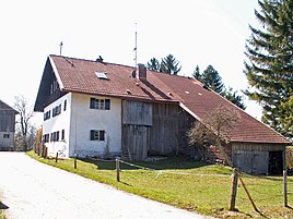
Old farmhouse in Eiterberg
|
|
Eiterberg is a part of the municipality of Rückholz in the Ostallgäu district . The village includes seventeen autonomous residential buildings that include housing and economic use.
Geographical location
The place is three kilometers northeast of the center of the municipality of Rückholz. It is at an altitude of about 850 m above sea level. NN.
Eiterberg can be reached by car via the Marktoberdorf-Nesselwang junction on federal motorway 7 .
Architectural monuments
See also: List of architectural monuments in Eiterberg
- chapel
economy
In Eiterberg, agriculture is mainly carried out in the form of traditional to modern dairy farms.
This, as well as the central location in the Allgäu foothills of the Alps, also makes tourism on the farms attractive and recorded as a supplementary source of income.
Web links
Commons : Eiterberg - collection of images, videos and audio files
- Eiterberg in the location database of the Bavarian State Library Online . Bavarian State Library
- Rückholz community
