
Waal (Swabia)
| coat of arms | Germany map | |
|---|---|---|

|
Coordinates: 48 ° 0 ' N , 10 ° 47' E |
|
| Basic data | ||
| State : | Bavaria | |
| Administrative region : | Swabia | |
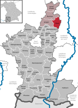
| County : | Ostallgäu | |
| Management Community : | Buchloe | |
| Height : | 635 m above sea level NHN | |
| Area : | 27.94 km 2 | |
| Residents: | 2342 (Dec. 31, 2019) | |
| Population density : | 84 inhabitants per km 2 | |
| Postal code : | 86875 | |
| Area code : | 08246 | |
| License plate : | OAL, FÜS, MOD | |
| Community key : | 09 7 77 177 | |
| Market structure: | 6 parts of the community | |
Market administration address : |
Marktplatz 1 86875 Waal |
|
| Website : | ||
| Mayor : | Robert Protschka ( Citizens' Block ) | |
| Location of the Waal market in the Ostallgäu district | ||
  |
||


Waal is a market in the Swabian district of Ostallgäu and a member of the Buchloe administration community .
geography
location
Waal lies on the edge of the Allgäu countryside. The Singold rises in the center and flows into the Wertach in Augsburg . After Buchloe is about eight kilometers away, Landsberg am Lech approximately twelve kilometers.
Expansion of the municipal area
The municipality consists of the districts Waal, Bronnen, Emmenhausen and Waalhaupten.
Parish parts
The municipality has six officially named municipality parts (the type of settlement is given in brackets ):
- Bronnen ( Kirchdorf )
- Buchhof ( wasteland )
- Emmenhausen ( parish village )
- Jägerhaus ( hamlet )
- Waal (main town)
- Waalhaupten (parish village)
In addition, there are the unofficial parts of the community Gut Haspelweiher and Ziegelstadel.
history
Until the church is planted
In the year 890 Waal was mentioned for the first time in an exchange document from the Ottobeuren monastery . The place receives 1444 from Emperor Friedrich III. the market law .
The Waal market was the seat of a lordship that belonged to Franz Ludwig Reichsgraf Schenk von Castell , the so-called Malefizschenk , around 1800 . With the Rheinbund act 1806 the place came to Bavaria . In the course of the administrative reforms in Bavaria, today's municipality was created with the municipal edict of 1818 .
Incorporations
On July 1, 1971, the previously independent community of Emmenhausen was incorporated. Bronnen followed on January 1, 1972. On May 1, 1978 Waalhaupten was added.
Population development
In the area of the market were counted:
| year | 1961 | 1970 | 1987 | 1995 | 2000 | 2005 | 2010 | 2015 |
| Residents | 1712 | 1737 | 1784 | 2004 | 2013 | 2189 | 2198 | 2250 |
Waal grew by 455 inhabitants between 1988 and 2008, i.e. around 26%. Between 1988 and 2018, the community grew from 1,763 to 2,341 by 578 inhabitants or 32.8%.
politics
City council and mayor
The municipal council has 14 members. In the municipal council election on March 16, 2014 , the result led to the following distribution of seats:
| Party / list | Share of votes | Seats |
| Civic bloc | 42.8% | 6th |
| Citizens' forum Emmenhausen-Bronnen | 25.2% | 4th |
| New list / GREEN | 16.7% | 2 |
| Free voters Waalhaupten | 15.3% | 2 |
Mayor has been Alois Porzelius (Waal citizens' block) since May 2008. In the 2014 local elections he was confirmed in office with 79.3% of the valid votes.
coat of arms
The coat of arms shows, in silver and growing out of silver clouds, Saint Nicholas in red robes, who is holding the crosier in his right hand and a missal with three golden balls in the left. It refers to the patron saint of the former parish church St. Nikolaus von Waal and has been run since the 18th century.
Culture and sights
- The parish village of Bronnen was awarded a gold medal in the national competition "Our village should be more beautiful" in 1989 and a silver medal in the national competition.
- The Waal Passion Play is performed irregularly and is one of the oldest Passion Play in Bavarian Swabia.
Attractions in the community are
- St. Nikolaus Church in Waal
- Catholic parish church St. Anna in Waal (with neo-Gothic interior)
- Waal Castle (residence of the Princely House of von der Leyen )
- Castle tavern
- Parish Church of St. Margareta in Bronnen
- Parish church of St. Ulrich in Emmenhausen
- Former parish church, today's cemetery church of St. Michael in Waalhaupten
- Catholic parish church of Our Lady of Sorrows in Waalhaupten

St. Anna
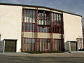
Passion play
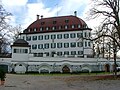
lock

Waal


Economy and Infrastructure
economy
In 2016, according to official statistics, there were twelve in the fields of agriculture, forestry and fishing, 156 in the manufacturing sector and no employees subject to social insurance contributions in the trade, transport and hospitality sector. In other economic sectors, eight people were employed at the place of work subject to social security contributions. There were a total of 922 employees at the place of residence subject to social security contributions. There were none in the manufacturing sector and five in the construction sector. In 2010 there were also 49 farms with a total of 1422 ha of agricultural land, of which 1095 ha were permanent green space.
education
The following institutions exist (as of 2017):
- a kindergarten with 80 kindergarten places attended by 77 children;
- a primary school with five teachers teaching 68 students;
- secondary schools (middle school, secondary school, high school) are located in Buchloe;
- a branch of the Buchloe Adult Education Center.
Local public transport
The place is connected to the local public transport with the bus line 17 of the transport company Kirchweihtal , which runs between the places Buchloe and Kaufbeuren. Regional trains on the Bavarian Allgäu Railway are reached at the two endpoints of the line .
Personalities
- Benedicta Riepp (1825–1862), religious, was born in Waal.
- Hubert von Herkomer (1849–1914), portrait painter and sculptor, pioneer of automobile racing in Germany, was born in Waal.
- Peter Dörfler (1878–1955), priest and writer, grew up in Waalhaupten.
- Otto Kobel (1919–2002) worked as a sculptor, church painter, actor and director in Waal.
Web links
- Entry on the coat of arms of Waal (Swabia) in the database of the House of Bavarian History
- Waal (Swabia): Official statistics of the LfStat (PDF; 1.05 MB)
Individual evidence
- ↑ "Data 2" sheet, Statistical Report A1200C 202041 Population of the municipalities, districts and administrative districts 1st quarter 2020 (population based on the 2011 census) ( help ).
- ^ Community Waal in the local database of the Bavarian State Library Online . Bayerische Staatsbibliothek, accessed on August 17, 2019.
- ^ Wilhelm Volkert (ed.): Handbook of Bavarian offices, communities and courts 1799–1980 . CH Beck, Munich 1983, ISBN 3-406-09669-7 , p. 492 .
- ↑ a b c Federal Statistical Office (ed.): Historical municipality directory for the Federal Republic of Germany. Name, border and key number changes in municipalities, counties and administrative districts from May 27, 1970 to December 31, 1982 . W. Kohlhammer, Stuttgart / Mainz 1983, ISBN 3-17-003263-1 , p. 779 .
- ^ Bavarian State Office for Statistics

Aitrang | Baisweil | Bidingen | Biessenhofen | Buchloe | Eggenthal | Eisenberg | Friesenried | Feet | Germaringen | Görisried | Günzach | Halbch | Hopferau | Irsee | Jengen | Kaltental | Kraftisried | Lamerdingen | Lechbruck am See | Lengenwang | Marktoberdorf | Mauerstetten | Nesselwang | Obergünzburg | Oberostendorf | Osterzell | Pforzen | Pfronten | Rettenbach am Auerberg | Vineyards | Vineyards on the Forggensee | Ronsberg | Roßhaupten | Backwood | Ruderatshofen | Schwangau | Seeg | Stötten am Auerberg | Stöttwang | Unterthingau | Untrasried | Waal | Forest | Westendorf