
Stötten am Auerberg
| coat of arms | Germany map | |
|---|---|---|

|
Coordinates: 47 ° 44 ' N , 10 ° 41' E |
|
| Basic data | ||
| State : | Bavaria | |
| Administrative region : | Swabia | |
| County : | Ostallgäu | |
| Management Community : | Stötten am Auerberg | |
| Height : | 733 m above sea level NHN | |
| Area : | 40.74 km 2 | |
| Residents: | 1890 (Dec. 31, 2019) | |
| Population density : | 46 inhabitants per km 2 | |
| Postal code : | 87675 | |
| Area code : | 08349 | |
| License plate : | OAL, FÜS, MOD | |
| Community key : | 09 7 77 171 | |
| Community structure: | 27 parts of the community | |
| Address of the municipal administration: |
Füssener Strasse 11 87675 Stötten |
|
| Website : | ||
| Mayor : | Ralf Grube ( general electorate ) | |
| Location of the municipality of Stötten a.Auerberg in the Ostallgäu district | ||
  |
||


Stötten am Auerberg (officially: Stötten a.Auerberg ; dialect : Schdeedda ) is a municipality in the Swabian district of Ostallgäu and the seat of the administrative community of Stötten am Auerberg .
geography
Stötten am Auerberg is located in the Allgäu region . The landscape around Stötten is characterized in particular by the 1055 m high Auerberg in the east and the Stötten high moors in the valley of the Geltnach to the west of the town. The Geltnach, a tributary of the Wertach , was regulated in 1912 due to frequent floods . To the west of the village there was a large lake that the Geltnach flowed through and which was drained from 1798. The community lies at an altitude between 722 and 1024 m above sea level .
The following districts exist : Remnatsried, Steinbach, Stötten am Auerberg.
The municipality has 27 officially named municipal parts (the type of settlement is given in brackets ):
|
|
|
history
Until the church is planted
In 1314 Stöttens was first mentioned as Steten auf dem Urberc . Stötten am Auerberg was part of the Augsburg monastery . Since the Reichsdeputationshauptschluss of 1803 the place belongs to Bavaria . In 1818 the community was founded.
Incorporations
On July 1, 1971, the previously independent municipality of Steinbach was incorporated. Remnatsried was added on July 1, 1976. Rettenbach am Auerberg followed on May 1, 1978. After tough disputes, Rettenbach has been independent again since January 1, 1994. Since then there has been an administrative partnership with the communities of Rettenbach am Auerberg and Stötten am Auerberg.
Population development
Between 1988 and 2008 Stötten a. A. 609 inhabitants or approx. 25%, in particular due to the departure of Rettenbach a. A. in 1994. Between 1995 and 2015 the community grew by 68 inhabitants or approx. 4%. All population figures refer to the area of today's municipality - except for the number for 1991, which Rettenbach a. A. includes.
|
|
|
* with Rettenbach a. A. / Source: BayLSt
politics
mayor
Mayor is Ralf Grube (general electorate). He was the successor to Joachim Ernst (general electorate) in 2014 and was re-elected on March 15, 2020 with 87.02%.
Municipal council
For the election on March 15, 2020 , only the nomination of the general electorate with 13 applicants was available. The 12 applicants from this group of voters with the highest number of votes form the municipal council together with the mayor from May 2020 to April 2026. The turnout was 65.37%.
Auerbergland
Stötten is a member municipality of the intermunicipal alliance " Auerbergland ", which crosses the borders of the administrative districts of Swabia and Upper Bavaria .
coat of arms
The description of the coat of arms reads: Under the red head of the shield, in it a silver wavy strip, in silver on a green trefoil a green trefoil cross, accompanied by two upright black ox horns.
Architectural monuments
Economy and Infrastructure
Economy including agriculture and forestry
In 1998, according to official statistics, there were seven in the field of agriculture and forestry, 71 in the manufacturing sector and 13 in the trade and transport sector at the place of work. In other economic sectors 40 people were employed at the place of work subject to social security contributions. There were a total of 586 employees at the place of residence subject to social security contributions. There was one company in the manufacturing sector and six companies in the main construction sector. In addition, there were 126 farms in 1999 with an agricultural area of 2,497 hectares, of which 21 hectares were arable land and 2,475 hectares were permanent green space.
traffic
Stötten is on federal highway 16 between Marktoberdorf and Füssen . From 1899 to 1973 there was a local railway line between Marktoberdorf and Lechbruck with stations also in Stötten and Steinbach, after which a regional cycle path was built on the route, which is now part of the so-called " steam locomotive circuit ".
education
The following institutions exist (as of: 1999):
- Kindergartens: 75 kindergarten places with 88 children
- Elementary schools: one with twelve teachers and 207 students
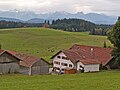
photos

Auerberg (1055 m above sea level) from the north

Hofstatt and Weidensee from Auerberg
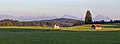
In the Stöttener Moos
Must

Remnatsried

Salchenried


Personalities
- Peter Alois Gratz (born August 17, 1769 in Mittelberg; † November 1, 1849 in Darmstadt), Catholic biblical scholar, grew up in Stötten am Auerberg
- Lorenz Clemens (von) Gratz (born January 26, 1806 in Stötten am Auerberg; † November 18, 1884 in Augsburg), nephew of Peter Alois Gratz , Catholic biblical scholar , Augsburg vicar general (1856–1882) and dean of the cathedral (1869–1884)
literature
- Franz Griesmann (author); Community of Stötten am Auerberg (Hrsg.): Home chronicle of the community of Stötten a. Auerberg. Stötten a. Auerberg 1990
- Hansjörg Küster ; Birgit Gehlen: On becoming a cultural landscape: vegetation-historical studies on the Auerberg, southern Bavaria. VCH, Acta Humaniora, Weinheim 1988, ISBN 3-527-17532-6
- Günter Ulbert , Werner Zanier , Christof Flügel : The Auerberg. (Munich contributions to prehistory and early history, 45), Beck'sche Verlagsbuchhandlung, Munich 1994
Web links
- Entry on the coat of arms of Stötten am Auerberg in the database of the House of Bavarian History
- Stötten am Auerberg: Official statistics of the LfStat (PDF; 1.05 MB)
Individual evidence
- ↑ "Data 2" sheet, Statistical Report A1200C 202041 Population of the municipalities, districts and administrative districts 1st quarter 2020 (population based on the 2011 census) ( help ).
- ^ Community of Stötten am Auerberg in the local database of the Bayerische Landesbibliothek Online . Bayerische Staatsbibliothek, accessed on August 17, 2019.
- ^ Wilhelm Volkert (ed.): Handbook of Bavarian offices, communities and courts 1799–1980 . CH Beck, Munich 1983, ISBN 3-406-09669-7 , p. 519 . }
- ^ Federal Statistical Office (ed.): Historical municipality directory for the Federal Republic of Germany. Name, border and key number changes in municipalities, counties and administrative districts from May 27, 1970 to December 31, 1982 . W. Kohlhammer, Stuttgart / Mainz 1983, ISBN 3-17-003263-1 , p. 779 .
- ↑ StBA: Changes in the municipalities in Germany, see 1994

Aitrang | Baisweil | Bidingen | Biessenhofen | Buchloe | Eggenthal | Eisenberg | Friesenried | Feet | Germaringen | Görisried | Günzach | Halbch | Hopferau | Irsee | Jengen | Kaltental | Kraftisried | Lamerdingen | Lechbruck am See | Lengenwang | Marktoberdorf | Mauerstetten | Nesselwang | Obergünzburg | Oberostendorf | Osterzell | Pforzen | Pfronten | Rettenbach am Auerberg | Vineyards | Vineyards on the Forggensee | Ronsberg | Roßhaupten | Backwood | Ruderatshofen | Schwangau | Seeg | Stötten am Auerberg | Stöttwang | Unterthingau | Untrasried | Waal | Forest | Westendorf