
Applicable
| Applicable | ||
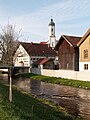
 Geltnach near Hörmanshofen |
||
| Data | ||
| Water code | DE : 12652 | |
| location |
Alpine foothills
|
|
| River system | Danube | |
| Drain over | Wertach → Lech → Danube → Black Sea | |
| source | west of Roßhaupten 47 ° 39 ′ 21 ″ N , 10 ° 41 ′ 52 ″ E |
|
| Source height | approx. 836 m above sea level NN | |
| muzzle | near Biessenhofen in the Wertach coordinates: 47 ° 49 '57 " N , 10 ° 38' 55" E 47 ° 49 '57 " N , 10 ° 38' 55" E |
|
| Mouth height | approx. 695 m above sea level NHN | |
| Height difference | approx. 141 m | |
| Bottom slope | approx. 5.4 ‰ | |
| length | 26.3 km | |
| Catchment area | 94.44 km² | |
| Discharge at the Hörmanshofen A Eo gauge : 95.3 km² Location: 1 km above the mouth |
NNQ (04.10.1961) MNQ 1941–2006 MQ 1941–2006 Mq 1941–2006 MHQ 1941–2006 HHQ (22.05.1999) |
80 l / s 363 l / s 1.9 m³ / s 19.9 l / (s km²) 30.9 m³ / s 64.4 m³ / s |
The Geltnach is a 26 km long, mainly northward running river in the Ostallgäu district , which flows into the Wertach from the right opposite Biessenhofen .
geography
course
The Geltnach rises west of Roßhaupten , turns early in the area of this community to the north run through a large forest area, where it briefly separates the area of the Seeg community , then longer that of the town of Marktoberdorf on the left from that of the community of Stötten am Auerberg on the right. She pulls a noose through the Stötten area and then changes to that of Marktoberdorf for a longer distance. After it has moved to the area of the municipality of Biessenhofen , it flows into the upper Wertach from the right opposite the village of the same name of the municipality .
In the charming Stöttener Moos, the Stöttener See was owned by the Augsburg bishops until around 1800, and was then drained. Part of the Geltnach, which was straightened over longer stretches at the beginning of the 20th century, is to be renatured from 2017.
Tributaries
From the source to the mouth. Selection of the larger ones.
- Schmutter , from the right and south to about 730 m above sea level. NHN west of Stötten am Auerberg - Heggen , 8.3 km and 8.8 km². Arises at about 850 m above sea level. NHN northwest of Roßhaupten - Hochegg .
- Kropersbach , from the right and to about 727 m above sea level. NHN north-west of Heggen, 7.7 km and 14.3 km². Arises at about 806 m above sea level. NHN northwest of Roßhaupten- Bischofswang .
- Röthenbach , from the left and west to about 726 m above sea level. NHN before Stötten, 2.4 km and 6.5 km². Longer with upper course Kesselbach . Arises at about 774 m above sea level. NHN north of Marktoberdorf - Sulzschneid .
- Mühlbach , from the right to about 725 m above sea level. NHN on the northern edge of Stötten, 6.4 km and 7.8 km². Arises at about 838 m above sea level. NHN southeast of Stötten am Auerberg- Salchenried .
Localities
Locations on the run with their affiliations. Only the names of the lowest nesting level denote neighboring settlements.
- municipality Roßhaupten
- Rieder (hamlet, left at a distance)
- Seeg municipality
- (without settlement, left)
- Municipality of Stötten am Auerberg
- (initially without settlement, right)
- City of Marktoberdorf
- (initially without settlement, left)
- Municipality of Stötten am Auerberg
- Stötten am Auerberg (parish village, mostly on the right)
- City of Marktoberdorf
- Bertoldshofen (parish village, more on the left)
- Hausen (village, right foot of the slope)
- community Biessenhofen
- Kreen (hamlet, left foot of the slope)
- Hörmanshofen (Kirchdorf, almost only on the left)
- Biessenhofen (parish village, opposite the estuary)
gallery

Geltnach spring area west of Roßhaupten

Geltnachtal near Stötten am Auerberg

Geltnach between Marktoberdorf and Stötten

Flood on the Geltnach in June 2013

Geltnachtal near Marktoberdorf
Geltnach in Bertoldshofen

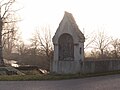
Former agricultural bridge over the Geltnach

Geltnachtal near Kreen
Geltnach near Biessenhofen


Individual evidence
- ^ Hansjörg Dongus : Geographical land survey: The natural space units on sheet 188/194 Kaufbeuren / Mittenwald. Federal Institute for Regional Studies, Bad Godesberg 1993. → Online map (PDF; 6.4 MB)
- ↑ a b List of brook and river areas in Bavaria - Lech river area, page 60 of the Bavarian State Office for the Environment, as of 2016 (PDF; 1.8 MB)
- ^ Deutsches Gewässerkundliches Jahrbuch Danube region 2006 Bavarian State Office for the Environment, p. 136, accessed on October 4, 2017, at: bestellen.bayern.de (PDF, German, 24.2 MB).
- ↑ Directory of creek and river areas in Bavaria - Lech river area, page 61 of the Bavarian State Office for the Environment, as of 2016 (PDF; 1.8 MB)