
Eggenthal
| coat of arms | Germany map | |
|---|---|---|

|
Coordinates: 47 ° 55 ' N , 10 ° 31' E |
|
| Basic data | ||
| State : | Bavaria | |
| Administrative region : | Swabia | |
| County : | Ostallgäu | |
| Management Community : | Eggenthal | |
| Height : | 713 m above sea level NHN | |
| Area : | 28.12 km 2 | |
| Residents: | 1357 (Dec. 31, 2019) | |
| Population density : | 48 inhabitants per km 2 | |
| Postcodes : | 87653, 87782 | |
| Area code : | 08347 | |
| License plate : | OAL, FÜS, MOD | |
| Community key : | 09 7 77 124 | |
| LOCODE : | DE EGH | |
| Community structure: | 20 parish parts | |
| Address of the municipal administration: |
Römerstrasse 12 87653 Eggenthal |
|
| Website : | ||
| First Mayor : | Karina Fischer ( CSU / Free Association of Voters) | |
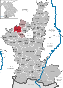
| Location of the municipality of Eggenthal in the Ostallgäu district | ||
  |
||


Eggenthal is a municipality in the Swabian district of Ostallgäu . The main town of the same name is the seat of the Eggenthal administrative community .
geography
The community lies on the edge of the Allgäu . The Romatsried castle stable is located in Romatsried , a place that may have been inhabited as early as the Bronze Age.
There are the districts of Bayersried and Eggenthal.
There are 20 officially named parts of the municipality (the type of settlement is given in brackets ):
|
|
|
history
Until the church is planted
Eggenthal is likely to be identical to the Roman station Navoa or Nawe. Both place names - Eggenthal and Nawe - appear next to each other in the Middle Ages. The place is on the Roman road Augsburg-Kempten. Presumably the Celts settled here before the Romans. The lords of Eggenthal are documented between 1130 and 1457. Around 1300 Bishop Wolfhart von Augsburg bought Eggenthal Castle for his church there. In 1316 it was owned by the Knights of Rohrbach as a Kemptic fiefdom, and in 1366 they sold it to the Lords of Schwarzenburg. Eggenthal later belonged to the imperial abbey of Irsee and came to Bavaria with the imperial deputation principal of 1803 . The Peasants 'War in 1525, the Thirty Years' War and the plague affected the place and its inhabitants considerably. In 1628 a plague cemetery was built on the Seelenberg and subsequently the Maria Seelenkapelle south of the village. In the course of the administrative reforms in the Kingdom of Bavaria , today's municipality was created with the municipal edict of 1818 .
Administrative affiliation
Until the territorial reform in 1972, the community belonged to the Kaufbeuren district , and since then to the Ostallgäu district. Eggenthal forms the administrative community of Eggenthal with the neighboring communities of Baisweil and Friesenried .
Incorporations
On January 1, 1978, the previously independent community of Bayersried was incorporated.
Population development
|
|
From 1988 to 2008 Eggenthal grew by 99 inhabitants or around eight percent. Between 1988 and 2018 the community grew from 1195 to 1368 by 173 inhabitants or 14.5%.
politics
Mayoress
Karina Fischer (CSU) has been mayor since May 2020. This was elected with 58.9% of the votes. Her predecessor was Harald Polzer (Free Voters' Association), in office from May 2008 to April 2020.
Municipal council
The election on March 15, 2020 had the following result:
- CSU: 5 seats (39.42%)
- Free voter association Eggenthal: 5 seats (42.20%)
- Free voter community Bayersried-Holzstetten: 2 seats (18.38%).
The turnout was 77.85%.
coat of arms
Description : In red on a green background, a silver milestone with the word NAWE on the base, accompanied by two maces with gold handles, divided five times by silver and black.
Architectural monuments
Soil monuments

Economy and Infrastructure
Economy including agriculture and forestry
In 1998 there were seven in the field of agriculture and forestry, 115 in the manufacturing sector and seven in the field of trade and transport at the place of work. In other economic sectors, 38 people were employed at the place of work subject to social security contributions. There were 364 employees at the place of residence subject to social security contributions. There was one in the manufacturing industry (as well as mining and quarrying of stones and earth) and five in the construction industry. In addition, in 1999 there were 76 farms with an agriculturally used area of 1628 ha. Of this, ha were arable land and 1592 ha were permanent green space.
education
In 1999 the following institutions existed:
- Kindergarten: 50 kindergarten places with 36 children
Sons and daughters of the church
- Johannes Hops (1681 - after 1730), sculptor
- Franz Xaver Bernhard (1726–1780), Baroque church painter
- Joseph Leitkrath (1736 or 1738–1811), painter and fresco artist of the Rococo
Web links
- Eggenthal community
- Eggenthal: Official statistics of the LfStat (PDF; 1.05 MB)
Individual evidence
- ↑ "Data 2" sheet, Statistical Report A1200C 202041 Population of the municipalities, districts and administrative districts 1st quarter 2020 (population based on the 2011 census) ( help ).
- ↑ Hello and welcome to the Eggenthal community website. Eggenthal community, accessed on June 11, 2020 .
- ^ Community Eggenthal in the local database of the Bavarian State Library Online . Bayerische Staatsbibliothek, accessed on August 17, 2019.
- ^ Verwaltungsgemeinschaft Eggenthal: Municipal council: Verwaltungsgemeinschaft Eggenthal. Retrieved May 14, 2020 .
- ↑ Entry on the Eggenthal coat of arms in the database of the House of Bavarian History
Bayersried | Binkenhofen | Look at | Blumenried | Eggenthal | Grub | Kreuzhof | Lausbihl | Mayers | Reichartsried | Röhrwang | Romatsried | Grinding mill | Handsome | Sonderhof | Stehlings | Sub-Webams | Völken | Webams | Wurmannswies

Aitrang | Baisweil | Bidingen | Biessenhofen | Buchloe | Eggenthal | Eisenberg | Friesenried | Feet | Germaringen | Görisried | Günzach | Halbch | Hopferau | Irsee | Jengen | Kaltental | Kraftisried | Lamerdingen | Lechbruck am See | Lengenwang | Marktoberdorf | Mauerstetten | Nesselwang | Obergünzburg | Oberostendorf | Osterzell | Pforzen | Pfronten | Rettenbach am Auerberg | Vineyards | Vineyards on the Forggensee | Ronsberg | Roßhaupten | Backwood | Ruderatshofen | Schwangau | Seeg | Stötten am Auerberg | Stöttwang | Unterthingau | Untrasried | Waal | Forest | Westendorf