
Kaufbeuren district
| coat of arms | Germany map | |
|---|---|---|

|
Coordinates: 47 ° 53 ' N , 10 ° 37' E |
|
| Basic data (as of 1972) | ||
| Existing period: | 1862-1972 | |
| State : | Bavaria | |
| Administrative region : | Swabia | |
| Administrative headquarters : | Kaufbeuren | |
| Area : | 503.77 km 2 | |
| Residents: | 38,400 (Dec. 31, 1971) | |
| Population density : | 76 inhabitants per km 2 | |
| License plate : | Theatrical Version | |
| Circle key : | 09 7 38 | |
| Circle structure: | 56 municipalities | |
| Address of the district administration: |
8950 Kaufbeuren | |
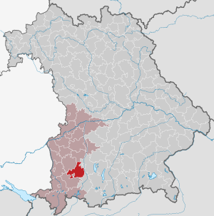
| Location of the district of Kaufbeuren in Bavaria | ||
  |
||

The district of Kaufbeuren belonged to the Bavarian administrative district of Swabia . At the beginning of the regional reform in Bavaria in the early 1970s, it had 56 communities.
geography
Important places
The largest places were Buchloe , Mauerstetten and Waal .
Neighboring areas
In 1972 the district bordered clockwise to the north, starting with the districts of Schwabmünchen , Landsberg am Lech , Schongau and Marktoberdorf , the independent city of Kaufbeuren and the district of Mindelheim .
history
District Office
The district office Kaufbeuren was formed in 1862 through the merger of the regional courts of the older order Buchloe and Kaufbeuren . The city of Kaufbeuren remained a direct city and did not belong to the district office.
On the occasion of the reform of the layout of the Bavarian district offices, the Kaufbeuren district office received municipalities from the Mindelheim district office on January 1, 1880 .
district
On January 1, 1939, the designation district was introduced as everywhere else in the German Reich . So the district office became the district of Kaufbeuren.
On April 1, 1940, the independent city of Kaufbeuren was incorporated into the district. This was reversed on April 1, 1948.
On July 1, 1972, the district of Kaufbeuren was dissolved as part of the regional reform in Bavaria :
- The communities of Hirschzell and Oberbeuren were incorporated into the independent city of Kaufbeuren.
- The municipalities Asch , Denklingen , Dien Hausen , Ellighofen , Leeder , Upper Dießen , Seestall and Unterdießen came to the district of Landsberg am Lech in the district of Upper Bavaria .
- The community Schlingen came to the new district of Mindelheim, whose name was changed on May 1, 1973 to the district of Unterallgäu .
- All other municipalities were combined with the district of Füssen and most of the district of Marktoberdorf to form a new district of Marktoberdorf, whose name was changed to Ostallgäu on May 1, 1973 .
Population development
| year | Residents | source |
|---|---|---|
| 1864 | 19,131 | |
| 1885 | 21,968 | |
| 1900 | 23,282 | |
| 1910 | 25,071 | |
| 1925 | 25,581 | |
| 1939 | 37,434 | |
| 1950 | 39,216 | |
| 1960 | 35,600 | |
| 1971 | 38,400 |
Communities
The municipalities of the Kaufbeuren district before the municipal reform. Churches that still exist today are written in bold .
| former parish | today's parish | today's district | |
|---|---|---|---|
| 1 | Apple strand | Ruderatshofen | District of Ostallgäu |
| 2 | Ash | Fuchstal | Landsberg am Lech district |
| 3 | Aufkirch | Kaltental | District of Ostallgäu |
| 4th | Baisweil | Baisweil | District of Ostallgäu |
| 5 | Beckstetten | Jengen | District of Ostallgäu |
| 6th | Blonhofen , market | Kaltental | District of Ostallgäu |
| 7th | Well | Waal | District of Ostallgäu |
| 8th | Buchloe , city | Buchloe | District of Ostallgäu |
| 9 | Thinkers | Thinkers | Landsberg am Lech district |
| 10 | Dienhausen | Thinkers | Landsberg am Lech district |
| 11 | Dillishausen | Lamerdingen | District of Ostallgäu |
| 12 | Dösingen | Westendorf | District of Ostallgäu |
| 13 | Eggenthal | Eggenthal | District of Ostallgäu |
| 14th | Ellighofen | Landsberg am Lech | Landsberg am Lech district |
| 15th | Emmenhausen | Waal | District of Ostallgäu |
| 16 | Eurishofen | Jengen | District of Ostallgäu |
| 17th | Frankenhofen | Kaltental | District of Ostallgäu |
| 18th | Frankenried | Mauerstetten | District of Ostallgäu |
| 19th | Großkitzighofen | Lamerdingen | District of Ostallgäu |
| 20th | Gutenberg | Oberostendorf | District of Ostallgäu |
| 21st | Hirschzell | Kaufbeuren | Independent city of Kaufbeuren |
| 22nd | Honsolgen | Buchloe | District of Ostallgäu |
| 23 | Ingenried | Pforzen | District of Ostallgäu |
| 24 | Irsee , market | Irsee | District of Ostallgäu |
| 25th | Jengen | Jengen | District of Ostallgäu |
| 26th | Ketterschwang | Germaringen | District of Ostallgäu |
| 27 | Small emnat | Kaufbeuren | Independent city of Kaufbeuren |
| 28 | Kleinkitzighofen | Lamerdingen | District of Ostallgäu |
| 29 | Lamerdingen | Lamerdingen | District of Ostallgäu |
| 30th | Lauchdorf | Baisweil | District of Ostallgäu |
| 31 | Leeder , market | Fuchstal | Landsberg am Lech district |
| 32 | Lengenfeld | Oberostendorf | District of Ostallgäu |
| 33 | Linden trees | Stöttwang | District of Ostallgäu |
| 34 | Lindenberg | Buchloe | District of Ostallgäu |
| 35 | Mauerstetten | Mauerstetten | District of Ostallgäu |
| 36 | Oberbeuren | Kaufbeuren | Independent city of Kaufbeuren |
| 37 | Oberdießen | Unterdießen | Landsberg am Lech district |
| 38 | Obergermaringen | Germaringen | District of Ostallgäu |
| 39 | Oberostendorf | Oberostendorf | District of Ostallgäu |
| 40 | Osterzell | Osterzell | District of Ostallgäu |
| 41 | Pforzen | Pforzen | District of Ostallgäu |
| 42 | Reichenbach | Stöttwang | District of Ostallgäu |
| 43 | Vineyards | Vineyards | District of Ostallgäu |
| 44 | Loops | Bad Woerishofen | District of Unterallgäu |
| 45 | Sea stable | Fuchstal | Landsberg am Lech district |
| 46 | Stöttwang | Stöttwang | District of Ostallgäu |
| 47 | Thalhofen an der Gennach | Stöttwang | District of Ostallgäu |
| 48 | Ummenhofen | Jengen | District of Ostallgäu |
| 49 | Unterdießen | Unterdießen | Landsberg am Lech district |
| 50 | Untergermaringen | Germaringen | District of Ostallgäu |
| 51 | Unterostendorf | Oberostendorf | District of Ostallgäu |
| 52 | Waal , market | Waal | District of Ostallgäu |
| 53 | Waalhaupten | Waal | District of Ostallgäu |
| 54 | Gives way | Jengen | District of Ostallgäu |
| 55 | Weinhausen | Jengen | District of Ostallgäu |
| 56 | Westendorf | Westendorf | District of Ostallgäu |
The municipality of Dornstetten was incorporated into Unterdießen on March 1, 1925.
License Plate
On July 1, 1956, the district was assigned the KF distinguishing mark when the license plates that are still valid today were introduced . It is only issued in the city of Kaufbeuren until today. In the Ostallgäu district it was issued until August 3, 1974.
Individual evidence
- ^ Wilhelm Volkert (ed.): Handbook of Bavarian offices, communities and courts 1799–1980 . CH Beck, Munich 1983, ISBN 3-406-09669-7 , p. 492 .
- ^ Wilhelm Volkert (ed.): Handbook of Bavarian offices, communities and courts 1799–1980 . CH Beck, Munich 1983, ISBN 3-406-09669-7 , p. 97 .
- ^ Federal Statistical Office (ed.): Historical municipality directory for the Federal Republic of Germany. Name, border and key number changes in municipalities, counties and administrative districts from May 27, 1970 to December 31, 1982 . W. Kohlhammer, Stuttgart / Mainz 1983, ISBN 3-17-003263-1 , p. 777 and 779 .
- ^ Ordinance on the reorganization of Bavaria into rural districts and independent cities of December 27, 1971
- ^ Eugen Hartmann: Statistics of the Kingdom of Bavaria . Ed .: Royal Bavarian Statistical Bureau. Munich 1866, population figures of the district offices 1864 ( digitized version ).
- ↑ Royal Bavarian Statistical Bureau (ed.): Localities directory of the Kingdom of Bavaria . Munich 1888, population figures of the district offices 1885 ( digitized ).
- ↑ a b www.gemeindeververzeichnis.de
- ^ Localities directory for the Free State of Bavaria, based on the census of June 16, 1925
- ↑ Statistical Yearbook for the German Reich 1940
- ↑ Statistical Yearbook for the Federal Republic of Germany 1952
- ↑ Statistical Yearbook for the Federal Republic of Germany 1961
- ↑ Statistical Yearbook for the Federal Republic of Germany 1973
- ^ Michael Rademacher: German administrative history from the unification of the empire in 1871 to the reunification in 1990. Kaufbeuren district. (Online material for the dissertation, Osnabrück 2006). }
- ↑ BayernViewer of the Bavarian Surveying Administration (accessed on July 14, 2010)
literature
- Richard Dertsch : Stadt- und Landkreis Kaufbeuren (= historical place name book of Bavaria. Swabia . Vol. 3). Commission for Bavarian State History, Munich 1960
- Tilmann Breuer : City and district of Kaufbeuren. (Brief inventory) (= Bavarian art monuments . Vol. 9, ISSN 0522-5264 ). German art publisher, Munich 1960
Aichach | Alzenau i.UFr. | Amberg | Bad Aibling | Bad Neustadt adSaale | Bad Toelz | Beilngries | Berchtesgaden | Bow | Brückenau | Burglengenfeld | Dingolfing | Dinkelsbühl | Donauwörth | Ebermannstadt | Boars | Eggenfelden | Erlangen | Eschenbach idOPf. | Feuchtwangen | Friedberg | Feet | Gemünden a.Main | Gerolzhofen | Grafenau | Griesbach i.Rottal | Gunzenhausen | Hammelburg | Hassfurt | Hersbruck | Hilpoltstein | Höchstadt adAisch | Hofheim i.UFr. | Illertissen | Ingolstadt | Karlstadt | Kaufbeuren | Kemnath | Kempten (Allgäu) | Königshofen i.Grabfeld | Kötzting | Krumbach (Swabia) | Landau adIsar | Lauf adPegnitz | Running | Lohr a.Main | Mainburg | Mallersdorf | Marktheidenfeld | Marktoberdorf | Mellrichstadt | Memmingen | Mindelheim | Münchberg | Nabburg | Naila | Neuburg adDonau | Neunburg vorm Wald | Neustadt adAisch | Nordlingen | Nuremberg | Obernburg am Main | Oberviechtach | Ochsenfurt | Parsberg | Pegnitz | Parish churches | Rehau | Riedenburg | Roding | Rothenburg ob der Tauber | Rottenburg adLaaber | Scheinfeld | Schongau | Schrobenhausen | Schwabach | Schwabmünchen | Sonthofen | Stadtsteinach | Staffelstein | Straubing | Sulzbach-Rosenberg | Uffenheim | Viechtach | Vilsbiburg | Vilshofen | Vohenstrauss | Waldmünchen | Wasserburg a.Inn | Wegscheid | Weilheim i.OB | Weißenburg i.Bay. | Wertingen | Wolfratshausen | Wolfstein
1939–1945 affiliated districts: Bergreichenstein | Eisenstein market | Prachatitz