
District of Pegnitz
| coat of arms | Germany map | |
|---|---|---|

|
Coordinates: 49 ° 45 ' N , 11 ° 32' E |
|
| Basic data (as of 1972) | ||
| State : | Bavaria | |
| Administrative region : | Upper Franconia | |
| Administrative headquarters : | Pegnitz | |
| Area : | 557.69 km 2 | |
| Residents: | 38,878 (May 27, 1970) | |
| Population density : | 70 inhabitants per km 2 | |
| License plate : | PEG | |
| Circle key : | 09 4 43 | |
| Circle structure: | 64 municipalities | |
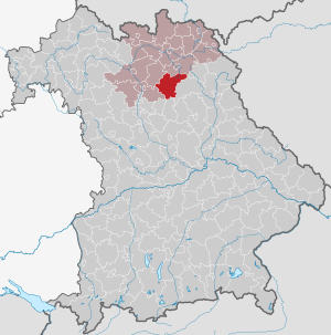
| Location of the Pegnitz district in Bavaria | ||
  |
||

The district of Pegnitz belonged to the Bavarian administrative district of Upper Franconia . Before the Bavarian regional reform began in the early 1970s, the district comprised 64 communities. Most of them came to the districts of Bayreuth and Forchheim .
geography
Important places
The most populous communities were Pegnitz , Pottenstein , Creußen and Gößweinstein .
Neighboring areas
In 1972 the district bordered clockwise, starting in the north, with the districts of Bayreuth , Eschenbach in the Upper Palatinate , Hersbruck , Forchheim and Ebermannstadt .
history
District Office
The Pegnitz District Office was formed in 1862 through the merger of the Pegnitz and Pottenstein regional courts .
The district office of Lauf an der Pegnitz was formed in 1908 by spinning off the district offices of Hersbruck and Pegnitz.
district
On January 1, 1939, the uniform imperial designation Landkreis was introduced. So the district office of Pegnitz became the district office.
On July 1, 1972, the district of Pegnitz was dissolved as part of the regional reform in Bavaria :
- The communities Bärnfels, Behringersmühle , Bieberbach , Geschwand, Gößweinstein , Kleingesee , Leutzdorf , Moggast, Morschreuth , Obertrubach , Stadelhofen, Unterailsfeld, Wichsenstein and Wolfsberg came to the Forchheim district.
- The municipality of Höfen came to the district of Lauf an der Pegnitz , which was given its current name of the district of Nürnberger Land on May 1, 1973 .
- All other communities came to the district of Bayreuth.
Population development
| year | Residents | source |
|---|---|---|
| 1864 | 27,449 | |
| 1885 | 28,178 | |
| 1900 | 26,157 | |
| 1910 | 26,578 | |
| 1925 | 26,561 | |
| 1939 | 27,490 | |
| 1950 | 38,675 | |
| 1960 | 36,000 | |
| 1971 | 39,100 |
Communities
Places in italics are still independent communities today. In the places that are no longer independent today, it is noted which municipality the place belongs to today.
|
Other communities
|
License Plate
On July 1, 1956, the district was assigned the distinctive sign PEG when the vehicle registration number that is still valid today was introduced . It was issued until August 3, 1974. Since July 10, 2013 it has been available again in the districts of Bayreuth and Forchheim due to the license plate liberalization, and since July 15, 2013 also in the district of Nürnberger Land.
literature
- Hedwig Ort: Economic development and rural exodus in the Pegnitz district. sn, sl 1948 (typewritten).
- Michael Petzet (ed.): The art monuments of Upper Franconia. Volume 2, 8: Heinrich Kreisel (Ed.): Administrative region of Upper Franconia. District of Pegnitz. Bayerische Verlags-Anstalt ao, Bamberg ao 1961.
- Josef Pfanner: District of Pegnitz (= historical book of place names of Bavaria, Upper Franconia . Volume 2 ). Commission for Bavarian State History, Munich 1965, DNB 457000961 .
- Alfred Schädler: District of Pegnitz (= The art monuments of Bavaria . Upper Franconia 2). R. Oldenburg, Munich 1961, DNB 457322586 .
Individual evidence
- ^ Official register of places for Bavaria 1964
- ^ Wilhelm Volkert (ed.): Handbook of Bavarian offices, communities and courts 1799–1980 . CH Beck, Munich 1983, ISBN 3-406-09669-7 , p. 549 .
- ^ Wilhelm Volkert (ed.): Handbook of Bavarian offices, communities and courts 1799–1980 . CH Beck, Munich 1983, ISBN 3-406-09669-7 , p. 97 .
- ^ Federal Statistical Office (ed.): Historical municipality directory for the Federal Republic of Germany. Name, border and key number changes in municipalities, counties and administrative districts from May 27, 1970 to December 31, 1982 . W. Kohlhammer, Stuttgart / Mainz 1983, ISBN 3-17-003263-1 , p. 697 and 719 .
- ^ Ordinance on the reorganization of Bavaria into rural districts and independent cities of December 27, 1971
- ^ Eugen Hartmann: Statistics of the Kingdom of Bavaria . Ed .: Royal Bavarian Statistical Bureau. Munich 1866, population figures of the district offices 1864 ( digitized version ).
- ↑ Royal Bavarian Statistical Bureau (ed.): Localities directory of the Kingdom of Bavaria . Munich 1888, population figures of the district offices 1885 ( digitized ).
- ↑ a b www.gemeindeververzeichnis.de: Upper Franconia
- ^ Localities directory for the Free State of Bavaria, based on the census of June 16, 1925
- ↑ Statistical Yearbook for the German Reich 1940
- ↑ Statistical Yearbook for the Federal Republic of Germany 1952
- ↑ Statistical Yearbook for the Federal Republic of Germany 1961
- ↑ Statistical Yearbook for the Federal Republic of Germany 1973
Aichach | Alzenau i.UFr. | Amberg | Bad Aibling | Bad Neustadt adSaale | Bad Toelz | Beilngries | Berchtesgaden | Bow | Brückenau | Burglengenfeld | Dingolfing | Dinkelsbühl | Donauwörth | Ebermannstadt | Boars | Eggenfelden | Erlangen | Eschenbach idOPf. | Feuchtwangen | Friedberg | Feet | Gemünden a.Main | Gerolzhofen | Grafenau | Griesbach i.Rottal | Gunzenhausen | Hammelburg | Hassfurt | Hersbruck | Hilpoltstein | Höchstadt adAisch | Hofheim i.UFr. | Illertissen | Ingolstadt | Karlstadt | Kaufbeuren | Kemnath | Kempten (Allgäu) | Königshofen i.Grabfeld | Kötzting | Krumbach (Swabia) | Landau adIsar | Lauf adPegnitz | Running | Lohr a.Main | Mainburg | Mallersdorf | Marktheidenfeld | Marktoberdorf | Mellrichstadt | Memmingen | Mindelheim | Münchberg | Nabburg | Naila | Neuburg adDonau | Neunburg vorm Wald | Neustadt adAisch | Nordlingen | Nuremberg | Obernburg am Main | Oberviechtach | Ochsenfurt | Parsberg | Pegnitz | Parish churches | Rehau | Riedenburg | Roding | Rothenburg ob der Tauber | Rottenburg adLaaber | Scheinfeld | Schongau | Schrobenhausen | Schwabach | Schwabmünchen | Sonthofen | Stadtsteinach | Staffelstein | Straubing | Sulzbach-Rosenberg | Uffenheim | Viechtach | Vilsbiburg | Vilshofen | Vohenstrauss | Waldmünchen | Wasserburg a.Inn | Wegscheid | Weilheim i.OB | Weißenburg i.Bay. | Wertingen | Wolfratshausen | Wolfstein
1939–1945 affiliated districts: Bergreichenstein | Eisenstein market | Prachatitz