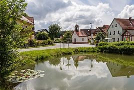
Leutzdorf
|
Leutzdorf
Gößweinstein market
Coordinates: 49 ° 45 ′ 52 ″ N , 11 ° 18 ′ 15 ″ E
|
|
|---|---|
| Height : | 434 m |
| Residents : | 134 |
| Incorporation : | 1st January 1974 |
| Postal code : | 91327 |
| Area code : | 09242 |
|
Town center
|
|
Leutzdorf is a district of Gößweinstein in the Upper Franconian district of Forchheim and has about 130 inhabitants.
The village is three kilometers west of the center of Gößweinstein. The highest point is the Kulm at 516 m above sea level. The lowest point is in the center of the village at 437 m above sea level.
Geographical location
Leutzdorf is located in the heart of Franconian Switzerland , in the middle of the city triangle Bamberg , Bayreuth and the metropolitan region of Nuremberg .
history
In the course of the regional reform, the municipality of Leutzdorf (consisting of the districts Etzdorf, Hartenreuth, Türkelstein and Sachsenmühle) was dissolved on January 1, 1974 and incorporated into the Gößweinstein market.
Tourism and tourism
In addition to a home-style eatery, Leutzdorf offers private pensions and holiday apartments with around 50 beds. Leutzdorf is integrated into a network of hiking trails and also offers a domicile for mountain bikers and climbing freaks. The Kanndorf and Pottenstein golf courses can be reached in five to ten minutes by car.
Culture and sights
- Esper cave
- Leutzdorfer Wall
societies
- Volunteer fire brigade Leutzdorf 1899
Individual evidence
- ^ Federal Statistical Office (ed.): Historical municipality directory for the Federal Republic of Germany. Name, border and key number changes in municipalities, counties and administrative districts from May 27, 1970 to December 31, 1982 . W. Kohlhammer GmbH, Stuttgart / Mainz 1983, ISBN 3-17-003263-1 , p. 683 .
