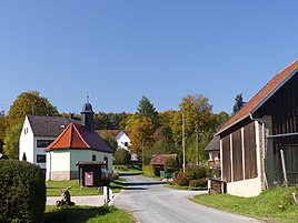
Sachsendorf (Gößweinstein)
|
Saxon village
Gößweinstein market
Coordinates: 49 ° 45 ′ 35 ″ N , 11 ° 22 ′ 28 ″ E
|
|
|---|---|
| Height : | 436 (433-463) m above sea level NHN |
| Residents : | 61 (Jul 1, 2019) |
| Postal code : | 91327 |
| Area code : | 09242 |
|
The Gößweinsteiner district of Sachsendorf
|
|
Sachsendorf is a Franconian village that belongs to Gößweinstein .
geography
The in Wiesentalb located village is one of 31 officially designated community parts of the Upper Franconian market Gößweinstein. Sachsendorf is located about three kilometers east-southeast of the center of Gößweinstein at an altitude of 436 m above sea level. NHN .
history
Until the beginning of the 19th century, Sachsendorf was under the sovereignty of the Bamberg Monastery. When the Bamberg Monastery was secularized as a result of the Reichsdeputationshauptschluss 1802/03 and annexed by the Electorate Palatinate-Baiern in breach of the Imperial Constitution , Sachsendorf became part of the New Bavarian territories that were forcibly taken over during the Napoleonic land consolidation .
As a result of the administrative reforms carried out in the Kingdom of Bavaria at the beginning of the 19th century , with the second municipal edict in 1818 , Sachsendorf became part of the independent rural municipality of Stadelhofen , to which the towns of Allersdorf , Bösenbirkig , Geiselhöhe , Prügeldorf and Siegmannsbrunn also belonged. In the course of the communal territorial reform carried out in Bavaria in the 1970s , Sachsendorf was incorporated into the Gößweinstein market together with the Stadelhofen community at the beginning of 1972. In 2019 Sachsendorf had 61 inhabitants.
traffic
A community road coming from Stadelhofen crosses the village and continues to Siegmannsbrunn. In the center of the village, another road branches off and leads northwest to the state road St 2685 . The place is served by public transport at a bus stop on bus line 232 of the VGN . The closest train station is in Ebermannstadt , it is the commercial terminus of the Wiesenttalbahn .
literature
- Gertrud Diepolder : Bavarian History Atlas . Ed .: Max Spindler . Bayerischer Schulbuch Verlag, Munich 1969, ISBN 3-7627-0723-5 .
- Federal Statistical Office (Hrsg.): Historical municipality register for the Federal Republic of Germany. Name, border and key number changes in municipalities, counties and administrative districts from May 27, 1970 to December 31, 1982 . W. Kohlhammer, Stuttgart / Mainz 1983, ISBN 3-17-003263-1 .
Web links
- Bavarian authorities guide for Sachsendorf , accessed on November 3, 2019
- Sachsendorf in the BayernAtlas , accessed on November 3, 2019
- Sachsendorf on a historical map , accessed on November 3, 2019
- Sachsendorf in the Topographia Franconiae of the University of Würzburg , accessed on November 3, 2019.
Individual evidence
- ↑ a b Population of Sachsendorf on the Gößweinstein website , accessed on November 3, 2019
- ^ Sachsendorf in the local database of the Bavarian State Library Online . Bayerische Staatsbibliothek, accessed on November 3, 2019.
- ↑ Geographical location of Sachsendorf in the Bavaria Atlas , accessed on November 3, 2019
- ↑ Gertrud Diepolder : Bavarian History Atlas . Ed .: Max Spindler . Bayerischer Schulbuch Verlag, Munich 1969, ISBN 3-7627-0723-5 , p. 31 .
- ↑ Gertrud Diepolder : Bavarian History Atlas . Ed .: Max Spindler . Bayerischer Schulbuch Verlag, Munich 1969, ISBN 3-7627-0723-5 , p. 97-103 .
- ↑ Gertrud Diepolder : Bavarian History Atlas . Ed .: Max Spindler . Bayerischer Schulbuch Verlag, Munich 1969, ISBN 3-7627-0723-5 , p. 35 .
- ↑ Gertrud Diepolder : Bavarian History Atlas . Ed .: Max Spindler . Bayerischer Schulbuch Verlag, Munich 1969, ISBN 3-7627-0723-5 , p. 106-107 .
- ^ Federal Statistical Office (ed.): Historical municipality directory for the Federal Republic of Germany. Name, border and key number changes in municipalities, counties and administrative districts from May 27, 1970 to December 31, 1982 . W. Kohlhammer, Stuttgart / Mainz 1983, ISBN 3-17-003263-1 , p. 697 .
