
Ebermannstadt
| coat of arms | Germany map | |
|---|---|---|

|
Coordinates: 49 ° 47 ' N , 11 ° 11' E |
|
| Basic data | ||
| State : | Bavaria | |
| Administrative region : | Upper Franconia | |
| County : | Forchheim | |
| Management Community : | Ebermannstadt | |
| Height : | 292 m above sea level NHN | |
| Area : | 49.96 km 2 | |
| Residents: | 6978 (Dec. 31, 2019) | |
| Population density : | 140 inhabitants per km 2 | |
| Postal code : | 91320 | |
| Primaries : | 09194, 09242 | |
| License plate : | FO, EBS , PEG | |
| Community key : | 09 4 74 121 | |
| LOCODE : | DE EBM | |
| City structure: | 17 districts | |
City administration address : |
Franz-Dörrzapf-Strasse 10 91320 Ebermannstadt |
|
| Website : | ||
| Mayoress : | Christiane Meyer (NLE) | |
| Location of the city of Ebermannstadt in the Forchheim district | ||
  |
||


Ebermannstadt ( East Franconian : Ärmaschdood ) is a small town in the Upper Franconian district of Forchheim and the seat of the Ebermannstadt administrative community .
geography
Geographical location
The city is located in the Free State of Bavaria , around 35 km north of Nuremberg and around 25 km southeast of Bamberg in the Franconian Switzerland - Veldenstein Forest Nature Park , in the Wiesent valley , at an altitude of 292 to 545 m above sea level. NN . Due to its location, the city calls itself “the heart of Franconian Switzerland” and sees itself as the gateway to Franconian Switzerland. Until 1972 Ebermannstadt was the seat of the district of the same name with the license plate EBS.
Neighboring communities
Neighboring municipalities are (starting from the north and clockwise):
Eggolsheim , Unterleinleiter , Wiesenttal , Gößweinstein , Pretzfeld , Weilersbach
City structure
The city of Ebermannstadt has 17 districts :
|
etymology
The name probably originated before the colonization of the Franks in 531. Today Ebermannstadt was the site of Ebermar, a tribal chief. The place name Ebermannstadt was later formed from his name.
history

Origin and fate of the city up to the 17th century
The village was founded in 531 by the Thuringian tribe , but was only mentioned in a document in 981 as the imperial “villa Ebermarstad”; at that time it belonged to the monastery of St. Peter in Aschaffenburg . 1194 were called "Thimo and Cunradus de Ebermarstatt". In 1200 the Lords of Schluesselberg owned the place. The church was first mentioned in 1308.
King Ludwig the Bavarian granted his loyal lord Konrad II von Schlüsselberg , who expanded Ebermannstadt to Waischenfeld , market and town rights in 1323 . In 1349 the Schlüsselberg property was divided up. In 1390 Ebermannstadt came to the Bamberg Monastery and was thus subordinate to the Prince-Bishop of Bamberg.
During the turmoil of the Hussite Wars , the Hussites burned the city down in 1430. In 1469 the community was raised to an independent parish. A dispute over brewing rights with neighboring Pretzfeld led to the beer war in 1510. Albrecht Dürer stayed in Ebermannstadt in 1515 and created an oil painting of the cityscape. The end of the Second Margrave War in 1552 brought the devastation of Ebermannstadt by the troops of Margrave Albrecht Alcibiades . During the Thirty Years' War the Swedes occupied the place in 1633.
From the 18th century
Around 1750, the school principal Frantz Melchior Freytag wrote the Ebermannstädter Lieder manuscript . During the Seven Years' War Prussian soldiers quartered themselves in the village. During the coalition wars, French troops passing through occupied Ebermannstadt in 1796. As a result of the Bavarian secularization in 1802/1803, triggered by the military successes of Napoléon Bonaparte, Ebermannstadt became part of the Electorate (from 1806 Kingdom) of Bavaria; In 1862 the district of Ebermannstadt was formed, which existed until the regional reform in 1972.
The second half of the 19th century brought technical progress for Ebermannstadt, for example the Forchheim - Ebermannstadt railway line was inaugurated in 1891, a power station in 1903 and the district hospital in 1907. In 1909 a flood devastated the city. The connection to the Bavarian transport network was promoted by further railway lines; from 1915 a line led to Heiligenstadt (until 1960 passenger traffic, closed in 1968), in 1922 the opening of the line via Gasseldorf to Muggendorf was celebrated (later extended to Behringersmühle , discontinued in 1976). In 1922/1923 the city administration decided to build a public water supply network. In 1941 a laboratory for high-frequency technology was set up on Mount Feuerstein west of the city . Feuerstein Castle serves as a Catholic youth center and meeting place.
On April 14, 1945 Ebermannstadt was reached by US Army units. An anti-aircraft battery fought a gun battle with the Americans on the eastern edge of the village, in which 13 German soldiers were killed. On July 18, 1945, the first free, democratic elections in post-war Germany took place in the Wohlmuthshüll district.
Boom after the Second World War
The years of the economic miracle brought Ebermannstadt economic and social upswing; the glider airfield (1952), the secondary school (1954) and the outdoor swimming pool (1965) were opened. The Protestant Church consecrated the Emmaus Church in 1961. The Franconian Switzerland high school has existed since 1973. In 1981 Ebermannstadt celebrated its millennium ; At the same time, the scheduled railway operation on the Wiesent Valley Railway , the oldest museum railway in Franconia, to Behringersmühle was started as a tourist attraction. In August of the same year an inn burned down; eight human lives were to be mourned. The Feuerstein observatory has been open to visitors since 1999 . After the redesign, the market square was opened to the public in 2000, followed by the new town hall in 2005. The district of Moggast won the Bavarian State Prize for Village Renewal in 2006. In the course of the renovation of the old town in 2010, the water wheel on the Wiesent, Ebermannstadt's landmark, was restored. The Feuerstein observatory has been offering explorations on the planetary hiking trail since 2010 .
Incorporations
In 1939, Breitenbach was incorporated. On January 1, 1971, Neuses and Rüssenbach were added. Gasseldorf and Niedermirsberg followed on April 1, 1971. Wohlmuthshüll was incorporated on January 1, 1972. Burggaillereuth and Moggast followed on July 1, 1976. Since May 1, 1978, Eschlipp and parts of the dissolved community of Wohlmannsgesees (Kanndorf) belong to Ebermannstadt. In the same year, the Ebermannstadt administrative community was formed. In 1994 Ebermannstadt was upgraded to a possible middle center .
politics
City council
After the local elections on March 15, 2020, the 20 city council seats are distributed as follows with a turnout of 66.8%:
- New list Ebermannstadt (NLE): 5 seats
- CSU : 3 seats
- FDP / BFE: 3 seats
- Free voter community Mühlbachtal (WGM): 2 seats
- Free voters / citizens' block: 2 seats
- Free voter community Oberland (WGO): 2 seats
- Free Community of Voters Gasseldorf (WGG): 1 seats
- SPD : 1 seat
- Young Citizens (JB) : 1 seat
The mayor is an additional, separately elected member.
Mayoress
Christiane Meyer (NLE) has been mayor since 2014. She was elected on March 30, 2014 with a turnout of 69.9% with 51.7% of the valid votes. Her predecessor was Franz Josef Kraus (CSU), who held the office for 24 years.
coat of arms
|
|
Blazon : “Divided and split above; above in front a golden crowned royal head in blue, behind in red a slanting silver key; below in gold on green ground a black boar striding. " |
The coat of arms symbolizes the place name and history. The key in the coat of arms is reminiscent of the Schlüsselbergers , who raised Ebermannstadt to town in 1323. A boar is also shown. The crowned head is a reference to the bestowal of city rights. The coat of arms has been in use since the 14th century.
Town twinning
-
 France : The town partnership with Chantonnay , Vendée (western France) has existed since April 12, 1970 . A mini-Olympiad takes place every two years and is held alternately in one of the two locations. On April 12, 2005, the 35-year town twinning anniversary was celebrated in Ebermannstadt.
Culture and sights


The Wiesent river divides in the east in front of the old town and flows around it with two arms. The entire old town is located on a 700 meter long and up to 280 meter wide river island . In the northern arm of the river there are still two functioning water pumping wheels . Water wheels have been documented on the Wiesent since the 16th century. A land map from 1699 shows a picture of the Ebermannstädter Schöpfrad at the Upper Gate. Back then, the scoop water flowed through the town as a small stream from the Upper to the Lower Gate. This watercourse was flanked by four sandstone figures, the town's patrons. The water wheel from 1606 is one of the city's landmarks.
Buildings and technology

- Lady Chapel
- Neo-Romanesque Nikolauskirche
- Old Franconian half-timbered houses around the market square and along the main street
- Marienbrunnen on the market square ( Osterbrunnen )
- Feuerstein Castle, building in the style of Franconian castles, but only built in 1941 with the Lindersberg Boy Scout House
- Burgstall Keystone
- Wallerwarte, east of the city at 513 m above sea level. NHN standing, listed observation tower from 1931
- Upper and lower historical Scheunenviertel
- Local museum
- observatory
- Franconian Switzerland Library
- Franconian Switzerland steam train
Regular events
- June: Corpus Christi procession, historical market, shop window, Moggast parish fair
- August: Old town festival, serenade of lights on the Wiesent, Rüssenbach oven festival
- September: Ebermannstadt parish fair, Franconian Switzerland marathon
- October: Parish Fair in Breitenbach
- December: Advent market
sport and freetime
The city is a state-approved resort with an outdoor swimming pool, a campsite in the Rothenbühl district , a golf course in the Kanndorf district and the Feuerstein Castle airfield .
On weekends, the Franconian Switzerland steam train runs from Ebermannstadt through the Wiesent Valley to Behringersmühle.
Guided sky observation is possible at the Feuerstein observatory on clear nights . Thanks to the dark sky by German standards at the observatory, which is more than 200 m above the surrounding places, and the possible use of all kinds of astronomical instruments, a deep look into our universe is not uncommon.
Economy and Infrastructure
Established businesses
- Kennametal Hertel AG
- VIERLING Production GmbH
- BMI, Bayrische Milchindustrie eG
- OES - Optical and Electronic Systems GmbH
- IBG Prüfcomputer GmbH
- Clinic Franconian Switzerland gGmbH
- Breweries
There are two breweries in Ebermannstadt: Schwanenbräu and the city's former communal brewery with a 60 hl brew kettle, which was taken over by a Danish event manager in 2014 and has been producing Bavarian Fest beer since then .
traffic
Ebermannstadt is on federal highway 470 . The Wiesent Valley Railway (operated by Agilis ) also runs from Forchheim to Ebermannstadt. These, as well as bus routes that continue into Franconian Switzerland, are integrated into the tariff area of the Greater Nuremberg Transport Association (VGN). Ebermannstadt can also be reached by plane via the Burg Feuerstein airfield . Several well-developed bike and hiking trails lead through Ebermannstadt.
Public facilities
- Franconian Switzerland Tourist Office
- Ebermannstadt tourist office
- St. Nikolaus City Library
schools
- Elementary and middle school
- Franconian Switzerland high school
- State secondary school
- music school
- Landvolkshochschule Feuerstein
Kindergartens
- Integrative kindergarten
- Catholic kindergarten St. Marien
- Catholic Kindergarten St. Nicholas
- Crèche Zwergenland
- Caritas day care center
Personalities
- Moses von Ebermannstadt (13th century), author of a Pentateuch in Hebrew handwriting.
- Frantz Melchior Freytag (1720–1781), cantor and author of the Ebermannstädter song manuscript .
- Friedrich Theiler (1748–1826), sculptor whose work is represented in the area of the Bamberg monastery.
- Johann Georg Lahner (1772–1845), born in Gasseldorf , later worked as a master butcher in Vienna and is considered the inventor of the Viennese sausages .
- Christian von Kolb (1848–1924), judge and president of the Senate at the Imperial Court
- Walter Hofmann (* 1939), politician born in Neuses, member of the Bavarian state parliament from 1982 to 2003.
- Michael Müller (* 1953), founder of the Michael Müller publishing house named after him , which is one of the most important German travel book publishers.
- Kurt Albert (1954–2010), teacher and photographer, was one of the best climbers in the world. He went on expeditions to the most remote and difficult mountains in the world.
- Norbert Hofmann SDB (* 1959), is a religious priest and Catholic diplomat who works as a secretary in the Curia in Rome.
- Franz Josef Och (* 1971) is a German computer scientist who researches and works in the USA .
Illustrations

Relief from Ebermannstadt
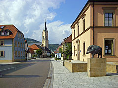
St. Nikolaus and Heimatmuseum as seen from Bahnhofstrasse, 2010
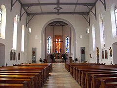
West choir of St. Nicholas Church, 2010

Nepomuk, Upper Gate

Lady Chapel

Lower Scheunenviertel, 2017

Feuerstein Observatory, 2008

railway station

64 491 of the Franconian Switzerland Steam Railway, May 2006


literature
- Johann Kaspar Bundschuh : Ebermannstadt . In: Geographical Statistical-Topographical Lexicon of Franconia . tape 1 : A-egg . Verlag der Stettinische Buchhandlung, Ulm 1799, DNB 790364298 , OCLC 833753073 , Sp. 670 ( digitized version ).
- Pleikard Joseph Stumpf : Ebermannstadt . In: Bavaria: a geographical-statistical-historical handbook of the kingdom; for the Bavarian people . Second part. Munich 1853, p. 577-578 ( digitized version ).
Web links
- City administration
- Ebermannstadt in Franconian Switzerland
- Forchheim: Ebermannstadt - St. Nikolaus and Marienkapelle
- Ebermannstadt: Official statistics of the LfStat
Individual evidence
- ↑ "Data 2" sheet, Statistical Report A1200C 202041 Population of the municipalities, districts and administrative districts 1st quarter 2020 (population based on the 2011 census) ( help ).
- ↑ Mayoress. Ebermannstadt community, accessed on June 11, 2020 .
- ^ Community Ebermannstadt in the local database of the Bavarian State Library Online . Bayerische Staatsbibliothek, accessed on May 25, 2020.
- ^ Manfred Franze: End of the war and a new beginning in Ebermannstadt and in Franconian Switzerland . Palm & Enke, Erlangen / Jena 2009, ISBN 978-3-7896-0687-8 .
- ^ Wilhelm Volkert (ed.): Handbook of Bavarian offices, communities and courts 1799–1980 . CH Beck, Munich 1983, ISBN 3-406-09669-7 , p. 451 .
- ^ Federal Statistical Office (ed.): Historical municipality directory for the Federal Republic of Germany. Name, border and key number changes in municipalities, counties and administrative districts from May 27, 1970 to December 31, 1982 . W. Kohlhammer, Stuttgart / Mainz 1983, ISBN 3-17-003263-1 , p. 683 and 684 .
- ^ [Bavarian State Office for Statistics]
- Jump up ↑ http://www.nordbayern.de/region/forchheim/ebermannstadt-nnahm-sehen-von-franz-josef-kraus-1.3615404
- ^ Entry on the coat of arms of Ebermannstadt in the database of the House of Bavarian History
- ↑ Map services of the Federal Agency for Nature Conservation ( information )
- ↑ http://www.nordbayern.de/region/forchheim/dane-braut-in-ebermannstadt-bavarian-festbeer-1.3576200?rssPage=Rm9yY2hoZWlt

Dormitz | Ebermannstadt | Effeltrich | Eggolsheim | Egloffstein | Forchheim | Gößweinstein | Graefenberg | Hallerndorf | Hausen | Heroldsbach | Hetzles | Hiltpoltstein | Igensdorf | Kirchehrenbach | Kleinsendelbach | Kunreuth | Langensendelbach | People Bach | Neunkirchen am Brand | Obertrubach | Pinzberg | Poxdorf | Pretzfeld | Lower ladder | Weilersbach | Weißenohe | Wiesenthau | Wiesenttal
Breitenbach | Buckenreuth | Burggaillereuth | Ebermannstadt | Eschlipp | Gasseldorf | Kanndorf | Moggast | Neuses | Niedermirsberg | Poxstall | Rothenbühl | Rüssenbach | Thosmühle | Windischgaillereuth | Wohlmuthshüll | Selva