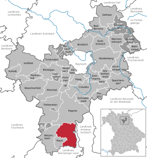
Veldenstein Forest

The Veldensteiner Forst is a forest area in the central Franconian Alb in Bavaria .
geography
The uninhabited area is in Upper Franconia in the east of the Franconian Switzerland-Veldenstein Forest Nature Park between the villages of Pegnitz in the north, Neuhaus an der Pegnitz and Plech in the south and Betzenstein in the west at an altitude of 440 to 512 m above sea level. NN . In the east it is bordered by the valley of the upper Pegnitz , in the west the route of the federal highway 9 runs .
It is named after Veldenstein Castle , a large, well-preserved medieval fortification above Neuhaus an der Pegnitz. The Veldenstein Forest with its extensive pine and spruce forests is one of the largest contiguous forest areas in Bavaria with an area of around 70 km². A large part of the Veldenstein Forest is located in the district of Bayreuth and currently forms the fourth largest Bavarian community-free area Veldenstein Forest (55.59 km²).
Attractions
The game reserve is a special attraction in the Veldenstein Forest. In the east, the Pegnitzau nature reserve between Ranna and Michelfeld borders directly on the Veldenstein Forest. In the Veldenstein Forest there are numerous rock formations, caves and sinkholes , some of which are designated as natural monuments or geotopes .
Saalburg cave
About one kilometer northeast of Viehhofen, a district of Velden , is the small karst cave Saalburghöhle on the eastern slope of the imposing rock formation Saalburg. It is about 15 meters long and registered in the Franconian Alb cave cadastre (HFA) as D 125. Rock and cave are designated by the Bavarian State Office for the Environment as geotope 472R150. See also the list of geotopes in the Bayreuth district .
Ice holes
About 2600 meters east of the Weidensees motorway exit are the Eislöcher, three collapse dolines that are connected by a 70 meter long cave passage. They owe their name to the magnificent ice formation in winter, which lasts into spring. A Befahrung is not entirely without risk. In 1969 an officer had a fatal accident there. The ice holes are identified in the HFA as D 71 and by the Bavarian State Office for the Environment as Geotope 472R083.
Big perforated stone
About 1700 meters south of Horlach is the Große Lochstein, an imposing rock tower that is traversed at the foot of a ten-meter-long through cave. The large perforated stone is listed in the HFA as D 73. It is designated as an important geotope (geotope number: 472R086) and a natural monument by the Bavarian State Office for the Environment . It was also awarded the official seal of approval for Bavaria's most beautiful geotopes by the LfU .
Small perforated stone
About 2800 meters east of the Weidensees motorway exit is the small Lochstein, a rocky knoll that is criss-crossed by a short through cave. The small perforated stone is identified in the HFA as D 72 and by the Bavarian State Office for the Environment as Geotope 472R085.
fauna and Flora
The area consists of mixed forest and offers a habitat for species-rich floral communities as well as wild populations. About a third of the Bavarian hunting bag of deer is killed in Veldenstein Forest.
Since the beginning of the 2010s, the Veldenstein Forest was also considered a Wolferwartung area. First, only certain individuals have been spotted, from that on the neighboring Grafenwoehr Training Area -based pack should be migrated. As early as 2016/17, genetic analyzes of wild animal cracks brought certainty and since the beginning of 2018 it was assumed that a pair would be formed. At the beginning of March 2018, a pair of wolves was confirmed by traces on a game tear. In September 2019 it became known through recordings from wildlife cameras that the pair of wolves, which had become at home in the Veldenstein Forest, had successfully reared four young animals for the second time.
Individual evidence
- ↑ Veldenstein Forest on Bavaria Atlas
- ↑ Area information at www.destatis.de, as of December 31, 2018 , accessed on August 1, 2020.
- ↑ Geotope: The Saalburg with caves D125 (accessed on October 2, 2013; PDF; 188 kB)
- ↑ Geotope: collapse dolines ice holes D71 (accessed on October 2, 2013; PDF; 187 kB)
- ^ Bavarian State Office for the Environment, geotope "Großer Lochstein" SSW von Horlach (accessed on November 28, 2017).
- ↑ Bavaria's most beautiful geotopes, Großer Lochstein (accessed on November 28, 2017)
- ↑ Geotope: Small hole stone with cave ruins D72 (accessed on October 4, 2013; PDF; 193 kB)
- ↑ Veldenstein Forest Hunting Grounds
- ↑ Wolves in Germany on Google Maps
- ↑ Press report Nordbayern.de, Wolf cracks on three wildlife
- ↑ Press report Nordbayern.de, Wolf Couple in Velden Forst
- ^ Press report Nordbayern.de of March 8, 2018
- ↑ Press report Nordbayernd.de from Sept. 21, 2019
literature
- Stephan Lang: Höhlen in Franken - A hiking guide into the underworld of Hersbrucker Switzerland and the Upper Palatinate Jura . Hans Carl Verlag, Nuremberg 2006, ISBN 3-418-00390-7 , pp. 36-38.
Web links
Coordinates: 49 ° 41 ′ 4 ″ N , 11 ° 31 ′ 9 ″ E


