
Pegnitz (river)
| Pegnitz | ||
 The Pegnitz as the southern and eastern boundary of Franconian Switzerland |
||
| Data | ||
| Water code | EN : 2422 | |
| location | Bavaria | |
| River system | Rhine | |
| Drain over | Regnitz → Main → Rhine → North Sea | |
| source | at Pegnitz from the Pegnitz spring 49 ° 45 ′ 29 ″ N , 11 ° 32 ′ 16 ″ E |
|
| Source height | 426 m above sea level NN | |
| Spring discharge |
MQ |
5 l / s |
| confluence | Northwest of the old town of Fürth with the Rednitz to Regnitz Coordinates: 49 ° 29 '12 " N , 10 ° 59' 12" E 49 ° 29 '12 " N , 10 ° 59' 12" E |
|
| Mouth height | 282 m above sea level NN | |
| Height difference | 144 m | |
| Bottom slope | approx. 1.3 ‰ | |
| length | approx. 112.8 km | |
| Catchment area | 1,230.32 km² | |
| Discharge at the Nuremberg Lederersteg A Eo gauge: 1,197.58 km² Location: 6.47 km above the mouth |
NNQ (-) MNQ 1911/2012 MQ 1911/2012 Mq 1911/2012 MHQ 1911/2012 HHQ (1909) |
3.48 m³ / s 6.76 m³ / s 11.5 m³ / s 9.6 l / (s km²) 59.4 m³ / s 370 m³ / s |
| Left tributaries | Fichtenohe , Flembach, Hirschbach, Högenbach , Happurger Bach, Hammerbach, Sandbach, Röthenbach , Goldbach | |
| Right tributaries | Sittenbach , Schnaittach , Röttenbach, Bitterbach , Tiefgraben | |
| Reservoirs flowed through | Wöhrder See | |
| Big cities | Nuremberg , Fürth | |
| Medium-sized cities | Run on the Pegnitz | |
| Small towns | Pegnitz , Hersbruck , Röthenbach an der Pegnitz | |
 While the Pegnitz needs about 15 minutes to "flow around" the water mountain, the underground flow takes about 180 minutes |
||
The Pegnitz is a river in Franconia that joins the left Rednitz to the Regnitz after an almost 113 km long, altogether south-westerly run in Fürth . On the Fließweg with its longer and more watery upper course Fichtenohe it is over 127 km long.
Name interpretation
The river name Pegnitz goes back to the name “Paginza” from 889 and is seen as a derivative with an -nt- suffix to Indo-European bhog- = flowing water. In 1119, when the town of Pegnitz was first mentioned in a document, it can be found as "Begenze" and in 1196 as "Begnitz", before the current name was mentioned in 1329. In Franconia it is also often called "Bengertz".
geography
Source and upper course
The source of the Pegnitz is located in the town of Pegnitz on the eastern slope of the Schloßberg (543 m above sea level): The water of the Pegnitz flows through the Pegnitz city area from a karst spring located on this mountain at an altitude of 425 m . The majority of the Pegnitz water there does not come from this source, however, but rises in the Lindenhardt Forest as Fichtenohe, which flows in the direction of Pegnitz and flows into the short stream from the Pegnitz spring in the urban area.
Fichtenohe

The Fichtenohe is an approx. 14.7 km long left tributary of the Pegnitz, which is only about a hundred meters long at the confluence. Some also count the Fichtenohe as part of the Pegnitz and see this name only as a secondary name for the upper reaches of the Pegnitz. It rises in the Lindenhardt Forest north of Lindenhardt near the A 9 . From there it flows steadily to the south and divides into two arms in Pegnitz. Although the right arm of the Fichtenohe, which flows into the Pegnitz, which is only a few meters long, already appears quite stately in Pegnitz and exceeds this in the water flow, the stream is called Pegnitz from there ( 49 ° 45 ′ 26.3 ″ N , 11 ° 32 ′ 17, 7 ″ O ).
Craimoos pond
The Craimoosweiher is a nearly 15 hectares large pond , which is on the watershed is the Main and Pegnitz. The water from the protected Craimoosweiher flows both north into the Red Main and south over the Weihergraben towards Pegnitz. This makes the pond not only a hydrographic specialty, but also the origin of a circle that ultimately closes again when the Regnitz flows into the Main - a water bifurcation that is quite rare in Europe .
Stream crossing
Another special feature is a so-called brook crossing in a small park in Pegnitz, the Wiesweiher. There, the left arm of the Fichtenohe, the Mühlbach, which has emerged from the division, crosses under the Pegnitz flowing straight ahead (i.e. its former right arm) with the help of a culvert from north to south and flows on to the Wasserberg.
Underground flow

At the natural monument “Underground Flow”, the Pegnitz flows around the water mountain in a wide arc, while the Fichtenohe at the Röschmühle disappears into the mountain. After 320 meters as the crow flies, the river emerges again on the southern slope of the mountain and finally turns towards the Pegnitz. How the Fichtenohe flows within the mountain is unknown. However, tests with colored water have shown that it takes about twelve times as much time on its winding paths through the subterranean rock fissure as the Pegnitz above ground. The discharge at the re-outlet has since decreased considerably, at the turn of the century the water on the southern slope of the water mountain gushed even more powerfully from the limestone. In addition to this main exit point, four to six other small pseudo springs are known, which can be observed especially during floods after thunderstorms.
River course
The Pegnitz flows in a southerly direction via Neuhaus and Velden through the Franconian Switzerland-Veldenstein Forest Nature Park and then through Hersbrucker Schweiz via Hersbruck . Then it runs in a westerly direction via Lauf and Nuremberg to Fürth . To the north of Fürth city center, it joins the Rednitz to the Regnitz at an altitude of 283 meters .
Tributaries
Table with larger tributaries, from the origin to the mouth. River code number GKZ for better readability with separator after the common prefix 2422, the GKZ of the Pegnitz itself. Length including the main line upstream sequence.
| Name (section name , upwards) | GKZ | Length [km] |
EZG [km²] |
from | Mouth | comment |
|---|---|---|---|---|---|---|
| Fichtenohe | 2422 | 14.7 | Left | Pegnitz | Local name Fichtenohe, main name Pegnitz. | |
| Flembach | 2422-2 | 18.58 | 87.95 | Left | Auerbach in the Upper Palatinate , Michelfeld district | Only a short underflow Flembach after the confluence of the Fenkenwaldbach and Goldbrunnenbach. |
| Hirschbach (Oberlaufname Wildbach) | 2422-32 | 13.64 | 55.36 | Left | Pommelsbrunn , district of Eschenbach . | |
| Högenbach | 2422-4 | 20.55 | 112.90 | Left | Pommelsbrunn | |
| Happurger Bach (Alfelder Bach) | 2422-52 | 17.08 | 89.62 | Left | Happurg | |
| Sittenbach | 2422-54 | 12.07 | 42.47 | right | Hersbruck , Altensittenbach district | |
| Hammerbach | 2422-56 | 13.64 | 40.51 | Left | Henfenfeld | with left main upper course Herrnbach |
| Sandbach (Sendelbach, Hopfengraben) | 2422-58 | 6.14 | 12.88 | Left | Reichenschwand | |
| Schnaittach (Naifer Bach) | 2422-6 | 17.40 | 79.83 | right | Ottensoos / Neunkirchen am Sand border | |
| Nessenbach (Gänsegraben) | 2422-72 | 6.05 | 9.55 | Left | Neunkirchen am Sand , opposite. | |
| Rottenbach | 2422-74 | 12.93 | 29.95 | right | Neunkirchen am Sand | |
| Himmelbach (Bodengraben) | 2422-76 | 3.52 | 7.89 | Left | Run on the Pegnitz | |
| Bitterbach (Teufelsgraben) | 2422-78 | 6.91 | 18.66 | right | Run on the Pegnitz | |
| Roethenbach | 2422-8 | 20.99 | 80.20 | Left | Röthenbach on the Pegnitz | |
| Schneidersbach (Zweibrücklesgraben) | 2422-92 | 8.18 | 12.62 | Left | Nuremberg-Laufamholz | |
| Langwassergraben | 2422-932 | 7.98 | right | Nuremberg-Erlenstegen | ||
| Dig deep | 2422-94 | 3.43 | 10.66 | right | Nuremberg-Erlenstegen | |
| Goldbach (Hutgraben, Rehgraben) | 2422-96 | 10.35 | 59.24 | Left | Nuremberg-Wöhrd |
Cities on the Pegnitz


From the source to the mouth:
- Pegnitz
- Velden an der Pegnitz
- Hersbruck
- Run on the Pegnitz
- Röthenbach on the Pegnitz
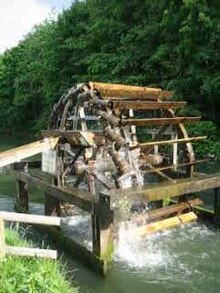
- Nuremberg : In the urban area (approx. 14 km) the river forms tributaries. In the eastern part of the city, the river to Wöhrder See is dammed. Numerous bridges and footbridges cross the water ; u. a. the iron suspension bridge ( Kettensteg ) from 1824. West of the Maxbrücke there is a weir. In the western part of the city, the river was renatured in several sections from 1998 to 2001 ; it was based on the historic river bed . A bucket wheel based on a historical model was also rebuilt there.
- Fürth: There are numerous bridges and footbridges. As part of the Uferstadt Fürth project (conversion of the former Grundig company headquarters into a business park), the river was laid in a natural bed in the eastern part of the city in 2003; Two new loops and flattened banks have been created over a length of one kilometer. Part of the former river bed was retained as an oxbow lake. This measure was co-financed by the European Union .
history
At least since the Middle Ages, the Pegnitz has been an important economic artery for the region. The abundance of fish served to provide food and water power was used to drive the mills. In 1390 Ulmann Stromer converted the Gleißmühle at Pegnitz into the first paper mill north of the Alps , the Hadermühle ( hadern = rags).
After the great flood in February 1909 (with a discharge of 370 m³ / s) the river was shortened by about four kilometers through straightening in the Nuremberg city area.
Since 1996, plans and measures have been underway to lengthen the course of the river between Nuremberg and Fürth by looping it again and thus make it natural.
Education and leisure
To the east of Nuremberg's core city between Mögeldorf and Hammer near Laufamholz , the Nuremberg Water Management Office has set up the Pegnitztal-Ost nature experience trail with over 20 stations.
The Pegnitz has few rapids and barrages and some sections can be traveled by canoe and kayak. Since 2012, the Pegnitz in the western urban area of Nuremberg has been allowed to travel again with small, non-propelled watercraft from the Lederersteg. The traffic ban in the city center is still valid for safety reasons (e.g. impassable weirs without the possibility of transferring, high embankment walls).
The Pegnitztal Cycle Path runs from Hersbruck and Hohenstadt on a stretch of about 30 km in the upper and middle Pegnitz Valley.
Lists and related topics
Picture gallery

Pegnitz and Heilig-Geist-Spital in Nuremberg
The young Pegnitz, after the mouth of the right arm of the Fichtenohe in Pegnitz

The left arm of Fichtenohe in Pegnitz

The stream crossing of Fichtenohe and Pegnitz
The inlet of the Fichtenohe into the water mountain

The re-emergence of the Fichtenohe from the water mountain

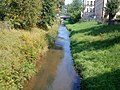
The Pegnitz near Düsselbach


literature
- Johann Kaspar Bundschuh : Pegnitz . In: Geographical Statistical-Topographical Lexicon of Franconia . tape 4 : Ni-R . Verlag der Stettinische Buchhandlung, Ulm 1801, DNB 790364301 , OCLC 833753101 , Sp. 316-318 ( digitized version ).
- Herbert Liedel, Helmut Dollhopf: The Pegnitz. Moments of a river. Stürtz, Würzburg 1982, ISBN 3-8003-0190-3 .
- Irene Reif : What one 's Isar - is the other' s Pegnitz. A Pegnitz legend. In: Franconia - my love. Oberfränkische Verlagsanstalt, Hof 1989, ISBN 3-921615-91-7 , pp. 185f.
- 10 years of the Pegnitz fishing community: 1981–1991. Fishing community Pegnitz, Lauf 1991.
- Alfons Baier, Abdul Hanan Roostai, Jan Schwope: Karst hydrogeological investigations on the Wasserberg near Pegnitz (Upper Franconia). In: Geological sheets for northeast Bavaria and neighboring areas. 44,1-2, 1994, pp. 15-102, Geozentrum Nordbayern, Erlangen 1994 ISSN 0016-7797
- Max Schäfer: The most beautiful hikes to the right and left of the Wiesent / Max Schäfer. [Watercolors: Oskar Koller. All photos: Max Schäfer. Hiking sketches: Tilman Zitzmann] 3., updated, redesigned and heavily ext. Edition. Fahner, Lauf an der Pegnitz 1996, ISBN 3-924158-29-0 .
- Max Schäfer: Highlights on the right and left of the Pegnitz; with the VGN ticket in the backpack bag . Fahner, Lauf 2001, ISBN 3-924158-58-4 .
- Dieter Piwernetz (Ed.): The Pegnitz: a reference work for fishermen and nature lovers and commemorative publication on the occasion of the 20th anniversary of the "Fischerei - Hegegemeinschaft Pegnitz". Korn and Berg, Nuremberg 2002, ISBN 3-87432-210-6 .
- Ewald Glückert: City and River - Lauf and the Pegnitz . Ziethen, Oschersleben 2003, ISBN 3-935358-64-4 .
- Franz X. Bogner: The Pegnitz in an aerial portrait . Ellwanger, Bayreuth 2009, ISBN 978-3-925361-74-6 .
Individual evidence
- ↑ a b Height queried on: BayernAtlas of the Bavarian State Government ( information ) (right-click)
- ↑ a b According to the list of brook and river areas in Bavaria - Main river area, page 41 of the Bavarian State Office for the Environment, as of 2016 (PDF; 3.3 MB) and length measurement of the section of water from the inflow of the Erlbach into the Fichtenohe to the confluence with the outflow of the Pegnitz spring as well as its own length, both on: BayernAtlas of the Bavarian State Government ( references )
- ↑ a b List of brook and river areas in Bavaria - Main river area, page 41 of the Bavarian State Office for the Environment, as of 2016 (PDF; 3.3 MB)
- ↑ Flood news service of the Bavarian State Office for the Environment ( information ) (as of October 27, 2015)
- ↑ Photo of the stream crossing at panoramio.com
- ↑ Karst hydrogeological investigations on the Wasserberg near Pegnitz (Upper Franconia)
- ↑ Directory of creek and river areas in Bavaria - Main river area, page 41 of the Bavarian State Office for the Environment, as of 2016 (PDF; 3.3 MB) (up to page 46)
- ↑ Length up to the confluence of the former right arm into the Pegnitz. The left, which flows further down, shortens a right loop of the valley on an open section and is therefore only about 400–500 meters longer, plus the underground section through the water mountain of at least another 400 meters.
- ↑ The path can be viewed in OpenStreetMap under Openstreetmap: Naturerlebnispfad Pegnitztal-Ost
- ↑ Press Office Nuremberg: Boating allowed on the Pegnitz in future ( Memento of the original from August 3, 2012 in the Internet Archive ) Info: The archive link was inserted automatically and has not yet been checked. Please check the original and archive link according to the instructions and then remove this notice.
Web links
- Pegnitz: flood risk management plan , water system , flood characteristics , flood events , government of Lower Franconia
- Water Management Office Nuremberg: "The redesign of the Pegnitz in Nuremberg"
- Karst hydrogeological investigations on the Wasserberg near Pegnitz (Upper Franconia) , short version by: BAIER, A., ROOSTAI, A. & SCHWOPE, J. (1994): Karst hydrogeological investigations on the "Wasserberg" near Pegnitz (Upper Franconia) .- Geol. Bl. NO- Bayern 44, 1/2: 15-102, 26 figs., 6 tab., 2 plate, Erlangen 1994.