Fils (river)
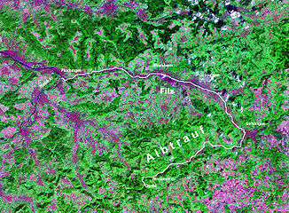
The Fils is a 63 kilometer long, right and eastern tributary of the Neckar in Baden-Württemberg (Germany). Their upper valley is locally called valleys , which is reflected in the addition of some names of valley locations. In its middle and lower course, between Geislingen and Plochingen , the Filstal is an almost continuously populated and largely industrialized valley.
etymology
It has long been assumed that the name Fils belongs to a pre-Roman name layer. Numerous bodies of water that were found in particular near Göppingen and Uhingen (axes, swords) - as they are also known from numerous other rivers - date back to the Bronze Age and could go back to cultic landfill. More recently, another derivation has been favored: The first mention as the eponymous part of Filsgau ("Filiuuisgouwe") suggests an original form of the name * Filiwisa (with "uu" as the spelling for "w"), and thus a derivation from Old High German * filiwa ( Felbe = willow tree). This would explain the name as a “willow-lined river”.
geography
course
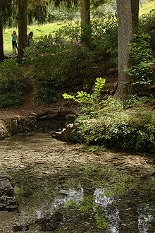
The Fils rises in the Swabian Alb around two kilometers southwest of the city of Wiesensteig . Your karst source , the Filsursprung , is 624.9 m above sea level. NN in Hasental, which has remained close to nature. There are two more springs a little further down, the Kleiner Filsursprung on the right and the Hasenquelle on the left at the foot of the slope.
The young river runs through - initially running in a north-easterly direction - after Wiesensteig the community of Mühlhausen im Täle , where the Hollbach flows on the left and the A 8 crosses the valley. Then Gosbach follows with the mouth of the Gos on the right. In Bad Ditzenbach the Hartel flows into the river from the left and the Ditz from the right . In Deggingen , the longer Schinderbach flows into the Fils from the left and the short Sennenbach and Schüttebach from the right. The Fischbach flows into the lower valley at Reichenbach im Täle and the Rohrbach flows into Hausen an der Fils . In Bad Überkingen , the Rötelbach coming from the right allows the Fils to grow further. The Filstal describes a 90-degree curve to the left through Geislingen an der Steige , in the course of which the Eyb flows from the northeast .
The Eyb is the first longer tributary from the right-hand side, which also has a richer catchment area on the surface, after the streams tapering from the left from the crumpled inside of the Alb eaves have regularly exceeded their counterparts on the edge of the flat Alb plateau in both properties. Before the mouth, the Eyb takes in a northwest-running tributary from Amstetten, which is why Geislingen lies in a wide valley spider . From then on, the Fils also runs in a north-westerly direction through its exit bay from the Alb into the Swabian Keuper-Lias-Land , in which Kuchen and then at the inflow of the Marrbach Gingen are located. In the meantime, in front of the Alb, the right Lauter , the largest tributary of the Fils at all, flows into Süßen on its west-south-western course. From here the Fils runs approximately to the west at a steadily increasing distance from the edge of the Alb steps to the left, which is why the left and right tributaries become more similar in length and catchment area.
In the now wide valley follow Salach , Eislingen with the Krumm from the right, the second largest tributary of the Fils, and the left Weilerbach, then Göppingen , Faurndau with the Marbach (right), Uhingen with the Blaubach (right), the Butzbach (left) and the Nassach (right). The third from last village on the river is Ebersbach an der Fils , where the eponymous Ebersbach joins from the right as does the following Kirnbach just before the municipality and district border with Reichenbach an der Fils . Reichenbach and Lützelbach flow into this place from the right and finally the Talbach from opposite.
Then reached the Fils Plochingen , where they at 248.3 m above sea level. NN after about 63 kilometers and almost 377 meters in altitude below its source flows from the right into the left curve of the Neckar there ; it has an average bottom slope of about 6 ‰. Its catchment area covers around 707 km². It is the fifth largest in terms of length and the fourth largest in terms of its catchment area.
Catchment area
The 707 km² catchment area of the Fils is naturally almost completely divided into a slightly smaller southern part in the Swabian Alb and a slightly larger northern part in the foothills of the Alb. Initially, the river runs approximately east-northeast until it turns from Geislingen through the Mittlere Kuppenalb and towards the end it also has a tributary from the Albuch and Härtsfeld in the east. From Geislingen it turns slowly westwards and flows through the three sub-areas Filsalbvorberge , Notzinger Platte and Schlierbacher Platte of the Middle Alb foreland , whereby the right tributaries first drain the Rehgebirge of the Eastern Alb foreland and then the southern part of the Schurwald in the Swabian Keuper-Lias-Land . A tiny gusset near the mouth of the river near Plochingen lies in the Nürtinger-Esslinger Neckar Valley , a part of the Filder region that is part of the same large landscape upstream of the Alb foreland .
Tributaries of the Fils
The ten longest

The ten richest catchment areas

Flood
The highest registered flood of the Fils so far was registered at Plochingen with a runoff of 379 m³ / s on May 7, 1931, followed by the floods in March 1956 (approx. 350 m³ / s), in April 1994 (352 m³ / s ), in October 1998 (308 m³ / s), in March 2002 (285 m³ / s), in January 2004 (351 m³ / s) and in June 2013 (326 m³ / s). Of the seven highest Fils floods since 1931, five have flowed in the last 20 years. Previously, floods on October 29, 1829, May 12, 1853, December 27, 1882, May 20, 1906 and December 24, 1919 have been reported.
The flood of 1853 killed around 40 people in the Göppingen district and around 200 cattle perished. In Uhingen and Ebersbach, the then new bridges were torn away. In Faurndau the water was over 4 feet high in the church. The new Filstalbahn was damaged near Eislingen.
However, floods also occurred on the Fils in earlier times. The place name Faurndau refers to the special risk of flooding, which may have been particularly great here due to the valley gorge and the flowing streams of Brunnenbach and Marbach. Bronze Age finds from the gravel of the Fils could also be indications of floods - if it is not a ritual landfill. Soil studies at the town hall in Göppingen showed that an oxbow lake of the Fils there fell dry due to the progressive incision of the river during the Bronze Age.
The floods are usually caused by rain events, while the snowmelt effect is greatly mitigated by the Alb karst, at least in the upper reaches. The straightening of the Fils and many of their tributaries increase the effect of the floods. Shortly before the floods in 1935, extensive straightening and regulation between Süßen and Reichenbach had been carried out in 1934 as part of job creation measures.
Floods occur in all seasons. In summer, the Fils has little water after long periods of precipitation-free. However, there has never been a complete dehydration.
nature and environment
Water quality
Because the Fils has been flowing through an area that has been heavily industrialized since the beginning of the 20th century, it was heavily polluted for decades with sewage from households, and even more so from the chemical and leather processing industry , as well as bleaching and dyeing works.
In the period between the 1940s and the mid-1980s, the wastewater was discharged largely untreated directly, which led to red, blue or purple discoloration. In the 1960s and 1970s, the proportion of chemical wastewater increased so that there was no longer any life in the Fils. During this time there was a ban on people not being allowed to "enter" or drink the water.
The situation has improved a lot since the mid-1980s. Due to new environmental guidelines, many factories had to be stopped, sewage treatment plants were built and animal species were resettled in the Fils. However, the banks and the ground are still heavily contaminated with heavy metals . The banks are built over long stretches, which is why attempts are being made in some places to bring the Fils back to life as a river.
Fish species
The Fils is home to typical trout fish . The following types of fish are proven to be represented: rainbow trout , brown trout , char , barbel , gudgeon , minnow , chub , stickleback , Mühlkoppe , loach (isolated: grayling , perch , carp )
water sports
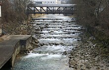
The Fils is only suitable for water sports in the upper area from Mühlhausen to Altenstadt and in the lower reaches from Göppingen, in the upper reaches only for experienced whitewater riders with suitable water levels. In the middle reaches, because of the many weirs and the associated dangers, it is not recommended to drive on them.
history
The lower and middle Filstal have been an important east-west traffic axis since prehistoric times. A Roman road ran here (see also: Kastell Eislingen-Salach ). In the early Middle Ages, an apparently powerful aristocratic family settled near Geislingen, mainly because of them. Hungarian finds from Eislingen and Schlat indicate that it was also used during an advance of the Hungarian storms of the 10th century. Fords at Süßen, Göppingen and Faurndau were connected to north-south connections that crossed the Fils.
Today the Filstalbahn and the federal road 10 to Geislinger Steige run here .
Attractions
Sights on the Fils and in the valley area, in the direction of flow:
- The Filsursprung is in Hasental, about 2 km southwest of Wiesensteig
- The 232 meter long Schertelshöhle is located above the Filsursprings
- To the right above Deggingen is the Ave Maria pilgrimage church
- The ruins of Staufeneck Castle and Ramsberg Castle are on the right near Süßen
- In Gingen an der Fils (11 km east of Göppingen), there is the Johanneskirche with what is probably the oldest church inscription in Germany
- At the end of the middle reaches Göppingen , the largest city on the river, with the Staufer exhibition and local history museum
- Faurndau follows on the left with its Romanesque collegiate church (13th century)
- The Castle Filseck faces Uhingen left above the valley
See also
literature
- Jürgen Hagel: The Filstal. Nature, culture, history, places. Silberburg-Verlag , Tübingen 2003, ISBN 3-87407-564-8 .
- Margret Hofheinz-Döring : Sunday trip around the Filstal. Self-published, Zell u. A. 1979, DNB 930925971 . (drawn views of almost all places on the Fils, with text contributions)
- R. Pantle: The waters of the district . In: Heimatbuch des Landkreis Göppingen. Göppingen 1956, pp. 53-63.
- H. Smettan: What the pollen under the Göppingen town hall reveals . In: Hohenstaufen & Helfenstein. Volume 2, Konrad, Weissenhorn 1992, ISBN 3-87437-337-1 , pp. 9-20.
- Rainer Schreg : Archaeological finds from the Fils. An example of the problem of water finds in prehistory and the Middle Ages . In: Hohenstaufen & Helfenstein. Volume 2, Konrad, Weissenhorn 1992, ISBN 3-87437-337-1 , pp. 21-46.
- Lutz Reichardt: Place name book of the district of Göppingen . Kohlhammer, Stuttgart 1989, ISBN 3-17-009885-3 .
Individual evidence
LUBW
Official online waterway map with a suitable section and the layers used here: Map of the course of the Fils and their catchment area
General introduction without default settings and layers: State Institute for the Environment Baden-Württemberg (LUBW) ( notes )
- ↑ a b Height according to the blue lettering on the background layer of the topographic map .
- ↑ Length according to the waterway network layer ( AWGN ) .
- ↑ Catchment area after the layer aggregated areas 04 .
Other individual evidence
- ↑ a b c Ministry for the Environment, Climate and Energy Baden-Württemberg: Expansion potential of hydropower up to 1,000 KW in the Neckar catchment area, taking into account ecological management goals ( memento of the original from October 29, 2013 in the Internet Archive ) Info: The archive link was automatically inserted and not yet checked. Please check the original and archive link according to the instructions and then remove this notice. , 2011, p. 9, ab. on June 29, 2013 (pdf, German, 1.87 MB).
- ^ German Hydrological Yearbook Rhine Region, Part I 2009 State Institute for Environment, Measurements and Nature Conservation Baden-Württemberg, p. 116, accessed on January 22, 2016 (PDF, German, 1.85 MB).
- ^ Lutz Reichardt: Place name book of the district of Göppingen , 1989.
- ↑ Hansjörg Dongus : Geographical land survey: The natural spatial units on sheet 171 Göppingen. Federal Institute for Regional Studies, Bad Godesberg 1961. → Online map (PDF; 4.3 MB)
- ↑ Note: level Süßen min. 0.70 m, the level of difficulty increases rapidly as the level rises. River description Fils In: Hubert Speck: Canoe guide Württemberg. Duisburg 2005, ISBN 3-924580-99-5 .
literature
- Topographic map 1: 25,000 Baden-Württemberg, as a single sheet No. 7222 Plochingen, No. 7223 Göppingen, No. 7224 Schwäbisch Gmünd Süd, No. 7225 Heubach, No. 7322 Kirchheim unter Teck, No. 7323 Weilheim an der Teck, No. 7324 Geislingen an der Steige West, No. 7325 Geislingen an der Steige Ost, No. 7423 Wiesensteig, No. 7424 Deggingen and No. 7425 Lonsee
Web links
- Map of the course and catchment area of the Fils on: State Institute for the Environment Baden-Württemberg (LUBW) ( information )
- Map of the course and catchment area of the Fils on: Geoportal Baden-Württemberg ( information )
- Measuring table sheet 7222 Plochingen from 1927 in the Deutsche Fotothek
- Measuring table sheets in the Deutsche Fotothek :
- 7222 Plochingen from 1927
- 7223 Göppingen from 1935
- 7224 Lorch from 1937
- 7225 Heubach from 1928
- 7322 Kirchheim unter Teck from 1905
- 7323 Weilheim an der Teck from 1905
- 7324 Altenstadt from 1933
- 7325 Geislingen an der Steige from 1925
- 7423 Wiesensteig from 1905
- 7424 Deggingen from 1904
- 7425 Weidenstetten from 1926


