Eyb (river)
| Eyb | ||
|
Eybquelle |
||
| Data | ||
| Water code | DE : 23822 | |
| location |
Albuch and Härtsfeld
|
|
| River system | Rhine | |
| Drain over | Fils → Neckar → Rhine → North Sea | |
| source | on the southern edge of Böhmenkirch- Treffelhausen next to the road to Geislingen 48 ° 41 ′ 12 ″ N , 9 ° 53 ′ 34 ″ E |
|
| Source height | approx. 600 m above sea level NHN | |
| muzzle | from the left in Geislingen-Altenstadt to the middle Fils coordinates: 48 ° 37 '46 " N , 9 ° 48' 50" E 48 ° 37 '46 " N , 9 ° 48' 50" E |
|
| Mouth height | 408.5 m above sea level NHN | |
| Height difference | approx. 191.5 m | |
| Bottom slope | approx. 15 ‰ | |
| length | 12.8 km | |
| Catchment area | 108.807 km² | |
| Communities | Böhmenkirch , Geislingen an der Steige | |
The Eyb is a small river almost 13 km long in the western Albuch in the Baden-Württemberg district of Göppingen , which flows from the right into the upper Fils in the Altenstadt district of Geislingen an der Steige after a sweeping left and generally southwest .
geography
course
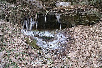
The Eyb rises a little away from the southern outskirts of the village of Treffelhausen in Bohemia . The first 50 meters of the river bed are artificially expanded and lined. A few meters from the source is the 18 meter long Eybquellenhöhle, on the opposite side of the valley is the 8 meter long hard cave. Both the Eyb spring and the two caves are designated natural monuments .
The Eyb initially flows southwards through the Roggental for a long time , passing the Mordloch karst cave on the right lower slope, from which a spring stream named Mühlbach emerges, which then runs a little way next to it. Then she reaches the historic Böhmenkircher Oberen Roggenmühle , in which water power has driven a grinder for centuries; later electricity was generated here until 1962. The spring water from the murder hole fills the trout ponds in front of the mill, especially after long rain and when the snow is melting. At the end of the mill, which is now a restaurant, the Mühlbach flows into the Eyb.
From less than a kilometer further down standing Lower rye mill the Eyb flows through you now Eybachtal called Kerbsohlental in the Swabian Alb southwest on the Geislingen district Eybach to and at the city's castle over. In this section the valley filling is determined by freshwater limestone ( tufa limestone ). In the adjoining Geislingen itself, it reaches the southernmost point of its course, and the Rohrach , coming from the south, flows close by , which contributes almost as much to its catchment area as the Eyb itself up to this point Geislinger Talspinne and flows into the Fils in the Altenstadt district from the right at the beginning of its large west bend.
The 12.8 km long Eyb and falls on its course by about 190 meters in altitude, so it has an average bottom gradient of about 15 ‰. In its 109 km² catchment area on the karst Alb, there are hardly any above-ground watercourses except in the deep valleys of its few large inlets, but in addition to the above-mentioned murder hole there are other sources at the edge of the valley cuts from the karst aquifer.
The Eyb flows for a long time in the nature reserve Eybtal with parts of the Längen- and Rohrachtal , which on the populated lower reaches the valley only from both feet of the slope upwards.
Tributaries
From the source to the mouth. Selection. In addition, numerous dry valley runs.
- Magentalbach , from the left near Geislingen an der Steige - Untere Roggenmühle
- (Stream from the rye riser ), from the left to the lower rye mill
- Längentalbach , from the right in Geislingen- Eybach
- Siebenquellenbach , from the left in Geislingen
- Talgrabenbach , from the right in Geislingen
- Rohrach , from the left in Geislingen
Individual evidence
- ↑ Hansjörg Dongus : Geographical land survey: The natural spatial units on sheet 171 Göppingen. Federal Institute for Regional Studies, Bad Godesberg 1961. → Online map (PDF; 4.3 MB)
- ↑ a b c d State Institute for the Environment Baden-Württemberg (LUBW) ( information )
literature
- Topographic map 1: 25,000 Baden-Württemberg, as single sheet No. 7224 Schwäbisch Gmünd Süd, No. 7324 Geislingen an der Steige West and No. 7325 Geislingen an der Steige Ost
Web links
- Internet presence of the city of Geislingen
- Website of the municipality of Böhmenkirch
- Map of the course and catchment area of the Eyb on: State Institute for the Environment Baden-Württemberg (LUBW) ( information )
- Map of the course and catchment area of the Eyb on: Geoportal Baden-Württemberg ( information )
- Measuring table sheets in the Deutsche Fotothek :
- 7225 Heubach from 1928
- Measuring table sheet 7324 Altenstadt from 1933
- 7325 Geislingen an der Steige from 1925
