
Neckar
| Neckar | ||
 Course of the Neckar |
||
| Data | ||
| Water code | EN : 238 | |
| location |
Germany Baden-Wuerttemberg Hesse |
|
| River system | Rhine | |
| Drain over | Rhine → North Sea | |
| Headwaters |
designated: Schwenningen , Möglingshöhe City Park according to LUBW-FG10 (polygon course): southern Schwenninger Moos 48 ° 2 ′ 42 ″ N , 8 ° 31 ′ 42 ″ E |
|
| Source height | approx. 705 m above sea level NN in the south of Schwenninger Moos |
|
| muzzle | near Mannheim from the right and finally southeast in the Rhine coordinates: 49 ° 30 '42 " N , 8 ° 26' 15" E 49 ° 30 '42 " N , 8 ° 26' 15" E |
|
| Mouth height | approx. 88 m above sea level NN | |
| Height difference | approx. 617 m | |
| Bottom slope | approx. 1.7 ‰ | |
| length | 362.3 km from Q. in southern Schwenninger Moos |
|
| Catchment area | 13,934 km² | |
| Drain at the Rottweil gauge |
MQ |
5.36 m³ / s |
| Drainage at the Gundelsheim gauge |
MQ |
88.2 m³ / s |
| Discharge at the Rockenau SKA A Eo gauge : 12,710 km² Location: 60.7 km above the mouth |
NNQ (07/04/1976) MNQ 1951/2009 MQ 1951/2009 Mq 1951/2009 MHQ 1951/2009 HHQ (12/21/1993) |
18.4 m³ / s 36.5 m³ / s 136 m³ / s 10.7 l / (s km²) 1170 m³ / s 2690 m³ / s |
| Drain at the Mannheim gauge |
MQ |
145 m³ / s |
| Big cities | Reutlingen , Stuttgart , Heilbronn , Heidelberg , Mannheim | |
| Ports | Plochingen, Stuttgart , Heilbronn, Mannheim | |
| Navigable | 203 km from the mouth to Plochingen for large motor cargo ships |
|
 The Neckar near Heidelberg |
||
The Neckar is a tributary of the Rhine in Germany with a length of 362 km - with the longer upper reaches Eschach even 380 km - which drains the central part of Baden-Württemberg with its 14,000 km² catchment area . At its mouth, an average of 145 m³ / s flow off. From a hydrological point of view, the Neckar is the fifth largest tributary of the Rhine after the Aare , Maas , Mosel and Main, and the twelfth largest river in Germany in terms of length and water flow.
The Neckar rises on the Baar near Villingen-Schwenningen at 705 m above sea level. NN . First it flows northeast between the Black Forest and the Swabian Alb , from the "Neckarknie" at Plochingen north-west to north through the metropolitan areas of Stuttgart and Heilbronn , then from Eberbach in the Odenwald west to Heidelberg and finally in the Upper Rhine Plain north-west to Mannheim . Here ⊙ it flows into the Rhine at 88 m above sea level. Its three largest tributaries are the Enz , the Kocher and the Jagst .
The Neckar is Plochingen down by impoundments for Großschifffahrtsweg ( federal waterway removed) with major ports in Stuttgart , Heilbronn and Mannheim .
Due to straightening , embankments and other things, the water structure and the flow dynamics of the former natural river have suffered greatly and the structured floodplain landscapes have often disappeared. In the meantime, some sections of the backwater (Altneckar) have been renatured, and the water quality has improved considerably since the 1970s.
The Neckar flows almost exclusively through Baden-Württemberg. In the Odenwald near Neckarsteinach and Hirschhorn alone , it is part of the border rivers to Hesse . The Ersheim district of Hirschhorn, located in a narrow northern loop of the Neckar, and a downstream section of the left bank are the only parts of Hesse to the left of the Neckar.
Surname
The name Neckar is of Celtic origin and means violent, bad, fast river . It comes from the very European word nik , which means to storm off . The development of the name begins in pre-Christian times with the name Nikros , which became Necker via Nicarus and Neccarus and ultimately became today's word Neckar . The Necker River , a tributary of the Thur in north-eastern Switzerland, has almost the same name .
geography
River course

source


The headwaters of the Neckar are located in the Schwenninger Moos between Schwenningen and Bad Dürrheim . The traditionally designated source of the river is in the Möglingshöhe city park in Schwenningen. Before the State Horticultural Show in Villingen-Schwenningen 2010 , the Neckar within the Schwenningen urban area was largely overturned . In order to better protect the city against the recently accumulated floods caused by overcrowding of the Dole, more storage space and a mostly new open stream bed were created for the river from the source in the course of the state garden show, which runs widely in the newly created garden show area.
Upper course
Until shortly before Rottweil , the Neckar is just a small stream on the Baar plateau . In Deißlingen- Lauffen he had his only four meter high waterfall , which is now drained. Then the Neckar flows together with the Eschach , which comes from the eastern Black Forest roof and carries considerably more water . From a hydrographic point of view, its main source load, Glasbach, which rises on the Brogen , is the main river of the Neckar river system.
With this confluence above Rottweil, the Neckar enters a narrow, wooded valley and then makes its way north for the next 80 km between the ridges of the Black Forest and the Swabian Alb . To the north of Rottweil, near Neckarburg , he created two surrounding mountains, between which the A 81 spans him on the Neckarburg bridge. Further downstream, high above the Neckar, the old town of Oberndorf lies on a lime sinter terrace that fills one of the boiler-like side valleys. At Horb it turns to the northeast in front of the Gäuplatte and then flows in its direction in front of the Alb eaves . At Weitingen the valley is spanned by the 127 m high Neckar valley bridge of the A 81. At Rottenburg he joins the Tübingen valley widening. Behind Tübingen the valley narrows again. From here on, the surrounding plateaus are much more populated.
Middle course
At Plochingen, the Neckar bends sharply to the northwest at the "Neckarknie" there at the confluence of the Fils flowing to the right of the Alb . From here on it has been developed as a shipping route and runs to Stuttgart in a further, urbanized floodplain, crossed by traffic structures and overbuilt with industry, which is only briefly interrupted by large parks in the area of the Cannstatter Talknick. Here, too, the edges of the valley show calcareous sintering.
After Stuttgart, he takes the general direction to the north again. In a winding and narrow section of the valley through the district of Ludwigsburg , the Rems flow from the right at Remseck , then the Murr from the right north of Marbach ; After passing the Hessigheim rock gardens , it then reaches the water-rich Enz from the left near Besigheim . The former rapids at the meander neck gorge in Lauffen are now flooded. In the lowlands around Heilbronn , the Neckar then runs through an open landscape again in a broad floodplain. Near Bad Friedrichshall , it takes two other of its major tributaries one after the other from the right on a stretch of just two kilometers: first its most water-rich tributary, the Kocher, and shortly afterwards its officially longest, the Jagst , which together roughly doubles its water flow .
Lower course

Between Bad Wimpfen with its Stauferpfalz and Mosbach , the Neckar enters the Odenwald , where again high, wooded slopes line its banks in a gorge-like valley and, above all, deeply cut valleys open on the right. At the last of its prominent knees near Eberbach , it bends west, briefly crosses over to Hessian territory at Hirschhorn and is then the state border between Baden-Württemberg and Hesse for long stretches as far as Neckarsteinach . In Neckargemünd flows from left to Elsenz , their lower reaches uses the downward part of the far-withdrawing southward former bricklayer Talschlinge, left by the Neckar to a Mäanderdurchbruch. In the city of Heidelberg , which borders the Odenwald in the north and the Königstuhl massif in the south , the Neckar valley is cut deepest between mountains that are over 400 meters higher on both sides. After passing Heidelberg's old town, the river enters the wide Upper Rhine Plain and after another 25 kilometers flows into the Rhine from the right in Mannheim, roughly in the middle .
Tributaries


For a discussion of the “true source” of the Neckar, see the previous section.
The largest of the Neckar tributaries are the Enz with the largest catchment area, the Kocher with the highest mean water flow and the Jagst with the greatest length. The Kocher tributary Lein is not only longer at the confluence than the upper course of the Kocher there, but also richer in water; According to hydrographic convention, the Lein would be the main river of the Kochersystem, which is 201 kilometers long and even exceeds that of the Jagst.
Diagram of tributaries with a length of 50 km and more

Tributaries with a length of 20 km and more
Enumerated from the official source to the mouth. According to LUBW-BRSWEB, LUBW-FG10, LUBW-GEZG and TK25. Catchment area sizes mostly according to LUBW-GEZG, otherwise measured on the background map. Length preferably according to the data records of the LUBW-FG10, rarely measured on the background map. Names preferred to TK25.
- Eschach (left tributary near Rottweil -Bühlingen, 38.1 km)
- Prim (right inflow near Rottweil, 21.1 km)
- Schischem (right tributary near Epfendorf , 34.4 km)
- Glatt (left tributary near Horb- Neckarhausen, 34.2 km)
- Eyach (right inflow at station Eyach, municipality of Eutingen im Gäu , 50.4 km)
- Starzel (right tributary near Rottenburg - Bieringen , 42.8 km)
- Steinlach (right tributary near Tübingen , 25.1 km)
- Ammer (left tributary near Tübingen-Lustnau , 22.5 km)
- Echaz (right inflow near Kirchentellinsfurt , 22.8 km)
- Erms (right tributary near Neckartenzlingen , 32.7 km)
- Aich (left tributary near Nürtingen-Oberensingen , 30.4 km)
- Lauter (right tributary near Wendlingen , 25.7 km)
- Fils (right tributary near Plochingen , 62.8 km)
- Körsch (left tributary west of Deizisau , 26.3 km)
- Rems (right inflow near Remseck , 78.4 km)
- Murr (right tributary near Marbach , 51.5 km)
- Enz (left tributary near Besigheim , 105.5 km)
- Zaber (left tributary near Lauffen , 22.4 km)
- Schozach (right tributary near Heilbronn-Sontheim , 25.6 km)
- Lein (left tributary near Heilbronn-Neckargartach , 27.3 km)
- Sulm (right tributary near Neckarsulm , 26.2 km)
- Kocher (right inflow near Bad Friedrichshall- Kochendorf , 168.7 km)
- Jagst (right inflow near Bad Friedrichshall -Jagstfeld, 190.2 km)
- Elz (right tributary near Mosbach-Neckarelz , 39.8 km)
- Itter (right tributary in Eberbach , 28.0 km)
- Laxbach (right tributary at Hirschhorn , 30.0 km with the longest upper course)
- Steinach (right tributary near Neckarsteinach , 21.9 km)
- Elsenz (left tributary near Neckargemünd , 53.4 km)
Cities and communities on the Neckar


The Neckar touches the districts, cities and municipalities named below in the order from the source to the mouth:
- Schwarzwald-Baar district : Villingen-Schwenningen , Dauchingen
- Rottweil district : Deißlingen , Villingendorf , Rottweil , Epfendorf , Oberndorf am Neckar , Sulz am Neckar
- Freudenstadt district : Horb am Neckar , Eutingen im Gäu (Weitinger Mühle)
- District of Tübingen : Starzach (districts Börstingen and Sulzau ), Rottenburg am Neckar , Tübingen , Kirchentellinsfurt
- District of Reutlingen : Reutlingen (districts Altenburg , Oferdingen and Mittelstadt ), Pliezhausen
- Esslingen district : Neckartenzlingen , Neckartailfingen , Nürtingen , Oberboihingen , Unterensingen , Wendlingen am Neckar , Köngen , Wernau (Neckar) , Plochingen , Deizisau , Altbach , Esslingen am Neckar
- Stuttgart (city district), districts Obertürkheim , Hedelfingen , Wangen , Untertürkheim , Stuttgart-Ost , Bad Cannstatt , Münster , Hofen , Mühlhausen
- Rems-Murr-Kreis : Fellbach (district Oeffingen; only right bank of the Neckar)
- District of Ludwigsburg : Remseck am Neckar , Ludwigsburg (districts Poppenweiler, Hoheneck and Neckarweihingen), Marbach am Neckar , Benningen am Neckar , Freiberg am Neckar , Pleidelsheim , Ingersheim , Mundelsheim , Hessigheim , Besigheim , Walheim , Gemmrigheim , Kirchheim am Neckar
- District of Heilbronn : Neckarwestheim , Lauffen am Neckar , Talheim , Nordheim
- Heilbronn (city district)
- District of Heilbronn: Neckarsulm , Untereisesheim , Bad Friedrichshall , Bad Wimpfen , Offenau , Bad Rappenau (district of Heinsheim ), Gundelsheim
- Neckar-Odenwald district : Haßmersheim , Neckarzimmern , Mosbach (districts Neckarelz and Diedesheim), Obrigheim , Binau , Neckargerach , Zwingenberg
- Rhein-Neckar district : Eberbach , Schönbrunn (Baden)
- Bergstrasse district ( Hesse ): Hirschhorn (Neckar) , Neckarsteinach
- Rhein-Neckar-Kreis: Neckargemünd
- Heidelberg (city district), districts Schlierbach , Ziegelhausen , Neuenheim , old town , Bergheim , Wieblingen
- Rhein-Neckar-Kreis: Dossenheim (district Schwabenheim ), Edingen-Neckarhausen , Ladenburg , Ilvesheim
- Mannheim (city district), districts Seckenheim , Feudenheim , Neuostheim , Oststadt , Neckarstadt-Ost , city center / Jungbusch , Neckarstadt-West
River history

.JPG)
The Ur-Neckar was created as a step-edge channel as a result of the gradual uplift of the Black Forest and the associated erosive relocation of the steps of the south-west German layered stepland . He ran for a long time on the by the hard limestones of the Muschelkalk related plateau of the various Gäulandschaften . At Horb, the course of the river was diverted to the northeast by the trench structure of the so-called Swabian Lineament , which runs roughly parallel to the edge of the steps of the Swabian Alb. As a result, the Neckar deepened into the shell limestone plateaus between Rottweil and Rottenburg as well as into the younger Keuper and Jurassic layers in the northeast and created narrow breakthrough valleys in the area of the morphologically hard limestone and sandstone . The deepening of the river was driven by the further penetration of the Black Forest and by backward erosion of the younger Neckar, attacking from the north, which tapped the Urneckar system at Plochingen (hence the Neckar knee), which flowed over the Urlone to the Urdonau . The Schurwaldgraben , a fault at the edge of the Fildergraben, which served as a water guideline, also had a beneficial effect on this section of the river .
Today's lower course of the Neckar was formerly the Ur- Enz , before the river system of the Ur-Neckar was tapped by the backward erosion of a tributary flowing into the Ur-Enz near Besigheim. The Enz thus became a tributary of the Neckar. The Eschach, which runs from northwest to southeast, i.e. towards the (primordial) Danube, also provides an indication of the Danube's river system, which formerly extended far to the northwest. When the layers were shifted back, it was tapped from a Neckar tributary and diverted about 90 ° to the east. From a river history perspective, it was never a source river of the Neckar.
Up for about 2000 years ago the Neckar flowed in the Upper Rhine Valley by a floodplain with a maze of meandering loops, backwaters and silted arms between the Rhine in the west and Odenwaldfuß the east to the north and led only north of Darmstadt in Trebur into the Rhine , about 50 kilometers north of today's mouth in Mannheim. This can still be seen very well over long stretches of aerial photographs.
In the 13th century, the confluence with the Rhine was south of Mannheim. As a result of a major flood, the Neckar changed its course around 1275 and has since flowed north of the city into the Rhine. The Neckar experienced the last change in connection with the straightening of the Rhine through the "Friesenheimer Durchstich " west of today's Friesenheimer Insel . Before that, the Neckar flowed into the Rhine in the area of today's industrial port Mannheim . Its new river bed also required a relocation of the Neckar. After the Altneckar was separated at the beginning of 1869, the Neckar took its course through the new Neckar piercing, which was finally completed in 1880.
River landscape
Natural landscape
The change between narrow valley sections and valley widening is remarkable. The narrow valleys are mainly formed by the deepening of the Neckar into the shell limestone plateau and the red sandstone below . The river formed valley widenings in the area of morphologically soft clays and marls. Wide flood plains were also created by the heavy filling with floodplain trees since the beginning of settlement in the Neolithic Age and the associated deforestation and soil erosion . In the area of the narrow valleys, the valley meanders and surrounding mountains stand out. The meanders were formed by the Ur-Neckar, which flowed sluggishly on the almost flat Muschelkalk plateau. During the deepening phases, they formed the basic morphological structures and were carved out as valley meanders by the river in the hard limestone rock. The most famous Umlaufberg is that of Lauffen , whose meander neck broke through in historical times and created a waterfall, a Laufen . Rocks formed by the limestone of the upper shell limestone, such as the rock gardens near Hessigheim , are often found on the impact slopes . You sit down on the marl and clay of the middle Muschelkalk and may in whole rock packages, so-called clods , downhill to the Neckar back sag . In the Odenwald, narrow gorges and blades run towards the Neckar from both sides , for example the Wolf Gorge and the Margarethenschlucht .
Cultural landscape


There are conflicts over the land use of the flat valleys. There are nutrient-rich soils that are very suitable for arable farming due to their favorable structure . In the heavily reliefed Neckar area, however, the Neckar Valley is the only way to build transport infrastructure. Large, flat areas are also sought after for commercial and industrial facilities. Furthermore, the valley locations are subject to the dynamics of the Neckar and its tributaries. Floods can restrict or endanger human use. After all, the river itself also fulfills a function as a habitat for numerous animal and plant species.
The valley areas remained unpopulated for a long time due to the risk of flooding, but were used intensively for agriculture. The road connections mostly ran over the heights and only crossed the valleys where fords led over the Neckar. It was not until the onset of industrialization in the 19th century that there was a fundamental change in use. The Neckar was largely straightened in order to cope with the floods and to gain space for industrial buildings. At the same time, railway lines and roads were also built in the Neckar Valley. In large parts, the landscape of the Neckar valley changed from a cultural to an industrial landscape. One example of this is the Neckar valley between Plochingen and Bad Cannstatt , which is criss-crossed by large traffic arteries. Leisure facilities with large space requirements such as the Mercedes-Benz Arena , the Hanns-Martin-Schleyer-Halle or the Cannstatter Wasen , the venue for Germany's second largest festival, have also found their place there. The term Wasen indicates that there used to be a meadow on which the festival was held. The high chimneys of the coal-fired power plants Altbach / Deizisau and Heilbronn as well as the assembly halls of the Daimler engine plant in Untertürkheim and the Audi plant in Neckarsulm are striking points of the industrial landscape in the Neckar valley .
Most of the valley locations are still used for arable farming today. They often allow the cultivation of lucrative special crops such as vegetables or hops , for example between Rottenburg and Tübingen.
One point of friction is the gravel extraction in the valley lowlands. On the one hand, this means that agricultural land is withdrawn from use. On the other hand, it created large lakes that are now popular as leisure facilities, for swimming, windsurfing and fishing. These quarry ponds also became the habitat of birds, amphibians and other aquatic life. Such large quarry ponds are for example in the Neckar Valley near Kirchentellinsfurt and between Freiberg am Neckar and Pleidelsheim . The gravel bodies of the Neckar also play an important role as water reservoirs. They are used in many places to produce drinking water.
The mostly steep slopes, which are predominantly forested and therefore under forestry use, contrast with the valley locations. The sun-exposed south-facing locations are often cultivated with vines and terraced by dry stone walls. There the regional red wine grape varieties Trollinger , Schwarzriesling and Lemberger are grown, which are traditionally most drunk in Württemberg . The middle Neckar around Besigheim and Lauffen in particular is characterized by extremely steep slopes that can only be cultivated by hand.
The wine terraces on the Neckar, together with the catchment areas of the tributaries, provide most of the cultivation area of the Württemberg wine-growing region . The vineyards in the lower reaches from Heinsheim to Heidelberg are part of the Baden cultivation area . Until the end of the 19th century, viticulture was even more widespread in the Neckar Valley. The many fallow vineyards, especially in unfavorable cultivation locations, tell of the abandonment of earlier vineyards . A species-rich vegetation and animal world has often returned there. One example is the south-facing slopes of the Spitzberg near Tübingen above the Neckar .
The slopes of the Neckar Valley are often preferred areas for high-quality residential developments, as they allow wide and unobstructed views.
Due to its great importance for inland navigation ( see below ), the river itself has been expanded over the centuries. With the expansion to a large shipping route in the 20th century, the last free-flowing sections between Plochingen and the estuary also disappeared, the whole river from Plochingen today consists only of areas with damming.
Renaturation

The diverse uses as a service water resource and waterway as well as for hydropower generation resulted in considerable interventions in the ecological structure of the river. Several initiatives are committed to the renaturation of the Neckar, the ecological upgrading of the river system, the improvement of water quality , improved flood protection and the creation of attractive local recreation areas along the river. Even if the Neckar has only recently started to be freed from its partially existing concrete corset as part of the nationwide campaign Lebendige Rüsse and the Aktion Lebendiger Neckar , the river has already been redeveloped in parts as a recreational area and as a habitat for animals and plants. The Neckar is widely regarded as a symbol of endangered nature - nowhere in Germany is there a higher density of power stations - but numerous nature reserves have now been designated and individual sections of the bank have been renatured. If the oxygen content is below 4 mg / l, the power plant operators are prompted to aerate the water with specially designed turbines. As a result, there has been no fish death in the Neckar in the last 20 years (2003) due to lack of oxygen.
climate
The Neckar valley acts as a cold air sink , which means that when the weather is radiant, the heavier night-time cold air that has formed on sparsely vegetated plateaus and hilltops flows into the valley locations and collects there. Such "cold air lakes" can contribute to the formation of fog , especially in the cold season , while the sun shines on the heights all around. The orography of the Neckar valley favors such inversion weather conditions.
On the other hand, the Neckar Valley is famous for its wine-growing climate . The cultivation of Württemberger wine is essentially limited to the south-facing slopes with high radiation gain in the Neckar valley and its side valleys. In earlier times, viticulture was more widespread in the Neckar area. Viticulture is very labor-intensive and today in Württemberg it is only competitive against other countries in the best locations.
shipping
Numerous excavations of port facilities and finds suggest that Neckar shipping to the valley existed as early as the Roman era since the middle of the 1st century, especially on the lower Neckar, primarily to transport building materials for the Limes and provisions. After that, the Franks are likely to have restarted shipping on the Neckar.
historical development
Rafting from 1100
From around 1100 the use of the Neckar as a waterway is documented with tow barges and wooden rafts . The river was blocked by weirs in the area of some cities in the High Middle Ages. In Heilbronn, a port was first mentioned in 1146. The Neckar privilege of Emperor Ludwig of Bavaria in 1333 granted the imperial city the right to build a weir, after which through traffic on the river was blocked for several centuries, a nuisance for other residents for several centuries. The right of passage for raftsmen therefore had to be contractually stipulated. In 1342, Württemberg, the margraviate of Baden and the imperial city of Heilbronn signed a raft contract to open the Neckar to rafts between Besigheim and Heilbronn. A treaty of 1476 between the imperial city of Esslingen, Württemberg and Austria also agreed free raft trade. The last raft went down the Neckar through Tübingen on October 26, 1899.
The wood from the eastern northern Black Forest was transported across the Neckar and then across the Rhine to Holland ; Because of the booming seafaring there, shipbuilding demanded a lot of wood. The firewood from the Schurwald was put together in Plochingen into rafts up to 260 meters long.
In Tübingen, the Neckar raftsmen were teased by the students with the mocking shout “ Jockele lock, there's a messy Elleboge”, which means something like “Jockele brakes, otherwise there's a bad elbow”, a jackknife-like jamming of the rafts that have been tied together in the river.
Shipping from the 16th century
In the middle of the 16th century, the Neckar gained importance as a shipping route with the onset of Upper German trade. Despite many interventions in the course of the river to improve shipping, the river, which was accompanied by a towpath , could only be navigated by smaller towboats due to dangerous rapids and shallows , which mostly only ran to Heilbronn.
Duke Christoph von Württemberg then made the upper Neckar navigable and in 1553 received the necessary permission from Emperor Charles V. However, the city of Heilbronn insisted on its rights, so that the river at Heilbronn was blocked and the upper Neckar and thus also Württemberg were cut off from shipping from the Rhine. All goods shipped were subject to the Heilbronn stacking law . In the late 16th century, Duke Friedrich von Württemberg also pursued plans for ship passage, but rejected them in 1598 and instead planned to build a Württemberg commercial port in Kochendorf - just as unsuccessfully as his successor Eberhard III. , who wanted a Württemberg port in Untereisesheim . Shipping was insignificant in the times of need of the 17th century.

Directly above Mannheim, regulations were necessary due to frequent floods. After 1622 minor corrections were made to the Neckar loops between Feudenheim and today's Friedrich-Ebert-Brücke . Floods continued to flood the city threateningly, most recently in 1784 and 1789. From 1794 onwards, it was eased by the straightening with four punctures, combined with lowering of the river bed as well as fortification measures and dams.
After the consolidation of the situation in the 18th century, market ships from the Electorate of the Palatinate regularly operated on the lower Neckar. Around 1720 ships regularly sailed between Heilbronn and Cannstatt on the upper Neckar for several years; the expansion of the Neckar shipping to the Württemberg Plochingen and the course of the river above failed because of the imperial city of Esslingen . While shipping in the Electorate of the Palatinate was quite successful on the lower Neckar, that on the upper Neckar was quickly discontinued because the river was not yet sufficiently developed for shipping and no funds were available for further expansion. During a period of economic boom in the late 18th century, Württemberg and the Electoral Palatinate signed a trade agreement to get the Neckar shipping between Mannheim and Cannstatt going . In 1782, Württemberg, the Electoral Palatinate and the imperial city of Heilbronn agreed at a conference in Heidelberg to facilitate trade in the Neckar, but these were only of an administrative nature. The Neckar near Heilbronn remained blocked by the weir there.
The times of Napoleon around 1800 brought a decline in shipping on the Neckar in southwest Germany. It is true that now - because large parts of the lower Neckar area had fallen to Baden and the imperial cities of Heilbronn and Esslingen to Württemberg - the many disputes and obstacles of the previous small states no longer hindered trade. However, during the continental blockade, shipping was restricted and ships and marine equipment were confiscated. The establishment of the Mannheim stack in 1808 gave Mannheim merchants control over almost the entire Neckar trade. During the Wars of Liberation , only small ships still operated on the Neckar, mainly for military transports. The Congress of Vienna in 1814/15 demanded freedom of traffic on the Neckar and Rhine.
Continuous navigability with the Wilhelm Canal 1821

In 1819–1821, the 550-meter-long Wilhelm Canal was built in Heilbronn to bypass the entire weir area with its many mills, which made the Neckar navigable from the Rhine and, after further river engineering measures, up to Cannstatt . A gate at the upper end of the canal could turn it into a protective port during floods, which was expanded into a transshipment port as early as 1829. In 1827 the Mannheim stack was abolished, giving Neckar boaters free access to the Rhine again. The Rhine Shipping Act of 1831 and, as a result, the Neckar Shipping Regulations of 1832, brought about a considerable boost for shipping through simplified regulations and customs duties. But because of its shallows and rapids, the river was considered one of the most dangerous in Germany. In 1836 the Neckarschiffergilde , which had been trying to gain a monopoly on the Neckar trade since 1810, was dissolved. With the ratification of the Neckar Shipping Regulations in 1842, all guilds and guilds were abolished, creating freedom of trade on the Neckar.


From 1841/42 the Heilbronn Neckar steamship operated regular passenger and general cargo traffic on the Neckar from Heilbronn to Mannheim. Although modern steamships were used for this, horses continued to pull the heavier barges upstream on the towpath because the steamships were not yet strong enough.
In the second half of the 19th century, competition from the railroad gradually made steamers and tow barges uneconomical. On the other hand, the Neckar rafting kept its importance, but it also adapted to the railway era. Because the tribes from the Black Forest came more and more to Heilbronn by train and only from there began their onward journey on the water, a new raft port was built in Heilbronn in 1875. Above Esslingen, rafting was of little importance; the last raft passed the city on October 28, 1899.
A new upswing, despite the construction of the railway line along the Neckar, brought Neckar shipping with the Neckar chain towing service that began in 1878 . Between Mannheim and Heilbronn, steam tugs with attached barges could now pull themselves upstream on a 115 km long chain laid in the river. The duration of the trip from Mannheim to Heilbronn was shortened to two to three days; it had previously lasted five to eight days on the horse-drawn ships. But there was often a lack of the necessary water depth. The vernacular called the chain tractor Neckaresel . The last chain shipping was operated between Neckargerach and the Kochendorf lock in 1933–1935.
The motorized cargo vessels on the Neckar began in 1925. The first motor cargo ship at all on the river was by brothers Louis (1887-1955) and Jakob Goetz (1890-1977) in 1924 on the Anderssen shipyard commissioned and put into service in 1925 and baptized in the name of Gebrüder Götz . The motor ship drove for the shipping company Ludwig und Jakob Götz , founded in 1920 , one of the most illustrious shipping companies on the Neckar, which was also involved in the expansion of the river into a major shipping route.
In 1946 the first cargo of coal after the Second World War , which was awarded as a cargo order for the Neckar, was transported by Johann Friedrich Boßler on his motor cargo ship Elisabeth .
Expansion into a large shipping route from 1921 to 1968


In order to provide the up-and-coming industrial area around Stuttgart in particular with a full-ship waterway connection, the first plans to regulate the damming (formerly: canalization) of the Neckar between Mannheim and Plochingen began as early as 1904 with the aim of being able to operate largely independently of natural influences such as low water and drift ice. Otto Konz (1875–1965) was commissioned with the Württemberg contribution in 1905 , and he remained connected to the Neckar expansion throughout his life. A memorandum from 1910 provided for the design for ships up to 1000 tons; According to plans from 1919, the traffic for the 1200 t ship was provided.
Since the Neckar was envisaged as a Reichswasserstraße in the Weimar Constitution of 1919 (officially as of April 1, 1921), a Neckar Construction Directorate was established in 1920, the head of which was Otto Konz. In 1921 the Reich, the Neckar bank states Württemberg, Baden and Hesse agreed in a state treaty to develop the Neckar into a major shipping route. In the same year they founded Neckar AG with loans from the Reich, the three federal states and some municipalities to finance the construction project. In return, the AG received the right to use the hydropower that it had developed at the same time until 2034 and to use the profit to repay the building loan; this right then passes to the Federal Republic of Germany. Otto Hirsch from the Württemberg Ministry of the Interior and Otto Konz were elected to the Management Board of Neckar AG . Paul Bonatz (1877–1956) acted as the architect for the design of the Heidelberg barrage with due regard for the world-famous cityscape and to harmonize the other barrages up to Heilbronn with nature and landscape.
In 1921, construction work on the entire route began immediately. In 1935 the first eleven barrages between Mannheim and the new canal port in Heilbronn were completed over a length of 113 km. This canal port became the Heilbronn lock canal when it was later expanded.
By extending the Neckar to large shipping lane, a developed shipbuilding exclusively for passenger traffic on the river. As early as 1926, the brothers Georg (1881–1946) and Andreas Boßler (1884–1961) founded the Bossler Brothers Passenger Shipping Company , making the Bossler brothers one of the pioneers of passenger shipping on the Neckar.
While the river was being expanded and the barrages on the Neckar were being built, the Neckar-Enz position was built from 1935 to 1938 , a defense system consisting of around 450 bunkers against enemies approaching from the west, which was based on the natural obstacle of the Neckar between Eberbach and Besigheim and from there further up to Enzweihingen followed the course of the Enz .
Expansion work began at Plochingen at the upper end of the intended shipping route, and there were plans to make the Fils between Plochingen and Göppingen navigable. The area for a port near Göppingen was reserved for spatial planning until 1978. Neckar-Baudirektor Konz also had plans to tunnel under the Swabian Alb for a shipping connection to Ulm on the Danube in order to create a waterway between the Upper Rhine and the Upper Danube, as stipulated in the 1921 State Treaty. However, these plans were not pursued after 1968.
After 1935 the expansion continued only hesitantly; Until 1943, 6 barrages were built above Heilbronn, but without locks. Hirsch was forced out of office and murdered in Mauthausen concentration camp in 1941; Konz went into voluntary retirement in 1938 due to National Socialist repression. The construction work remained largely suspended during the Second World War.
The congestion control of the Neckar above Heilbronn was not continued until 1952, again by Otto Konz. The section to Stuttgart was completed in 1958, and the port of Stuttgart was opened by Federal President Theodor Heuss together with Otto Konz. After the opening of the port of Plochingen in 1968, the expansion goal for the Neckar was achieved after 47 years of construction. The river was dammed on a total of 27 steps and thus became a major shipping route from Mannheim to Plochingen.
Each barrage consists of a river weir with 2 to 6 openings and different locking bodies, a double lock and a remote-controlled hydropower plant next to each other. At 7 barrages, where a larger damming was not possible due to the terrain, there is a parallel lock and power station canal of 1.5 to 7.5 km in length, the river bed itself serves as a weir. At another 2 steps there is a puncture that cuts off a river bend. All in all, only 17% of the stretch from the Rhine up to the Rems estuary run in an artificial river bed, so the character of the river dominates here. On the other hand, on the last 32 km of the waterway in the area of the arid upper reaches of the river, which is also economically stressed, it had to be almost completely artificially created.
Todays use

After being taken over in sections by Neckar AG, the Neckar (Ne) has been managed as a federal waterway from Mannheim to Plochingen by the Stuttgart and Heidelberg waterways and shipping authorities since 1970 . The federal government is the owner of the waterway. Pleasure boats, including paddle and rowing boats, are also subject to the inland waterways regulations applicable on the Neckar , which include, for example, mandatory labeling and the right of way. 159 water withdrawals and 628 water discharges indicate the high level of water management use.
On the Neckar, which is classified as a type Va waterway from km 201.5 near Plochingen to the mouth (km 0) , in 2012 7,332 inland vessels transported a total of 7.5 million t. Construction materials (1.9 million t) and coal (1.6 million t) as well as salt (1.3 million t) accounted for the largest share of the cargo. 21,000 TEU containers were transported. Excursion boats from various companies operate for tourists. Passenger shipping on the Upper Neckar is handled by the Neckar-Käpt'n company .


Port facilities
Plochingen harbor
Neckarhafen Plochingen GmbH was founded on December 8, 1954 . From 1960 to 1963 the last barrage was built near Deizisau . Construction of the Neckar port in Plochingen began on April 29, 1964. The first ship docked in Plochingen on July 12, 1968, after having been christened Plochingen by Gertrud Hartung, the mayor's wife . In 2004, around 15 companies in the port achieved a total annual turnover of around 500 to 600 million euros.
Port of Stuttgart
The Neckarhafen Stuttgart was built in two sections, from 1954 to 1958 and from 1966 to 1968. The port area extends over a total area of 100 hectares, its three basins, including the federal waterway, cover a water area of 30.7 hectares.
Cannstatt harbor
Duke Eberhard Ludwig inaugurated the first Cannstatter harbor on Mühlgrün in 1713. He was insignificant.
Heilbronn harbor
With an operating area of 78 hectares and a quay length of 7.2 kilometers, the port of Heilbronn is the seventh largest inland port in Germany after transshipment (as of 2010) and the largest port on the Neckar. Over 50% of the handling on the Neckar takes place here, that is around 4 million tons per year. About 60% of the turnover is in domestic trade , the remainder in international goods and goods. In addition to raw and building materials ( coal , salt ), grain, iron, steel and wood are also loaded.
Mannheim harbor
The port of Mannheim is one of the most important inland ports in Europe and the second largest in Germany. The port has a water area of 267.9 hectares, plus 863.5 hectares of land. Almost 500 companies with 20,000 jobs have settled in the port area. In 1968 the first container terminal was opened here in an inland port. There is also a RoRo system and, since 1991, a KLV terminal. In 2010, 7.64 million tonnes of goods were handled on the waterside. Hard coal with 2.2 million t, food and feed with 0.92 million t and chemical products with 1.59 million t accounted for the largest share. At the container terminal, 120,568 units were handled on the water side.
The port basins are distributed around the mouth of the Neckar on the Rhine and Neckar. The Ludwigshafen Rheinhafen , which is directly opposite on the left bank of the Rhine, complements the entire complex .
Locks
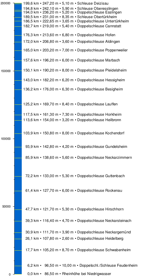
The maximum size of the inland vessels sailing on the Neckar is limited by the dimensions of the lock chambers of the 27 barrages, which are usually 110 m long and 12 m wide; the permissible vehicle dimensions are therefore 105 m × 11.45 m. Since 1952 almost all locks have been given a second chamber and have thus become double locks. In order to save water, 23 of them are channeled through the network, i. H. almost 50% of the water from the full chamber is used to fill the empty chamber (so-called twin sluices ). To avoid ship congestion at the mouth of the Neckar, the Feudenheim entrance barrage received a further lock measuring 190 m × 12 m in 1973. The barrages follow each other at an average distance of a good seven kilometers (between 0.9 and 13.7 km, see table) and serve to overcome a height difference of 160.70 m to the Rhine at low water. The fairway depth has been 2.80 m continuously since 2000, so that the port of Stuttgart can be called by large motor ships from the Rhine with a draft of 2.60 m and a load capacity of around 2200 t. The locks are to be renovated and partially expanded over the next few years. The federal government is investing a total of 575 million euros in this project. The Office for Neckar Expansion Heidelberg was founded in 2007 to implement it . In order to make the Neckar navigable for 135 m long ships, one chamber is sufficiently extended at each double lock. In addition, the old chambers are being renovated and individual sections of the route and turning points are being expanded. The locks between Mannheim and Heilbronn are to be extended until 2026. In 2012, the Gundelsheim lock was awarded the title “most water sports-friendly lock”.
Table of the locks on the Neckar with river kilometers and storage locations in meters above sea level ( NN ) and heads in meters.
|
|---|


In contrast to other waterways such as the Moselle or Main, there are no boat locks except in Bad Cannstatt. That is why motor yachts and sailing boats are usually smuggled into the ship locks. The boat tows installed at the other 26 barrages are often in poor condition or even unusable. In some places, canoes can also use the locks with permission from the lock staff, especially for group trips.
The remote control center in Stuttgart-Obertürkheim (FBZ) has been controlling and monitoring the locks from Deizisau to Stuttgart-Hofen on the upper Neckar since 2004.
Level and flood
The water levels of the Neckar are crucial for its navigability for both professional and recreational shipping. According to the Flood Reporting Ordinance (HMO) of the state of Baden-Württemberg, the following flood reporting heights apply to the gauges :
| level | Water level | Drain | Telephone announcement |
|---|---|---|---|
| Rottweil | 230 cm | 77m³ / s | 0741-8730 |
| Horb | 270 cm | 108 m³ / s | 07451-19700 |
| Kirchentellinsfurt | 330 cm | - | 07121-19700 |
| Plochingen | 300 cm | 290 m³ / s | 07153-19429 |
| Lauffen | 500 cm | 600 m³ / s | 07133-19429 |
| Gundelsheim | 340 cm | - | 06269-19429 |
Plochingen gauge
The Plochingen gauge (since 1905) was the only gauge on the Neckar waterway in a free gradient. In 1962 the movable weir Deizisau was built. To keep the congestion fluctuations away, a threshold was built around 100 m below the Plochingen road bridge and the water level was moved there. The great flood in February 1970 destroyed this threshold of rubble stones. Since the cost of building a new concrete sleeper seemed too high, a more economical solution was found. From the water levels and discharge quantities at the Wendlingen (Neckar-km 206.5 - for the Neckar upper reaches) and Reichenbach (Fils-km 2.5 - for the inflowing Fils) water levels and discharge quantities for the old Plochingen gauge are calculated and algorithmically released.
Flood
- 1824: The worst recorded flood in the Neckar area took place in October 1824. Estimates result in an HQ 4000 , i.e. a 4000 year event .
Freezing over
- 1709: From January 18 to January 28 and from January 31 to February 13 and shortly after February 13 to March 23, 1709 the Neckar was frozen over.
Buildings
Mills

The hydropower of the Neckar drove a large number of mills, some of which are still preserved today:
- A powder mill had existed in Rottweil since the 15th century and was incorporated into the Rottweil powder factory in 1863 .
- In Gundelsheim there is the building of the old Neckar mill from 1604. The mill operation was stopped after the Neckar regulation. The last miller was Master Batz around 1935/36. Technology is no longer available there, at times the building was used for catering. A large coat of arms stone and old inscriptions on the building are also worth seeing.
Power plants
At least since the beginning of the 20th century, when power plants replaced the historic mills, electricity has been generated on a large scale from hydropower on the Neckar. There are several nationally known hydropower plants on the Neckar:
- In February 2010, construction of a hydropower plant began in Horb on the tip of the island at the level of Schillerstrasse, which has officially been supplying electricity from hydropower since April 13, 2011. The hydropower plant is expected to produce around 2.3 million kilowatt hours per year. This is enough to supply around 600 four-person households with electricity. Together with the two existing, refurbished systems, it has an average total output of 437 kW. The total investment amounts to around 5.5 million euros.
- The Bad Niedernau hydropower plant is located in the Bad Niedernau district of Rottenburg .
- The two power plants at Beim Preußischen and Tübinger Strasse are located in Rottenburg am Neckar .
.jpg)
- In Kiebingen , the Rottenburg watch factory Junghans has operated its own power plant since 1903 , which still produces electricity today. For the watch factory, the power plant powered by water and steam was oversized, so that the excess electricity was sold. Today the historic machine house is a listed building. Despite its age, the power plant is a state-of-the-art facility with three special features: It has an innovative turbine blade shape that was developed with the help of computer simulations, special Thordon turbine bearings and an air-filled inflatable weir. Since the modernization, a fish passage has restored the continuity of the dam for fish migrations.
- The river power station near Tübingen-Hirschau and the Rappenberghalde hydropower station , built in 1930, are located between Hirschau and Tübingen . It was completely renovated in 1999, and today its two Kaplan turbines, together with the residual water turbine at the upstream weir in Hirschau, together generate around 7 million kilowatt hours of electricity per year. Every second, 22 cubic meters of water flow into the power plant via a 1.7 kilometer long supply channel. The power plant uses the river Neckar gradient of 7.5 meters.

- At the Neckarwerk hydropower plant in Tübingen , the weir was built as part of the Neckar regulation in 1910/1911 as one of the first roller weir constructions in Germany. It is used to generate electricity and control the river. The water flow of the Neckar in the center of Tübingen can be well regulated by the weir. Before the weir was built, the Neckar was full of gravel banks and had a very flat bank zone. You can see this on many photos and drawings before the building. The floods, which repeatedly flooded the then few buildings in the Wöhrd and in some cases endangered the Neckar Bridge, were prevented with this weir and the other weirs of the Neckar (e.g. in Rottenburg). There is a subsequently added fish ladder for fish. The pedestrian bridge over the weir is an important link between the two banks of the Neckar between Lustnau and the central Eberhards or Neckar bridge. From here you have a beautiful view of the Neckar, old town, collegiate church and castle.

- The Oberesslingen power plant is a run-of-river power plant between two Neckar islands at river kilometer 195.6 in Oberesslingen . The power plant was built in 1929 as part of the Neckar dam regulation based on a design by the architect Paul Bonatz . It has an output of 2.1 MW and supplies around 12.3 GWh of energy per year . The mean flow rate is 45 cubic meters per second.
- In Esslingen, around 5.2 million euros were invested in a new run-of-river power plant on the Hechtkopf. With an output of 1.25 MW and an annual electricity production of 7.1 GWh, more than 4000 people can be supplied with electricity. With the construction of this new hydropower plant, the last barrage on the Neckar was also equipped with turbines. It is framed by the weir system in the Neckar on one side and the historic bridge house over the Hammer Canal on the other.

- The AC Transmission Lauffen-Frankfurt was the world's first on August 25, 1891 transfer of electrical energy with hochgespanntem three-phase . On the occasion of the International Electrotechnical Exhibition , the electricity generated in the Mühlgraben hydropower plant in Lauffen am Neckar was increased to 15 kV and transported over 175 kilometers to Frankfurt am Main , where it operated an artificial waterfall on the exhibition grounds. The power plant was relocated upstream when the Neckar was expanded. The original generator is in the Deutsches Museum .
- The Heilbronn hydropower plant is located on the Altneckar in the city center and not on the canal's traffic route, so there is no lock here.

- At the Karlstor in Heidelberg there is another weir with a lock system; the associated power plant is the only underwater power plant on the Neckar. The building permit granted to Neckar AG in 1994 for the run-of-river power plant at the site contained a number of conditions. Visible changes were not allowed to be made to the existing weir, which was under monument protection, and the new power plant was not supposed to change the historic cityscape of Heidelberg. The technical solution was a power plant sunk invisibly under the river water in the river bed.
- At the weir in Heidelberg , the weir footbridge connects the districts of Wieblingen and Neuenheim. In 2006 urgently needed repair work began, which is to be completed in 2014.
In addition, the Neckar is and was also a source of cooling water for coal and nuclear power plants. Near Esslingen-Zell, the Neckar water cools the Altbach / Deizisau power plant , one of the most modern hard coal power plants in Europe. It comprises two blocks and is located in the districts of the two communities Altbach and Deizisau . Including the gas turbines and the combination block 4, it can feed a maximum of around 1270 MW of electrical power into the grid.
The cogeneration plant Stuttgart-Gaisburg , the incinerator of the power plant Stuttgart-Münster , the power plant Marbach , the Walheim power station , the nuclear power plant Neckarwestheim , the Heilbronn power station and the disused Obrigheim nuclear power plant also obtain their cooling or evaporation of water from the River Neckar.
Crossing structures
Some bridges, some of them very old, lead over the Neckar. The Old Bridge in Heidelberg is one of the most famous historical bridges over the Neckar , which already existed in the high Middle Ages and was built in its present form in 1788. Other historical Neckar bridges are the Neckar Bridge in Lauffen am Neckar, which basically dates back to 1532, the Neckar Bridge in Sulz, built in 1742, the Pliensau Bridge, the Old Agnes Bridge and the Ulrichsbrücke in Köngen. The oldest still preserved Neckar bridge is the Inner Bridge in Esslingen . The 230 meter long structure was built in the 13th century and consists of eleven stone arches.
The Neckar Valley Bridge in Heilbronn is the longest Neckar Bridge at 1348 meters. The prestressed concrete construction from 1967 is ailing and has been replaced by a new building since the beginning of 2018.
In Neckargröningen , the longest free-spanning wooden pedestrian bridge at 85 meters was built in 1990. The unusually constructed structure has a triangular cross-section and is covered with a transparent cover. The oldest prestressed concrete railway bridge in Germany - built in 1957 - is in Heilbronn.
In 1905 there were already 119 bridges over the Neckar, the largest of which was the Neckargartach Neckar Bridge , built between 1903 and 1905, with a total length of 230 meters. In 1985 there were 159 railway, road and path bridges over the Großschifffahrtsstrasse. There were also 126 overhead line crossings and 67 culverts . Today there are around 400 bridges and footbridges on the Neckar, half of them in the upper and half in the middle and lower reaches.
Castles and Palaces
From Mannheim via Heidelberg , Eberbach , Mosbach to Heilbronn, the Burgenstrasse runs almost parallel to the Neckar and leads past numerous castles and palaces on this 100 km long section of the lower Neckar. First of all, of course, the Heidelberg Castle should be mentioned. Among the Neckar castles but also the four castles in Neckarsteinach are mountain Dilsberg , Burg Eberbach , Burg Hirschhorn , Burg Zwingenberg , castle Stolzeneck that Minne Burg , Burg Dauchstein , Schloss Neuburg (Baden) , the Burg Hornberg (the castle of Götz von Berlichingen ) and the Burg Guttenberg ( German Greifenwarte ) Castle Horneck , Ehrenberg .
In the further course upriver to Stuttgart and further on the upper Neckar are the Horkheim Castle and the Neippergsche Schloss Klingenberg , Schloss Lichtenegg , the Esslinger Burg , Burg Remseck, Schloss Liebenstein , the Weiler Burg, the ruin Herrenzimmern , the Castle Hohentübingen , the Castle Weitenburg , the ruins of Albeck near Sulz am Neckar and the ruins of Wehrstein and Neckarburg .

Towers
The Neckar in literature
"Germany is the pinnacle of beauty in summer, but nobody has understood, really perceived and enjoyed the highest degree of this gentle and peaceful beauty who has not rafted down the Neckar."
- The Neckar poem by Friedrich Hölderlin
literature
- Dr. Hanns Heiman: Contributions to the history of the Neckar shipping trade and the Neckar shipping . Die Neckarschiffer Volume 1, C. Winter's Universitätsbuchhandlung , Heidelberg 1907, ( digitized version )
- Dr. Hanns Heiman: The situation of Neckar skippers since the introduction of tug shipping . Die Neckarschiffer Volume 2, C. Winter's Universitätsbuchhandlung , Heidelberg 1907, ( digitized version )
- Jan Bürger : The Neckar. A literary journey . CH Beck, Munich 2013, ISBN 978-3-406-64692-8 .
- The Neckar. The land and its river, ed. from the State Institute for the Environment, Measurements and Nature Conservation Baden-Württemberg . Regional culture publishing house , Ubstadt-Weiher 2007, ISBN 978-3-89735-286-5 .
- Franz X. Bogner : The land of the Neckar. Thorbecke, Stuttgart 2004, ISBN 3-7995-0152-5 .
- Walter Hailer (Ed.): The Neckar - our living space . Ministry for Environment and Transport, Stuttgart; IKoNE office, Besigheim 2003.
- Jörg Bischoff, Norbert Kustos: The Neckar from the source to the mouth . Ellert & Richter , Hamburg 2001, ISBN 3-89234-989-4 (illustrated book).
- Hartmut Müller: The Neckar . (= Literary trips). Ernst Klett Verlag , Stuttgart 1994, ISBN 3-12-895250-7 .
- Helmut Betz: History from the current tape. V - The Neckar shipping from the tow barge to the large motor ship , Krüpfganz, Duisburg 1989, ISBN 3-924999-04-X
- Wolf-Ingo Seidelmann: The Neckar-Danube Canal. 200 years of planning for a waterway across the Alb (= contributions to southwest German economic and social history . Volume 6 ). Scripta-Mercaturae-Verlag, St. Katharinen 1988, ISBN 3-922661-41-6 .
- Andrea Wehr (Ed.): Neckar Reading Book. Stories and poems along the Neckar . Silberburg, Tübingen and Stuttgart 1994, ISBN 3-87407-198-7 .
- Willi Zimmermann : The Neckar. The river of fate in the city [Heilbronn] . Heilbronner Voice , Heilbronn 1985, ISBN 3-921923-02-6 .
- Willi Zimmermann: Heilbronn and its Neckar in the course of history . In: Heilbronn Historical Association . 21st publication , Heilbronn 1954.
- Southwest German Canal Association for the Rhine, Danube and Neckar: Neckarkanal 1935 , Julius Hoffmann publishing house approx. 1935, paperback approx. 21 cm × 21 cm, 109 pages.
- Martin Eckoldt: On the hydrology of the canalized Neckar , communication no. 62, Koblenz, 1955, published by the Federal Institute for Hydrology , Koblenz.
- Behrendt: Hydrology on the Neckar , from the magazine for inland shipping and waterways No. 9, 1973.
- M. Eckoldt (ed.): Rivers and canals. The history of the German waterways. DSV-Verlag 1998
- Wasser- und Schifffahrtsdirektion Südwest : Compendium of the Wasser- und Schifffahrtsdirektion Südwest. Organizational and technical data, inland navigation, tasks, waterways. Self-published, Mainz June 2007
cards
- Land surveying office Baden-Württemberg : Leisure map F513 Mannheim Heidelberg - Neckartal-Odenwald Nature Park (Westblatt). Stuttgart 2006, ISBN 3-89021-606-4 .
- Land surveying office Baden-Württemberg: Leisure card F514 Mosbach - Neckartal-Odenwald Nature Park (Ostblatt). Stuttgart 2006, ISBN 3-89021-607-2 .
- Erhard Jübermann: Water sports hiking maps, sheet 3, Germany southwest . Geocenter, 2004, ISBN 3-929540-13-4 .
- Gerhard Römer (Ed.), Irene-Annette Bergs (Ed.): The Neckar in old maps . Exhibition catalog. Badische Landesbibliothek , Karlsruhe 1988, ISBN 3-88705-022-3 .
Web links
- Waterways & Shipping Office Heidelberg
- Wasserstraßen- & Schifffahrtsamt Stuttgart, historical
- Office for Neckar Development Heidelberg
- Neckar locks
- The Untertürkheim Neckar Bridges
- Flood forecast center Baden-Württemberg with water levels
- The barrages on Classic Modern Baden-Württemberg
- Regional Council Stuttgart: Neckar area
- The water quality of the Neckar 1974 and 2004 (PDF; 1.1 MB)
- Bridges over the Neckar with pictures 1 , 2 , 3 , 4 , 5
- From wild river to waterway - fish fauna and fishing in the Middle Neckar (PDF; 5.0 MB), August 2012, Ralf Haberbosch, Rainald Hoffmann and Hubert Wnuck
- From wild river to waterway - fish fauna and fishing in the Lower Neckar (PDF; 1.9 MB), 2008, Frank Hartmann and Stephan Hüsgen
- Preliminary report on the inventory, Part B, Neckar area
Individual evidence
- ↑ a b According to the contour line image on the geodata viewer.
- ↑ According to LUBW-FG10 (data record entry).
- ↑ According to LUBW-FG10 (data record entries).
- ↑ According to LUBW-BRSWEB, water, catchment areas, aggregated areas 03 (data record entry).
- ^ German Hydrological Yearbook Rhine Region, Part I 2009 State Institute for Environment, Measurements and Nature Conservation Baden-Württemberg, p. 107, accessed on January 22, 2016 (PDF, German, 1.85 MB).
- ↑ Lengths (in km) of the main shipping routes (main routes and certain secondary routes) of the federal inland waterways ( memento of January 21, 2016 in the Internet Archive ), Federal Waterways and Shipping Administration
- ↑ Albrecht Greule . Research on place names in southwest Germany. The river names of Württemberg: results and problems of their research. P. 61 (PDF; 430 kB)
- ↑ Albrecht Greule . Pre- and early Germanic river names on the Upper Rhine, Heidelberg 1973, pp. 141–143, ISBN 3-533-02294-3
- ↑ Werner Besch, Anne Betten, Oskar Reichmann, Stefan Sonderegger (eds.): Language history. A handbook on the history of the German language and its research, Volume 4., 2nd edition, Berlin / New York 2004. P. 3463.
- ↑ Supplementary information on the name on TÜpedia.
- ↑ Section 2: Geology and Soil Science. (PDF) State Office for Geology, Raw Materials and Mining, archived from the original on July 30, 2004 ; accessed on March 20, 2017 (Figure 22).
- ↑ MARCHIVUM : Chronicle star . Neckar, 1275. Retrieved September 27, 2018 .
- ↑ M. Eisenlohr: The river correction near Mannheim and its effect on the development of the city. (PDF 15 MB) Reprint from the 1921 yearbook of the Hafenbautechnischen Gesellschaft (Hamburg). P. 15 and panel 7 , accessed on May 4, 2015 .
- ↑ Quality of the flowing waters in the Neckar catchment area (= IKoNE . No. 5 ). S. 18 ( http://www.ikone-online.de/fileadmin/template/hefte/IKONE_Heft_5.pdf ( Memento from November 23, 2009 in the Internet Archive ) [accessed on March 20, 2017]). Quality of the rivers in the Neckar catchment area ( memento from November 23, 2009 in the Internet Archive )
- ↑ The Jockele of the Ammerdaal Hexa Tübingen eV fool's guild
- ↑ Ursula Wegner: The Black Forest raftsmen (PDF; 113 kB) SWR2 Knowledge - Manuscript Service.
- ↑ M. Eisenlohr: The river correction near Mannheim and its effect on the development of the city. (PDF 15 MB) Reprint from the 1921 yearbook of the Hafenbautechnischen Gesellschaft (Hamburg). Pp. 8–10 , accessed on August 22, 2015 .
- ↑ Helmut Betz: Historisches vom Strom - The Neckarschiffahrt from the tow barge to the large motor ship . 1st edition. tape V . Krüpfganz, Duisburg 1989, ISBN 3-924999-04-X , p. 27, 75 .
- ^ Herbert Komarek: Neckarsteinach 850 years of shipping in the course of time . Ed .: Schifferverein Neckarsteinach e. V. 1st edition. Wartberg Verlag , Gudensberg-Gleichen 2003, ISBN 3-8313-1321-0 , p. 34, 41, 60 .
- ↑ Heide Ringhand: The inland shipping. Flowing streets - living rivers . BeRing Verlag, Velbert-Neviges 1992, ISBN 3-925636-16-1 , p. 86 .
- ↑ Helmut Betz: Historisches vom Strom - The Neckarschiffahrt from the tow barge to the large motor ship . 1st edition. tape V . Krüpfganz, Duisburg 1989, ISBN 3-924999-04-X , p. 75 .
- ^ Herbert Komarek: Neckarsteinach 850 years of shipping in the course of time . Ed .: Schifferverein Neckarsteinach e. V. 1st edition. Wartberg Verlag, Gudensberg-Gleichen 2003, ISBN 3-8313-1321-0 , p. 73 .
- ↑ a b Helmut Betz: Historisches vom Strom - The Neckarschiffahrt from the tow barge to the large motor ship . 1st edition. tape V . Krüpfganz, Duisburg 1989, ISBN 3-924999-04-X , p. 142 .
- ^ Herbert Komarek: Neckarsteinach 850 years of shipping in the course of time . Ed .: Schifferverein Neckarsteinach e. V. 1st edition. Wartberg Verlag, Gudensberg-Gleichen 2003, ISBN 3-8313-1321-0 , p. 54 .
- ↑ Directory E, Ser. No. 37 of the Chronicle ( memento of July 22, 2016 in the Internet Archive ), Federal Waterways and Shipping Administration
- ↑ Heidelberg Waterways and Shipping Office, February 4, 2013 (PDF; 80 kB)
- ↑ Heilbronner port official harbor view ( Memento of 28 September 2007 at the Internet Archive )
- ^ Port of Mannheim Waterside cargo handling
- ^ Port of Mannheim press release
- ↑ Planning of the lock expansion, Office for Neckar Expansion Heidelberg (PDF; 18 kByte)
- ^ Neckar AG and Waterways and Shipping Directorate Southwest: Großschifffahrtsstraße Neckar, 50th anniversary 1935–1985 section Mannheim-Heilbronn
- ^ Rottweil gauge
- ↑ Level Horb
- ↑ Kirchentellinsfurt gauge
- ↑ Plochingen gauge
- ↑ Lauffen gauge
- ↑ Gundelsheim gauge
- ↑ Katrin Bürger, Paul Dostel, Jochen Seidel, Florian Imbery, Mariano Barriendos, Helmut Mayer, Rüdiger Glaser : Hydrometeorological reconstruction of the 1824 flood event in the Neckar River basin (southwest Germany) . In: Hydrological Sciences - Journal - des Sciences Hydrologiques , 51 (5), October 2006, Special issue: Historical Hydrology , pp. 864-877 ( article, pdf , researchgate.net). see also Jochen Seidel, Paul Dostal, Florian Imbery: Analysis of Historical River Floods - A Contribution Towards Modern Flood Risk Management. Chapter 12 in: Jan Emblemsvåg (Berab.): Risk Management for the Future - Theory and Cases , April 2012, ISBN 978-953-510-571-8 , pp. 275-294 ( article, pdf , intechopen.com).
- ↑ Karlheinz Götz: "Cold air roller an Dreikönig 1709". In: Our country. Home calendar for Neckar Valley, Odenwald, building land and Kraichgau. 2015. Verlag Rhein-Neckar-Zeitung GmbH , Heidelberg 2014, ISBN 978-3-936866-57-5 , pp. 123-126.
- ↑ Old Neckar Mill Gundelsheim
- ↑ Press release from Stadtwerke Tübingen on April 13, 2011: Hydroelectric power plant in Horb am Neckar started .
- ↑ a b c EnBw: Hydropower locations
- ↑ Project “From Fishes and Freighters”: Rappenhalde hydropower plant . (PDF; 1.3 MB)
- ↑ Tüpedia: Tübingen weir
- ^ Eckart Schörle: Neckar bridges. Sutton Verlag , 2013, ISBN 978-3-95400-128-6 , page 62.
- ↑ New A6 Neckar valley bridge near Neckarsulm: starting signal for a milestone project. In: swr.de. January 15, 2018, accessed June 3, 2018 .
- ↑ Neckar and Remssteg, DE - Remseck. Hess GmbH, accessed on June 4, 2018 .
- ^ Eckart Schörle: Neckar bridges. Sutton Verlag, 2013, ISBN 978-3-95400-128-6 , page 97.