Neckargröningen
|
Neckargröningen
City of Remseck am Neckar
|
||
|---|---|---|
| Coordinates: 48 ° 52 ′ 38 ″ N , 9 ° 16 ′ 18 ″ E | ||
| Residents : | 2530 (Nov. 30, 2019) | |
| Incorporation : | 1st January 1975 | |
| Postal code : | 71686 | |
| Area code : | 07146 | |
|
Location of Neckargröningen in Baden-Württemberg |
||
|
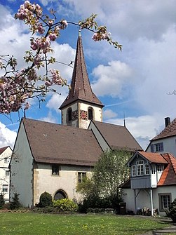
Martinskirche (2012)
|
||
Neckargröningen is a district of Remseck am Neckar in the Ludwigsburg district in Baden-Württemberg .
Location and transport links
Neckargröningen lies directly on the east flowing Neckar . The state road L 1100 / L 1140 runs on the western edge of the city . Neckarrems is on the opposite bank of the Neckar . There the Rems flows into the Neckar. The final stop of the U12 line of the Stuttgart Stadtbahn is in Neckargröningen .
A little north of the town center is the Schiessal industrial park belonging to Neckargröningen .
history
Neckargröningen was first mentioned in a document in 806 as Gruonincheim in a donation to Lorsch Abbey . Affiliation to the Neckargau is also mentioned here. The place received the addition Neckar- in the 13th century to distinguish it from the more important imperial city of Gröningen (today's Markgröningen ). Neckargröningen was also part of Württemberg as early as the 13th century, but was then pledged several times, the first time in 1307 to Georg and Wilhelm von Kaltenthal .
The late Gothic Martinskirche was built around 1450 instead of a Romanesque predecessor and received a new choir in 1515. A Neckar ferry is also mentioned in the 15th century and was in operation until a bridge was built in the 18th century. In 1736 the covered bridge between Neckarrems and Neckargröningen was built. Since 1758 Neckargröningen belonged to the Oberamt Ludwigsburg .
In 1939 the bridge was demolished in the course of straightening the Neckar and replaced by a new building that was destroyed again in 1945 by Wehrmacht troops . In 1951, today's bridge was finally inaugurated.
On January 1, 1975, the place became part of the newly formed community Remseck am Neckar.
coat of arms
Blazon : In blue, two silver fish posed as stakes, turned away. The fish referred to the Neckar fishing, which used to be an important branch of the town. This coat of arms was established in 1938.
Sons and daughters of Neckargröningen
- Ulrich Kienzle (1936–2020), journalist and publicist
See also
Web links
- Neckargröningen on stadt-remseck.de
Individual evidence
- ^ Numbers and data from the city of Remseck
- ↑ a b c Impressions Neckargröningen. In: stadt-remseck.de. Retrieved March 16, 2020 .
- ^ Lutz Reichardt: Place names book of the city district of Stuttgart and the district of Ludwigsburg . In: Publications of the Commission for Regional History in Baden-Wurttemberg - Series B . tape 101 . W. Kohlhammer, Stuttgart 1982, p. 74 .
- ^ Karl Eduard Paulus: Description of the Oberamt Ludwigsburg. Royal Statistical-Topographical Bureau Württemberg, 1859, accessed on March 16, 2020 .
- ^ Thomas Müller, Wolf-Dieter Retzbach: Weather vane, cross and cock . Ed .: Ludwigsburger Kreiszeitung. Ungeheuer + Ulmer, Ludwigsburg 2012, ISBN 978-3-930872-75-6 , p. 134 .
- ^ A b Jürgen Hagel / Heinz Pfizenmayer: The watercourses in the picture of historical maps - ferries and bridge over the Neckar . In: Heinz Pfizenmayer (Hrsg.): Local history series of publications of the municipality of Remseck am Neckar . tape 8 , 1988.


