Hochberg (Remseck)
|
Hochberg
City of Remseck am Neckar
|
||
|---|---|---|
| Coordinates: 48 ° 53 ′ 14 ″ N , 9 ° 16 ′ 48 ″ E | ||
| Residents : | 3536 (Nov. 30, 2019) | |
| Incorporation : | 1st January 1975 | |
| Postal code : | 71686 | |
| Area code : | 07146 | |
|
Location of Hochberg in Baden-Württemberg |
||
|
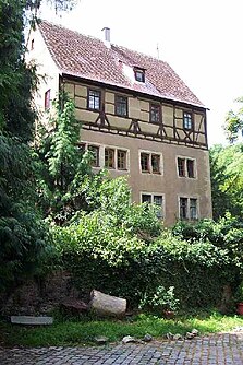
Gatehouse of the castle, built in 1593 by Heinrich Schickhard
|
||
Hochberg is a district of Remseck am Neckar in the Ludwigsburg district in Baden-Württemberg .
Location and transport links
Hochberg lies above the Neckar flowing to the west . The state road L 1100 runs northwest. The highest point of Remseck lies in the Hochberger Wald at 299 m above sea level .
history
Hochberg was first mentioned in a document in 1231. The local nobility is occupied from then until 1291. They built their first castle on a mountain spur above the Neckar.
From around 1300 the knight family Nothaft von Hohenberg, named after Hochberg, took over local rule. With the emergency, Hochberg became part of the knight canton of Kocher . The place was now the centerpiece of a small, imperial direct rule, which among other things also included Hochdorf . Heinrich Schickhardt had the old castle expanded into a representative palace in the 16th century . In the Thirty Years' War Hochberg was severely affected.
In 1684 the last male descendant of the Hohenberg family died and the Hochberg rule passed to the von Gemmingen family . In 1779 Friedrich Eugen von Württemberg bought the Hochberg estate. Two years later he left it to his brother Carl Eugen , who joined the rulership of the ducal Hofkammergut as the Hochberg staff office .
Hochberg, now in Württemberg, became part of the Waiblingen Oberamt in the 19th century . The village church, which had become too small, was torn down in 1852 and replaced two years later by a neo-Gothic church. The grave monuments of the Nothaft family from the old church were integrated into the new church.
Since the 18th century there was also a Jewish community in Hochberg. The Jewish cemetery in Hochberg is a cultural monument. The Hochberg Synagogue, built in 1828, is now used as a church by the Methodist community.
On January 1, 1975, Hochberg became part of the newly formed municipality of Remseck am Neckar.
For more recent history see Remseck am Neckar # Geschichte
coat of arms
Blazon : an open red flight in a silver field. The coat of arms was awarded to the community on November 23, 1953 and is based on the coat of arms of the Nothaft family .
Web links
- Hochberg on stadt-remseck.de
Individual evidence
- ^ Numbers and data from the city of Remseck
- ↑ a b Eduard Theiner: Historical tour through Remseck-Hochberg. (PDF, 1.6 MB) In: stadt-remseck.de. City of Remseck am Neckar, Cultural Office, 2009, accessed on April 2, 2020 .
- ↑ a b Dr. Norbert Stein, Eduard Theiner, Heinz Pfitzenmayer: The Lords of Kaltental and the imperial free Nothaft von Hohenberg . In: Heinz Pfitzenmayer (Hrsg.): Local history series of publications by the community of Remseck am Neckar . tape 9 . Self-published, Remseck am Neckar 1989.
- ^ Thomas Müller, Wolf-Dieter Retzbach: Weather vane, cross and cock . Ed .: Ludwigsburger Kreiszeitung. Ungeheuer + Ulmer, Ludwigsburg 2012, ISBN 978-3-930872-75-6 , p. 131-133 .


