
Gundelsheim (Württemberg)
| coat of arms | Germany map | |
|---|---|---|

|
Coordinates: 49 ° 17 ' N , 9 ° 10' E |
|
| Basic data | ||
| State : | Baden-Württemberg | |
| Administrative region : | Stuttgart | |
| County : | Heilbronn | |
| Height : | 154 m above sea level NHN | |
| Area : | 38.44 km 2 | |
| Residents: | 7254 (Dec. 31, 2018) | |
| Population density : | 189 inhabitants per km 2 | |
| Postal code : | 74831 | |
| Primaries : | 06269, 06265 , 07136 | |
| License plate : | HN | |
| Community key : | 08 1 25 039 | |
| LOCODE : | DE GUN | |
| City structure: | 5 districts | |
City administration address : |
Tiefenbacher Strasse 16 74831 Gundelsheim |
|
| Website : | ||
| Mayoress : | Heike Schokatz | |
| Location of the city of Gundelsheim in the Heilbronn district | ||
  |
||


Gundelsheim is a town in the Heilbronn district in the Franconian north-east of Baden-Württemberg . It belongs to the Heilbronn-Franken region and the edge zone of the European metropolitan region of Stuttgart . Because of its centuries of membership in the Teutonic Order , it is called the Teutonic Order City. Burgenstrasse , a holiday route from Germany to the Czech Republic , runs through the town under the castle .
geography
Geographical location
Gundelsheim is located on the right bank of the Neckar in the north of the Heilbronn district in the transition area between the Neckar basin around Heilbronn and the Odenwald . The Michaelsberg extends northwest of the village and beyond the castle , the plateau of which towers over the Neckar valley by around 100 meters. The deep valley cut of the Neckar tributary Anbach separates it from the settlement area. The longer Lohgraben, which joins the weir and Neckar bridge, flows through the southern local area in a shallow basin .
Neighboring communities
Neighboring cities and communities of Gundelsheim are ( clockwise , starting in the west): Haßmersheim , Neckarzimmern and Billigheim (all three Neckar-Odenwald districts ), Neudenau , Bad Friedrichshall , Offenau and Bad Rappenau (all four districts of Heilbronn).
City structure
The town of Gundelsheim has the districts of Gundelsheim, Bachenau , Höchstberg , Obergriesheim and Tiefenbach .
Gundelsheim itself includes the village of Böttingen , the hamlet Dornbach, the farms Böttinger Hof and Hohschön as well as the residential areas Michaelsberg and Horneck Castle ; at Höchstberg the farm - formerly a hamlet - Bernbrunn and the Bachmühle residential area; to Tiefenbach the residential area Müssigmühle. The town of Nussbaum on the Ilgenberg , which has since been abandoned, was also located in the Höchstberg district .
Division of space

According to data from the State Statistical Office , as of 2014.
history

Until the 18th century
The oldest traces of human settlement from the area around Gundelsheim were found on the Michaelsberg , located immediately to the northwest of the town, and date from the Neolithic Age. The mountain was settled in different places in different epochs of prehistory. a. can also be assigned to the Michelsberg culture , the time of the Celts (around 400 BC) and the Roman era (around 100 AD). The valley locations at the foot of the mountain were settled in early Franconian-Alemannic times (around 300 AD), which is also evident from finds.
Gundelsheim was first mentioned as Gundolfsheim in a document dated to 766 AD in the Lorsch Codex , a list of goods from the Lorsch Monastery , in which other donations from the 8th century in today's Gundelsheim are mentioned. The name indicates a Frankish settlement under a tribal prince Gundolf. The Castle Horneck was probably built during the 12th century. A Ludevicus de Horneck is mentioned in 1238. Around 1250 Konrad von Horneck joined the Teutonic Order and gave it his property in Gundelsheim and Böttingen. A little later, the order came into the possession of the entire town, which was granted town charter by Emperor Charles IV in 1378 , which King Wenceslas confirmed in 1398 and expanded to include market rights . Gundelsheim was then fortified with walls, towers and ditches. The medieval walled city stretched along today's Schloßstraße and its cross streets from the town church to the castle.
In 1438, Horneck Castle, which has since been expanded several times, became the residence of the German Masters of the Teutonic Order. In 1500 the Roman-German King Maximilian I granted his own high court . When the imperial circles were founded in the same year, Gundelsheim came to the Frankish imperial circle as a place in the Deutschordensballei Franken .
In the Peasants' War of 1525, insurgent peasants destroyed Horneck Castle, so that the Deutschmeister moved his seat to Mergentheim and the castle in Gundelsheim, after being rebuilt as a castle until 1533, was only a commandery of the Teutonic Order. From 1546 to 1552 the city suffered various occupations and looting, in 1611 the plague was around and in the Thirty Years' War it initially carried troop marches and billeting, after which there were various occupations, fighting and another plague epidemic up to 1648. Also in the Palatinate War of Succession towards the end of the 17th century, the city was again the victim of pillage, contributions and marching through troops.
In the 18th century the place flourished again under the Teutonic Order. The town church was renovated in 1701, the castle was modernized after 1720, and numerous baroque houses in the village still bear witness to the rich construction activity.

19th century
In December 1805, Gundelsheim and its then districts of Tiefenbach and Höchstberg came to the Kingdom of Württemberg through secularization (nationalization of church or religious property as a result of the Napoleonic Wars) and mediatization (affiliation of smaller sovereign rulers to larger territorial lords) . Gundelsheim lost its official seat and until 1817 was only a sub-office in the Upper Office Neckarsulm . From 1816, the so-called year without a summer , until 1818 there was great hunger due to bad harvests. In the time of Württemberg, city gates, towers and the city wall were quickly torn down, only fragments of which have survived today, and the city grew beyond its medieval borders, while a civic infrastructure was formed: a city doctor had existed since 1829, a pharmacy since 1832 , a poor house since 1845 and the volunteer fire brigade in Gundelsheim since 1863. In 1869 the Böttinger Hof was first mentioned in the Gundelsheim district. In 1878 chain shipping was started on the Neckar , in 1879 the Neckar Valley Railway was built and thus the connection to the route network of the Württemberg State Railways was completed.
20th century
In the course of the Neckar Canalization, the Gundelsheim barrage with lock, bridge and hydroelectric power station was built between 1935 and 1937 . When the so-called Neckar-Enz position was set up , more than 70 bunkers were built in and around Gundelsheim in strictest secrecy.
In 1938, the Württemberg governor Wilhelm Murr ordered Böttingen to be incorporated into Gundelsheim. Also in 1938, through the Württemberg regional reform during the Nazi era , Gundelsheim became part of the Heilbronn district .
In April 1945 US troops occupied the city. There were battles in Tiefenbach and on the Jagst.
Since the place had become part of the American zone of occupation , it belonged to the newly founded state of Württemberg-Baden since 1945 , which in 1952 became part of the current state of Baden-Württemberg.
After the Second World War , the population increased sharply due to the inclusion of displaced persons . Transylvanian Saxons in particular settled here and created the cultural center in their new home at Horneck Castle with the Transylvania home.
Religions

Due to the former membership of the Teutonic Order , Gundelsheim was practically purely Catholic until the early 19th century. Catholics still make up the majority of the population today. In the 19th century, a large number of Protestants settled for the first time, who first held their church services, led by Protestant pastors from the surrounding towns, in the castle chapel and then built the Evangelical Church for themselves in 1895/96 . The Protestant community was elevated to a parish in 1967 with around 1000 members . Today there is also a mosque for Muslim believers, which was completed in 2006 .
The Jewish community of Gundelsheim existed until 1938. Jews had lived in the city since the 16th century. During the Thirty Years War, many Jews from surrounding villages resettled to Gundelsheim, so that in 1644 there were 7 families with 44 people there. A synagogue was probably established as early as the 17th century. In 1705 the Teutonic Order doubled the required protection money in order to persuade needy Jews to leave. The order also tried to oust Jews from the posh streets of the place and to confine them to a remote residential area. In 1725 there were still seven Jewish families with 35 to 40 people, in 1781 only two families. In 1806 there were no more Jews in the area. In the period that followed, only a few Jews lived in Gundelsheim. In 1910 and 1933 there were nine Jewish residents each who, with one exception, emigrated to America by 1938.
Incorporations
- 1938: Böttingen
- April 1, 1962: Bernbrunn (bypassing Allfeld to Höchstberg)
- September 1, 1971: Tiefenbach
- January 1, 1974: Bachenau
- January 1, 1975: Höchstberg , Obergriesheim
Population development
The population figures are census results (¹) or official updates from the Baden-Württemberg State Statistical Office ( main residences only ).
|
|
politics

Municipal council
In Gundelsheim, the municipal council is elected using the spurious sub-district election. The number of local councils can change due to overhang mandates . After the local elections on May 25, 2014, Gundelsheim's municipal council has a total of 25 seats (2009: 23 seats). The municipal council consists of the elected voluntary councilors and the mayor as chairperson. The mayor is entitled to vote in the municipal council. The election resulted in the following distribution of votes and seats:
- CDU 34.3% - 9 seats
- SPD 24.5% - 6 seats
- Citizens active: 21.6% - 5 seats
- Independent list: 16.0% - 4 seats
- Free voters: 3.7% - 1 seat
mayor
Mayor elections were held on April 29, 2007; the incumbent Lothar Oheim did not take up office after 24 years. His successor for the next eight years, Heike Schokatz, was elected with 59.6% of the votes in the first ballot. Uncle was made an honorary citizen of Gundelsheim on the occasion of his departure; his successor took office on June 11, 2007. In 2015 she was re-elected with 50% plus one vote.
badges and flags
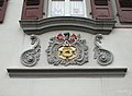
The blazon of the Gundelsheim coat of arms reads: In a quartered shield; Field 1: A continuous black cross in silver; Field 2: Four of red and silver, four (2: 2) blue iron hats in silver; Field 3: In red a golden cross set with kettle ribs (shield fittings); Field 4: In gold, a blue, wavy, oblique left bar, underneath the black capital letter G. The city colors are green and white.
The coat of arms was awarded to the city on March 13, 1538 by the German master Walther von Cronberg . The first field with the Teutonic Cross indicates that the city belongs to the Teutonic Order ; the second field with the iron hats is taken from the family coat of arms of Cronberg. The so-called church clasp of the third field is the coat of arms of the Lords of Horneck, who had given Gundelsheim to the Teutonic Order. The wavy bar in the fourth field indicates the location on the Neckar and the letter G indicates the city name.
The city also had the coat of arms in its seals , the oldest of which can be traced back to an imprint from 1627. The origins of the coat of arms were temporarily forgotten, and from 1904 there is evidence of another coat of arms with a vine on a three mountain , which was also used in the seals from 1936 and from which the flag colors are derived. In 1937 the Württemberg archives suggested that the Teutonic Cross from the old coat of arms should be added to the Rebstock coat of arms, which failed due to the resistance of the Reich Governor Murr . Instead of the Rebstock coat of arms, the city took up its old coat of arms, which was confirmed by the Baden-Württemberg Ministry of the Interior on August 14, 1957.
Culture and sights
Buildings


- Horneck Castle was built in 1533 by the Teutonic Order on the ruins of the old Horneck Castle, which was destroyed in the Peasants' War in 1525. The 35 meter high keep , which haslargely been preserved,became the tower of the new Renaissance, heptagonal palace complex. In 1724 the building was redesigned in Baroque style and the Renaissance bay windows and towers were demolished. From 1897 the castle was used successively as a sanatorium, military hospital and lung sanatorium. Since 1960 the castle has housed the home town of Transylvania , a retirement and nursing home , the Transylvanian Museum and the Transylvania Institute, the cultural center of the Transylvanian Saxons. Worth seeing are u. a. two plaster casts of epitaphs of some Teutonic Knights of the 15th / 16th centuries Century in the gate construction of the castle building.
- In addition to the actual castle buildings, the historical complex also includes several late medieval defense towers , the earlier commandery building from the 16th century and the magnificent gate to Schloßstraße with busts of three Teutonic masters. Two reliefs of unknown origin are built into the medieval wall at the grand gate, which presumably date from Roman times and show the god Hermes and a Roman officer. A war memorial for the fallen soldiers of both world wars has recently been erected in front of her .

Epitaph for Johann Adelmann von Adelmannsfelden in the gatehouse of the castle
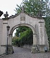
Horneck Castle, grand gate with busts

War memorial 1914-18


- The Catholic parish church of St. Nikolaus is the former hospital church of the Teutonic Order, which in turn goes back to a medieval Anna chapel. The building with the choir, which faces east, was extended to the south in the 15th century to include an early Mass chapel with a Gothic reticulated vault and a tower, and in 1701 it was converted to Baroque style. The nave was extended to the west and north in 1922/23, so that the original west tower, renewed in 1976, now stands in the middle of the church. There are several historical altars and epitaphs in the church.
- The pharmacy north of the town church was built around 1550 and 1595 by the Teutonic Order as a substitute for the originally subsequent west directly to the hospital church hospital acquired. It was destroyed in the Peasants' War in 1525, then rebuilt, and now it turned out to be too small. The building has a striking Renaissance bay window , the baroque statue next to it shows St. Elisabeth of Thuringia with a beggar and dates from 1777. Since 1832 there has been a pharmacy in the building .
- The Georgskapelle in the cemetery is the original town church of Gundelsheim. It has been documented since 1295 and has a conspicuously elevated choir with a roof turret opposite the nave. The lower nave is the older part of the building; the elevated choir was added in 1473. From 1449 until the Reformation, the Heilig-Grab-Kloster Speyer owned the church set for it and was responsible for the maintenance. After it was badly damaged by a low-flying attack on March 19, 1945, the parish priest Rezbach began the restoration work in June 1945, which was completed in June 1946. Two memorial stones on the chapel are used as war memorials to commemorate the fallen of the two world wars.
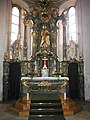
Main altar of the parish church

Epitaph for Fuchs von Kannenberg at the city church
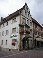
Pharmacy (Old Hospital)


- To the north of the pharmacy is the old school and town hall , which was built in 1541 and was the town hall until 1860, then a school. Diagonally opposite stands the second town hall , which was the administrative seat of the city from 1860 to 1979 before today's modern functional building was erected in Tiefenbacher Straße. In the Schulgasse there is an old schoolhouse , in which classes were held from 1785 to 1910.
- The coat of arms of Commander Johann Christoph von Buseck (1687–1759) can be found on the former Teutonic Order ban in Schloßstraße . In this building, Götz von Berlichingen was appointed field captain of the rebellious peasants during the Peasants' War in 1525.

Old school building 1785–1910
Former ban economy of the Teutonic Order
Coat of arms of the Commander of Buseck


- The old town of Gundelsheim is rich in historical buildings. Many half-timbered houses date back to the 17th and 18th centuries, including the historic Zum Lamm inn from 1692. The building at Wintergasse 3, which is made in the Louis-Seize style with delicate sandstone window parapets and sandstone benches, was recently completed Renovation had an open atrium. This architectural style is very rare in southwest Germany.
- In the Schloßstraße there are not only historical buildings but also two baroque figures of saints on columns. One, a Saint Michael , dates from 1751, on the second column there is a Maria Immaculata from 1772.

Half-timbered building with vaulted cellar from 1607

Baroque door from 1769 with a German cross

St. Michael from 1751

Maria Immaculata from 1772


- Outside the medieval city limits there is a bakery from 1839 and the Evangelical Church , built in the neo-Gothic style in 1895/96 on the corner of Panorama- and Tiefenbacher Strasse .
- At the northern exit of the village in the direction of Tiefenbach, next to the road, there is the Calvarienberg station of the cross , which consists of a chapel from 1627, a crucifixion group and numerous wayside shrines . The chapel originally lined the road to Mosbach, but was moved to its current location in 1858.
- The Gundelsheim barrage on the Neckar is located close to its western settlement boundary, halfway within the city limits

Bakery from 1839
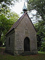
Chapel from 1627 on the Calvary

Crucifixion group on the Calvary


Museums
The Transylvanian Museum in Horneck Castle, the central museum of the Transylvanian Saxons worldwide, shows exhibits on the subject of Transylvania .
Regular events
The Gundelsheim Old Town Festival has been a street festival that has been held almost annually since 1981 and is hosted by local clubs.
Economy and Infrastructure


traffic
Gundelsheim is connected to the national rail network by the Neckar Valley Railway ( Heidelberg - Bad Friedrichshall ). The S41 trams run to Mosbach and Heilbronn every hour. The Federal Highway 27 usually leads on the right bank of the Neckar through the urban area.
The district of Obergriesheim had a train station on the Frankenbahn ( Stuttgart - Würzburg ) until 1971 .
media
The daily newspaper Heilbronner Voice reports on the events in Gundelsheim in its issue N, District North.
education
The Horneck School in Gundelsheim is a primary , secondary and secondary school . There is also the Höchstberg-Untergriesheim elementary school in the Untergriesheim district of Bad Friedrichshall . The Unterland Adult Education Center in Gundelsheim also has a branch. The city library is housed in the Gundelsheim town hall. The Transylvania Institute with library and archive is located at Horneck Castle. There are eight kindergartens, five municipal and three Catholic.
Viticulture
Gundelsheim is a wine-growing place whose vineyards belong to the large Staufenberg site in the Württemberg lowlands of the Württemberg wine-growing region .
The place is known nationwide for the steep slope Himmelreich . The rocky promontory on Michelsberg, clad by meter-high walls, is the steepest still cultivated vineyard in Württemberg and is cultivated partly by the state winery Weinsberg and partly by private vintners.
Established businesses
The largest employer in Gundelsheim is Peter Kwasny GmbH , founded in 1963 , a family company that manufactures paints and spray cans. The Kwasny group of companies employs around 400 people, including around 300 in Gundelsheim and 50 in a logistics center in Sinsheim . The turnover in 2011 was around 60 million euros.
Personalities
sons and daughters of the town
- Kaspar Gretter (approx. 1501–1557), Lutheran theologian and reformer
- Ludwig von Roemheld (1871–1938), internist from Gundelsheim (see Roemheld syndrome ), since 1921 honorary citizen of Gundelsheim
- Paul Wilhelm Wenger (1912–1983), journalist and publicist, advisor to Konrad Adenauer
- Uwe Grund (* 1952), politician ( SPD ) and trade union official
Personalities who worked on site
- Gustav Gündisch (1907–1996), historian and archivist
literature
- Josef Vassillière : Gundelsheim. A guide through the Teutonic Order city. Otto Welker Publishing House, Neckarsulm 1978
Web links
Individual evidence
- ↑ State Statistical Office Baden-Württemberg - Population by nationality and gender on December 31, 2018 (CSV file) ( help on this ).
-
↑ Source for the urban structure section:
Das Land Baden-Württemberg. Official description by district and municipality. Volume IV: Stuttgart district, Franconian and East Württemberg regional associations. Kohlhammer, Stuttgart 1980, ISBN 3-17-005708-1 . Pp. 88-91 - ↑ State Statistical Office, area since 1988 according to actual use for Gundelsheim.
- ↑ https://www.leo-bw.de/web/guest/detail-gis/-/Detail/details/ORT/labw_ortslexikon/1972/Böttinger+Hof+-+Wohnplatz
- ^ Chronicle of Gundelsheim on Gundelsheim.de.
- ^ Federal Statistical Office (ed.): Historical municipality directory for the Federal Republic of Germany. Name, border and key number changes in municipalities, counties and administrative districts from May 27, 1970 to December 31, 1982 . W. Kohlhammer, Stuttgart / Mainz 1983, ISBN 3-17-003263-1 , p. 450 .
- ↑ a b Federal Statistical Office (ed.): Historical municipality register for the Federal Republic of Germany. Name, border and key number changes in municipalities, counties and administrative districts from May 27, 1970 to December 31, 1982 . W. Kohlhammer, Stuttgart / Mainz 1983, ISBN 3-17-003263-1 , p. 465 .
- ↑ Stat. State Office: Population development since 1871 ( page no longer available , search in web archives ) Info: The link was automatically marked as defective. Please check the link according to the instructions and then remove this notice.
- ↑ Gundelsheim: Heike Schokatz is and remains mayor. RNZ, April 28, 2015, accessed December 6, 2018 .
-
^ Sources for the section coat of arms and flag:
Heinz Bardua: The district and community coat of arms in the Stuttgart administrative region . Theiss, Stuttgart 1987, ISBN 3-8062-0801-8 (district and municipality coat of arms in Baden-Württemberg, 1). P. 74
Eberhard Gönner: Book of arms of the city and district of Heilbronn with a territorial history of this area . Archive Directorate Stuttgart, Stuttgart 1965 (Publications of the State Archive Administration Baden-Württemberg, 9). P. 91f. - ^ Franz Xaver Remling : Documented history of the former abbeys and monasteries in what is now Rhine Bavaria , Volume 2, p. 171, Neustadt, 1836; (Digital scan)
- ↑ Diocesan Archives , G. 1.3 Gundelsheim, Fasz. 2
- ↑ VHS Unterland branch offices .
- ↑ Heiko Fritze: The father of the spray paint can . In: Heilbronn voice . 29th August 2012.
- ↑ Konrad Gündisch: History of Horneck Castle, seventh episode: Friedrich Trump and Dr. Ludwig Roemheld . Transylvanian Newspaper , December 29, 2017

Abstatt | Bad Friedrichshall | Bad Rappenau | Bad Wimpfen | Beilstein | Brackenheim | Cleebronn | Eberstadt | Ellhofen | Eppingen | Erlenbach | Flein | Gemmingen | Güglingen | Gundelsheim | Hardthausen am Kocher | Ilsfeld | Ittlingen | Jagsthausen | Kirchardt | Langenbrettach | Lauffen am Neckar | Lehrensteinsfeld | Leingarten | Lion's Arch | Massenbachhausen | Möckmühl | Neckarsulm | Neckarwestheim | Neudenau | Neuenstadt am Kocher | Nordheim | Obersulm | Oedheim | Offenau | Pfaffenhofen | Roigheim | Schwaigern | Siegelbach | Talheim | Untereisesheim | Untergruppenbach | Weinsberg | Rams | Desert red | Zaberfeld