
Kirchardt
| coat of arms | Germany map | |
|---|---|---|

|
Coordinates: 49 ° 12 ' N , 8 ° 59' E |
|
| Basic data | ||
| State : | Baden-Württemberg | |
| Administrative region : | Stuttgart | |
| County : | Heilbronn | |
| Height : | 227 m above sea level NHN | |
| Area : | 21.5 km 2 | |
| Residents: | 5921 (December 31, 2018) | |
| Population density : | 275 inhabitants per km 2 | |
| Postal code : | 74912 | |
| Area code : | 07266 | |
| License plate : | HN | |
| Community key : | 08 1 25 049 | |
| LOCODE : | DE KRD | |
| Community structure: | 3 districts | |
| Address of the municipal administration: |
Goethestrasse 5 74912 Kirchardt |
|
| Website : | ||
| Mayor : | Gerd Kreiter | |
| Location of the municipality of Kirchardt in the Heilbronn district | ||
  |
||


Kirchardt is a municipality in the district of Heilbronn in Baden-Württemberg ( Germany ). It belongs to the Heilbronn-Franken region and the edge zone of the European metropolitan region of Stuttgart .
geography
Geographical location
Kirchardt is located in the northwest of the Heilbronn district and belongs to the fringes of the Stuttgart metropolitan area .
Neighboring communities
Neighboring towns and communities Kirchardts are ( clockwise , starting in the north): Bad Rappenau , Massenbachhausen , Gemmingen , Eppingen , Ittlingen (all districts of Heilbronn) and Sinsheim ( Rhein-Neckar district ). Kirchardt has entered into an agreed administrative partnership with Bad Rappenau and Siegelsbach .
Community structure
In addition to the core community of Kirchardt, Kirchardt also includes the districts of Berwangen and Bockschaft . A lost, so no longer existing place called Lauterstein was partially in the district of Kirchardt.
The municipality of Kirchardt has around 5500 inhabitants (as of 2002), of which 3700 live in the Kirchardt district, 1400 in the Berwangen district and 400 in the Bockschaft district.
Division of space

According to data from the State Statistical Office , as of 2014.
history
Early settlement by Celts, Romans and Alemanni
The first human traces in Kirchardt date back to the Bronze Age , the first settlement in what is today Kirchardt is from the time of the Celts in the 6th century BC. Proven in the Gewann Kreuzend . The Romans built during their occupation 90-260 n. Chr. In various places in "civitas alisinensis" (Elsenzgau) roads and buildings to supply the Neckar-Odenwald-Limes , including in today's municipal area, a villa rustica , which in 1832 Haftenwald was found, as well as a homestead with deep wells on the Schneckenberg . An important Roman road ran through today's Berwangen district, where a so-called Jupiter giant column was also found. With the withdrawal of the Romans from the areas on the right bank of the Rhine around the year 260 and the simultaneous advance of the Alemanni, however, the Roman buildings fell into disrepair.
First mention in the Lorsch Codex and the meaning of the place name
Kirchardt and its districts, like many other towns and communities in the north of what is now Baden-Württemberg, are first mentioned by name in the Lorsch Codex . In the year 791, a nun Egilrat transferred a courtyard and the associated open space in villa Kyrih-Hart to the Lorsch monastery . The place name is an original field name and possibly means “church in the forest” or “forest owned by a church”, but more likely denotes a “forest in which freestyle harriers live”. The Lorsch Codex also mentions today's Berwangen district for the first time in connection with a donation in 793 and today's Bockschaft district when it was donated in 829. The naming as a villa indicates that Kirchardt was only at the beginning of its settlement. Since the settlement center of Kirchardt is located directly on the northern border of the former Berwang district and near the source of the Birkenbach , which flows south to Berwangen and from there on to Richen , it is assumed that Kirchardt was settled from the presumably older and once more important Berwangen, or that both places were successively founded by Richen.
In the early Middle Ages there was a road connection from Heilbronn to Heidelberg , known as the "Hohe Straße" , which ran from Heilbronn to Sinsheim almost analogously to today's B 39 . Kirchardt is a bit off this historical route on the edge of the Kraichgau hill landscape and is surrounded by fields, meadows and mixed oak forests. For centuries the population consisted exclusively of farmers who worked fields and fattened pigs. Acorns have always been important feedstuffs for pig breeding , which is why such a fruit has adorned Kirchardt's coat of arms since 1769. The place name in the 13th to 16th centuries was Kirchart (in different spellings), in the 17th and 18th centuries, however, Kirhart , and only solidified again on Kirchardt in the 19th century .
Palatinate village from the 14th century

In Kirchardter's name , references to a castle have been preserved. There was a castle courtyard as an inheritance courtyard , which was owned by the Dominican monastery in Wimpfen for a long time , and there is a gain in the castle gardens . Since there are no archaeological finds of a castle in the area, these names most likely point to the lost Lauterstein Castle near Massenbachhausen. In the 14th century, the place came to the Count Palatine near Rhine . Thus Kirchardt was Palatine and remained so - initially under the Steinsberg office , from 1521 under the Hilsbach winery in the Upper Office Mosbach - until the end of the Electoral Palatinate in 1803. The church rights, however, lay since the late 14th century with the Teutonic Order , which the Received fruit and wine tithe, but its influence waned after the Reformation of the Palatinate in 1556.
In the Palatinate era , the place was run by a mayor who was appointed by the rulers and the official cellar in Hilsbach and had a certain amount of self-administration. In addition, there was a local court with twelve, and after the Thirty Years War also with only eight or nine members. The first town hall in Kirchardt was built around 1570.
In the Middle Ages, the area around the town was surrounded by a fence ( Etter ) and divided into property owned by free or semi-free farmers and manor land given to farmers as inheritance . The inheritance was not allowed to be divided or reduced, but was subject to the developmental necessities of frequent changes in the population through exchange and, due to their being awarded as a lair, to the appearance of a large number of shareholders. The farmers own goods, however, led by inheritance in fragmented parcelling with equally complicated ownership. In addition, the originally loose form of settlement within the Etter condensed with an increase in the population and the courtyards to form a narrow street village along today's main street with an eastern bulge around the church. The church, first mentioned in 1496, but probably much older, divided the village into Oberdorf (from the church north to the fall gate to Grombach), Mitteldorf (area east of the church) and Unterdorf (from the church south to the fall gate to Berwangen). Originally there were mainly thatched wooden houses in the village. According to the Palatinate State Order of 1531, houses, stables and barns were to be underpinned with a stone foundation, according to an electoral order of 1700 thatched roofs were to be replaced by tile roofs.
After the Thirty Years War, from whose devastation and the subsequent plague the entire surrounding area suffered, Kirchardt still had around 80 inhabitants. The population rose to around 280 by 1686, 420 by 1746, and 509 by 1774.
In 1701 the ruinous condition of the church and rectory gave rise to an expert opinion on whether the Teutonic Order, as a tithe recipient, was also responsible for the maintenance of the simple church. However, the order was only made responsible for the stone part of the church tower and the rectory.
In the second half of the 18th century, under Elector Carl Theodor, the Kirchardt Chaussee was built , a new road from Steinsfurt to the post office in Fürfeld , which replaced the old road , known as Hohe Straße , further north near Grombach, and which is now the B 39 in this section follows. The intensification of traffic in Kirchardt led to the elimination of the trap gates around 1800 and the gradual abandonment of the boundary of the place by the Etter.
Transition to Baden in the 19th century
After the end of the Electoral Palatinate, Kirchardt came to the newly formed Principality of Leiningen for a short time by decree of November 27, 1802 , and then from 1806, together with Berwangen and Bockschaft, fell to the Grand Duchy of Baden , where the village was subordinate to the lordly prince-leining authority of Hilsbach . Leiningen bailiffs were still in existence until 1813 , then grand ducal bailiffs in Baden and from 1831 mayors. The local council took the place of the local court. Around 1810 the Renaissance town hall had become dilapidated, so that it was torn down by 1813 and replaced by a new building on the same spot (corner of Hauptstrasse / Heilbronner Strasse).
Around the year 1800 Kirchardt had about 750 inhabitants who were almost exclusively active in agriculture, whereas in Berwangen at that time there were already some businesses with about the same number of inhabitants. In 1825 Kirchardt had already reached 1030 inhabitants, but was still largely within the limits of the medieval Etter, so that there were great confinement and social problems (poverty, hunger). Because of this, over 100 residents mostly emigrated to America between 1835 and 1860 .
In 1868 the railway line from Heidelberg to Heilbronn with a train station in neighboring Grombach was built, in 1876 the road to Grombach was expanded to make it suitable for the traffic at the time. In 1880 a new school building was built on Heilbronner Strasse. A first economic boom was brought about by the settlement of a total of seven cigar factories in Kirchardt from 1885, which processed the tobacco growing in the area and which by 1900 had around 200 people on their wages. Until 1914, however, these cigar factories remained the only larger commercial operations in the rural village, in which around 1,300 people now lived. The building stock grew from 1817 (96 buildings) to 210 buildings in 1925. Adolf von Oechelhäuser's 1909 directory of the monuments of art in the Sinsheim district in Kirchardt essentially only lists the local church. The older residential buildings would “despite their neglect, in part, as in Richen, have pretty, artistically meaningless but picturesque details on porches, bay windows, stair roofs, etc. like. "
Inflation and the global economic crisis resulted in continued poverty and also increasing unemployment in Kirchardt and the surrounding villages. Nevertheless, a bourgeois culture began to emerge in Kirchardt as well. A folk gymnastics festival in Elsenz-Turngau was held in 1910, and a sports field was opened in 1920.
In 1933 Kirchardt still had about 1300 inhabitants, Berwangen 750 and Bockschaft 130. After Sinsheim was elevated to the status of a district town in 1936, the Sinsheim district became part of Kirchardt, as did Berwangen and Bockschaft. In 1939 there were 1312 inhabitants, at the end of 1945 there were 1475.
Kirchardt after the Second World War
The admission of more than 500 displaced persons in 1946, who thus made up more than a quarter of the population, led to a further deterioration in living conditions and further job shortages. In the post-war period, manual labor and teams of cattle still dominated everyday farm life, the mechanization of farm work began after the currency reform in 1948 and brought further job shortages. In the 1950s, therefore, there was a strong migration of the original population. At the same time, the community made efforts to provide adequate accommodation and the creation of regional commercial structures. The first industrial parks were designated and some industrial companies settled there. From 1948 the Clemens toy factory was one of the first post-war companies in Kirchardt.
In 1963 the “Schneckenberg” development area was developed, in 1965 the “Kurzer See” area below the Haftenwald was designated as a new industrial area, and in 1966 the two new development areas “Hinter den Dorfgärten” and “Steinäcker” followed. At the same time, the construction of the A 6 autobahn from Heilbronn to Mannheim and the land consolidation associated with it and, after 1968, the administrative reform in Baden-Württemberg provided economic impetus . Many of the previously unpaved roads were paved and provided better transport connections. In 1967 the town hall from 1813 was demolished in order to make the through traffic more convenient, and a new town hall building in the new building area "Behind the village gardens" was moved into. From 1968 a new school building was built and then the old school building from 1880 was demolished. The population in 1970 was around 1950 people.
In the course of the community reform, on July 1, 1971, Bockschaft and on September 1, 1971 Berwangen were incorporated into the Kirchardt community.
On the occasion of the district reform, which came into force on January 1, 1973, the Sinsheim district was dissolved and Kirchardt came to the Heilbronn district and thus to the newly created Franconia region . Kirchardt is one of the few north Baden communities in Württemberg counties. On January 1, 1975, an agreed administrative community was founded with the city of Bad Rappenau and the community of Siegelsbach , within which the individual communities remained independent.
In the 1970s, the center of the village began to be deserted after public facilities and the indigenous population gradually migrated to the new development areas. The community therefore pushed demolition and renovation measures from 1978 onwards, but was classified as a commercial community and initially not included in the "Village Development Measures" program of the state of Baden-Württemberg in 1979/80. It was not until late 1984 that it was accepted into the state's urban development program . The final report of the municipal development company Baden-Württemberg in January 1986 confirmed that 96% of the buildings in the approximately 10-hectare redevelopment area in the center of the town were in need of renovation . Subsequently, a design competition "Redesign of the town center" was advertised, on the basis of which the demolition and renovation measures were carried out, which shape the image of the town center today.
Today, craft, industrial, commercial and service companies are based in the entire municipality of Kirchardt and together offer around 1500 jobs.
Religions
Kirchardt and Berwangen, with their late medieval churches, were reformed as Palatinate and Helmstätt villages as early as the 16th century. Catholics did not settle again until later. In 1701 there were 4 Catholics in Kirchardt, in 1809 the Catholic community numbered 46 people. In 1810 the first Catholic church was built in Kirchardt on Heilbronner Straße, which was demolished around 1960 and replaced by a new building in Waldstraße, which was dedicated to St. Giles, the church patron of the pre-Reformation village church.
In Kirchardt and Berwangen there is now a Protestant parish , in Kirchardt there is also a Catholic parish and an evangelical free church ( Baptists ).
Due to the strong influx of migrants since the 1960s, there are also Muslims and members of the Syrian Orthodox faith among the population. Around 800 Arameans alone now make up around 15 percent of the Kirchardt population and built the Mor Gabriel church, consecrated in 2005 . The Syrian Orthodox Church in Baden-Württemberg has its seat in Kirchardt.
A Jewish community with a synagogue and a Jewish cemetery existed only in today's Berwangen district . In Kirchardt, however, only a few Jews lived from the middle of the 17th century. In 1825 nine Jews were counted in Kirchardt, in 1875 there was only one.
politics
Local council and local council
Kirchardts' local council has 15 seats after the local elections on May 25, 2014 . The choice led to the following result:
Another member of the council and its chairman is the mayor.
There is also a local council with four members in the village of Bockschaft. At his suggestion, the municipal council elects a volunteer mayor . These bodies are to be heard on important matters affecting the locality.
mayor
Gerd Kreiter was elected as the new mayor in the second ballot in March 2016.
badges and flags
The blazon of the Kirchardter coat of arms reads: In silver on a horizontal green branch a rising green acorn. The municipality flag is green and white.
The acorn in the Kirchardter coat of arms probably indicates the second syllable -hardt in the place name, which means something like Weidewald; Pasture forests once served, among other things, to fatten cattle with acorns. The coat of arms can be found for the first time in a municipal seal from 1769 and was colored in 1901 by the General State Archives. The flag was awarded on January 31, 1980 by the Heilbronn District Office.
Culture and sights
Buildings and sights
- The Evangelical Church goes back to the original parish church of the village, which was first mentioned in 1496 as St. Aegidius, last renovated in 1790 and expanded in its present form in 1898/99. A baptismal font from the 15th century and an Overmann organ from 1821 have been preserved in the church. The Catholic Church of St. Giles was built in 1960/61 in place of an older Catholic church. The Syrian Orthodox Church Mor Gabriel was built from 1994 and consecrated in 2005.

Protestant church

Catholic Church

Syrian Orthodox Church


- In the center of the village, some courtyard buildings from the Renaissance period have been preserved, including a house from 1578 on Burggärtenweg. Striking buildings from the construction activities of later times are located directly on the B 39 , which crosses the town : several historical courtyard buildings and inns dating back to the 17th century, the old Catholic schoolhouse designed by Christoph Arnold from 1839 with four eye-catching cross-shaped windows in Heilbronner Strasse , the building at Grombacher Str. 1 with its distinctive half-timbered gable and the house at Hauptstrasse 44 .
- War memorial in honor of those who took part in the war 1870/71
- Concrete picket fences (1930s)
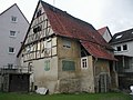
House from 1578
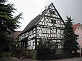
Historic half-timbered house

Shed in the "castle gardens"

War memorial


sport and freetime
Kirchardt owned an outdoor pool from 1925 and has had an indoor pool since 1974. The new sports field in Gewann "Kettend" northeast of the village was built in 1976/77 with the help of American soldiers.
Regular events
Every two years the Kirchardter village festival takes place in the Bockschaft district.
Economy and Infrastructure
traffic
Kirchardt is on the A 6 (Sinsheim-Steinsfurt and Bad Rappenau junctions) and on the B 39 between Heilbronn and Sinsheim. The next train stations are in Bad Rappenau , Sinsheim and Eppingen , stops are in the neighboring towns of Grombach and Gemmingen , where the Kraichgaubahn (Heilbronn – Karlsruhe) runs.
media
The daily newspapers Kraichgau Stimm (a regional edition of Heilbronner Voice ) and Rhein-Neckar-Zeitung report on what is happening in and around Kirchardt .
education
Around 550 students from Kirchardt and its districts attend the Birkenbach School, a primary and secondary school with a technical secondary school . The secondary school is run as an open all-day school . The Kirchardt community library has a stock of around 14,000 media (as of 2005). The Volkshochschule Unterland has a branch in Kirchardt.
economy
Numerous medium-sized companies from a wide variety of industries are based in Kirchardt and its districts. One of the most recent business settlements is the rotogravure printing plant of the APPL group of companies . However, the basic supply of the population in the districts of Berwangen and Bockschaft is falling sharply. There is no shopping option in Bockschaft.
Personalities
Honorary citizen
At the time of National Socialism, as in numerous other communities in Baden, on March 15, 1933, Paul von Hindenburg , Adolf Hitler and the Baden Reichsstatthalter (then still Reich Commissioner ) Robert Wagner were appointed honorary citizens of the Kirchardt community. These were the first honorary citizens of the community. In the Kirchardt municipal council on September 29, 1978, it was established in public that the honorary citizenship of these persons in accordance with the municipal code of Baden-Württemberg expired upon their death (Wagner was the last to die in 1946 by execution). In September 2010 the municipal council repeated this statement.
On April 12, 1984, honorary citizenship was awarded to the former mayor of many years, Heinz Maag (born April 26, 1926, † February 2, 2006), in office from October 30, 1965 to March 31, 1984. With Maag's death in February 2006, his honorary citizenship also expired. On April 8, 2016, the former mayor Rudi Kübler was made an honorary citizen when he left office.
Sons and daughters of the church
- Ludwig Carl Ditzinger (1670–1731), born in Berwangen, Lutheran theologian
- Julius Keller (1847–1911), born in Berwangen, philologist
Web links
Individual evidence
- ↑ State Statistical Office Baden-Württemberg - Population by nationality and gender on December 31, 2018 (CSV file) ( help on this ).
-
^ Source for the section on community structure:
Das Land Baden-Württemberg. Official description by district and municipality. Volume IV: Stuttgart district, Franconian and East Württemberg regional associations. Kohlhammer, Stuttgart 1980, ISBN 3-17-005708-1 . Pp. 57-58 - ↑ Source: Kirchardt in Figures on kirchardt.de, accessed on September 19, 2012
- ↑ State Statistical Office, area since 1988 according to actual use for Kirchardt.
- ↑ The place name Kyrih-Hart is in the original document in the line separation. Without the line separation the name would be Kyrihart .
- ↑ According to Gustav Neuwirth (1978), the place name is analogous to Speßhart (Hart (forest), in which woodpeckers live) for "forest in which freestyle harriers (old name for red kites ) live".
- ↑ Communications from the Württ. And Bad. State Statistical Office No. 2: Results of the population census on December 31, 1945 in North Baden
- ^ Federal Statistical Office (ed.): Historical municipality directory for the Federal Republic of Germany. Name, border and key number changes in municipalities, counties and administrative districts from May 27, 1970 to December 31, 1982 . W. Kohlhammer, Stuttgart / Mainz 1983, ISBN 3-17-003263-1 , p. 479 .
- ↑ https://www.staatsanzeiger.de/staatsanzeiger/wahlen/buergermeisterwahlen/kirchardt/
-
↑ Source for the section coat of arms and flag:
Heinz Bardua: The district and community coat of arms in the Stuttgart administrative region . Theiss, Stuttgart 1987, ISBN 3-8062-0801-8 (district and municipality coat of arms in Baden-Württemberg, 1). P. 84 - ↑ VHS Unterland branch offices .
- ↑ Alexander Hettich: Municipal Council: Hitler not an honorary citizen . In: Heilbronn voice . September 14, 2010 ( from Stimme.de [accessed on September 19, 2010]).

Abstatt | Bad Friedrichshall | Bad Rappenau | Bad Wimpfen | Beilstein | Brackenheim | Cleebronn | Eberstadt | Ellhofen | Eppingen | Erlenbach | Flein | Gemmingen | Güglingen | Gundelsheim | Hardthausen am Kocher | Ilsfeld | Ittlingen | Jagsthausen | Kirchardt | Langenbrettach | Lauffen am Neckar | Lehrensteinsfeld | Leingarten | Lion's Arch | Massenbachhausen | Möckmühl | Neckarsulm | Neckarwestheim | Neudenau | Neuenstadt am Kocher | Nordheim | Obersulm | Oedheim | Offenau | Pfaffenhofen | Roigheim | Schwaigern | Siegelbach | Talheim | Untereisesheim | Untergruppenbach | Weinsberg | Rams | Desert red | Zaberfeld