
District of Sinsheim
| coat of arms | Germany map | |
|---|---|---|

|
Coordinates: 49 ° 10 ' N , 8 ° 55' E |
|
| Basic data (as of 1972) | ||
| Existing period: | 1938-1972 | |
| State : | Baden-Württemberg | |
| Administrative region : | North Baden | |
| Administrative headquarters : | Sinsheim | |
| Area : | 529 km 2 | |
| Residents: | 88,254 (May 27, 1970) | |
| Population density : | 167 inhabitants per km 2 | |
| License plate : | SNH | |
| Circle key : | 08 2 38 | |
| Circle structure: | 52 municipalities | |
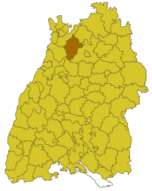
| Location of the district of Sinsheim in Baden-Württemberg | ||
  |
||

The district of Sinsheim was a district in Baden-Württemberg , which was dissolved in the course of the district reform on January 1, 1973 .
geography
location
The district of Sinsheim was in the northwest of Baden-Württemberg .
Geographically, it had a majority share in the northern Kraichgau . The district town was roughly in the middle of the district.
Neighboring areas
Its neighbors were in 1972 clockwise starting in the northwest Heidelberg , Mosbach , Heilbronn , Vaihingen , Karlsruhe and Bruchsal .
history
Before 1803, the area of the district of Sinsheim belonged mainly to the Electoral Palatinate . Then it came to the state of Baden , which was elevated to a Grand Duchy in 1806 . It emerged offices and so in 1813 the district office Sinsheim , which with the neighboring district office Neckarbischofsheim covered the majority of the later district Sinsheim. In 1840 Sinsheim and the neighboring office of Eberbach were raised to Grand Ducal-Badisch-Fürstlich-Leiningische district offices. At the same time, the district office of Hoffenheim was set up for the Princely Liningian places , but it was dissolved again in 1849. In 1864 the Neckarbischofsheim district office was dissolved and its area was assigned to the Sinsheim district office, which belonged to the Mannheim state commissioner district . In 1924, the Eppingen District Office was dissolved and some of the towns became part of the Sinsheim District Office. Like all Baden district offices in 1939 was awarded the district office Sinsheim due to the "Law on the county self-government" the name of the district Sinsheim .
After the formation of the state of Baden-Württemberg in 1952, the district of Sinsheim belonged to the administrative district of North Baden . As a result of the municipal reform from 1970 onwards, the district area changed in three cases. On September 1, 1971, the municipality of Landshausen was assigned to the Bruchsal district because it became part of the newly formed town of Kraichtal on the same day . On January 1, 1972, the communities Eichelberg and Tiefenbach were incorporated into the community Östringen and thus also belonged to the district of Bruchsal.
With effect from January 1, 1973, the district of Sinsheim was finally dissolved. The northern part and with it the district town of Sinsheim was assigned to the newly formed Rhein-Neckar district , the southern part to the Heilbronn district . A few parishes also came to the Karlsruhe district. The legal successor to the district of Sinsheim was the Rhein-Neckar district.
Population development
All population figures are census results.
|
|
The sharp increase in population during and immediately after World War II is due to the influx of refugees and displaced persons. Since the male influx during the war was almost balanced out by relocation losses among the male population, while the female population increased by around 40% in the same period from 1939 to 1945, there was a significant surplus of women in the period that followed.
politics
District Administrator
The senior officials or district administrators of the district office or district of Sinsheim 1813–1972:
- 1813–1823: Georg Bäuerle
- 1823–1834: Moritz Sigel
- 1834–1840: Joseph Lang
- 1841–1844: Makarius Felleisen
- 1845–1847: Wilhelm Bulster
- 1847–1848: Franz Anton Staiger
- 1848–1849: Philipp Bode
- 1849–1852: Ludwig Adolph Wilhelmi
- 1852–1871: Leopold Otto
- 1871–1877: Otto Frey
- 1877–1882: Karl August Kopp
- 1882–1886: Albert Jung
- 1886–1890: Max Becker
- 1890 : Richard Teubner
- 1890–1896: Ludwig Gaddum
- 1896–1902: Franz Keim
- 1902–1904: Adolf von Boeckh
- 1904–1908: Hermann Ludwig Pfeiffer
- 1908–1913: August Maier
- 1914–1924: Alfred Tritscheler
- 1924–1925: Friedreich Thoma
- 1926-1935: Paul Strack
- 1935–1939: Friedrich Denzel
- 1939–1945: Walter Schäfer
- 1945–1946: Roman Großmann (provisional)
- 1946: Gottlob Barth and Kurt von Kirchenheim (both provisional)
- 1946: Wolfgang Rutschke ( charged with running the business )
- 1946–1947: Hermann Lindner (provisional)
- 1947–1948: Johann Gutermann
- 1948: Ludwig Bernheim
- 1948–1949: Georg Steinbrenner (in charge of running the business)
- 1949–1950: Walther Reidel (acting)
- 1950–1972: Paul Herrmann (politician, 1913)
coat of arms
The coat of arms of the district of Sinsheim showed in gold a red armored, black eagle, topped with a breast shield split from gold and black, inside a red sloping bar in front, behind a red crowned, red armored and red tongued golden lion. The coat of arms was awarded to the district of Sinsheim on May 17, 1956 by the Baden-Württemberg Ministry of the Interior.
The coat of arms reflects the historical dominance in the district. The eagle symbolizes the imperial knighthood of Kraichgau , to which some communities in the district belonged until 1803. The majority, however, belonged to the Electoral Palatinate. Therefore, the electoral-Bavarian lion is shown. The sloping beam is taken from the Baden coat of arms. It is also featured in the Eppinger city arms, the second largest city in the district.
Economy and Infrastructure
traffic
In addition to the federal motorway 6 Mannheim-Heilbronn, the federal highways 39 , 45 and 292 run through the district. In terms of rail, the Elsenz Valley Railway and the Steinsfurt – Eppingen railway line should be mentioned.
Communities
From 1938 onwards, 52 municipalities initially belonged to the district of Sinsheim, including 4 towns. In 1945 the American occupation assigned the town of Bad Wimpfen , which until then had belonged to Hesse , to the district of Sinsheim, but in 1952 it came to the district of Heilbronn at the request of the population .
On March 7, 1968, the state parliament of Baden-Württemberg set the course for a community reform . With the law to strengthen the administrative power of smaller municipalities , it was possible for smaller municipalities to voluntarily unite to form larger municipalities. It started with the municipality of Flinsbach in the Sinsheim district, which merged with the municipality of Helmstadt with effect from January 1, 1970. In the period that followed, the number of municipalities steadily decreased until the Sinsheim district was finally dissolved on January 1, 1973.
The largest municipality in the district was the district town of Sinsheim . The smallest community was Bockschaft .
In the table, the municipalities of the Sinsheim district are before the municipal reform. The population figures refer to the census results in 1961 and 1970.
License Plate
On July 1, 1956, the district was assigned the distinctive sign SNH when the vehicle registration number that is still valid today was introduced . It was issued until December 31, 1972.
literature
- District of Sinsheim. (= The city and rural districts of Baden-Württemberg in words and numbers; Issue 13) . Edited by the Ministry of the Interior and Ministry of Economics in Baden-Württemberg, editing and printing of the State Statistical Office of Baden-Württemberg, Stuttgart, 1965. PDF file, 4.8 MB
Individual evidence
- ^ Grand Ducal Baden Government Gazette No. XXII of July 30, 1813, p. 137
- ↑ a b Federal Statistical Office (ed.): Historical municipality register for the Federal Republic of Germany. Name, border and key number changes in municipalities, counties and administrative districts from May 27, 1970 to December 31, 1982 . W. Kohlhammer, Stuttgart / Mainz 1983, ISBN 3-17-003263-1 , p. 478 ff .
.svg)
Basking | Backnang | Baden-Baden | Balingen | Biberach | Boeblingen | Bruchsal | Book | Bühl | Calw | Crailsheim | Donaueschingen | Ehingen | Emmendingen | Esslingen | Freiburg (city) | Freiburg (State) | Freudenstadt | Friedrichshafen | Göppingen | Hechingen | Heidelberg (city) | Heidelberg (Country) | Heidenheim | Heilbronn (city) | Heilbronn (Land) | Black Forest | Horb | Karlsruhe (city) | Karlsruhe (State) | Throat | Constance (city) | Constance (Country) | Künzelsau | Lahr | Leonberg | Loerrach | Ludwigsburg | Mannheim (city) | Mannheim (State) | Mergentheim | Mosbach | Muellheim | Münsingen | Neustadt | Nürtingen | Offenburg | Öhringen | Pforzheim (city) | Pforzheim (Country) | Rastatt | Ravensburg | Reutlingen | Rottweil | Säckingen | Saulgau | Schwäbisch Gmünd | Schwäbisch Hall | Sigmaringen | Sinsheim | Stockach | Stuttgart | Tauberbischofsheim | Tettnang | Tübingen | Tuttlingen | Überlingen | Ulm (city) | Ulm (State) | Vaihingen | Villingen | Villingen-Schwenningen | Waiblingen | Waldshut | Cheeks | Wolfach