
District of Muellheim
| coat of arms | Germany map | |
|---|---|---|
 Help on coat of arms |
Coordinates: 47 ° 50 ' N , 7 ° 40' E |
|
| Basic data (as of 1972) | ||
| Existing period: | 1938-1972 | |
| State : | Baden-Württemberg | |
| Administrative region : | South Baden | |
| Administrative headquarters : | Muellheim | |
| Area : | 433 km 2 | |
| Residents: | 62,258 (May 27, 1970) | |
| Population density : | 144 inhabitants per km 2 | |
| License plate : | Garbage | |
| Circle key : | 08 3 39 | |
| Circle structure: | 49 municipalities | |
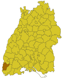
| Location of the district of Müllheim in Baden-Württemberg | ||
  |
||

The district of Müllheim was a district in Baden-Württemberg that was dissolved in the course of the district reform on January 1, 1973 . The administrative seat was the then " large district town " Müllheim .
geography
location
The district of Müllheim was located in the southwest of Baden-Württemberg.
Geographically, the district predominantly had a share in the Upper Rhine Plain . The district seat of Müllheim was roughly in the middle of the district area.
Neighboring areas
Its neighbors in 1972 were the Freiburg district in the north and the Lörrach district in the east and south . In the west, the Rhine formed the natural border with the French department of Haut-Rhin .
history
Before 1800 the area of the later district of Müllheim belonged mainly to the margraviate of Baden ( dominion of Badenweiler ). The area mainly belonged to the Badenweiler Oberamt. In 1809 the office of Müllheim was formed within the Wiesenkreis (later Dreisamkreis), which has changed several times in the course of history. In 1864 it was elevated to a district office within the regional commissioner district of Freiburg . In 1939 the district office of Müllheim was given the name Landkreis Müllheim.
After the formation of the state of Baden-Württemberg in 1952, the district of Müllheim belonged to the administrative district of South Baden . As a result of the municipal reform in 1970, the district area changed in one case. On December 1, 1971, the municipality of Biengen, Freiburg district, was incorporated into the Bad Krozingen municipality and thus became part of the Müllheim district.
With effect from January 1, 1973, the district of Müllheim was dissolved. Its communities in the north went on in the newly formed district of Breisgau-Hochschwarzwald , which thus became the legal successor of the district of Müllheim. Some communities in the south of the district became part of the enlarged district of Lörrach .
Population development
All population figures are census results.
| year | 1939 | 1950 | 1961 | 1970 |
|---|---|---|---|---|
| Residents | 42,622 | 47,068 | 54,471 | 62,258 |
politics
District Administrator
The senior officials or district administrators of the district office or district of Müllheim 1809–1972:
- 1803–1810: Gottlob Heinrich Maier
- 1810–1814: Johann Carl Müller
- 1814–1822: Johann Friedrich Wagner
- 1823–1826: Jakob Wundt
- 1826–1837: Karl Heinrich Leussler
- 1837–1842: Adolf Schrickel
- 1842–1843: Wilhelm Bausch
- 1843-1849: Fidel Kuen
- 1849–1861: Camill Winter
- 1861–1872: Ludwig Sachs
- 1872–1877: Adolf Fuchs
- 1877–1882: Albert Jung
- 1882–1884: Theodor Clauss
- 1884–1888: Julius Lacher
- 1888–1891: Ernst Müller
- 1891–1893: Moritz Seubert
- 1893–1897: Hans von Krafft-Ebing
- 1897–1903: Otmar Schellenberg
- 1903–1907: Wolfgang von Preen
- 1907–1919: Heinrich Hebting
- 1919–1926: Richard Hepp
- 1926–1927: August Pfützner
- 1927–1931: Friedrich Schmitt
- 1931–1933: Heinrich Groß
- 1933–1944: Friedrich Ribstein
- 1945–1947: Adolf Bachmann
- 1947: Fritz Höfer (acting)
- 1947–1972: Berthold Allgaier
coat of arms
The district of Müllheim did not have its own coat of arms: although the district wanted to have one of its own in the 1960s, the creation of a coat of arms was so protracted that none was found before the district reform came into force.
Economy and Infrastructure
traffic
The federal motorway 5 Karlsruhe-Basel ran through the western district area from north to south . Federal highway 3 also ran through the district.
Communities
From 1936, 49 municipalities initially belonged to the district of Müllheim, of which 6 were towns.
On March 7, 1968, the state parliament of Baden-Württemberg set the course for a community reform . With the law to strengthen the administrative power of smaller municipalities , it was possible for smaller municipalities to voluntarily unite to form larger municipalities. The beginning in the district of Müllheim was made on January 1st, 1970 by the municipality of Vögisheim, which merged with the city of Müllheim. In the period that followed, the number of communities steadily decreased until the district of Müllheim was finally dissolved on January 1, 1973.
Most of the inhabitants were in the district town of Müllheim, while the community of Gallenweiler had few.
In the table, the municipalities of the district of Müllheim are before the municipal reform. The population figures refer to the census results in 1961 and 1970.
License Plate

On July 1, 1956, the district was assigned the distinctive MÜL sign when the license plates that are still valid today were introduced . It was issued until December 31, 1972.
Individual evidence
- ↑ a b Federal Statistical Office (ed.): Historical municipality register for the Federal Republic of Germany. Name, border and key number changes in municipalities, counties and administrative districts from May 27, 1970 to December 31, 1982 . W. Kohlhammer, Stuttgart / Mainz 1983, ISBN 3-17-003263-1 , p. 498 f .
.svg)
Basking | Backnang | Baden-Baden | Balingen | Biberach | Boeblingen | Bruchsal | Book | Bühl | Calw | Crailsheim | Donaueschingen | Ehingen | Emmendingen | Esslingen | Freiburg (city) | Freiburg (State) | Freudenstadt | Friedrichshafen | Göppingen | Hechingen | Heidelberg (city) | Heidelberg (Country) | Heidenheim | Heilbronn (city) | Heilbronn (Land) | Black Forest | Horb | Karlsruhe (city) | Karlsruhe (State) | Throat | Constance (city) | Constance (Country) | Künzelsau | Lahr | Leonberg | Loerrach | Ludwigsburg | Mannheim (city) | Mannheim (State) | Mergentheim | Mosbach | Muellheim | Münsingen | Neustadt | Nürtingen | Offenburg | Öhringen | Pforzheim (city) | Pforzheim (Country) | Rastatt | Ravensburg | Reutlingen | Rottweil | Säckingen | Saulgau | Schwäbisch Gmünd | Schwäbisch Hall | Sigmaringen | Sinsheim | Stockach | Stuttgart | Tauberbischofsheim | Tettnang | Tübingen | Tuttlingen | Überlingen | Ulm (city) | Ulm (State) | Vaihingen | Villingen | Villingen-Schwenningen | Waiblingen | Waldshut | Cheeks | Wolfach