
Donaueschingen district
| coat of arms | Germany map | |
|---|---|---|

|
Coordinates: 47 ° 55 ' N , 8 ° 35' E |
|
| Basic data (as of 1972) | ||
| Existing period: | 1938-1972 | |
| State : | Baden-Württemberg | |
| Administrative region : | South Baden | |
| Administrative headquarters : | Donaueschingen | |
| Area : | 770 km 2 | |
| Residents: | 76,165 (May 27, 1970) | |
| Population density : | 99 inhabitants per km 2 | |
| License plate : | DS | |
| Circle key : | 08 3 32 | |
| Circle structure: | 59 municipalities | |
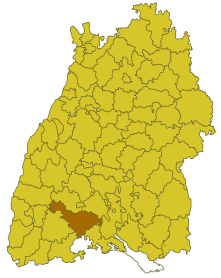
| Location of the Donaueschingen district in Baden-Württemberg | ||
  |
||

The district of Donaueschingen was a district in Baden-Württemberg , which was dissolved on January 1, 1973 as part of the district reform .
geography
location
The district of Donaueschingen was in the southwest of Baden-Württemberg .
Geographically, the Donaueschingen district had a share in the foothills of the Black Forest and the Swabian Alb . The middle district was part of the Baar landscape . The district town of Donaueschingen was roughly in the middle of the district area.
Neighboring areas
Its neighbors were in 1972 clockwise starting in the north of Villingen , Tuttlingen , Stockach , Konstanz , Schaffhausen , Waldshut , Hochschwarzwald and Emmendingen .
history
The area of the later district of Donaueschingen belonged to various domains before 1800, including the Principality of Fürstenberg . In 1806, the area came to Baden , which initially formed several offices , including the offices or district offices of Blumberg, Bräunlingen, Hüfingen, Möhringen and Triberg, which have changed or partially dissolved several times over the course of history. The district office of Donaueschingen , which belonged to the Seekreis, emerged from the office in Hüfingen in 1844 . The Triberg office was part of the Upper Rhine District . From 1864, both of the district offices still existing in the later district area belonged to the state commissioner district of Constance . In 1924 the Triberg District Office was dissolved, and some communities came to the Donaueschingen District Office. In 1936 other communities came to the district office of Donaueschingen, but there were also some communities, and in 1939 this was given the designation of the district of Donaueschingen.
After the formation of the state of Baden-Württemberg in 1952, the district of Donaueschingen belonged to the administrative district of South Baden . As a result of the municipal reform from 1970, the district area changed in several cases. First, on January 1, 1971, the municipality of Nordhalden in the district of Konstanz merged with the city of Blumberg, thus changing the district. On September 1, 1971, the communities of Biesingen, Oberbaldingen and Öfingen, on January 1, 1972, the communities of Hochemmingen and Sunthausen, and on April 1, 1972, the community of Unterbaldingen were combined with the town of Bad Dürrheim in the Villingen district, thereby leaving the Donaueschingen district. On April 1, 1972, the municipality of Tannheim also left the district of Donaueschingen when it was incorporated into the newly formed town of Villingen-Schwenningen on January 1, 1972 .
With effect from January 1, 1973, the Donaueschingen district was dissolved. Its communities were mainly in the newly formed Schwarzwald-Baar district , which thus became the legal successor to the Donaueschingen district. Some communities were incorporated into the enlarged Tuttlingen district. One community each came to the district of Breisgau-Hochschwarzwald and one to the district of Constance. Since then, all districts have belonged to the Freiburg administrative district .
Population development
All population figures are census results.
|
|
politics
District Administrator
The senior officials or district administrators of the district office or district of Donaueschingen 1844–1972:
- 1844–1849: Karl Josef Leo
- 1849–1852: Johann Speer
- 1852–1854: August Wänker
- 1854: Felix Behagel , official administrator
- 1855–1861: Johann Nepomuk
- 1861–1866: Karl Haas
- 1866–1870: Carl Lang
- 1871–1877: Alexander Wallau
- 1877–1881: Richard Bensinger
- 1881–1887: Karl Heil
- 1887: Julius Becker
- 1887–1888: Franz Weber
- 1888-1891: Albert Muth
- 1891–1896: Karl Krems
- 1896–1899: Moritz Seubert
- 1899–1900: Eduard Seldner
- 1901–1904: Otto Flad
- 1904–1913: Lukas Strauss
- 1914–1920: Alexander Schaible (represented by Georg Herrmann from 1914 and by Theodor Leutwein from 1918 )
- 1920–1922: Otto Weitzel
- 1922–1928: Gustav Wöhrle
- 1928–1933: Friedrich Pfaff
- 1933–1934: Johannes Duntze
- 1934–1937: Felix Becker
- 1937–1945: Rudolf Binz
- 1945: Erwin Trippel (administrator)
- 1945: Max Egon Prince zu Fürstenberg
- 1945: Fritz Mauthe
- 1945–1972: Robert Lienhart
coat of arms
The coat of arms of the Donaueschingen district showed three golden ears of wheat next to each other in a shield split by blue and gold, and two black cogwheels on top of each other in the back. The coat of arms was awarded by the Ministry of the Interior of Baden-Württemberg on June 11, 1956.
The heraldic symbols stand for agriculture and industry in the district.
Economy and Infrastructure
traffic
There was no federal motorway running through the district . Therefore, the district was only developed through the federal road 31 and several district roads.
Communities
From 1936, 59 municipalities initially belonged to the district of Donaueschingen, of which 8 were towns.
On March 7, 1968, the state parliament of Baden-Württemberg set the course for a community reform . With the law to strengthen the administrative power of smaller municipalities , it was possible for smaller municipalities to voluntarily unite to form larger municipalities. The beginning in the district of Donaueschingen was made on April 1, 1970 by the municipality of Sumpfohren, which merged with the city of Hüfingen . In the period that followed, the number of communities steadily decreased.
On January 1, 1973, the Donaueschingen district was finally dissolved, it was divided between the Tuttlingen district and the new Schwarzwald-Baar district , with the exception of Stetten and Unadingen, which united with communities in other districts.
The largest municipality in the district was the district town of Donaueschingen. The smallest community was Mistelbrunn.
In the table, the municipalities of the Donaueschingen district are before the municipal reform. The population figures refer to the census results in 1961 and 1970.
Footnote:
1 "Kirchen und Hausen" was renamed "Kirchen-Hausen" in 1961
License Plate
On July 1, 1956, the district was assigned the distinguishing mark DS when the vehicle registration number that is still valid today was introduced . It was issued until December 31, 1972.
Individual evidence
- ↑ a b Federal Statistical Office (ed.): Historical municipality register for the Federal Republic of Germany. Name, border and key number changes in municipalities, counties and administrative districts from May 27, 1970 to December 31, 1982 . W. Kohlhammer, Stuttgart / Mainz 1983, ISBN 3-17-003263-1 , p. 494 f .
.svg)
Basking | Backnang | Baden-Baden | Balingen | Biberach | Boeblingen | Bruchsal | Book | Bühl | Calw | Crailsheim | Donaueschingen | Ehingen | Emmendingen | Esslingen | Freiburg (city) | Freiburg (State) | Freudenstadt | Friedrichshafen | Göppingen | Hechingen | Heidelberg (city) | Heidelberg (Country) | Heidenheim | Heilbronn (city) | Heilbronn (Land) | Black Forest | Horb | Karlsruhe (city) | Karlsruhe (State) | Throat | Constance (city) | Constance (Country) | Künzelsau | Lahr | Leonberg | Loerrach | Ludwigsburg | Mannheim (city) | Mannheim (State) | Mergentheim | Mosbach | Muellheim | Münsingen | Neustadt | Nürtingen | Offenburg | Öhringen | Pforzheim (city) | Pforzheim (Country) | Rastatt | Ravensburg | Reutlingen | Rottweil | Säckingen | Saulgau | Schwäbisch Gmünd | Schwäbisch Hall | Sigmaringen | Sinsheim | Stockach | Stuttgart | Tauberbischofsheim | Tettnang | Tübingen | Tuttlingen | Überlingen | Ulm (city) | Ulm (State) | Vaihingen | Villingen | Villingen-Schwenningen | Waiblingen | Waldshut | Cheeks | Wolfach