
District of Säckingen
| coat of arms | Germany map | |
|---|---|---|

|
Coordinates: 47 ° 40 ' N , 8 ° 0' E |
|
| Basic data (as of 1972) | ||
| Existing period: | 1938-1972 | |
| State : | Baden-Württemberg | |
| Administrative region : | South Baden | |
| Administrative headquarters : | Säckingen | |
| Area : | 371 km 2 | |
| Residents: | 75,344 (May 27, 1970) | |
| Population density : | 203 inhabitants per km 2 | |
| License plate : | SÄK | |
| Circle key : | 08 3 43 | |
| Circle structure: | 53 municipalities | |
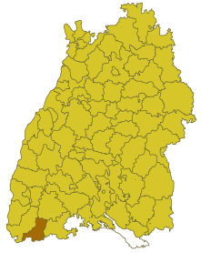
| Location of the district of Säckingen in Baden-Württemberg | ||
  |
||

The district of Säckingen was a district in Baden-Württemberg , which was dissolved in the course of the district reform on January 1, 1973 .
geography
location
The district of Säckingen was in the southwest of Baden-Württemberg .
Geographically, the district of Säckingen had a share in the Black Forest , its southern foothills and the Hotzenwald to the east. The district town of Säckingen (today Bad Säckingen ) was on the southern edge of the district directly on the Rhine.
Neighboring areas
Its neighbors were Lörrach , Hochschwarzwald and Waldshut in 1972, starting clockwise in the west . In the south, the Rhine formed the natural border with Switzerland .
history
Before 1800, the area that would later become the district of Säckingen belonged to a large number of different dominions. In 1806 the area came to Baden , which initially formed several offices , including Beuggen, Nollingen, Säckingen, Wehr and Kleinlaufenburg, but almost all of them were soon dissolved. From 1819 only the office of Säckingen existed, which changed several times in the course of history, initially belonging to the Wiesenkreis and from 1815 to the Upper Rhine District. In 1864 it belonged to the regional commissioner district of Freiburg and in 1936 it was enlarged by some communities from the dissolved Schopfheim office . In 1939 it was named the district of Säckingen.
After the formation of the state of Baden-Württemberg in 1952, the district of Säckingen belonged to the administrative district of South Baden . As a result of the municipal reform in 1970, the district area changed in one case. On January 1, 1971, the municipality of Schlageten was combined with the municipality of Immeneich , district of Waldshut, to form the new municipality of Albtal (which, however, was incorporated into St. Blasien in 1974 ) and thus left the district of Säckingen.
With effect from January 1, 1973, the district of Säckingen was dissolved. Most of its communities went into the enlarged district of Waldshut , which became the legal successor of the district of Säckingen. Five municipalities in the western district area merged into the enlarged Lörrach district .
Population development
All population figures are census results.
|
|
politics
District administrators
The senior officials or district administrators of the district office or district of Säckingen 1814–1972:
- 1814–1819: Franz Xaver Bossi
- 1819–1828: Hermann Th. Burstert
- 1828–1831: Ludwig Friedrich Eichrodt
- 1831–1846: Raphael von Weinzierl
- 1847–1849: Johann Baptist Schey
- 1849–1855: Adolf Leiber
- 1855–1860: Johann Baptist Rieder
- 1860–1864: Otto Sachs
- 1864: Johann Nepomuk Wetzel
- 1865–1872: Franz Müller
- 1872–1877: Gustav Eschborn
- 1877–1879: Ferdinand Lewald
- 1879–1884: Wilhelm Holtzmann
- 1884–1888: Ernst Müller
- 1888–1891: Moritz Seubert
- 1891–1899: Oskar Frech
- 1899–1904: Hermann Ludwig Pfeiffer
- 1904–1918: Albert Kapferer
- 1918–1919: Paul Schwoerer
- 1920–1934: Werner von Rotberg
- 1934–1936: Johannes Duntze
- 1936–1937: Karl Vierling
- 1937–1945: Franz Schühly
- 1945–1949: Alfons Oswald
- 1949–1968: Otto Bischof
- 1968–1972: Otto Leible
coat of arms
The coat of arms of the district of Säckingen showed, in a shield split by red and gold, a floating silver abbot's staff at the front, the curved bend of which is covered with green stones, at the back a red lightning bolt pointing diagonally upwards. The coat of arms was awarded to the district of Säckingen on August 25, 1966 by the Baden-Württemberg Ministry of the Interior . The abbot symbolizes the Säckingen monastery , the lightning bolt stands for energy generation in a circle. The first run-of-river power plant in Europe was built in the area that was then part of the Säckingen district office, but has belonged to the neighboring district of Lörrach since 1973 . The blazon indicates the Baden colors of red and yellow and the colors of Upper Austria (red and white), to which the area previously belonged or came in 1806.
Economy and Infrastructure
traffic
There was no federal motorway running through the district . Therefore, the district was only developed through the federal highway 34 and several district roads.
Communities
From 1936 onwards, initially 53 communities belonged to the district of Säckingen, 5 of them towns.
On March 7, 1968, the state parliament of Baden-Württemberg set the course for a community reform . With the law to strengthen the administrative power of smaller municipalities , it was possible for smaller municipalities to voluntarily unite to form larger municipalities. The beginning in the district of Säckingen was made on January 1st, 1971 by the municipalities of Urberg, Wilfingen, Wittenschwand and Wolpadingen, which merged to form the new municipality of Dachsberg (southern Black Forest). At the same time, the municipality of Schlageten merged with the neighboring municipality of Immeneich, district of Waldshut to form the new municipality of Albtal . In the period that followed, the number of communities steadily decreased until the district of Säckingen was finally dissolved on January 1, 1973.
The largest municipality in the district was the city of Rheinfelden (Baden). The smallest community was Rütte.
In the table, the municipalities of the district of Säckingen are before the municipal reform. The population figures refer to the census results in 1961 and 1970.
License Plate

On July 1, 1956, the district was assigned the distinctive sign SÄK when the vehicle registration number that is still valid today was introduced . It was the only distinguishing mark in which the letter Ä appeared. It was issued until December 31, 1972.
Individual evidence
- ↑ a b Federal Statistical Office (ed.): Historical municipality register for the Federal Republic of Germany. Name, border and key number changes in municipalities, counties and administrative districts from May 27, 1970 to December 31, 1982 . W. Kohlhammer, Stuttgart / Mainz 1983, ISBN 3-17-003263-1 , p. 501 f .
.svg)
Basking | Backnang | Baden-Baden | Balingen | Biberach | Boeblingen | Bruchsal | Book | Bühl | Calw | Crailsheim | Donaueschingen | Ehingen | Emmendingen | Esslingen | Freiburg (city) | Freiburg (State) | Freudenstadt | Friedrichshafen | Göppingen | Hechingen | Heidelberg (city) | Heidelberg (Country) | Heidenheim | Heilbronn (city) | Heilbronn (Land) | Black Forest | Horb | Karlsruhe (city) | Karlsruhe (State) | Throat | Constance (city) | Constance (Country) | Künzelsau | Lahr | Leonberg | Loerrach | Ludwigsburg | Mannheim (city) | Mannheim (State) | Mergentheim | Mosbach | Muellheim | Münsingen | Neustadt | Nürtingen | Offenburg | Öhringen | Pforzheim (city) | Pforzheim (Country) | Rastatt | Ravensburg | Reutlingen | Rottweil | Säckingen | Saulgau | Schwäbisch Gmünd | Schwäbisch Hall | Sigmaringen | Sinsheim | Stockach | Stuttgart | Tauberbischofsheim | Tettnang | Tübingen | Tuttlingen | Überlingen | Ulm (city) | Ulm (State) | Vaihingen | Villingen | Villingen-Schwenningen | Waiblingen | Waldshut | Cheeks | Wolfach