
District of Öhringen
| coat of arms | Germany map | |
|---|---|---|

|
Coordinates: 49 ° 10 ' N , 9 ° 30' E |
|
| Basic data (as of 1972) | ||
| Existing period: | 1938-1972 | |
| State : | Baden-Württemberg | |
| Administrative region : | North Württemberg | |
| Administrative headquarters : | Öhringen | |
| Area : | 398 km 2 | |
| Residents: | 48,781 (May 27, 1970) | |
| Population density : | 123 inhabitants per km 2 | |
| License plate : | EAR | |
| Circle key : | 08 1 44 | |
| Circle structure: | 51 municipalities | |
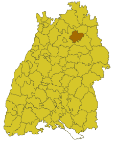
| Location of the district of Öhringen in Baden-Württemberg | ||
  |
||

The district of Öhringen was a district in Baden-Württemberg , which was dissolved in the course of the district reform on January 1, 1973 .
geography
location
The district of Öhringen was in the northeast of Baden-Württemberg .
Geographically, he had a share in the Hohenlohe plain and the Waldenburg mountains . The Kocher , a right tributary of the Neckar , ran through the district .
Neighboring areas
Its neighbors were 1972 clockwise beginning in the north Künzelsau , Schwäbisch Hall and Heilbronn .
history
Before 1800, the area of the district of Öhringen belonged mainly to the Principality of Hohenlohe . Due to the effects of the Reichsdeputationshauptschluss , the area came to Württemberg , where it initially belonged to the Oberamt Neuenstein in the district of Öhringen. In 1810/11 it became part of the newly founded Oberamt Öhringen within the Landvogtei an der Jagst and from 1818 it belonged to the Jagstkreis (which was dissolved in 1924). In 1926 the neighboring Oberamt Weinsberg was dissolved and parts of it were incorporated into the Oberamt Öhringen. In 1934 the Oberamt Öhringen was renamed the Öhringen district and in 1938 it was transferred to the Öhringen district.
The division of Württemberg due to the occupation after the Second World War led to the affiliation to the new state of Württemberg-Baden . With the restructuring of the federal states in southwest Germany, the district came to Baden-Württemberg in 1952 and was added to the administrative district of North Württemberg . As a result of the municipal reform from 1970, the district area changed in four cases. On January 1, 1972, the municipality of Muthof, district of Künzelsau , was incorporated into the city of Forchtenberg and thus became part of the district of Öhringen. Eschental and Goggenbach also came from the Schwäbisch Hall district to the Öhringen district on January 1, 1972 , because they were incorporated into Kupferzell . On April 1, 1972, the community of Gaisbach was incorporated into the city of Künzelsau and thus left the district of Öhringen.
With effect from January 1, 1973, the district of Öhringen was dissolved and its communities were mainly assigned to the newly formed Hohenlohekreis , which thus became the legal successor to the district of Öhringen. Three communities came to the Heilbronn district .
Population development
All population figures are census results.
|
|
politics
District Administrator
The Oberamtmen from 1809 to 1938 are shown in the article Oberamt Öhringen .
Country councils of the district Öhringen 1938-1972:
- 1938–1944: Artur Fiederer
- 1944–1945: Richard Franck (as official administrator)
- 1945–1946: Fritz Eppinger
- 1946–1948: Max von Lütgendorff-Leinburg
- 1948–1951: Georg Lenkner
- 1952–1971: Friedrich Bauer
- 1971–1972: Franz Anton Susset (Administrator)
coat of arms
The coat of arms of the district of Öhringen showed two left-facing, striding, red-tongued black leopards in a shield split by silver and red, and two slanted silver keys at the back. The coat of arms was awarded to the district of Öhringen on November 22, 1954 by the Ministry of the Interior of Baden-Württemberg .
The leopards come from the coat of arms of the Lords of Hohenlohe, the keys correspond to the attribute of St. Peter, the patron of the Öhringen monastery, also shown in the coat of arms of the district town of Öhringen.
Economy and Infrastructure
traffic
The federal motorway 6 and several state and district roads ran through the district .
Communities
As of 1938, the Öhringen district initially consisted of 51 municipalities, 5 of them towns.
On March 7, 1968, the state parliament of Baden-Württemberg set the course for a community reform . With the law to strengthen the administrative power of smaller municipalities , it was possible for smaller municipalities to voluntarily unite to form larger municipalities. The beginning in the district of Öhringen was made on January 1, 1971 by two communities that united with their neighboring community, namely Oberohrn with the community of Pfedelbach and Obersteinbach with the town of Waldenburg . In the period that followed, the number of communities steadily decreased until the district of Öhringen finally became almost entirely part of the Hohenlohe district on January 1, 1973 .
The largest municipality in the district was the district town of Öhringen . The smallest community was Siebeneich.
In the table, the municipalities of the district of Öhringen are before the municipal reform. The population figures refer to the census results in 1961 and 1970.
License Plate
On July 1, 1956, the district was assigned the distinctive symbol ÖHR when the vehicle registration number that is still valid today was introduced . It was issued until December 31, 1972. It has been available in the Hohenlohe district since February 10, 2015 due to the license plate liberalization .
literature
-
The district of Öhringen. Official district description (the urban and rural districts in Baden-Württemberg)
- Volume I. State Statistical Office Baden-Württemberg, [Stuttgart] 1961
- Volume II. State Archives Administration Baden-Württemberg, [Stuttgart] 1968
Web links
Individual evidence
- ↑ a b Federal Statistical Office (ed.): Historical municipality register for the Federal Republic of Germany. Name, border and key number changes in municipalities, counties and administrative districts from May 27, 1970 to December 31, 1982 . W. Kohlhammer, Stuttgart / Mainz 1983, ISBN 3-17-003263-1 , p. 454 f .
.svg)
Basking | Backnang | Baden-Baden | Balingen | Biberach | Boeblingen | Bruchsal | Book | Bühl | Calw | Crailsheim | Donaueschingen | Ehingen | Emmendingen | Esslingen | Freiburg (city) | Freiburg (State) | Freudenstadt | Friedrichshafen | Göppingen | Hechingen | Heidelberg (city) | Heidelberg (Country) | Heidenheim | Heilbronn (city) | Heilbronn (Land) | Black Forest | Horb | Karlsruhe (city) | Karlsruhe (State) | Throat | Constance (city) | Constance (Country) | Künzelsau | Lahr | Leonberg | Loerrach | Ludwigsburg | Mannheim (city) | Mannheim (State) | Mergentheim | Mosbach | Muellheim | Münsingen | Neustadt | Nürtingen | Offenburg | Öhringen | Pforzheim (city) | Pforzheim (Country) | Rastatt | Ravensburg | Reutlingen | Rottweil | Säckingen | Saulgau | Schwäbisch Gmünd | Schwäbisch Hall | Sigmaringen | Sinsheim | Stockach | Stuttgart | Tauberbischofsheim | Tettnang | Tübingen | Tuttlingen | Überlingen | Ulm (city) | Ulm (State) | Vaihingen | Villingen | Villingen-Schwenningen | Waiblingen | Waldshut | Cheeks | Wolfach