
Geddelsbach
|
Geddelsbach
Bretzfeld municipality
|
|
|---|---|
 |
|
| Area : | 3.86 km² |
| Residents : | 265 (December 31, 2018) |
| Population density : | 69 inhabitants / km² |
| Incorporation : | 1st January 1975 |
| Area code : | 07945 |
 Location of Geddelsbach in the municipality of Bretzfeld
|
|

Geddelsbach is a district of Bretzfeld in Hohenlohekreis in northern Baden-Württemberg .
Local division
Geddelsbach is a street village on the right bank of the Brettach . The former community of Geddelsbach includes the village of Geddelsbach and the hamlet of Hälden (also part of Adolzfurt) as well as the abandoned villages of Kropfstatt and Himmelsweiler.
history
The first written mention of Geddelsbach comes from the year 1337. Old spellings were u. a. Geydelsbach and Geyselsbach . The place was probably part of Heimberg Castle . In the 15th century the place was owned by the Berler patrician family from Hall, who were among the descendants of the von Heimberg family. In 1482, Count Kraft von Hohenlohe acquired the place. The Hohenlohe house was subordinate to Geddelsbach under the Adolzfurt office , and with this the place came to the Hohenlohe-Waldenburg line and later Hohenlohe-Waldenburg-Schillingsfürst. Geddelsbach had its own mayor . When the Hohenlohe Lands lost their independence in 1806 as a result of the Reichsdeputationshauptschluss , Geddelsbach also joined the Kingdom of Württemberg . There it was assigned to the Oberamt Öhringen and the Schultheisserei in Unterheimbach and moved to the Oberamt Weinsberg in 1812 . In 1847 Geddelsbach was raised to an independent political municipality. After the dissolution of Oberamts Vineyard 1926 Geddelsbach came back to Oberamt Öhringen, the 1934 county Öhringen , 1938 in the district of Öhringen has been renamed. With the district reform in 1973 Geddelsbach came to Hohenlohekreis. On January 1, 1975, Adolzfurt, Bitzfeld , Bretzfeld , Dimbach , Geddelsbach, Scheppach , Schwabbach , Siebeneich , Unterheimbach and Waldbach merged to form the new municipality of Bretzfeld.
Over time, Geddelsbach remained a forest and agricultural village. Viticulture has also been documented in the village since 1573 . In 1686 there were about 30 houses plus outbuildings and thus about 150 inhabitants. The population grew to 373 people by 1858, after which the number of inhabitants fell to 209 people by 1939 due to emigration and emigration. After the Second World War, the place took in displaced persons from Romania and Czechoslovakia, who made up around 11 percent of the population of 265 in 1950. In 1961 around 60 percent of the labor force was still active in agriculture and forestry.
Religions
In terms of church, Geddelsbach has always been a branch of Unterheimbach , with which it was reformed in the 16th century and where the dead were also buried. The traditionally almost purely Protestant town only received its own cemetery at the beginning of the 20th century. The few Catholics were looked after from Pfedelbach , their number only increased significantly after the Second World War due to the expellees from traditionally Catholic areas. The Geddelsbach Catholics have been cared for by the Catholic parish in Bretzfeld since 1955.
coat of arms
The blazon of the former municipal coat of arms reads: In a shield split by gold and red, a fallen point in confused colors, in each of the golden fields a blue grape, in the red fields one above and three golden ears below.

Geddelsbach from NW
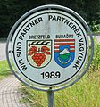
Sign for documentation of the partnership with Budaörs, is in Geddelsbach

Former mayor's office, now a residential building. The residents are still reminded of the time every hour by the bell in the bell tower.
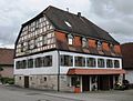
Gasthof zum Lamm

Old wine press
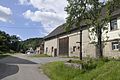
OT Geddelsbacher Hälden


Individual evidence
- ↑ a b Status: December 31, 2018, annual report 2018 of the municipality of Bretzfeld (PDF) municipality of Bretzfeld. Retrieved November 19, 2019.
- ^ Landesarchivdirektion Baden-Württemberg (ed.): Das Land Baden-Württemberg. Official description by district and municipality. Volume 4: Administrative region of Stuttgart, regional associations of Franconia and East Württemberg. Kohlhammer, Stuttgart 1980, ISBN 3-17-005708-1 , pp. 173-179.
- ^ Federal Statistical Office (ed.): Historical municipality directory for the Federal Republic of Germany. Name, border and key number changes in municipalities, counties and administrative districts from May 27, 1970 to December 31, 1982 . W. Kohlhammer, Stuttgart / Mainz 1983, ISBN 3-17-003263-1 , p. 466 .
literature
- Jürgen Hermann Rauser: Brettachtaler Heimatbuch. From the local history of the old communities Adolzfurt, Bitzfeld, Bretzfeld, Dimbach, Geddelsbach / Brettach, Rappach, Scheppach, Schwabbach, Siebeneich, Unterheimbach, Waldbach (= Hohenlohekreis local library. Vol. 14). Jahrbuch-Verlag, Weinsberg 1983.
Web links

Adolzfurt | Bitzfeld | Brettach | Dimbach | Geddelsbach | Rappach | Scheppach | Schwabbach | Siebeneich | Unterheimbach | Waldbach