
Brettach (stove)


The Brettach is a 40-kilometer-long left tributary of the Kochers in northern Baden-Württemberg in the Schwäbisch Hall district , the Hohenlohe district and the Heilbronn district . The medieval Brettachgau was named after the river .
geography
River course
Origin at Mainhardt- Lachweiler and top run
The Brettach begins its course on the Stubensandstein high plateau (Löwenstein formation) of the Mainhardt Forest , less than a kilometer east-southeast of the Mainhardt district of Lachweiler. Here it arises on the northern edge of the Lachweiler Weide forest, northeast of the Schnorrbuckel hill . It flows around this in a west arch and then initially moves south, with the first tributaries from the extensive forest area between Lachweiler and Bubenorbis running towards it. It is crossed by the K 2670, which connects these two parts of Mainhardt, and then begins to deepen. About two kilometers below its source and now about 25 meters below the surrounding hills, it takes up the Krätebach from the left in its upper forest valley and then flows further west in its direction, now in the Mainhardt Formation (Upper Colorful Marl), for their Type locality the village of Mainhardt was named.
From the Kriegenbach to the Mainhardter Mittelmühle
The slopes are now steep, a few short streams run out of Klingen , after a further two kilometers it flows from the right, coming from the area of the Geißelhardt suburb in the north, at two lakes the Benzenbach , the longest of its tributaries on the upper reaches. From here it flows in the Hassberge formation (silica sandstone), the route of the Upper Germanic-Raetian Limes , which is no longer recognizable in nature, crosses the valley, whose narrow floodplain and flatter left slope from the village of Mainhardt are now free of forests. It passes the first two small settlements, the Mainhardter Vorder- and at a side valley mouth from the south the Mittelmühle . Here the slope of the L 1050 from Mainhardt reaches the valley floor and then climbs the right slope. The K 2582 branching off in the valley then follows the river further down, first to the district and municipality border after the Laukenmühle, then as K 2345 further to the middle course.
From the Mittelmühle to Geddelsbach

Below the Mittelmühle, the Brettach turns to the northwest and runs through a very straight, wooded Kerbtal, soon in the loamy Steigerwald Formation (Lower Colorful Marl). The valley road runs noticeably above the river on the right side of the slope because the narrow valley floor leaves no space for it. The very symmetrical bilateral inlets form a chain of conspicuous valley spiders , in the sequence of which the valley slowly widens. The first larger one is located at the Mainhardter Laukenmühle , where for the first time the floor is covered again. From this settlement area to the exit of the valley from the Mainhardt Forest, parts of the upper slopes have repeatedly slipped off, often into the floodplain area, which after the water enters the grave field formation ( Gipskeuper ) for example at the inlet of Streubach and Rohrholzbächle trains and widened more and more. Meanwhile on Bretzfelder Flur, the river reaches the hamlet of Brettach in another valley spider - there is a village with the same name on the Unterlauf - which is surrounded by a more than one square kilometer large clearing island that extends up to at least the middle slopes on both sides. In many places orchards cover the slopes here; Fruit growing is still an important branch of agriculture. On the left slope above the village stands on a spur Maienfels with its castle overlooking the valley, which only has a very steep and narrow Steigensträßchen can be reached from below. After a last forest below, which fills the floodplain, in which the municipality boundary extends from Wüstenrot to the left bank, the Brettach enters the open field from Geddelsbach and turns in the area of the village to the west-north-west; The first vineyards appear here on the right slope.
From Geddelsbach to Scheppach
From Geddelsbach, the Brettach flows in narrow river meanders in its constantly widening floodplain. The right, now about 150 m high Brettachhang is initially covered by large areas of vineyards, only on its upper edge and in the hollows of small hillside streams can you still see forest. The left, soon significantly lower slope, on the other hand, is initially still completely forested. Around the hamlet of Bretzfeld-Hälden on the right halfway up, more and more orchards and hillside meadows are replacing the land-adjusted vineyards. A little further down the valley near Wiesental , the Bernbach flows from the left , its longest tributary with over eight kilometers. He runs, as well as the two and a half kilometers further down the valley at the grown in the area villages Bretzfeld and Adolzfurt also from South inflowing Gabelbach , from many blades on a large wooded area between Eschenau the west and the Steinknickle at Neuhütten in the East. Now the Brettach leaves the mountains of the Mainhardt Forest completely behind and enters the loess hill landscape in front of it. Talstraße is now the L 1090.
From Scheppach to Bitzfeld
After Scheppach, the Brettach continues without loops, turns north, takes the Schwabbach from the left and then flows between the old town of Bretzfeld on the right and its large new building area on the left, both of which avoid the floodplain and are in the area of the lower hill climb. Below the river begins to meander again , and the valley becomes quite narrow again as far as the outskirts of Bitzfeld.
From Bitzfeld to Langenbeutingen
In Bitzfeld the river turns again to the northwest and is soon spanned by the Brettachtalbrücke of the A 6 . Here it now runs, swinging between the impinging slopes on both sides, in a again very narrow meander valley in the Upper Muschelkalk , which some quarries, most of which have already been set up, open up on the right side of the valley. The first and largest is just across the highway bridge; Below Weißlensburg there is another, the pit of which today fills a 3.5 hectare pond. After another double loop of valley and river, which touches the hamlet of Neudeck , the first settlement area of the municipality of Langenbrettach am Ufer, the river reaches the upper edge of the old street village of Langenbeutingen, which lies for about one and a half kilometers at the foot of the hill on the right of the Brettach. From now on the floodplain will widen permanently, and from here it will move to the confluence to the west-northwest.
Lower reaches from Langenbeutingen to Neuenstadt am Kocher
In Langenbeutingen, the Brettach only has a distance of less than 3 km to the Kocher, which runs further to the north, to which it now strives at a very acute angle. Because of this, and because the Riedbach tributary to the Kocher flows between the two, the Seebächle and Landgraben only flow on the remaining stretch of reasonably long tributaries from the right immediately after the village , while there is no lack of more significant left. The first is the Tabach , which flows almost across from the Landgraben . In its wide floodplain, the river now runs in small-scale meanders, mostly between embankments, and the valley itself sometimes shows loops. In a north-easterly one it passes the Langenbrettach village of Brettach on the right slope - the same name as the Bretzfeld hamlet on the upper reaches - then it crosses into the area of the town of Neuenstadt am Kocher, where it is in the shadow of the Brettachtal bridge that crosses the valley at a height of 33 m the A 81 joins the Cleversulzbacher Sulzbach from the left . Then the Limbach flows from the left at the beginning of a second northeast loop of the valley under the ruins of the Helmbund Church , whereupon the Brettach enters the settlement area of Neuenstadt am Kocher . In the city, just before the old town of Neuenstadt built on the pointed mouth of the river, it reaches its last tributary Dahenbach from the left, before it reaches its western tip after a total of 42.1 km at 159.5 m above sea level. NHN flows into the lower reaches of the digester from the left .
Tributaries
- All length and area information according to the state geodata viewer in the web links. The topographic map 1: 25,000 was sometimes used for location information, and generally for height information.
- Water and other landscape-related names from the sources are in italics, whereas descriptive names or parts thereof are not in italics (in this case the water is put in brackets )
The tributaries of the Brettach with a length of more than 5 km are the Bernbach ( left , near Bretzfeld- Wiesental ), the Gabelbach ( left , near Bretzfeld- Scheppach ) and the Sulzbach ( left , near Neuenstadt am Kocher ). Between 3 and 5 km there are still the Benzenbach ( right , near Mainhardt ), the Schwabbach ( left , in Bretzfeld ), the Lindelbach ( right , in Bretzfeld), the Hapbach ( right , near Bretzfeld- Weißlensburg ), the Tabach ( left , near Langenbrettach -Langenbeutingen), the Limbach ( left , near Neuenstadt am Kocher) and the Dahenbach ( left , in Neuenstadt am Kocher)
Origin of the Brettach about 0.7 km east of Mainhardt- Lachweiler at about 482 m above sea level. NHN on the northern edge of the Waldgewann Weide to the corridor.
- Teichfeldgraben , from the left at the edge of the pond field at 465.2 m above sea level. NHN , 0.7 km
- Strutbach , from the left of the K 2670 Ziegelbronn – Bubenorbis at 460.7 m above sea level. NHN or a little less, 0.8 km
- Krätebach , from the left at the western bend of the Brettach in the community forest , 1.2 km
- Stockbach , from the left at the foot of the Langäcker , 0.8 km
- Riegenhofbach , from the left north-northwest of the Riegenhof, 0.6 km
- Wannenbach , from the left east-northeast of the Mainhardter Siedlungsstraße Keltenring, 0.5 km
- Odenbach , from the right from the Ströllersklinge at 403.5 m above sea level. NHN , 1.0 km
-
 At the confluence of the following there is a pond of 0.4 ha, on the left side of the Brettach opposite one of 0.2 ha
 - Benzenbach , from the right by the ponds, 3.4 km
- (Bach aus der Fuchsklinge ), from the left in front of the Mainhardter Vordermühle, 0.7 km
- Röhrichbächle , from the left at the Mainhardter Mittelmühle, 2.0 km
- (Bach through the deep blade ) at the northwest bend of the Brettach, from the left, 1.0 km
- (Klingenbach from the Mainhardt- Gailsbacher Rotäckern ), from the right, 0.6 km
- Lohklingenbach , from the left to 354.7 m above sea level. NHN , 2.1 km
- Moselbuschbächle , from the right, 1.0 km
- Steinbrückenbächle , from the right through the blade at the Mainhardter Laukenmühle to 340.1 m above sea level. NHN , 2.0 km
- Lumpenlochbächle , from the left immediately after the Laukenmühle, 2.3 km
-
Pond at the mouth of 0.2 ha, now in Bretzfeld municipality
- Streubächle , from the left to 317.8 m above sea level. NHN , 2.5 km
- Rohrholzbächle , from the right from the Kalten Klinge , 1.5 km
-
Two ponds in the cane (field name) on the right of the roof of the roof of less than 0.2 ha
-
Pond on the right of the Brettach at a little under 301.7 m above sea level. Below 0.1 ha
- (Bach from the Bretzfeld- Brettacher Allmend ), from the left, 1.2 km
- (Bach from the Holderklinge ), from the right, 1.7 km across from Brettach on a field path bridge
- Rappenbach , from the left at the Brettach Bridge from Brettach at 286.7 m above sea level. NHN , 2.4 km
- Kohlhaubächle , from the right, 1.2 km
- (Hangbach down the southern Vordere Bockshalden ), from the left, 0.6 km
- (Hangbach down the Hintere Bockshalden ), from the left at the edge of the Rossmähder , 0.5 km
- (Bach from the south foot of the castle stable Gleichen ), from the right at the Brettachbrücke of the Waldstraße to Wüstenrot -Oberheimbach at 265.5 m above sea level. NHN , 0.9 km
- (Brook from below the Zollknocks ), from the right in the Bretzfeld- Geddelsbacher Gewann Steinbühl , 1.3 km
- (Bach from the Fleischhau along Buchhorner Straße), from the right in Geddelsbach across from the Stöckerswiesen , 0.9 km
- (Stream down from Zankhölzle ), from the left to 238.2 m above sea level. NHN , 1.0 km
- Landgraben (!), From the right at Bretzfeld-Hälden, 0.7 km
- Bernbach , from the left at Bretzfeld- Wiesental at 223.5 m above sea level. NHN , 8.6 km and 17.9 km²
- (Graben from Neuberg down), from the right at the valley forest Sollert at 219.4 m above sea level. NHN , 1.2 km
- (Departure to the right and backflow of the Adolzfurt Mühlkanal), 0.9 km
- Gabelbach , from the left in Bretzfeld- Scheppach next to Mühlstrasse, 7.0 km
- Eschelbach , from the left in Bretzfeld-Scheppach just before the Brettachbrücke to Adolzfurt, 2.0 km
- (Exit to the left of the mill ditch to the mill in Bretzfeld- Rappach ), which then flows into the following, 1.3 km
- Schwabbach , from the left in Bretzfeld between the sports field in the west and the old town in the east, 4.9 km and 21.6 km²
- Lindelbach , from the right on the northern edge of Bretzfeld at 206.4 m above sea level. NHN , 3.0 km
- Herrschichgraben , from the right, 0.6 km
- Verrenbach , from the right in Bitzfeld north of Heilbronner Strasse, 2.4 km
- Hapbach , from the right at the quarry before Bretzfeld- Weißlensburg at 197.8 m above sea level. NHN , 3.2 km
- Laubach , south of Weißlensburg from the left, 0.6 km
- Rimmlingsbächle , from the right to 194.3 m above sea level. NHN , 2.6 km
-
In the lower corner of the mouth of the previous one a quarry pond of 3.5 ha
- (Exit to the left of the Mühlkanal to Langenbrettach -Neudecker Mühle), which flows into the following, 0.2 km
- (Stream through Neudeck), from the left, 1.2 km
-
On the right of the Brettach before Langenbrettach-Langenbeutingen a quarry pond of 0.3 ha
- Goppengrundbach , from the right through Langenbeutingen, 2.0 km
- Binsachbach , from the left between the sports field and Bad von Langenbeutingen, 1.4 km
- (Exit to the right and backflow of the Mühlkanal to Langenbeutinger Untermühle), 0.2 km
- Seebächle , from the right into the Mühlkanal, 1.8 km
- Landgraben (!), From the right at Gewann Brühl , 2.2 km
- Tabach , from the left opposite the Brühl at 181.2 m above sea level. NHN , 3.0 km
- (Gap between Hägnach and Reiter height ) from the left with respect to the Langenbrettach-Brettnacher sports field to 177.9 m above sea level. NHN , 0.7 km
- (Exit to the right and backflow of the canal to the Langenbrettach-Brettacher hydropower plant), 0.2 km
- Schafgraben , from the right through Brettach into the Mühlkanal, 0.8 km
- Sulzbach , from the left under the Brettachtal bridge of the A 81 at 177.9 m above sea level. NHN , 5.7 km
- Limbach , from the left at the Helmbunder Kirchle at 165.7 m above sea level. NHN , 3.8 km
- Dahenbach , from the left in Neuenstadt am Kocher , 4.9 km
Mouth of the Brettach after a run of 42.1 km near the Kocherbrücke in Neuenstadt am Kocher at just under 159.5 m above sea level. NHN from the left into the stove .
Districts, municipalities and residential areas
Places and places to live on the Brettach with their community and district affiliations, from the source to the mouth. Only the entries with the lowest nesting level are on the river bank.
- Mainhardt municipality
- Vordermühle ( living space, right )
- Mittelmühle ( living space, left )
- Laukenmühle ( living space
- Wüstenrot municipality
- Without places on the run, briefly left neighbors opposite the Bretzfeld area
Hohenlohe district
- Bretzfeld municipality
- Geddelsbach ( hamlet, mostly on the right )
- Wiesental , ( single house in Adolzfurt, left )
- Scheppach ( village, left )
- Adolzfurt ( village, opposite the previous one, right )
- Bretzfeld ( village, main town )
- Bitzfeld ( village )
- Weißlensburg ( hamlet )
Heilbronn district
- community Langenbrettach
- Neudeck ( hamlet )
- Langenbeutingen ( right )
- Brettach ( Dorf am Unterlauf, right )
- City of Neuenstadt am Kocher
Flood protection
Significant flood damage has occurred time and again along the Brettach over the past decades. To contain the risk of flooding, a flood protection concept was developed for the course of the Brettach. This protection provides for a total of twelve flood retention basins in the valley. Two existing basins at the Lindelbach in Bretzfeld were taken over by the Neuenstadter Brettach water board in 1988 from the municipality of Bretzfeld, two more above Adolzfurt were built from 2004, a fifth (also above Adolzfurt) has been under construction since summer 2008, and a sixth near Eschelbach should be from spring To be erected in 2009.


In the case of flood retention basin A1, which is located 600 m above Adolzfurt, the impoundment in the retention area only begins when the Brettach flows over 2.5 m³ per second due to a suitable construction of the culvert structure. If the inflow falls below this, the retention area empties again. Only in the event of a so-called 50-year or even worse flood event will the entire 22 hectares of the designated reservoirs flood. During the flood-free period, the agricultural areas in the storage space can be used as before. Damage to property and plants in the storage space caused by flooding will be compensated by the association.
To relieve the flooding of the retention basin itself, an overflow dam of 200 meters in length in the dam section north of the Brettach serves. In extreme events, this can discharge around 138 cubic meters of runoff per second with a freeboard of 1.4 m .
- Data
Catchment area 57.8 km²
Ordinary flood
retention area 427,000 m³ Damming area at HQ50 22 ha
dam crest length 440 m
Maximum dam height above valley floor 6.5 m
dam volume 37,000 m³
environment
flora
Most of the slopes on the upper reaches of the Brettach are forested. From the place Brettach the Brettach flows along meadows and fields. The slopes are partly wooded or laid out as vineyards. The Brettach spice apple comes from the Langenbrettach district of Brettach .
fauna
The Brettach with its valley is a habitat for many animal species. So come on arthropods u. a. Ground beetles , stone flies , banded dragonflies , feathered dragonflies and blue-green damselfish , edible , stone and jackdaw crabs . Bird species include dipper , kingfisher and gray wagtail . The small mammals are beaver , otter , Bisam- and brown rat and pointed chisels and bat species that amphibians and reptiles by ringed and dice snake or salamander and newt and the fish by Bach and rainbow trout , bullhead and lamprey represented.
Attractions
- Maienfels Castle in the Wüstenrot district of Maienfels , above the Brettach Valley near Bretzfeld-Brettach .
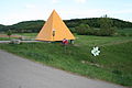
- Landart Bretzfeld 2012, Kunst am Brettachtal - cycle path. The art project Landart Bretzfeld was installed in 2012 between the Bürgerwiese in Bretzfeld, the former powder mill in Adolzfurt and the Talaue in the direction of Geddelsbach .

Egyptian pyramid, carmine red, by Hans A. Graef and the two giants by Wolfgang Steck
Egyptian pyramid, sun yellow, by Hans A. Graef

Flower meadow by Elfriede Schwaderer


See also
Picture gallery

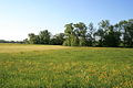
Upper Brettachtal near Mainhardt

View of the Brettachtal from Maienfels

The Brettach estuary, redesigned in 2008, in Neuenstadt am Kocher
The lower Brettachtal near Langenbeutingen

The flood ford near Langenbeutingen


Comments and individual evidence
- ↑ Wolf-Dieter Sick : Geographical land survey: The natural space units on sheet 162 Rothenburg o. D. Deaf. Federal Institute for Regional Studies, Bad Godesberg 1962. → Online map (PDF; 4.7 MB)
- ↑ Josef Schmithüsen : Geographical land survey: The natural space units on sheet 161 Karlsruhe. Federal Institute for Regional Studies, Bad Godesberg 1952. → Online map (PDF; 5.1 MB)
- ↑ Interpolated according to the contour lines of the TK25.
- ^ According to the data set of the LUBW-FG10.
- ↑ Sum of the sub-catchment areas in LUBW-GEZG.
- ^ German Hydrological Yearbook Rhine Region, Part I 2009 State Institute for Environment, Measurements and Nature Conservation Baden-Württemberg, p. 128, accessed on January 22, 2016 (PDF, German, 1.85 MB).
- ↑ Only a narrow, wooded, completely uninhabited tongue of the municipal area of Wüstenrot extends into the valley to just over the river.
- ↑ a b c d e f g h i j k l m n o p q Number entry in black on the TK25.
- ↑ Number entry in black on TK25, this could also mean street level.
- ↑ Number entry on TK25, perhaps with reference to the level of the passing street.
- ↑ Between Brettach and Geddelsbach on a piece of floodplain forest less than a kilometer long. Some maps also show small community gussets on the right side of the desert red, but this only seems to be due to an inexact reproduction of the course of the river; the course according to the hydrologically more up-to-date and more precise LUBW-FG10 (see under the web links) coincides here with the municipality boundary.
-
↑ State funds flood retention basin A1 in the Adolzfurt district of the Bretzfeld municipality with 5.14 million euros ( page no longer available , search in web archives ) Info: The link was automatically marked as defective. Please check the link according to the instructions and then remove this notice. . Press release of the Ministry of the Environment Baden-Württemberg from September 20, 2007 (accessed on May 12, 2008) Tanja Gönner and District President Johannes Schmalzl give the green light for flood retention basin Eschelbach ( page no longer available , search in web archives ) Info: The link was automatically marked as defective . Please check the link according to the instructions and then remove this notice. . Press release of the Ministry of Environment Baden-Württemberg from November 27, 2008 (accessed December 21, 2008).
- ↑ To the Brettacher apple. Archived from the original on March 1, 2014 ; Retrieved May 12, 2008 .
- ↑ Program: the basis of life for the environment and its protection (BWPLUS)
- ↑ Website for the Landart Bretzfeld concept (accessed on May 6, 2012)
literature
- "TK25": topographic map 1: 25,000 Baden-Württemberg north, single-sheet cut the maps No. 6721 Bad Friedrichshall, No. 6722 Hardhausen am Kocher, No. 6822 Obersulm, No. 6823 Pfedelbach, No. 6923 Sulzbach ad Murr ( for the River course, for the catchment area additionally:) No. 6821 Heilbronn, No. 6922 Wüstenrot.
- "GK50": Geological map of the Swabian-Franconian Forest Nature Park 1: 50,000, published by the State Office for Geology, Raw Materials and Mining Baden-Württemberg, Freiburg i. Br. 2001.
- Yvonne Tscherwitschke: Wet feet on the lower Brettach . In: Heilbronn voice . January 28, 2011 ( at Stimme.de ).
Web links
- Map of the course and catchment area of the Brettach : State Institute for the Environment Baden-Württemberg (LUBW) ( information )
-
Geoportal Baden-Württemberg ( information ), especially with the partial maps / layers
- the State Institute for the Environment, Measurements and Nature Conservation Baden-Württemberg (LUBW)
- "LUBW-FG10": River 1: 10,000
- "LUBW-SG10": Standing water 1: 10,000
- "LUBW-GEZG": water catchment areas
- of the State Office for Geology, Raw Materials and Mining of the State of Baden-Württemberg (LGRB)
- "LGRB-GÜK300": Geological overview map 1: 300,000
- the State Institute for the Environment, Measurements and Nature Conservation Baden-Württemberg (LUBW)
- Criteria for the design, operation and maintenance of dam and retention systems to ensure ecological permeability (PDF), interim report on the occasion of the BWPLUS on February 21 and 22, 2006 in the Karlsruhe Research Center