
Burgstall same
| Castle Gleichen | ||
|---|---|---|
 Stone remains of Gleichen Castle |
||
| Creation time : | 1100 to 1200 | |
| Castle type : | Höhenburg, spur location | |
| Conservation status: | Burgstall | |
| Standing position : | Reichsburg | |
| Place: | Superior equals | |
| Geographical location | 49 ° 8 '8.2 " N , 9 ° 31' 9.5" E | |
| Height: | 467.2 m above sea level NN | |
|
||

The Gleichen Castle is an Outbound Spur castle on a 467.2 m above sea level. NN high, conical hump on a western spur tip to the right above the Brettachtal, which is moving north-northwest here . The castle hill is about 1.8 km north-northeast of Maienfels Castle, which stands on the left-hand side up the valley, in the area of today's village of Obergleichen in the Mainhardt Forest , in the area of the municipality of Pfedelbach . Towards the Brettachtal, to the west, the mountain drops steeply. On a high plateau, east and northeast of the castle complex , are the villages of Ober- and Unterleichen , which are dominated by the castle hill. The hill is popularly called Schlossberg.

description
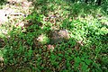
The 34 × 35 meter, leveled castle plateau towers over the village of Obergleichen by around 15 meters and is surrounded on three sides by an artificial ring wall with a moat . The moat and the rampart, some of which are up to 2 meters high, are clearly visible. A ruin or even remnants of masonry are no longer there. Presumably, the castle ruins were used as a quarry by the residents of the neighboring towns after their departure and the masonry was removed over the centuries as a cheap building material. However, stone rubble and remnants of bricks suggest that there used to be permanent buildings on the castle plateau. A recognizable depression on the site could indicate a foundation, and an existing mound is likely to be the remains of a building.
history
The strategically excellent location of the castle hill and the wide view over the Mainhardt forest and the Löwenstein mountains allow the conclusion that the castle played an important role at the time it was built. The castle was probably built as an imperial castle in the course of the Hohenstaufen administrative reform in the 12th century . It was the seat of the Gleichen until it fell into disrepair in 1416 . It and its owners and presumed builders, the lords of Gleichen, were first mentioned in a document in 1294 as "de Gliche". Otherwise very little is known about this family. After their extinction or their departure, the Lords of Limpurg were probably the first owners of the facility. Between 1298 and 1308 came peers by King Albert I in the possession of the Lords of Lowenstein . In 1332 there is another mention of the castle in a document from Emperor Ludwig . After that, the castle changed hands several times and finally passed into the possession of the Hohenlohe- Bartenstein house in 1416 , which remained its owner until the complex fell into disrepair.
Until 1994 there was an elevated tank of the Gleichener drinking water supply on the castle grounds.
In Gleichen, Burgstrasse and Am Burgrain are reminiscent of the former castle.

Remains of the Gleichen Castle
A stone from Burg Gleichen

Stone ball, found on the Schlossberg in Gleichen in 1970


Individual evidence
- ^ Pfedelbach municipality. Former castle Gleichen. pro-region.de.
- ↑ Frank Buchali, Marco Keller: Pfedelbach-equals. Burgstall Gleichen - castle hill in the Löwenstein mountains. (PDF; 304 kB).
- ^ Burgstall near Pfedelbach-Gleichen. (PDF; 14 kB) pro-region.de history


Wasserburg Adolzfurt | Burgstall Altgabelstein | Altneufels castle ruins | Aschhausen Castle | Bartenau Castle | Berlichingen Castle | Bieringen Water Castle | Buchenbach Castle | Orangery Castle Cappel | Charlottenschlößchen | Burgstall Eberbach | Burgrest Edelmannshof | Burgstall Eselsburg | Eyb Castle | Forchtenberg ruins | Friedrichsruhe Palace | Burgstall Gabelstein | Garnberg Castle | Burgstall Gleichen | Gommersdorf Castle | Burgstall Gruningen | Ruin Günzburg | Burgstall Heidenschlössle | Heimberg Castle | Hermersberg Castle | Burgstall Hohenacker | Burgstall Hornberg | Ingelfingen Old Castle | Ingelfingen New Castle | Burgrest Jagstberg | Burgrest Kocherstein | Krautheim Castle | Residenzschloss Kupferzell | Ljubljana Castle | Lichteneck Castle | Meßbach Castle | Mulfingen Castle | Nagelsberg Castle | Neuenstein Castle | Neufels Castle | Neunstetten Castle | Öhringen Castle | Ottohausen Castle | Pfedelbach Castle | Rossach Castle | Lower lock | Burgstall Schlossbuckel | Sindringen Castle | Ruin stone | Stetten Castle | Urhausen Castle | Waldenburg Castle | Waldzimmer castle ruins | Burgstall Wallburg | Ruin frame