Burgstall Gabelstein
| Burgstall Gabelstein | ||
|---|---|---|
|
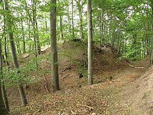
View from the south of the main castle (center) and the neck ditch (right) |
||
| Creation time : | before 1253 | |
| Castle type : | Höhenburg, spur location | |
| Conservation status: | Burgstall, moats and ramparts | |
| Standing position : | Noble | |
| Place: | Michelbach am Wald | |
| Geographical location | 49 ° 9 '35.4 " N , 9 ° 34' 23.1" E | |
| Height: | 431.3 m above sea level NN | |
|
|
||
The Postal Fork Stone is an Outbound Spur castle on the escarpment of the Waldburger mountains . It is located near the village of Michelbach am Wald in the city of Öhringen in the Hohenlohe district in Baden-Württemberg .
location
The Burgstall is located just under 2.5 km southeast of Michelbach at 431.3 m above sea level. NN at the tip of an approximately 800 m long western mountain spur of the wooded plateau, which is encompassed in the south and west by the valley of the upper Rechtenbach . In the north, the terrain slopes down to the Hohenlohe plain , in which the eponymous Michelbach runs parallel only before the shift stage and then strives through the village to the Ohrn in the northwest, after it has taken up the Rechtenbach on its southern edge . The Burgplatz is about 160 m above the Michelbachlauf. From the village and stream, the K 2387 climbs the north slope in serpentines in the direction of Obersteinbach; From the point where it reaches the eaves height in the east, the Burgstall can be reached via a forest path.
history
In 1253 a knight "Herr Gabele" is mentioned for the first time, in 1260 a Zürich von Gabelstein, also called "von Stetten" , is mentioned and in 1322 a Gernot von Gabelstein. 1327 sold Zurich Fork stone the bailey to the Lords of Hohenlohe . The remaining parts of the castle belonged to several owners, so it was an inheritance castle .
From 1350 the entire castle was owned by the Hohenlohe family and fell into disrepair after it was no longer strategically interesting. Since the castle later served as a robber barons nest, it was razed by the owners . The church in Michelbach was built in 1753 with the stones of the castle.
description
The strategically well-located castle, of which only moats and ramparts testify, had a core castle located on the top of the mountain spur of the castle plain , which had a spring at about 452 m above sea level. NN , which today is still called the castle fountain, supplied water from the mountain plateau at the spur approach, a bailey with a tower, a forecourt and a 10 meter deep and 15 meter wide neck ditch .
Web links
- Gabelstein Castle on the site burgen-web.de (PDF; 680 kB)


