Plaster Keuper

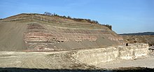
The Gipskeuper is a historically widespread geological mapping unit of the lower section of the Middle Keuper of the Germanic Triassic . The gypsum keuper is mainly formed from colorful, predominantly reddish clay stones with deposits of gypsum , anhydrite and rock salt layers . Due to the solubility of the sulfate salt and Rocks ( Subrosion ) Gipskeuper environments are frequently Subrosionsformen as sinkholes and sinkholes characterized. Keuper gypsum currently covers around half of Germany's natural stone gypsum requirements. Gypsum keuper deposits are widespread in the subsurface of the North German and Thuringian basins , in the Steigerwald , the Filder Plain , the Franconian and Swabian Alb and on the edge of numerous low mountain ranges. The fossil record in the gypsum keuper is very low.
Climate and deposit conditions

In the Middle Keuper, continental deposit conditions prevailed in Europe . Due to a general uplift in Central Europe since the beginning of the Keuper, the influence of the sea has been greatly reduced. At the edges of the continental, partly brackish - lagoon sedimentary basin , increased sediment inputs from surrounding high areas, such as from the Vindelician Sill in the southeast, were observed. In the shallow lagoon areas , carbonates , sulphates (gypsum, anhydrite) and rock salts could be deposited in warm and dry climatic conditions . At times these shallow lagoon areas were crossed by meandering rivers, which deposited sandy sediments that can be observed today as sandstone inclusions within the gypsum keuper. In general, the predominantly red rock colors, dry cracks and the presence of gypsum crusts and salt deposits indicate the arid and dry climatic conditions.
History of exploration
The term "Gipskeuper" was introduced in 1866 by Carl Wilhelm von Gümbel . Under this term, Gümbel summarizes the three lowest strata of the Middle Keuper , the Grundgyps (today Grabfeld Formation ), the reed sandstone (today Stuttgart Formation ) and the Berggyps (today Steigerwald Formation ). The exploration of this rock formation goes hand in hand with the skyrocketing consumption of gypsum towards the end of the 19th century, when there was a great need for gypsum for stucco work in Germany during the founding period .
Lithologies
In northern Germany, the gypsum keuper is formed from a sequence of layers of red, green and gray clay marl stones and dolomitic clay stones, in which gypsum and anhydrite can be embedded in layers . In Schleswig-Holstein , Emsland and the Lower Weser , the sequence of layers contains two salt deposits of 250-300 m thickness, which are viewed as partially resedimented Zechstein salts in deeply deepened marginal depressions of perforated salt diapirs . In Mecklenburg-Western Pomerania , the gypsum keuper, which is on average 200-320 m thick , is subdivided into two separate strata - the lower and upper gypsum keuper - by the 25-90 m thick sandstone reed . The reed sandstone deposited in river channels is made up of sandstones , greywacke and breccias . The width of the fluvial channels in northern Germany varies between 1 and 15 km. Most of them are oriented NE-SW or NW-SE. The reed sandstone is widespread in what is now Central Europe, from Scandinavia , southern Poland to northern Germany, the Thuringian Basin to southern Germany.
The Lower Gypsum Keuper is built in northern Germany from an alternating layer of colored, red, green, gray clay stones in which bulbous or massive layers of anhydrite are inserted. Dolomitic deposits occur less often and rock salt deposits can be found in the higher profile section . In Mecklenburg-Western Pomerania, the thickness of the Upper Gipskeuper fluctuates mainly depending on the influence of the salt tectonics ( halokinesis ) on the subsoil . On some tectonic thresholds and high altitudes in the subsurface, e.g. B. the Rügen threshold and the southwest Mecklenburg high altitude, the Obere Gipskeuper is completely absent. The Obere Gipskeuper is formed in Northern Germany from alternating layers of brownish-red clay stones with bulky and massive layers of anhydrite. In the highest profile sections, a 20 m thick anhydrite bank is embedded, which corresponds to the Thuringian Heldburg gypsum. Rock salt is only known in the Upper Gipskeuper from the area around Grevesmühlen and Mirow .
In East Westphalia and Hesse the gypsum keuper sediments reach a thickness of 160 to 190 m (Herford-Bielefeld area) and 100 to 140 m ( Hessian basin ), respectively . In the direction of the mainland at that time, such as the Rhenish Slate Mountains and the Harz Mountains, the thicknesses decline rapidly.
In Thuringia, the Lower Gipskeuper can be divided into four sections:
- Upper marl gypsum
- Gray marl layers
- Middle gypsum marl (upper part of the myophoric layers): gray marls, in the upper profile section gray and red marls with gypsum and anhydrite
- Low gypsum marl (lower part of the Myophorienschichten): 5-12 m greenish-gray marl with gypsum deposits (ground gypsum) and a galena -Bank at the top of the lower gypsum marl
In Thuringia, the Obere Gipskeuper is separated from the Lower Gipskeuper Successes by the maximum 60 m thick reed sandstone. The Obere Gipskeuper in Thuringia can also be divided into 4 sections.
- Heldburg marl: gray clay marl with plaster deposits
- Colorful marls : red to red-brown, subordinate green and gray marls with layers of plaster of paris
- Lehrbergschicht : red marls, alternating with green and gray marls and a characteristic fauna (including the snail Promathilda theodorii )
- Red wall : red and purple clay stones alternating with green clay stones and predominantly tuberous plaster layers
In the central Thuringian basin there are also thin rock salt deposits.
In some parts of southern Germany, the compact gypsum stores are not developed. Due to the characteristic weathering of the mudstones to form grus and rock debris, such rocks are known locally as "Leberkiese" ( liver from old German for mountain, ie "Grus from the mountain").
Stratigraphic classification
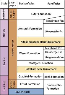
The stratigraphic classification of the gypsum keuper varies depending on the geographical facies area. The modern stratigraphic correlation is carried out according to the specifications of the lithostratigraphic lexicon of the Federal Institute for Geosciences and Raw Materials (Litholex):
Württemberg and Hessian plaster keuper

The gypsum keuper in the Württemberg region was first described by Friedrich von Alberti in 1834 . In the Hessian-Württemberg area, the gypsum keuper begins with the first gypsum-bearing layers above the "Swabian border dolomite", includes the grave field formation of the Middle Keuper and extends to the base of the reed sandstone of the Stuttgart formation . The Württemberg and Hessian gypsum keuper thus covers a stratigraphic range from the Ladinium / Carnian border to the Lower Carnian (lower part of the Middle Keuper, 235 to 332 million years old).
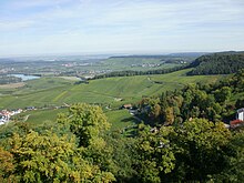
The gypsum keuper is particularly widespread in this region in the Württemberg part of the Swabian-Franconian stepland and in the Hessian depression .
Badischer Plasterkeuper
The first descriptions of the Baden gypsum keuper were made in 1896 by Hans Thürach and summarized in 1916 by Wilhelm Deecke . The Baden gypsum keuper sets at the base of the Böhringen sulphate (Erfurt Formation) directly above the Baden border dolomite and stratigraphically extends to the first sandstone within the Löwenstein Formation . The gypsum keuper sedimentation here covers a period from the Upper Ladinian to the Middle Norian . (235-215 million years ago). In Baden, plaster marl deposits are widespread in the Swabian-Franconian stepland and in the Upper Rhine Valley .
Franconian gypsum keuper
The Franconian Gipskeuper was first described in 1866 by Carl Wilhelm von Gümbel. In Franconia, the gypsum keuper begins with the first gypsum-bearing layers at the top of the so-called Franconian Grenzdolomites ( Erfurt Formation ) and extends here to the base of the first sandstones of the Hassberge Formation . In the area of the edges of the mainland sills at that time, such as the Vindelizisches Land , the sedimentation conditions were somewhat different ( Benk formation ). In the Franconian area , the stratigraphic range of the Gipskeuper encompasses the Grabfeld Formation to the Steigerwald Formation , including the special facies of the Benk Formation. The gypsum keuper sediments thus cover a period from the Upper Ladinian to the Middle Carnian (235 to 230 million years). The gypsum keuper is widespread in this region, especially in the low mountain ranges, especially in the Franconian part of the Swabian-Franconian stepland.
Thuringian plaster keuper
The gypsum keuper was first described in Thuringia in 1839 by Heinrich Credner . In Thuringia, the gypsum keuper starts directly in the hanging wall of the Thuringian border dolomite (Erfurt formation), which is an equivalent deposit to the Franconian border dolomite. The clayey saline facies of the Gipskeuper range in Thuringia to the so-called Heldburg gypsum . The period of deposition of the gypsum keuper thus covers the entire Carnian (235 to 221 million years).
In Thuringia, the gypsum keuper is widespread on the edge of the Thuringian low mountain range and in the Thuringian basin.
North German and Westphalian plaster keuper
The north-west German gypsum keuper, which occurs mostly on the edges of the low mountain range, such as the Weserbergland as well as in the underground of the North German lowlands and the Leinegraben , was first described in 1892 by Robert Kluth for the Weserbergland and Alexander Tornquist in 1894 for the area around Göttingen .
The North German and Westphalian gypsum keuper encompasses the entire Middle Keuper (Grabfeld, Stuttgart and Weser formations from 235 to 221 million years ago). The average thickness of the gypsum keuper deposits in northern and western Germany is 250 to 400 m. In tectonic rift structures, much greater thicknesses have been deposited in places, in the Glückstadt Graben on the Lower Elbe even over 4500 m.
Individual evidence
- ^ Author collective: Lexicon of Geosciences. Volume II, Spektrum Akademischer Verlag, Heidelberg / Berlin 2000, ISBN 3-8274-0421-5 , p. 321.
- ^ Edgar Nitsch: Word stories from the Keuperstratigraphie. Part III: Plaster of paris, base plaster and mountain plaster. In: Journal of the German Geological Society. Volume 155, Stuttgart 2005, p. 187.
- ^ Geological Service North Rhine-Westphalia: Geology in the Weser and Osnabrück Bergland. Krefeld 2003, ISBN 3-86029-932-8 , p. 55.
- ^ Carl Wilhelm von Gümbel: The geognostic conditions of the Franconian Triassic region. In: Bavaria. Regional and folklore of the Kingdom of Bavaria. Volume 4, Munich 1866, p. 3 ff.
- ^ Edgar Nitsch: Word stories from the Keuperstratigraphie. Part III: Plaster of paris, base plaster and mountain plaster. In: Journal of the German Geological Society. Volume 155, Stuttgart 2005, p. 187.
- ^ Roland Walter: Geology of Central Europe. 5th edition. Schweizerbart'sche Verlagbuchhandlung (Nägele and Obermiller), Stuttgart 1992, ISBN 3-510-65149-9 , p. 85.
- ↑ a b c Gerhard Beutler: Trias. In: Gerhard Katzung (Ed.): Geology of Mecklenburg-Western Pomerania. Schweizerbart'sche Verlagbuchhandlung (Nägele and Obermiller), Stuttgart 2004, ISBN 3-510-65210-X , p. 148 f.
- ^ Geological Service North Rhine-Westphalia: Geology in the Weser and Osnabrück Bergland. Krefeld 2003, ISBN 3-86029-932-8 , p. 55.
- ↑ a b c Joachim Dockter, Rolf long leg: keuper. In: Gerd Seidel (Ed.): Geology of Thuringia. E. Schweizerbart'sche Verlagbuchhandlung (Nägele and Obermiller), Stuttgart 1995, ISBN 3-510-65166-9 , p. 340 ff.
- ^ Roland Walter: Geology of Central Europe. 5th edition. Schweizerbart'sche Verlagbuchhandlung (Nägele and Obermiller), Stuttgart 1992, ISBN 3-510-65149-9 , p. 336.
- ^ Edgar Nitsch: Word stories from the Keuperstratigraphie. Part III: Plaster of paris, base plaster and mountain plaster. In: Journal of the German Geological Society. Volume 155, Stuttgart 2005, p. 188.
- ^ Friedrich von Alberti: Contribution to a monograph of the colorful sandstone, shell limestone and keupers and the connection of these structures to a formation . Cotta, Tübingen 1834. (1998, ISBN 3-00-003351-3 )
- ↑ Litholex: Gipskeuper (of Württemberg). Retrieved December 26, 2019 . on litholex.bgr.de
- ↑ Hans Thürach: Explanations on sheet Sinsheim (No. 42) . Geol. Specialct. Ghzgt.Baden, Erl. Bl. 42, Heidelberg 1896, OCLC 61811695 .
- ^ Wilhelm Deecke: Geology of Baden. Volume 1, Borntraeger, Berlin 1916, DNB 36548945X .
- ↑ Litholex: Gipskeuper (Baden). Retrieved December 26, 2019 . on litholex.bgr.de
- ↑ Litholex: Gipskeuper (Frankish). Retrieved December 26, 2019 . on litholex.bgr.de
- ^ Heinrich Credner: Geognostic description of the ridge between Gotha and Arnstadt. In: New yearbook for mineralogy, geognosy, geology and Petrekakten customer. Stuttgart 1839, pp. 379-403.
- ↑ Litholex: Gipskeuper (Thuringian). Retrieved December 26, 2019 . on litholex.bgr.de
- ↑ Robert Kluth: The Gypskeuper middle-Weser area. Diss. Univ. Goettingen. Göttingen 1894, 47 pp.
- ↑ Alexander Thornquist: The Gypskeuper in the area of Göttingen . Diss. Univ. Goettingen. Hofer, Göttingen 1892, 37 pp.
- ↑ Litholex: Gipskeuper (Prussian). Retrieved December 26, 2019 . on litholex.bgr.de
- ↑ Litholex: Middle Keuper. Retrieved December 26, 2019 . on litholex.bgr.de
literature
- Gerhard Beutler: Lithostratigraphy. In: German Stratigraphic Commission (Ed.): Stratigraphie von Deutschland IV - Keuper. (= Courier Research Institute Senckenberg. Volume 253). Frankfurt am Main, pp. 65-84. ISSN 0341-4116
- German Stratigraphic Commission (ed.): Stratigraphie von Deutschland IV - Keuper . - Courier Research Inst. Senckenberg, Volume 253: Frankfurt am Main 2005, p
- Carl Wilhelm von Gümbel (1866): The geognostic conditions of the Franconian Triassic area. In: Bavaria. Regional and folklore of the Kingdom of Bavaria. Volume 4, Straub, Munich 1866, pp. 3-77.
- Otto Grupe: On the stratigraphy of the Triassic in the area of the upper Weser valley. In: Jahresber. Lower Saxony. Geol. Ver. Volume 4, Hannover 1911, pp. 1–102.
- Edgar Nitsch: Word stories from Keuperstratigraphy. Part III: Plaster of paris, base plaster and mountain plaster. In: Journal of the German Geological Society. Volume 155, Stuttgart 2005, pp. 187-193.
- Edgar Nitsch: Word stories from Keuperstratigraphy. Part I: Keuper. In: Journal of the German Geological Society. Volume 155, Stuttgart 2005, pp. 175-179.
- Edgar Nitsch: The Keuper in the Stratigraphic Table of Germany 2002: Formations and consequences. In: Newsletters on Stratigraphy. 41 (1-3), Stuttgart 2005, pp. 159-171 ISSN 0078-0421
- Carl Zelger: Geognostic migrations in the area of the Triassic Franconia . Staudinger, Würzburg 1867.
- Joachim Dockter, Rolf Langbein: Keuper. In: Gerd Seidel (Ed.): Geology of Thuringia. E. Schweizerbart'sche Verlag Buchhandlung (Nägele and Obermiller), Stuttgart 1995, ISBN 3-510-65166-9 , pp. 332-344.
Web links
- Litholex of the Federal Institute for Geosciences and Raw Materials , interactive input, accessed on March 18, 2013


