
Bretzfeld
| coat of arms | Germany map | |
|---|---|---|

|
Coordinates: 49 ° 11 ' N , 9 ° 26' E |
|
| Basic data | ||
| State : | Baden-Württemberg | |
| Administrative region : | Stuttgart | |
| County : | Hohenlohe district | |
| Height : | 210 m above sea level NHN | |
| Area : | 64.7 km 2 | |
| Residents: | 12,651 (Dec. 31, 2018) | |
| Population density : | 196 inhabitants per km 2 | |
| Postal code : | 74626 | |
| Primaries : | 07946, 07945 | |
| License plate : | KÜN, EAR | |
| Community key : | 08 1 26 011 | |
| LOCODE : | DE BZF | |
| Community structure: | Main town and 12 districts | |
| Address of the municipal administration: |
Adolzfurter Strasse 12 74626 Bretzfeld |
|
| Website : | ||
| Mayor : | Martin Piott | |
| Location of the municipality of Bretzfeld in the Hohenlohe district | ||
  |
||

Bretzfeld is a municipality in the Hohenlohe district in the Franconian north-east of Baden-Württemberg . It belongs to the Heilbronn-Franken region . Bretzfeld is called "The Gate to the Hohenloher Land ".
geography
Geographical location
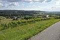
Bretzfeld is the westernmost municipality in the Hohenlohe district and has a share in the natural areas of the Swabian-Franconian Forest Mountains and Hohenloher-Haller Ebene . The core town of the same name is located at the confluence of the Schwabbach and the Brettach .
Community structure

The municipality of Bretzfeld in its current form was essentially created by the regional reform in Baden-Württemberg until 1975. Today it consists of these districts:
Adolzfurt

The former municipality of Adolzfurt includes the village of Adolzfurt, which was first mentioned in a document in 1327, the hamlets of Hälden (also to Geddelsbach), Hahnenbusch and Hohenacker (also to Scheppach) and the Wiesental house, as well as an abandoned castle on the Schloßbuckel, possibly with the castle stables mentioned in 1334 " Nuwen Heimeberc ”is identical. Adolzfurt has been part of the Bretzfeld municipality since January 1, 1975 and has 1024 inhabitants (as of December 31, 2018).
Bitzfeld

The former municipality of Bitzfeld includes the village of Bitzfeld and the hamlet of Weißlensburg as well as the abandoned villages of Laubach and Hapbach. Bitzfeld was first mentioned in a document in 1255 and has belonged to the municipality of Bretzfeld since January 1, 1975, with 1,834 inhabitants (as of December 31, 2018). Since 2011, Bitzfeld (previously it was Waldbach) has been the second largest suburb of the municipality.
Brettach
.png)
The hamlet of Brettach originally belonged to Maienfels . This community was incorporated into Wüstenrot in the Heilbronn district on January 1, 1974 . On January 1, 1977, Brettach was re-municipalityed to Bretzfeld and has 165 inhabitants (as of December 31, 2018).
Bretzfeld-Brettach must not be confused with the nearby suburb of Brettach of the municipality of Langenbrettach , district of Heilbronn. Both are located on the Brettach river, hence the historically justified name equality.
Bretzfeld

Until January 31, 1972, the municipality of Bretzfeld consisted only of the village of the same name. 2043 inhabitants live within the then borders (as of December 31, 2018).
Dimbach
.png)
The village of Dimbach , which was first mentioned in a document in 1289, and the abandoned village of Bayershof belong to the former municipality of Dimbach . Dimbach has belonged to the municipality of Bretzfeld since January 1, 1975 and has a population of 878 (as of December 31, 2018).
Geddelsbach

The former community of Geddelsbach includes the village of Geddelsbach, which was first mentioned in a document in 1337, and the hamlet of Hälden (also part of Adolzfurt) and the abandoned villages of Kropfstatt and Himmelsweiler. Geddelsbach has belonged to the municipality of Bretzfeld since January 1, 1975 and currently has 265 inhabitants (as of December 31, 2018).
Rappach
.png)
The village of Rappach , first mentioned in a document in 1215, and the abandoned town of Steinfurt belong to the former municipality of Rappach . The Rappach marking area extends to Einsteinstrasse. Thus, the education center and the large new building area Steinsfeld, often called “Bretzfeld at the education center”, which has been built next to it in the last few decades, are on Rappach markings. Rappach was incorporated into Bretzfeld on February 1, 1972; 1326 inhabitants live here (as of December 31, 2018).
Scheppach
.png)
The village of Scheppach, which was first mentioned in 1257, and the hamlet of Hohenacker (also part of Adolzfurt) belong to the former community of Scheppach . Scheppach has belonged to the municipality of Bretzfeld since January 1, 1975; 982 residents currently live here (as of December 31, 2018).
Schwabbach
.svg)
The former municipality of Schwabbach consists of the village of the same name, first mentioned in a document in 1037, and has belonged to the municipality of Bretzfeld since January 1, 1975. 1360 inhabitants live in the place (as of December 31, 2018).
Siebeneich
.png)
The former municipality of Siebeneich consists of the village of the same name and was first mentioned in a document in 1335. Siebeneich originally belonged to Schwabbach and was independent from 1836 until it was incorporated into Bretzfeld on January 1, 1975. Siebeneich has 253 residents (as of December 31, 2018).
Unterheimbach

The village of Unterheimbach , first mentioned in a document in 1300, and the hamlet of Herrenhölzle as well as the abandoned village of Hagenawe belong to the former municipality of Unterheimbach . Unterheimbach has belonged to the municipality of Bretzfeld since January 1, 1975 and has 1062 inhabitants (as of December 31, 2018).
Waldbach
.png)
The former municipality of Waldbach consists of the village of the same name, first mentioned in a document in 1264, and has belonged to the municipality of Bretzfeld since January 1st, 1975. It houses 1634 inhabitants (as of December 31, 2018).
Images of parts of the community

Halden, total

Halden, total
Adolzfurter Hälden

Adolzfurter Hälden

Hahnenbusch

Hohenacker
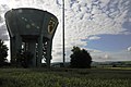
Scheppach: water tank

Unterheimbach


Division of space

According to data from the State Statistical Office , as of 2014.
history
Bretzfeld was first mentioned as Bretesfeld in 1037. During the time of the tribal duchies, the place was in the Duchy of Franconia . Until 1423 half of the place was under the monastery of Öhringen and half to the Lords of Weinsberg , who exercised the high jurisdiction . The Lichtenstern Monastery and various lower nobility had other property on site, and from the 15th century onwards, the Hohenlohe family also increasingly owned it . In 1423 Bretzfeld came to the Electoral Palatinate along with other previously Weinberg villages . After the War of the Bavarian-Palatinate Succession , Bretzfeld came to Württemberg in 1504 and was incorporated into the Oberamt Weinsberg .
Viticulture has been documented in the village since 1357 , and agriculture, fruit growing and animal husbandry also played an important role. Bretzfeld peasants under the leadership of the mayor Hans Koberer were involved in the Peasants' War in the Weinsberg bloody deed in 1525 . In the 17th and 18th centuries, Bretzfeld had a constant population of around 330. The population did not increase until the turn of the 19th century and then rose from 433 to 542 people in the period 1837 to 1939.
Due to the upheavals in the course of the Napoleonic Wars at the beginning of the 19th century, all of today's suburbs of the municipality of Bretzfeld fell to the Kingdom of Württemberg .
With the dissolution of the Oberamt Weinsberg in 1926, Bretzfeld came to the Oberamt Öhringen (from 1938: Landkreis Öhringen ). After the Second World War, the place became part of the American zone of occupation and thus belonged to the state of Württemberg-Baden , which was newly founded in 1945 and which became part of the current state of Baden-Württemberg in 1952. In the post-war years, expellees mainly from Hungary and Czechoslovakia made up almost 19 percent of the population of around 750. While many of the displaced people emigrated again and the number of inhabitants decreased by more than 100 people by 1956, the population grew again afterwards due to the influx of commuters.
The district reform of 1973 brought Bretzfeld to the Hohenlohe district. In the course of the associated reform of the community, Rappach was initially incorporated on February 1, 1972, but there were already plans for a unified community encompassing the entire Brettach Valley. First of all, from 1973, today's districts of Adolzfurt, Geddelsbach, Scheppach and Unterheimbach considered the formation of a large community of Weinfurt , but on January 1, 1975, these were combined with five other neighboring communities to form the new community of Bretzfeld. On January 1, 1977, Brettach was added, which previously belonged to the municipality of Wüstenrot. The population of the entire municipality has increased from around 8,300 in 1981 and has been over 12,000 since 2002. Currently (December 31, 2018) the community has 12,826 inhabitants.
Religions

In 1534 the Reformation was introduced in Bretzfeld, which was historically a branch church of Bitzfeld . The population remained almost purely Protestant until the Second World War. The proportion of Catholics, which was only 5.5 percent in 1939, only rose to 18 percent in 1950 with the influx of mostly Catholic expellees from Hungary and Czechoslovakia.
Today there are six Protestant parishes in Bretzfeld: Adolzfurt-Scheppach in the parish of Öhringen and the other five in the old parish of Weinsberg (until December 31, 2019) and, since January 1, 2020, the new parish of Weinsberg-Neuenstadt of the Evangelical Church in Württemberg : Bitzfeld, Bretzfeld -Rappach Schwabbach-Siebeneich, Unterheimbach and Waldbach-Dimbach.
There is also the Roman Catholic parish of St. Stephanus in Bretzfeld.
There is also an Evangelical Anabaptist Congregation , the Free Christian Congregation Philadelphia and the Christian Community Center Schwabbach, which is part of the Mülheimer Verband ( Pentecostals ).
There are also two New Apostolic parishes with church centers in Bitzfeld and Waldbach. The Jehovah's Witnesses are organizationally to Öhringen.
politics

Municipal council
In Bretzfeld, the municipal council is elected according to the procedure of the false sub-district election. The number of local councils can change due to overhang mandates . The municipal council in Bretzfeld has 26 members after the last election (2009: 25). The local elections on May 25, 2014 led to the following official final result. The municipal council consists of the elected voluntary councilors and the mayor as chairman. The mayor is entitled to vote in the municipal council.
| FWV | 48.2% | 13 seats | (2009: 46.4%, 12 seats) |
| CDU | 31.1% | 8 seats | (2009: 33.3%, 8 seats) |
| SPD / Independent | 20.7% | 5 seats | (2009: 19.9%, 5 seats) |
mayor
Thomas Föhl, FWV, was mayor of the community for three terms (24 years). On March 8, 2015, a new mayor was elected, in this election Thomas Föhl no longer stood. Martin Piott, who until then was mayor of Fichtenau in the district of Schwäbisch Hall, was elected as his successor from May 16, 2015 .
badges and flags
The blazon of the Bretzfeld coat of arms reads: In gold under a black stag pole, a red grape, from the stem of which a red vine leaf extends on both sides. The flag of the municipality is red and yellow.
The coat of arms of the new municipality of Bretzfeld, with the grape as a symbol for viticulture and the stag as a symbol for belonging to Württemberg, takes up the common features of almost all districts. The coat of arms and flag were awarded to the municipality on February 17, 1976 by the district office of Hohenlohekreis.
Community partnerships
A partnership with Budaörs , Hungary has existed since 1989 . There is a community friendship with the community of Pretzfeld in the Forchheim district ( Bavaria ).
Culture and sights

Buildings
Protestant churches
- Marienkirche Adolzfurt : In the Middle Ages, Adolzfurt was a church branch of Unterheimbach. A chapel belonging to the Lichtenstern monastery to Our Lady in Adolzfurt came to Hohenlohe-Langenburg in 1563. In 1613 a separate parish was set up in Adolzfurt. According to plans of the architect Heinrich Schickhardt and construction management of the castle Vogts of Neuenstein, Georg Kern, St. Mary's church was 1618-1621 to cross church rebuilt and expanded to the south with three-sided gallery, Mr stalls along the 5/8 choir wall and patronage gallery opposite the pulpit. The free-standing altar with its wooden top (crucifix, Mary and John; a sawing with a plastic effect) dates from 1684. The church was partially destroyed in 1945 and was rebuilt by 1953. The artist Wolf-Dieter Kohler created three choir windows in 1967 (in the tracery from left to right: creator's hand, sacrificial symbol pelican, heavenly Jerusalem. In the motif windows on the left: Annunciation to Mary, birth, presentation of Jesus in the temple; middle: Last Supper, Gethsemane, crucifixion ; right: Resurrection, Emmaus, meeting of the risen Christ with disciples and Thomas).
- The Laurentiuskirche Bitzfeld was mentioned when the place was first mentioned in 1255. The late Romanesque basement of the tower dates back to the Middle Ages and today contains the sacristy, while the east-facing Gothic choir with cross-ribbed vaults in the 15th century and the nave, extended in the Renaissance style, as a transverse church with the pulpit on the southern long side and corresponding orientation of the Stalls and the tower structure were built in 1624 by Friedrich Vischlin , the ducal church builder from Stuttgart. The baptismal font dates from 1727. Land architect Johann Adam Groß the Elder raised the nave in 1747 so that circulating galleries, some of them two-story, could be built. The gallery with the "official or gentleman's chair" was accessed from the south side with an external staircase that has since been removed. The organ gallery was built above the choir arch. In 1750, Johannes Stiegler from Prague painted the interior of the church in the style of rural baroque: the pulpit, the gallery parapets with themed images from the Old and New Testaments, the covings and the ceiling painting in the style of French bandwork. This design was whitewashed in 1860 and exposed again in 1956 during the total renovation and restoration under the architect Heinz Klatte. During the renovation in 1956, the late Renaissance pulpit from 1624 was moved from the center of the south wall to its current location (directly south of the east gallery), with the base of the pulpit and staircase removed.
- The Johanneskirche Bretzfeld goes back to a Gothic building, first mentioned in 1357 , which was rebuilt in 1723 while retaining the older tower base. The choir of the single-nave church, spanned by a cross vault, is located on the ground floor of the east tower. In the 1960s, frescoes from the middle of the 13th century were uncovered. A two-seater church chair from 1588 and apostle painting on the gallery parapet have been preserved. The passion window in the choir was created in 1960 by the Stuttgart glass painter Adolf Valentin Saile .
- The Rappach church forms the historic center of the village on a mountain spur. The church, which can be seen from far and wide, dates back to the Staufer period : at the outer corners of the nave a head with eagle wings, a lion and two grimaces as eaves consoles, the tower base made of humpback blocks typical of the time, and inside a wide, square tower choir with a Romanesque window. Shortly before 1500, the fortified church in the walled cemetery was consecrated to Our Lady, St. James and St. John (in 1499 Rappach belonged to the parish of Waldbach, with which it was reformed in 1534 by the sovereign Württemberg). In the 17th century the building was supplemented by a sacristy, the choir arch, the choir gallery and the west portal, and the tower was raised by a half-timbered floor and provided with a pyramid roof. In the choir there is a wall tabernacle with a Gothic lock; the Altarmensa is still medieval. The interior renovation from 1966/67 uncovered well-preserved frescoes (Passion and Easter story in 16 fields) from the 14th century and a later depiction of Christ. The colored glazing of a small window with a Pentecostal motif dates from the 1960s. The flat ceilings in the choir and nave are also modern. The church was probably always a branch church of Kilian's Church in Waldbach . Today it belongs to the Protestant Parish Bretzfeld-Rappach.
- The Sebastianskirche Schwabbach goes back to a chapel that already existed in the 14th century, which was rebuilt and renovated several times. The base of the tower is the oldest part of the building. The church received its present form mainly through the expansion of the nave to the south in 1655, the reconstruction in 1804 and the tower increase in 1850. The interior was renovated in 1891 by the well-known architect Heinrich Dolmetsch , with the nave in particular by the Stuttgart church painter Theodor Bauerle painted in a neo-Gothic style and provided with a Christ medallion on the choir arch, a galvanoplastic sculpture by the company WMF (Geislingen / Steige). The neo-Gothic space was removed during the thorough interior and exterior renovation in 1955, the last time the church was carefully renovated inside and outside in 2010/11.
- The church of St. Georg and Nikolaus Unterheimbach was initially a Gothic choir tower church, the nave of which had to give way to a new building in 1621 and again in 1757. This last version has survived to this day: a closed tower choir, used as a sacristy, and the so-called Markgräfler Wand , a combination of pulpit altar and organ loft as the eastern end of the church, plus a three-sided loft with Baroque parapet paintings. The 19th century organ no longer towers over the pulpit, but stands on the west gallery. The ceiling painting Ascension from 1952 in a baroque stucco frame in the nave is by Professor Rudolf Yelin the Elder. J.
- The Kilianskirche Waldbach was named after predecessor churches in wood and stone as early as 1264 as a church of the deanery Weinsberg. It was the mother church for the places Dimbach, Rappach, Scheppach, Schwabbach and Siebeneich. The choir of today's Kilian's Church is Gothic, the nave was rebuilt in 1616/18 as a transverse church . In 1748 it was increased. "Kilian's Church is a fascinating example of a living building that was shaped by the respective epochs of art and piety" and designs from early Gothic (tower choir), Gothic ( sacrament house , earlier high altar), Renaissance (church nave architecture, panels, ornaments), Baroque (nave elevation, second gallery, stucco ceiling with painting) contains "... an impressive testimony to how people in their time have valued the church space and designed it according to their beliefs".
The historic inns Rößle and Linde from the 18th century are located in the village . The building of the old town hall was also a restaurant before 1850. Behind the church there is a historic mill, in the village there are also some old Franconian courtyards and an old wine press from 1794 on the Lindelberg .
The former station building, which is listed as a historical monument, was also converted into a restaurant with hotel rooms.
Museums
In Bretzfeld there has been the Budaörser Heimatmuseum Bretzfeld since 1996 , in which expellees from the place in Hungary (a suburb of the capital Budapest) remember their former homeland.
Country type Bretzfeld
The art project Landart Bretzfeld was installed in 2012 between the Bürgerwiese in Bretzfeld, the former powder mill in Adolzfurt and the Talaue in the direction of Geddelsbach .

Egyptian pyramid, carmine red, by Hans A. Graef and the two giants by Wolfgang Steck
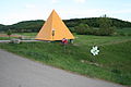
Egyptian pyramid, sun yellow, by Hans A. Graef

Flower meadow by Elfriede Schwaderer


Economy and Infrastructure
On June 30, 2013, 2,154 residents were employed in Bretzfeld within the municipal boundaries, 4,314 commute to other municipalities for this purpose, while 1,341 employees live outside of the municipality. So there is a surplus of out-commuters .
Viticulture
Bretzfeld is a wine-growing town in the Württemberg growing region . Its locations belong to the large Lindelberg site in the Württembergisch Unterland area, with the exception of the Berg site in the Brettach district, which is part of the Staufenberg site.
traffic
Street
Bretzfeld is connected to the national road network by the federal motorway 6 ( Saarbrücken - Waidhaus ). Exit 39 is in the Schwabbach district.
rail
The town is connected to the rail network by the Crailsheim – Heilbronn railway. Since December 2005 it has been operated between Heilbronn and Öhringen as a light rail based on the Karlsruhe model . In the area of the municipality, the S4 stops on the way from Karlsruhe via Heilbronn to Öhringen at the stops Scheppach, Bretzfeld and Bitzfeld. The Bretzfeld stop is also the hub of the regional bus routes.
Bretzfeld is included in the Heilbronner-Hohenloher-Haller local transport network.
Schwabbach industrial park
There are two business parks immediately at the A6 motorway exit Bretzfeld. These have developed very well in the last few decades due to their convenient location.
Educational institutions
The Bretzfeld elementary , secondary and secondary school are combined in the BZB = Bretzfeld Education Center . In addition, there are pure elementary schools in the districts of Bitzfeld, Scheppach and Unterheimbach.
In this BZB building is also the community library, which is open several times a week. Also a teaching pool, which can be used by the population several times a week free of charge.
The JEB = youth and adult education Bretzfeld offers, comparable to the adult education centers, an extensive course program.
Sons and daughters of the church
- Wilhelm Lang (1852–1912), born in Schwabbach, Oberamtmann in Württemberg
literature
- Jürgen Hermann Rauser: Brettachtaler Heimatbuch . Jahrbuch-Verlag, Weinsberg 1983 ( Hohenlohekreis local library . Volume 14)
Web links
Individual evidence
- ↑ State Statistical Office Baden-Württemberg - Population by nationality and gender on December 31, 2018 (CSV file) ( help on this ).
- ^ Hohenlohekreis: Bretzfeld: Gate to the Hohenloher Land. Online at www.hohenlohekreis.de, accessed on October 26, 2014
- ↑ Natural areas of Baden-Württemberg , State Institute for the Environment, Measurements and Nature Conservation Baden-Württemberg, Stuttgart 2009
- ^ The state of Baden-Württemberg. Official description by district and municipality. Volume IV: Stuttgart district, Franconian and East Württemberg regional associations. Kohlhammer, Stuttgart 1980, ISBN 3-17-005708-1 . Pp. 173-179
- ↑ a b c d e f g h i j k l m Federal Statistical Office (Hrsg.): Historical municipal directory for the Federal Republic of Germany. Name, border and key number changes in municipalities, counties and administrative districts from May 27, 1970 to December 31, 1982 . W. Kohlhammer, Stuttgart / Mainz 1983, ISBN 3-17-003263-1 , p. 465 ff .
- ↑ a b c d e f g h i j k l 2018 annual report of the municipality of Bretzfeld
- ^ Annual report 2011 of the municipality of Bretzfeld
- ↑ The field name Steinsfeld north of the Schwabbach still indicates the lost place Steinfurt today , see Brettachtaler Heimatbuch (1983), p. 133: The becoming of settlement and district
- ↑ a b Federal Statistical Office (ed.): Historical municipality register for the Federal Republic of Germany. Name, border and key number changes in municipalities, counties and administrative districts from May 27, 1970 to December 31, 1982 . W. Kohlhammer, Stuttgart / Mainz 1983, ISBN 3-17-003263-1 , p. 455 .
- ↑ State Statistical Office, area since 1988 according to actual use for Bretzfeld.
- ↑ Population development in the municipalities of Baden-Württemberg in 2002
- ↑ a b Website of the Evangelical Church Community Adolzfurt-Scheppach
- ^ Website of the Evangelical Church District Weinsberg-Neuenstadt
- ↑ a b Website of the Evangelical Church Community Bitzfeld
- ↑ a b c Website of the Evangelical Church Community Bretzfeld-Rappach
- ↑ a b Website of the Evangelical Church Community Schwabbach
- ↑ a b Website of the Evangelical Church Community Unterheimbach
- ↑ a b website of the Evangelical Church Community Waldbach-Dimbach
- ↑ Heinz Bardua: The district and community coats of arms in the Stuttgart administrative region . Theiss, Stuttgart 1987, ISBN 3-8062-0801-8 (district and municipality coat of arms in Baden-Württemberg, 1). P. 50
- ↑ Vita and work see [1]
- ↑ a b c d e f g Otto Friedrich: Evangelical churches in the deanery Weinsberg - picture reading book ; ed. Ev. Deanery Weinsberg, 2003
- ^ Claudia Lamprecht: Rudolf Yelin (1902-1991): catalog raisonné of the building-related works ; o. O. (Stuttgart), o. J. (1991), p. 155
- ↑ Website for the Landart Bretzfeld concept (accessed on May 6, 2012)
- ↑ Table 254-04-5 Employees subject to social security contributions at their place of work and residence as well as inbound and outbound commuters across communal boundaries by gender - reference date June 30th. - Municipalities, 08126011 Bretzfeld . Federal and state statistical offices. Retrieved October 9, 2015.
Adolzfurt | Bitzfeld | Brettach | Dimbach | Geddelsbach | Rappach | Scheppach | Schwabbach | Siebeneich | Unterheimbach | Waldbach

Bretzfeld | Dörzbach | Forchtenberg | Ingelfingen | Krautheim | Künzelsau | Copper cell | Mulfingen | Neuenstein | Niedernhall | Öhringen | Pfedelbach | Schöntal | Waldenburg | Weissbach | Doubts