Künzelsau
| coat of arms | Germany map | |
|---|---|---|
|
Coordinates: 49 ° 17 ' N , 9 ° 41' E |
|
| Basic data | ||
| State : | Baden-Württemberg | |
| Administrative region : | Stuttgart | |
| County : | Hohenlohe district | |
| Height : | 218 m above sea level NHN | |
| Area : | 75.17 km 2 | |
| Residents: | 15,391 (Dec. 31, 2018) | |
| Population density : | 205 inhabitants per km 2 | |
| Postal code : | 74653 | |
| Primaries : | 07940, 07905, 07944 | |
| License plate : | KÜN, EAR | |
| Community key : | 08 1 26 046 | |
| LOCODE : | DE KUE | |
| City structure: | Core city and 10 districts | |
City administration address : |
Stuttgarter Strasse 7 74653 Künzelsau |
|
| Website : | ||
| Mayor : | Stefan Neumann | |
| Location of the city of Künzelsau in the Hohenlohe district | ||
Künzelsau (high German pronunciation: [kʏnt͡sl̩sˌʔaʊ̯] , in the local, to the East Frankish counting dialect: Kinzlsâ / [ kʰinʦlsˌə ], even briefly Kiau / [ kiau ], according to a written language shortening Kü-au ) is the county seat of Hohenlohe in Frankish coined the northeast Baden-Württemberg . It is a medium-sized center in the Heilbronn-Franken region .
geography
Geographical location
The city of Künzelsau is located at 210 to 435 m above sea level on the lower Kocher , a right tributary of the Neckar , about 40 km east of Heilbronn . After Öhringen, the city is the second largest city in the Hohenlohe district and its district town .
District seat / district town
The Hohenlohekreis was formed on January 1st, 1973 by merging the old districts of Künzelsau (KÜN) and Öhringen (ÖHR). The city of Künzelsau kept the district seat and the license plate was KÜN, as before for the old district. By district council resolution of November 3, 2014, the old ÖHR license plate was re-registered. The city is one of the seven centers of the Heilbronn-Franken region within the administrative district of Stuttgart .
City structure
Before the municipal reform in the 1970s, which greatly expanded the city limits, only the city of Künzelsau, the villages of Garnberg and Nagelsberg and the residential areas Gaisbacher Rank and Hofratsmühle belonged to Künzelsau .
Today Künzelsau consists of 11 districts. The core city lies in the valley ( 218 m ) of the Kocher, which is dug deep into the Hohenlohe plain , the old town part stands on the left bank of the river in a southern wedge of the valley in front of the inlet of the Künsbach from the southeast; younger parts of the city center fill this wedge or pull up half of the northern opposite slope in rows of settlements.
From an administrative point of view, the very large Taläcker residential area, which is partly built with multi-storey houses, is also part of the core city . It lies southwest on the flat shoulder of the slope above the valley widening. This new development was built in the early 1990s as part of the country's housing program. It is connected by a funicular with the city center, which is about 180 m below.
About two and a half kilometers south of the city center is the district of Gaisbach ( 381 m ) on the plateau, surrounded by its hamlets Haag, Kemmeten and Weckhof and the Schnaihof farmstead. The hamlet of Etzlinsweiler, which also belongs to it, is located further east across the Künsbach cut.
The core city in its small basin almost borders the western city limits. To the east of the Kocher upstream there are the districts of Morsbach ( 223 m ) and Kocherstetten ( 254 m ) with the hamlet of Stetten Castle (over 330 m ) on a side spur and the Bienenhof farms on the right plateau and Buchenmühle in the valley.
Downstream of the Kocher town center, Nagelsberg ( 312 m ) sits on the lower and middle mouth of the right side stream Deubach , to the north in its lower valley lies Belsenberg ( 256 m ). The Rodachshof and Siegelhof settlements on the heights belong to it.
On the upper edge of the river valley in the north stands Garnberg ( 404 m ), set back a little in the flat upper Deubach-Mulde Amrichshausen ( 401 m ); the districts of Steinbach ( 412 m ) (with the hamlets of Büttelbronn, Ohrbach ( 430 m ) and Wolfsölden), Nitzenhausen ( 431 m ) (with the hamlets of Berndshausen and Sonnhofen) and Laßbach (with the villages of Mäusdorf and Vogelsberg and the farms of Falkenhof, Kügelhof and Rappoldsweiler Hof) ( 435 m ) are almost all further away to the right of the Kocher valley on the plateau.
In the urban area of Künzelsau are the abandoned villages (each assigned to the former communities) Neugreut zu Amrichshausen, a chapel to the Holy Cross in Belsenberg, Hefenhofen, Herborten, Steinbach, Gackstatt and Schupperg zu Gaisbach, Baldehofen, Kronhofen, Webern, Wartturm, the abandoned Zarge Castle zu Künzelsau, Alosweiler, Bole or Bohel, Hitels (merged into Vogelsberg), Schätzlinshof and Schlothof zu Laßbach, the so-called Heidenschlößchen zu Morsbach as well as Holderbach, Dörrenhof, Klingen and Wilhelmshaus zu Steinbach.
The district area including all parts of the city covers 75.17 km².
Division of space

According to data from the State Statistical Office , as of 2014.
history
middle Ages
Künzelsau was first mentioned in a document in 1098. The place is located on the Künsbach in the Talaue , in the Conzles-Aue . The place name goes back to the German first name Konrad or its "nickname Cunzilo" . Accordingly, the place was created on the floodplain of the Konz . The place is also known as " Hohenlohe Little Nuremberg".
Modern times
Until 1802, the city was under a Ganerbegemeinschaft , which consisted of a changing number of members. In 1806 Künzelsau and the Principality of Hohenlohe became part of the Kingdom of Württemberg . In 1811, Künzelsau became the seat of the Oberamt of the same name (since 1938: Künzelsau district ).
The Künzelsau train station was inaugurated in 1892 when the Kochertal Railway was connected to the Württemberg railway network .
With the district reform, the former district town of the Künzelsau district became the district seat of the new Hohenlohe district in 1973, which includes the old district of Öhringen and a small part of the old district of Buchen .
Religions
The Reformation was introduced in Künzelsau in 1556. The city is therefore predominantly evangelical. Since 1824/25 it has been the seat of the dean's office of the Evangelical Church in Württemberg, which was moved here from Ingelfingen (see Künzelsau church district ). There are Protestant parishes in Belsenberg, Kocherstetten, Künzelsau and Morsbach. Most of the Protestants from other parts of the city belong to them. Only the Protestants from the districts of Berndshausen, Nitzenhausen and Wolfsölden belong to the Buchenbach parish (Mulfingen parish).
The formerly independent Catholic parishes of Künzelsau, Nagelsberg, Kupferzell and Amrichshausen are combined to form the Künzelsau pastoral care unit and part of the Hohenlohe deanery in the Rottenburg-Stuttgart diocese .
In addition to the two large churches, there is a New Apostolic congregation in Künzelsau (with churches in Künzelsau and Gaisbach), a congregation of Jehovah's Witnesses (Kingdom Hall in Gaisbach), a Greek Orthodox congregation , the Pentecostal-Charismatic mission congregation of determined Christians from the Bund Freikirchlicher Pentecostal congregations and others represent Christian denominations.
After the mention of Jews in the 14th century, the existence of a synagogue in Scharfengasse and a cemetery in Gewann Holderrain, as recorded by the chronicler Augustin Faust, the Jews were expelled in 1580/81. A modern Jewish community in Künzelsau did not emerge until the late 19th century, in particular through the influx of Jews from Nagelsberg . The Israelite community was initially called Nagelsberg-Künzelsau, then Künzelsau-Nagelsberg and finally Künzelsau from 1900, which is how the name documents the hike from Nagelsberg to Künzelsau. The Künzelsau synagogue was inaugurated in 1907 and was destroyed in the November pogrom in 1938 . The community died out in the course of the persecution of the Jews at the time of National Socialism. Some community members were able to emigrate, but the majority perished in the course of the deportation of German Jews . Only the wholesale merchant Sigbert Baer survived the time of the Third Reich in Künzelsau.
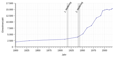
Population development
|
|
Incorporations
- April 1, 1912: Garnberg
- October 1, 1937: Nagelsberg
- January 1, 1972: Amrichshausen, Belsenberg, Kocherstetten, Laßbach, Nitzenhausen and Steinbach
- April 1, 1972: Gaisbach
- January 1, 1973: Morsbach
- January 1, 1977: Sonnhofen (reclassification from Mulfingen)
politics
Municipal council
The municipal council in Künzelsau has 22 members (up to 2009: 26). The local election on May 26, 2019 led to the following official final result. The municipal council consists of the elected voluntary councilors and the mayor as chairman. The mayor is entitled to vote in the municipal council.
| Parties and constituencies | % 2019 |
Seats 2019 |
% 2014 |
Seats 2014 |
% 2009 |
Seats 2009 |
|
|---|---|---|---|---|---|---|---|
| CDU | Christian Democratic Union of Germany | 29.0 | 6th | 35.2 | 7th | 35.4 | 9 |
| SPD / Greens | Social Democratic Party of Germany / Alliance 90 / The Greens * | 22.9 | 5 | 22.5 | 5 | 23.0 | 6th |
| UBK | Independent citizens of Künzelsau | 18.4 | 4th | 16.7 | 4th | 7.7 | 2 |
| FfK | Group for Künzelsau | 17.2 | 4th | 13.7 | 3 | 19.3 | 5 |
| Free | The free | 12.6 | 3 | 11.8 | 3 | 14.6 | 4th |
| total | 100 | 22nd | 100 | 22nd | 100 | 26th | |
| voter turnout | 53.4% | 48.5% | 50.5% | ||||
* 2014 only SPD
mayor
The mayor is directly elected for eight years . Stefan Neumann won the 2010 election. On September 1, 2010, he replaced Volker Lenz, who had been in office since 1986.
See also: List of Mayors of the City of Künzelsau
badges and flags
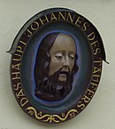
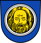
The blazon of the Künzelsau coat of arms reads: The bearded golden head of John the Baptist in blue on a silver bowl. The city flag is blue and white.
The severed head of John the Baptist , the Künzelsau church patron, appears on the seals of Künzelsau as early as 1525 . The colors of the coat of arms were probably not determined until the 18th or 19th century.
Town twinning
Künzelsau has had partnership relationships with the city of Marcali in Hungary since 1992 .
Economy and Infrastructure
traffic
Road traffic
The most important traffic artery of Künzelsau is the federal road 19 , which comes from Bad Mergentheim in the north . In the Künzelsau district of Nagelsberg , it reaches the Kocher Valley, crosses Künzelsau and leaves the valley again via a three-lane path. It then leads south via Künzelsau-Gaisbach towards Schwäbisch Hall and Gaildorf .
In the southern neighboring municipality of Kupferzell , the B 19 has a connection to the federal motorway 6 to Heilbronn in the west and Nuremberg in the east.
Künzelsau is connected to the towns in the Kocher Valley and the surrounding plateaus by state and district roads.
Air traffic
The Schwäbisch Hall-Hessental airfield operated by the Würth Group is also located near Schwäbisch Hall .
railroad
Künzelsau is currently no longer connected to the railway network. The city was connected to the rail network in 1892 when the Royal Württemberg State Railways opened the so-called Kochertalbahn from Waldenburg to Künzelsau, and Haag also received a station with a type I standard station as a reception building. The extension of the railway to Forchtenberg in 1924 provided Nagelsberg with a railway connection. In 1981, passenger transport was discontinued in favor of the Hohenlohekreis local transport model , followed by total closure in 1991. A large part of the previous railway line has been converted into an asphalt cycle path that leads up to the Hohenlohe plain . In 2008, the reopening of the section between Künzelsau and Waldenburg was investigated as part of the Heilbronn urban railway , but the district council announced in 2012 that the project would not be pursued further due to excessive investment costs and "lack of positive economic prognosis". A new test as part of a state program for reactivation should take place.
Funicular
Since 1999, the Künzelsau funicular has been connecting the residential construction area Taläcker on the Hohenlohe level with the core town in the Kocher valley.
Local businesses
Tanneries and shoe factories already existed in the 19th century. In 1925 Wilhelm Veigel developed double controls for driving school cars. In 1937, Luise Hermann began to produce workwear due to economic hardship. In 1948 the L. Hermann clothes factory (today: Mustang-Bekleidungswerke GmbH. + Co. KG ) produced the first jeans in Germany . With resettled and newly founded companies, the industrial development of Künzelsau took off from 1944/45 onwards. The Künzelsau area has the greatest concentration of world market leaders in Germany.
Künzelsau is the seat of several globally operating companies in the sectors of assembly parts (trading companies), ventilation technology, conveying technology, explosion protection and textiles (jeans).
- Würth Group , assembly technology
- Berner SE , consumables and tools for industry and craft
- Mustang-Bekleidungswerke GmbH + Co. KG
- P + V GmbH , Precision and Connection Technology
- STAHL CraneSystems GmbH , conveyor technology
- Ziehl-Abegg SE , electrical engineering
- Rosenberg Ventilatoren GmbH, air conditioning / ventilation technology
The Sparkasse Hohenlohekreis has its seat in Künzelsau, the Volksbank Hohenlohe operates a main office here. Other national banks also have branches in Künzelsau.
The city of Künzelsau is involved in the Hohenlohe industrial park on the markings of Kupferzell and Waldenburg.
Viticulture
In Künzelsau there is a small amount of viticulture . The sites belong to the large Kocherberg site in the Jagst-Kocher-Tauber area. The district of Belsenberg has its own individual location with the Heilig Kreuz location.
Courts and bodies
Künzelsau has local court that the District Court of Heilbronn and the Court of Appeal sbezirk Stuttgart belongs.
The city is the seat of the Künzelsau church district of the Evangelical Church in Württemberg and the Hohenlohe deanery of the Rottenburg-Stuttgart diocese .
The Künzelsau volunteer fire brigade is also the base fire brigade for the neighboring communities of Ingelfingen, Kupferzell, Mulfingen, Niedernhall and Weißbach as well as for the Hohenlohe industrial park in Waldenburg. She appears here in large fires and offers heavy technical assistance. In addition, it provides special services for the entire Hohenlohe district.
Educational institutions
Before the gates of Künzelsau, in the district of Hofratsmühle, there has been a branch of the Heilbronn University since 1988 with the courses in electrical engineering , industrial engineering , business administration and media, product, customer management, business administration, sports, culture and leisure management and since the winter semester 2007 / 2008 energy management . In 2005 the University of Applied Sciences was renamed the Reinhold-Würth University of Heilbronn University in Künzelsau. A little over 1,500 students attended the university in the 2015/16 winter semester.
The city of Künzelsau is responsible for the Künzelsau elementary and technical secondary school , the four elementary schools in the districts of Amrichshausen, Gaisbach (Reinhold-Würth-Schule), Kocherstetten and Taläcker, the Georg Wagner -realschule, the Brothers Grimm School ( special needs school ) and the Ganerbe high school . The Hohenlohekreis is responsible for the Geschwister-Scholl School (school for the mentally handicapped), the Erich-Kästner School (school for the speech-impaired) and the three vocational schools : vocational school, business school and home economics school ( Karoline-Breitinger school).
The state of Baden-Württemberg is the sponsor of the Schlossgymnasium, an advanced high school with boarding school . There is also an adult education center and a youth music school.
In the 2006/2007 school year, the Würth Group opened a private school called Freie Schule Anne-Sophie (named after a daughter of Bettina Würth who died as a child ). Pupils in grades one to eight are taught all-day, with an extension to grade ten planned. In the Taläcker district the company moved into its own school building for the 2008/2009 school year.
Sports and leisure facilities
The only river swimming pool in Baden-Württemberg is located at the Kocher. The sports facilities "Im Prübling" offer the sports stadium, a tennis court, tennis courts and tennis hall. Football pitches are also in different suburbs. On the south-western ridge above Künzelsau - near the Taläcker residential area - there is a training and forest nature trail.
Culture and sights
Museums
The Würth Museum in the Gaisbach district and the Hirschwirtscheuer in the city center are dedicated to contemporary art. The Hohenloher Kunstverein has also been operating an art gallery on Kocherbrücke since November 2008. In 2007, to mark the company's 75th anniversary, a museum for the future of Mustang-Bekleidungswerke GmbH & Co. KG was opened in the founder's house. Since July 2010 the city museum in the Schnurgasse - right next to the Hirschwirtscheuer - can be visited.
Buildings
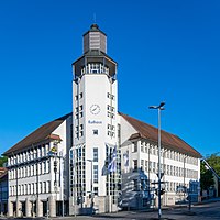
The old town hall from the 16th century was built above the Künsbach.
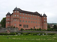
The writer Hermann Lenz grew up in the building at Keltergasse 63 , which was erected as a rectory in 1711 . Other sights include the Johanneskirche , built in 1617, and Bartenau Castle, built in 1679 . In the Nagelsberg district, on the edge of the mountain at 245 m, there is the Zarge castle ruins and on the other side of the Deubach valley the Nagelsberg castle with the adjoining village. Opposite both, on the other side of the Kochertal , is the Kocherstein castle ruin in Ingelfingen .
The Wartberg Tower on the 372.5 m above sea level southeast of Künzelsau . NHN high Wartberg is a 10 m high former watchtower built in 1488 . An outside staircase leads to the approximately 3.5 m high entrance.
Youth facilities
The youth culture association Kokolores is located in the old train station. The city maintains a youth center, which is located near the fire station, as well as a youth block house in the Taläcker district.
Personalities
Literature (selection)
- Description of the Oberamt Künzelsau . Stuttgart: W. Kohlhammer, 1883. (Reprint: Magstadt: Horst Bissinger, 1969)
- Georg Himmelträger : The art monuments of the former Oberamt Künzelsau . Stuttgart: Deutsche Verlags-Anstalt, undated [1962]. [Reprint:] Frankfurt / Main: Weidlich, 1983
- Stefan Kraut: Back then in Künzelsau. Views of days gone by . Horb aN: Geiger, 1991
- Werner Nowak: The Künzelsau inheritance. Business Organization and meaning . Plochingen a. N .: Schorndorfer, undated [1966]
- Jürgen Hermann Rauser: Künzelsauer Heimatbuch . First book: Stadtgeschichte, Künzelsau 1981. Second book: Dörfergeschichte, Künzelsau 1984
Individual evidence
- ↑ State Statistical Office Baden-Württemberg - Population by nationality and gender on December 31, 2018 (CSV file) ( help on this ).
-
^ LEO-BW Taläcker - Baden-Württemberg State Archive. Accessed on June 17, 2012.
City of Künzelsau: Taläcker. Accessed on June 17, 2012. -
↑ Sources for the city structure:
- The state of Baden-Württemberg. Official description by district and municipality. Volume IV: Stuttgart district, Franconian and East Württemberg regional associations. Kohlhammer, Stuttgart 1980, ISBN 3-17-005708-1 . Pp. 193-201
- Künzelsau . In: The Hohenlohe district . Edited by the Baden-Württemberg State Archive in conjunction with the Hohenlohe district. Thorbecke, Ostfildern 2006 (Baden-Württemberg - The state in its circles), ISBN 3-7995-1367-1 . Volume 2. pp. 3-53
- Main statutes of the city of Künzelsau (PDF) §13 districts
- ↑ State Statistical Office, area since 1988 according to actual use for Künzelsau.
- ^ A b c d Rudolf hose: Hohenlohe Franconia: landscape, history, culture, art , Glock and Lutz, Nuremberg 1964 p. 369.
- ↑ Memorial sites for the victims of National Socialism. A documentation . Volume 1. Federal Agency for Civic Education, Bonn 1995, ISBN 3-89331-208-0 . P. 53f.
- ^ Federal Statistical Office (ed.): Historical municipality directory for the Federal Republic of Germany. Name, border and key number changes in municipalities, counties and administrative districts from May 27, 1970 to December 31, 1982 . W. Kohlhammer, Stuttgart / Mainz 1983, ISBN 3-17-003263-1 , p. 451 .
- ↑ a b Federal Statistical Office (ed.): Historical municipality register for the Federal Republic of Germany. Name, border and key number changes in municipalities, counties and administrative districts from May 27, 1970 to December 31, 1982 . W. Kohlhammer, Stuttgart / Mainz 1983, ISBN 3-17-003263-1 , p. 452 .
- ^ Federal Statistical Office (ed.): Historical municipality directory for the Federal Republic of Germany. Name, border and key number changes in municipalities, counties and administrative districts from May 27, 1970 to December 31, 1982 . W. Kohlhammer, Stuttgart / Mainz 1983, ISBN 3-17-003263-1 , p. 467 .
- ↑ Heinz Bardua: The district and community coats of arms in the Stuttgart administrative region . Theiss, Stuttgart 1987, ISBN 3-8062-0801-8 (district and municipality coat of arms in Baden-Württemberg, 1). P. 89
- ^ Rainer Stein: The Württemberg standard station on branch lines . In: Eisenbahn-Journal Württemberg-Report . tape 1 , no. V / 96 . Merker, Fürstenfeldbruck 1996, ISBN 3-922404-96-0 , p. 80-83 .
-
↑ Matthias Stolla: The train hasn't left yet . In: Hohenloher Zeitung . November 27, 2008 ( from Stimme.de [accessed on January 18, 2009]). Hagen Stegmüller: Municipalities fear costs . In: Hohenloher Zeitung . December 20, 2008 ( from Stimme.de [accessed on January 18, 2009]).
- ↑ Description of the Oberamt Künzelsau, Stuttgart 1883, p. 273
- ↑ Company chronicle = archived copy ( memento of the original from March 4, 2016 in the Internet Archive ) Info: The archive link was inserted automatically and has not yet been checked. Please check the original and archive link according to the instructions and then remove this notice. - Retrieved October 12, 2015.
- ↑ Thomas Zimmermann: "Economic power spreads self-confidence" . In: Hohenloher Zeitung . September 26, 2015 (exhibition in the city museum).
- ↑ Students at universities winter semester 2015/2016 (PDF, 3 MByte), page 85, at www.destatis.de.
- ↑ Barbara Griesinger: A combative doctor goes well with school . In: Hohenloher Zeitung . September 13, 2008 ( from Stimme.de [accessed February 15, 2011]).
- ↑ Frank Stocker: The queen of screws . In: The world . July 9, 2006 ( from welt.de [accessed February 15, 2011]).
- ↑ Henry Doll: "You are the greatest treasure" . In: Hohenloher Zeitung . September 9, 2008 ( from Stimme.de [accessed February 15, 2011]).
- ↑ Hagen Stegmüller: "A great day for our club" . In: Hohenloher Zeitung . November 12, 2008 ( from Stimme.de [accessed February 15, 2011]).
- ↑ Matthias Stolla: Ideas will last until 2032 . In: Hohenloher Zeitung . July 21, 2010 ( from Stimme.de [accessed on February 15, 2011]).
- ↑ Judith Breuer : A former patrician house is now the city museum of Künzelsau. On the restoration and modernization of the Schnurgasse 10 building. In: Denkmalpflege in Baden-Württemberg , 40th year 2011, issue 2, pp. 113–117 ( PDF ( Memento of the original from 23 September 2015 in the Internet Archive ) Info: The archive link was automatically inserted and not yet checked. Please check the original and archive link according to the instructions and then remove this note. )
- ^ Rudolf hose: Hohenlohe Franken: landscape, history, culture, art , Glock and Lutz, Nuremberg 1964 p. 459.
- ↑ Map services of the Federal Agency for Nature Conservation ( information )
- ↑ Wartbergturm Künzelsau on warttuerme.de
Web links
- Official website of the city of Künzelsau
- Link catalog on the topic of Künzelsau at curlie.org (formerly DMOZ )


