Amrichshausen
|
Amrichshausen
City of Künzelsau
|
|
|---|---|
| Coordinates: 49 ° 16'56 " N , 9 ° 44'27" E | |
| Height : | 401 m above sea level NN |
| Residents : | 565 (December 31, 2011) |
| Incorporation : | January 1, 1972 |
| Postal code : | 74653 |
| Area code : | 07940 |
|
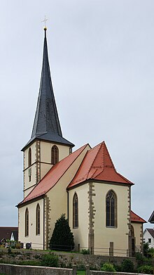
Amrichshausen in June 2010
|
|
Amrichshausen is a district of Künzelsau , the district town of the Hohenlohe district in Baden-Württemberg .
geography
Amrichshausen is located about four kilometers east of the town center of Künzelsau on the Hohenlohe plain , at an altitude of 401 m above sea level. NN , only about 750 meters from the upper right edge of the Kocher valley above the valley village of Morsbach in the south-southwest. The village occupies the shallow basin of the often dry Deubach , which runs parallel to the river here and continues to flow towards it. North to northeast of the village, at a distance of about one kilometer, there are some tiny to small forest islands already behind the marking boundary, otherwise the plateau around the village is open and, if not already built over, is mostly plowed.
Other neighboring towns are the village of Garnberg in the west, the village of Steinbach in the north- northwest , the hamlet earsbach in the north, the hamlet of Berndshausen in the north-east, the Kügelhof in the east and the village of Mäusdorf behind it .
The main connection of the village to the regional traffic is the L 1033, which reaches the plateau from the west via a long path from the town center of Künzelsau, touches its settlement area in the south and then runs further east to Mäusdorf. A district road branches off from it and runs through the village, which forks directly behind it into the K 2303 running northeast to Berndshausen and the K 2302 running north to Ohrbach.
history
The village was once called Amelungshausen, it was Würzburg since 1406, then from 1802 to 1806 Hohenlohe. Between 1500 and 1806 it was part of the Franconian Empire . In 1806 Württemberg was taken over. From 1818 to 1960, a church area administration, the Landkapitel Amrichshausen , looked after all the Catholic parishes in the entire district.
The Catholic parish church is striking with its pointed tower and its gold-plated top, visible far above the Hohenlohe plain. In the building of the Zollhaus parcel near Kügelhof was a Würzburg customs station - a memento from a time when the wider area was still divided into several gentlemen.
On January 1, 1972, Amrichshausen was incorporated into the district town of Künzelsau.
The formerly almost exclusively rural community offers numerous jobs in the companies located there in the Lerchenhöhe Craftsman Park , which is adjacent to the settlement area in the west.
Amrichshausen has 565 inhabitants (as of December 31, 2011).
Religions
The majority of the inhabitants belong to the Roman Catholic faith.
Attractions
Parish Church of the Birth of Mary
The parish church of the Birth of Mary was built between 1614 and 1625 by Julius Echter .
The church has a west tower with a square hall and choir, a ribbed vault in the style of Julius Echter , late baroque furnishings and a high altar .
The figures in the church come from the artist A. Sommer (around 1754).
Its valuable altar cross in bronze , created around 1130 and thus the third oldest in Baden-Württemberg, is one of the most impressive works of small sculptures of the 12th century. The crucifix is no longer in the parish church, but is in the diocesan museum at the bishopric of Rottenburg am Neckar . The church now adorns a replica.
Immenloch sinkhole
North of Amrichshausen is the sinkhole Immenloch ( 49 ° 17 '18 " N , 9 ° 44' 19" O ). The natural monument is m with a diameter of 35 m and a depth of 9 one of the largest of the sinkholes Hohenlohekreis.
Wayside shrine
See: wayside shrine with Pietà and wayside cross
societies
- Amrichshausen volunteer fire department
- church choir
- SC Amrichshausen - football, the SCA has played in the district league A3 Hohenlohe since its promotion in 2016
- Wander- und Kegelfreunde Amrichshausen eV - organizer of the annual High Chaparral
- Landfrauenverein Amrichshausen, board: Gertrud Rössler and Cornelia Burkert
- Hut friends Amrichshausen
- Frech-DAX Amrichshausen - Honda Dax Club - organizes a DAX meeting every year
education
- Amrichshausen Kindergarten
- Amrichshausen primary school
literature
- Jürgen Hermann Rauser: Künzelsauer Heimatbuch . Second book: village history. Künzelsau 1984
Individual evidence
- ↑ Height as shown on the map, bracketed under place name on the Geoportal Baden-Württemberg ( information ).
- ^ Federal Statistical Office (ed.): Historical municipality directory for the Federal Republic of Germany. Name, border and key number changes in municipalities, counties and administrative districts from May 27, 1970 to December 31, 1982 . W. Kohlhammer, Stuttgart / Mainz 1983, ISBN 3-17-003263-1 , p. 451 .
- ↑ Commercial building sites for Künzelsau . Website of the city of Künzelsau. Retrieved May 30, 2012.
- ^ Geotopes profile. (PDF) Freiburg Regional Council, accessed on December 29, 2015 .


