
Niedernhall
| coat of arms | Germany map | |
|---|---|---|

|
Coordinates: 49 ° 18 ' N , 9 ° 37' E |
|
| Basic data | ||
| State : | Baden-Württemberg | |
| Administrative region : | Stuttgart | |
| County : | Hohenlohe district | |
| Local government association: | Middle Kocher Valley | |
| Height : | 202 m above sea level NHN | |
| Area : | 17.71 km 2 | |
| Residents: | 4106 (December 31, 2018) | |
| Population density : | 232 inhabitants per km 2 | |
| Postal code : | 74676 | |
| Area code : | 07940 | |
| License plate : | KÜN, EAR | |
| Community key : | 08 1 26 060 | |
| LOCODE : | DE BNI | |
City administration address : |
Hauptstrasse 30 74676 Niedernhall |
|
| Website : | ||
| Mayor : | Achim Beck | |
| Location of the city of Niedernhall in the Hohenlohe district | ||
  |
||

Niedernhall is a town in the Hohenlohe district in the Franconian north-east of Baden-Württemberg . It belongs to the Heilbronn-Franconia region (until May 20, 2003 Franconia region ).
geography
Geographical location
Niedernhall lies on the bank of the middle Kocher at an altitude of 200 to 400 meters. The cooker cut deeply into the Hohenlohe plain .
The old town of Niedernhall is located at the confluence of the trout stream coming from the southeast into the Kocher, in an approximately 300 m wide floodplain of the river valley. The old town plan is a slightly warped square with a side length of a little over 200 m, one side of which almost borders the bank of the river, which here briefly moves south.
In the valley there are younger urban areas, mostly in the form of rows of settlements, which extend into the lower Forellenbachtal and along the downward left foot of the Kocherhang, or line the foot of the right valley slope or half climb it.
About one kilometer north of the old town, there is a large industrial area on the broad, right-hand valley level on the city limits of Ingelfingen . Another half a kilometer north of it, above the Kochertal valley with a view of the valley level, is the Sattelhof, the northern tip of the urban area, which nowhere extends significantly beyond the upper slope edge to the right of the valley.
The majority of the city area is on the plateau to the left above the Kocher valley between the two southeastern tributaries of the Kocher Forellenbach and, further down, Kupfer . The largest and youngest new development area is located here, just above a pavement that climbs the ridge between the Forellenbach and lower Kocher valleys. Further south-west or south of this, only the very small settlement areas Giebelhöfe and Hermersberg or Waldzimmer are located on the plateau . The southern and western edges of the urban area are mostly forested over a kilometer wide.
City structure
Niedernhall consists of Niedernhall itself, the hamlets of Giebelhöfe and Hermersberg and the Sattelhof and Waldzimmer residential areas.

Desolation
In the district of the city of Niedernhall there are some abandoned settlement areas , of which today mostly only the names in trade names or street names can be found. Information usually according to the description of the Oberamt Künzelsau about Niedernhall and according to today's maps. Position coordinates are to be understood roughly.
Map with all coordinates of this section: OSM![]()
- Bechberg , located on the right above the last of the lower copper valleys in the forest near the boundaries of Forchtenberg and Weißbach near its Guthof settlement, the mountain of a Becco. The right slope of the valley is called today (2013) Bächberg , on the so-called Kammerberg to the southeast and south opposite are still today (1883) the traces of the associated arable field and former gardens and vineyards. ( Location of the Bächberg )
- Braunsberg , old Brungesberg , the mountain of a Bruning, was located in today's Weinbergsgewann of the same name on the right southern slope of the Forellenbachtal, which flows into the Kochertalaue a little east of Niedernhall . ( Location of the Braunsberg )
- Frauenzimmern , a little over half a kilometer north of Waldzimmer in the forest between Zimmererschlag and Zinkenberg , actually rooms near the Liebfrauenkapelle. Former hamlet with this pilgrimage chapel. ( Location of women’s rooms )
- Hefenhaus , a branch that only emerged in the 19th century, is a detached house on the plateau south of Niedernhall, named after a pottery that operated there at the time (in the local dialect: Häfnerei).
- Ruwenthal (perhaps from rest, regret = lament) according to a deed of sale from 1286 in valle supra inferius Halle , i.e. above Niedernhall near the Criesbach marker border, was a hamlet with a chapel dedicated to the Three Kings and a mill, but was already at the end of the 15th century desolate. It seems that the chapel with the estates was called Zum Ruwenthal , the hamlet below it was called Thalheim , see below. ( Location of Ruwenthal )
- Schellenberg (perhaps from Schelch , the buck deer, or from schel , stallion), the mouth of the Zimmerbach brook, which flows west into the Kupfer, beyond Hermersberg to Altneufels, located in the dense forest, must have disappeared before 1579. ( Summit of the Schellenberg )
- Thalheim , a farm near Roßwasen towards Criesbach.
Division of space

According to data from the State Statistical Office , as of 2014.
history
middle Ages
Niedernhall owes its name to a salt spring . In 1037 the place was first mentioned as hala inferiori in the Öhringer foundation letter. In it, Bishop Gebhard III bequeathed . from Regensburg among other things goods in Niedernhall to the monastery Öhringen . During the time of the tribal duchies , the place was in the Duchy of Franconia . In the late 11th century, the von Stein gentlemen were wealthy in Niedernhall. After they died out, some of their property came to the Comburg monastery , to the Lords of Belsenberg, von Nagelsberg and von Neuenstein and the Lords of Dürn . The Dürner goods and rights in Niedernhall came to the Schöntal monastery in the late 13th century , which also acquired other goods and rights in the village from the lords of Neudenau, Flügelau and Bachenstein . Simultaneously with the growing holdings of the Schöntal monastery, the influence of the Hohenlohe family also increased on the spot, as the Lords of Hohenlohe were bailiffs of the Öhringer monastery and they therefore had administrative rights in Niedernhall. The Hohenlohe offices of Forchtenberg and Ingelfingen included the Niedernhall mark. In 1317, the Hohenlohe family in Niedernhall was first documented. In 1323 Hohenlohe was the sole owner of Niedernhall estates previously administered by a community of heirs from various noble families. Due to the growing holdings of the Hohenlohe family, the Schöntal Monastery sold most of its local property in 1326 to the Archbishop of Mainz , Matthias von Buchegg .

Emperor Karl IV made Niedernhall a city with Frankfurt rights in 1356 . About two thirds of the rights and duties at the site were given to the Archdiocese of Mainz and one third to Hohenlohe. The city wall that still exists today was built jointly by Hohenlohe and Kurmainz in 1362/63 in compliance with proportional representation. Because of the two rulers, there were also two mayors , which led to frequent disagreements, especially after the religious split at the time of the Reformation, and prevented any economic upturn.
Modern times
In 1799, the Hohenlohe-Ingelfingen line acquired the Mainz part of the city, which, however, did not result in a uniform administration, as the old Hohenlohe property lay with the Hohenlohe-Öhringen line.
In the course of the Reichsdeputationshauptschluss , Niedernhall, like most of the Hohenlohe areas, became part of the Kingdom of Württemberg . The place became an independent municipality and was initially subordinated to the Neuenstein District Office, then to the Schöntal District Office in 1810 and to the Künzelsau District Office in 1811 . The city had 1,562 inhabitants in 1812. In 1945, Niedernhall became part of the American zone of occupation and thus belonged to the newly founded state of Württemberg-Baden , which was incorporated into the current state of Baden-Württemberg in 1952. In 1973 the district reform took place in Baden-Württemberg , when the city came from the Künzelsau district to the Hohenlohe district .
Salt extraction
The Niedernhaller Saline developed since 1483, but suffered from a lack of firewood as early as 1579 and stood still in 1588. With the introduction of a new evaporation technique ( graduation houses ) from 1592 it recovered again. However portrays a source from the year 1607 the forest on the Hermersberg still in bad shape as a result of overexploitation in conjunction with over-aged coppice stocks: "(If) of such shape vortfahren and Khein other order and Behegung the Höltzer will wreak on the forest corridor, the same in a few years it has to be utterly corrupted and turned into nothing but slouching and lying. "
The salt works remained in operation until the beginning of the 19th century. Because the salt content of the extracted brine had fallen and the Württemberg rock salt was driving down prices, it was then closed. Head of the saline was u. a. Carl Christian Friedrich Glenck .
politics


mayor
In the mayoral election on May 5, 2014, Achim Beck (independent) defeated his competitors Marion Hannig-Dümmler, Karl-Heinz Ehrmann and Uwe Burkhardt-Götzelmann with 79.6 percent of the valid votes cast, with a turnout of 65.5 percent elected for his first term.
List of mayors / mayors
Since Niedernhall had several sovereigns for centuries, Kurmainz and Hohenlohe, there were mostly several mayors .
Mayor of Mainz
| Term of office from | to | comment | |
|---|---|---|---|
| Christoph Bezold | 1559 | 1576 | |
| Paulus Holtzschuher | 1576 | 1601 | |
| Elias Knapp | 1601 | 1609 | |
| Veit Gerich | 1609 | 1618 | |
| Elias Bayer | 1618 | 1632 | deposed because Hohenlohe is sole ruler |
Württemberg mayor after 1809
| Term of office from | to | comment | |
|---|---|---|---|
| Leonhard Friedrich Stolzenberg | 1809 | 1830 | |
| brown | 1831 | 1853 | |
| Friedrich Schmidt | 1853 | 1889 | |
| Foss | 1889 | 1905 | |
| Richard Hohrein, Schramberg | 1906 | 1922 | Only confirmed in the second choice, as too much "free wine" should have flowed in the first choice |
| Ernst Lutz, Waldbach near Weinsberg | 1922 | 1928 | |
| Hans Schon, Oberndorf / Neckar | 1929 | 1945 | since 1939 called up for military service and represented by Schmezer |
Mayor after 1945
| Term of office from | to | comment | |
|---|---|---|---|
| Brandy | 1945 | 1946 | appointed by the crew |
| Friedrich Fahrbach | 1946 | 1948 | elected by the local council |
| Walter Kaiser | 1948 | 1951 | |
| Wilhelm Balbach | 1951 | 1993 | |
| Emil G. Kalmbach | 1993 | 2014 | |
| Achim Beck | 2014 | to date |
Achim Beck, previously treasurer in Krautheim, was elected in May 2014 with 79.6% of the vote and took office on August 1st.
Municipal council
The local elections on May 25, 2014 led to the following result with a turnout of 52.1%:
| list | Share of votes | G / V | Seats | G / V |
|---|---|---|---|---|
| BWV | 39.6% | + 3.9 | 5 seats | ± 0 |
| FWV | 25.9% | + 5.9 | 4 seats | - 1 |
| SPD | 22.3% | + 1.6 | 3 seats | ± 0 |
| CDU | 11.6% | - 0.2 | 2 seats | + 1 |
badges and flags

The blazon of the Niedernhall coat of arms reads: St. Laurentius in gold in a silver undergarment, red upper garment and red shoes, holding a black rust in his right hand and a silver book in his left. The city flag is red and white.
St. Laurentius is the church patron of Niedernhall and can already be seen in the city's oldest seal from the 15th century. The current tinging prevailed after the upper garment of St. Lawrence was shown in blue in 1931. The city was awarded the flag on August 19, 1980 by the District Office of the Hohenlohe District.
Economy and Infrastructure

Viticulture
Niedernhall is a wine-growing town whose vineyards belong to the major Kocherberg site in the Kocher-Jagst-Tauber area. The majority of the vineyard area is connected to the Hohenlohe winery in Adolzfurt, while a smaller part is managed by self-marketers.
Established businesses
- PVS-Kunststofftechnik, manufacturer with branches in Hungary and the USA
- Würth Elektronik , a subsidiary of the Würth Group . The company's headquarters and a circuit board factory are located in Niedernhall.
- BTI fastening technology GmbH Ingelfingen in Niedernhall, wholesale for fastening technology
- CWF GmbH, manufacturer of photovoltaic ground support systems
traffic
The main traffic axis is the Kochertalstraße L 1045. Another important road connection is the L 1044, which starts in the center and rises to the plateau south of the Kocher and creates a connection to the suburbs there.
Educational institutions
The Niedernhall Education Center comprises a primary, secondary and secondary school with a total of around 610 students.
Leisure and sports facilities
- outdoor pool
- Brine bath
- Tennis courts
- sports ground
- Gym
Culture and sights

Laurentiuskirche

Götzenhaus
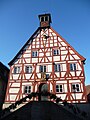
town hall

Salt Gate

_02.jpg)

_04.jpg)
Buildings
Niedernhall's historic town center has been a listed building as a whole since 1983 . In addition to the city wall from the 14th century with battlements , towers and the last remaining city gate , the Salztor , the Laurentiuskirche from the 13th century, the town hall, a historic wine press and the idol house are important architectural monuments of the city. The Hermersberg hunting lodge was built in 1540 on the heights south of Niedernhall.
Museums
The local history museum is also housed in the town hall.
Personalities
- Heinrich August von Hohenlohe-Ingelfingen (1715–1796), born at Hermersberg Castle, director of the Imperial Counts-Franconian College, Field Marshal General
- Philipp Ernst Kern (1716–1776), General Superintendent in Hildburghausen
- Reinhold Würth (* 1935), entrepreneur, has his residence at Hermersberg Castle.
- Anton Baron (* 1987), industrial engineer, politician (AfD), member of the state parliament of Baden-Württemberg since May 2016
Individual evidence
- ↑ State Statistical Office Baden-Württemberg - Population by nationality and gender on December 31, 2018 (CSV file) ( help on this ).
- ↑ Topographic map 1: 25,000 Baden-Württemberg North, as single sheet No. 6623 and 6723.
- ^ The state of Baden-Württemberg. Official description by district and municipality. Volume IV: Stuttgart district, Franconian and East Württemberg regional associations. Kohlhammer, Stuttgart 1980, ISBN 3-17-005708-1 . Pp. 221-222
- ↑ State Statistical Office, area since 1988 according to actual use for Niedernhall.
- ^ Hohenlohekreis: Niedernhall: History. Online at www.hohenlohekreis.de, accessed on October 26, 2014
- Jump up ↑ Karl and Marianne Schumm: Hohenlohische village regulations . Kohlhammer, Stuttgart 1985, ISBN 3-17-008404-6 , p. 705 ( Württembergische rural legal sources . Volume 4) ( Publications of the Commission for Historical Regional Studies in Baden-Württemberg. Series A, Sources. Volume 37)
- ↑ Friedrich Karl Prince of Hohenlohe-Waldenburg: To the forest history of the Hohenlohe country . Reports Freiburg Forest Research, No. 65. Freiburg 2006. ISSN 1436-1566 . P. 4
- ^ Henry Doll: landslide victory for Achim Beck . In: Heilbronn voice from May 4, 2014 ( online )
- ↑ http://www.stimme.de/heilbronn/free/Fast-80-Prozent-Erdrutschsieg-fuer-Achim-Beck-in-Niedernhall;art132111,3082666
- ↑ Heinz Bardua: The district and community coats of arms in the Stuttgart administrative region . Theiss, Stuttgart 1987, ISBN 3-8062-0801-8 (district and municipality coat of arms in Baden-Württemberg, 1). P. 106
- ↑ sueddeutsche.de: "Würths Welt" ( Memento of the original from February 10, 2009 in the Internet Archive ) Info: The archive link was inserted automatically and has not yet been checked. Please check the original and archive link according to the instructions and then remove this notice. (as of January 5, 2009)
literature
- Festschrift for the 600th anniversary of the city of Niedernhall. City of Niedernhall, Niedernhall 1956
- Jürgen Hermann Rauser: Niedernhaller Heimatbuch , Künzelsau 1981
Web links
- Link catalog on the subject of Niedernhall at curlie.org (formerly DMOZ )

Bretzfeld | Dörzbach | Forchtenberg | Ingelfingen | Krautheim | Künzelsau | Copper cell | Mulfingen | Neuenstein | Niedernhall | Öhringen | Pfedelbach | Schöntal | Waldenburg | Weissbach | Doubts