
Stuttgart administrative district
| coat of arms | map |
|---|---|

|

|
| Basic data | |
|
|
| Administrative headquarters : | Stuttgart |
| Surface: | 10,557.57 km² |
| Residents: | 4,143,418 (December 31, 2018) |
| Population density : | 392 inhabitants per km² |
| District structure: | 2 urban districts and 11 rural districts with a total of 343 municipalities |
| Regional Council | |
| District President : | Wolfgang Reimer ( Alliance 90 / The Greens ) |
| Address of the regional council: | Ruppmannstrasse 21 70565 Stuttgart |
| Website: | Regional Council Stuttgart |
| Location of the Stuttgart administrative district in Baden-Württemberg | |
  |
|
The administrative district of Stuttgart is one of four administrative districts in the state of Baden-Württemberg ( Germany ). It stands in the hierarchy between the rural and urban districts on the one hand and the state government on the other.
geography
The Stuttgart administrative region is located in the northeast of Baden-Württemberg. It stretches from Geislingen to Wertheim, from Crailsheim to Herrenberg. In addition to the central Neckar area, a business location of European standing, you will find equally famous landscapes such as the "Liebliche Taubertal", the Hohenlohe plain, the Swabian-Franconian Forest or the Eastern Alb. He is the successor to the administrative district of North Württemberg , which was dissolved on December 31, 1972 . This one had a slightly different cut. In the south it borders on the administrative district of Tübingen , in the west on the administrative district of Karlsruhe , in the north and east on Bavaria . Its current expansion goes back to the administrative and territorial reform on January 1, 1973.
Division of space
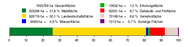
According to data from the State Statistical Office , as of 2015.
history
The administrative district of Stuttgart has existed in its current boundaries since 1973, the former administrative district of North Württemberg was established when the southwestern state of Baden-Württemberg was formed in 1952. Its authority, the regional council, has since then been mainly responsible for the northern part of the former state of Württemberg and the Württemberg part of the state of Württemberg-Baden (capital Stuttgart), which emerged from the American occupation zone after the Second World War . The administrative district was therefore initially called the administrative region of North Württemberg. During the territorial reform, which came into force on January 1, 1973, the area of responsibility of the regional council of Stuttgart was expanded to include former Baden areas in the north. In return, areas were transferred to the jurisdiction of the regional councils of Karlsruhe and Tübingen. Therefore, the administrative region of North Württemberg was renamed the administrative region of Stuttgart at the time .
Population development
The population figures are census results (¹) or official updates from the Baden-Württemberg State Statistical Office ( main residences only ).
|
|
organization

The regional council of Stuttgart is located within the administrative organization of the state of Baden-Württemberg as an intermediate authority between the ten state ministries and the district council and mayor's offices.
As a political official, the district president represents the state government in the Stuttgart administrative region and ensures that statutory tasks and state political goals are implemented. He is represented by the government vice-president.
The regional council employs around 2,600 people in 9 specialist departments with 65 units, including lawyers, administrators, teachers, technicians, road construction engineers, doctors, pharmacists, biologists, fisheries experts and economists.
The regional presidents (since 1952):
- 1952–1967: Wilhelm Schöneck
- 1967–1977: Friedrich Roemer
- 1977–1989: Manfred Bulling
- 1989-2007: Udo Andriof
- 2008–2016: Johannes Schmalzl
- since June 1, 2016: Wolfgang Reimer
Administrative division
- Three regions (→ regional association )
- Eleven rural districts and two urban districts
- 343 cities and municipalities , including two urban districts and 38 large district towns
The Baden-Württemberg regional councils are in the administrative hierarchy between the ministries and the lower administrative authorities (district offices, mayor offices of the city districts and large district towns, administrative communities).
The position of the regional council Stuttgart in the state administration:
The regions with their urban and rural districts:
- Stuttgart region
- City district Stuttgart (S)
- District of Böblingen (BB)
- Esslingen district (ES)
- District of Göppingen (GP)
- District of Ludwigsburg (LB)
- Rems-Murr-District (WN)
- Heilbronn-Franconia region
- Heilbronn district (HN)
- Heilbronn district (HN)
- Hohenlohe District (KÜN)
- Main-Tauber District (TBB)
- District of Schwäbisch Hall (SHA)
- East Württemberg region
- Heidenheim district (HDH)
- Ostalbkreis (AA)
The 38 major district towns (subject to the technical supervision of the regional council):
- Bask
- Backnang
- Bad Mergentheim
- Bad Rappenau
- Bietigheim-Bissingen
- Boeblingen
- Crailsheim
- Ditzingen
- Eislingen / Fils
- Ellwangen (Jagst)
- Eppingen
- Esslingen am Neckar
- Fellbach
- Filderstadt
- Geislingen an der Steige
- Giengen on the Brenz
- Goeppingen
- Heidenheim an der Brenz
- Herrenberg
- Kirchheim unter Teck
- Kornwestheim
- Leinfelden-Echterdingen
- Leonberg
- Ludwigsburg
- Neckarsulm
- Nürtingen
- Öhringen
- Ostfildern
- Remseck am Neckar
- Schorndorf
- Schwäbisch Gmünd
- Schwäbisch Hall
- Sindelfingen
- Vaihingen an der Enz
- Waiblingen
- Wine town
- Wertheim
- Winnenden
economy
In comparison with the GDP per capita in the EU, expressed in purchasing power parity , the Stuttgart administrative district achieved an index of 162 (EU-28 = 100) (2015), making it one of the wealthiest areas in Germany and Europe.
Web links
Individual evidence
- ↑ State Statistical Office Baden-Württemberg - Population by nationality and gender on December 31, 2018 (CSV file) ( help on this ).
- ↑ Survey of land according to type of actual use in 2015
- ↑ Eurostat. Retrieved August 22, 2018 .
Coordinates: 48 ° 44 ' N , 9 ° 7' E