
Heidenheim district
| coat of arms | Germany map |
|---|---|

|

Coordinates: 48 ° 41 ′ N , 10 ° 9 ′ E |
| Basic data | |
| State : | Baden-Württemberg |
| Administrative region : | Stuttgart |
| Region : | East Württemberg |
| Administrative headquarters : | Heidenheim an der Brenz |
| Area : | 627.14 km 2 |
| Residents: | 132,472 (Dec. 31, 2018) |
| Population density : | 211 inhabitants per km 2 |
| License plate : | HDH |
| Circle key : | 08 1 35 |
| NUTS : | DE11C |
| Circle structure: | 11 municipalities |
| Address of the district administration: |
Felsenstrasse 36 89518 Heidenheim an der Brenz |
| Website : | |
| District Administrator : | Peter Polta |
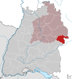
| Location of the Heidenheim district in Baden-Württemberg | |
  |
|
The district of Heidenheim is one of the smallest districts in Baden-Württemberg and its easternmost district. Together with the Ostalbkreis, it forms the Ostwürttemberg region in the Stuttgart administrative region .
geography
location
The district of Heidenheim mainly has a share in the eastern plateau of the Swabian Alb , in the south it extends into the Danube lowlands ( Donauried ). The Brenz flows through the district from north to south , a left tributary of the Danube , which crosses the border at Bächingen and flows into the Danube at Lauingen . The district area extends over an altitude of 435 m above sea level. NN in the Brenztal near Sontheim to 718 m above sea level. NN in the Gewann Bernswang north of Steinheim-Gnannenweiler .
places
The list of places in the Heidenheim district contains around 115 places ( towns , villages , hamlets , farms and living spaces ) in the Heidenheim district in the geographical sense.
Neighboring areas
The district of Heidenheim borders clockwise in the north, starting with the Ostalb district (in Baden-Württemberg), the Bavarian-Swabian districts Donau-Ries , Dillingen an der Donau and Günzburg (all in Bavaria ) as well as the Alb-Donau district and the district of Göppingen (both in turn in Baden-Württemberg).
Division of space

According to data from the State Statistical Office , as of 2015.
Nature reserves
The Heidenheim district has the following nature reserves . According to the protected area statistics of the State Institute for the Environment, Measurements and Nature Conservation Baden-Württemberg (LUBW), 1,198.06 hectares of the district are under nature protection, that is 1.91 percent.
- Brünneleswiesen : 63.8 ha, Heidenheim- Aufhausen and Königsbronn- Itzelberg districts
- Buchhalde-Neresheimer Tal : 7.1 ha; Landmark Großkuchen
- Eselsburger Valley : 318 ha; Gemarkungen Herbrechtingen , Bolheim and Dettingen am Albuch
- Fly Mountain-Kahlhof : 28.0 ha; Frickingen district
- Griesbuckellandschaft Demmingen : 25.2 ha; Demmingen district
- Hülbe am Märtelesberg : 0.2 ha; District Steinheim
- Kürnberg : 12.4 ha; District Giengen
- Ravensburg : 6.1 ha; District Sontheim
- Steinweiler quarry : 7.3 ha; District Auernheim
- Steinheim Basin : 426.1 ha; District Steinheim
- Quarry terraces in the Egautal : 10.7 ha; Gemarkungen Dischingen and Neresheim
- Wental with side valleys and field island Klösterle : 288.7 ha (of which 262.7 ha in the Heidenheim district), districts Steinheim am Albuch and Essingen (Ostalb district)
- Zwing : 102.0 ha (of which 30.1 ha in the Heidenheim district); Municipalities of Dischingen , Nattheim , Neresheim (Ostalbkreis)
history
The district of Heidenheim goes back to the Württemberg Oberamt Heidenheim of the same name , which was established during the time of the Duchy of Württemberg and expanded in 1808 to include the Oberamt Giengen , which only existed for a short time. From 1810 the Oberamt Heidenheim belonged to the Landvogtei am Kocher and from 1818 to the Jagstkreis , which was dissolved in 1924. In 1934 it was renamed the Heidenheim district and in 1938 some communities from the dissolved Neresheim district and some places from the Ulm district were incorporated into the Heidenheim district. In 1945 the district of Heidenheim became part of the newly formed state of Württemberg-Baden , which was merged into the state of Baden-Württemberg in 1952 . From then on he belonged to the administrative region of North Württemberg, which included the Württemberg part of Württemberg-Baden.
The district reform of January 1, 1973 survived unchanged. On July 1, 1974, the place Sontbergen from the Alb-Danube district was added and was incorporated into the municipality of Gerstetten .
After the municipal reform has been completed, the district of Heidenheim still comprises eleven municipalities, including four towns and of these, in turn, two large district towns (Giengen an der Brenz and Heidenheim an der Brenz). The district of Heidenheim is thus the district with the fewest communities in Baden-Württemberg. The largest city is Heidenheim an der Brenz, the smallest municipality is Hermaringen .
Population development
The population figures are census results (¹) or official updates from the Baden-Württemberg State Statistical Office ( main residences only ).
|
|
politics
The district is administered by the district council and the district administrator. The district council is elected for five years by those entitled to vote in the district. This body elects the district administrator for a term of eight years. He is the legal representative and representative of the district as well as the chairman of the district council and its committees, but has no voting rights in the committees. He heads the district office and is an official of the district. His area of responsibility includes the preparation of the district council meetings and its committees. He calls meetings, chairs them and implements the resolutions passed there. His deputy is the first state official.
District administrators
The district councils of the district Heidenheim from 1938:
- 1938–1945: Hermann Ebner
- 1945 : Max Fetzer (acting)
- 1945–1950: Max von Zabern
- 1951–1973: Albert Wild
- 1973-2004: Roland Würz
- 2004–2012: Hermann Mader
- 2012–2019: Thomas Reinhardt
- since 2019: Peter Polta
The Oberamtmen of the former Oberamt Heidenheim from 1803 to 1938 are listed in the article Oberamt Heidenheim .
District council
The district council is elected for five years by those entitled to vote in the district. The local elections on May 26, 2019 led to the following preliminary results.
| Parties and constituencies |
% 2019 |
Seats 2019 |
% 2014 |
Seats 2014 |
% 2009 |
Seats 2009 |
% 2004 |
Seats 2004 |
% 1999 |
Seats 1999 |
% 1994 |
Seats 1994 |
% 1989 |
Seats 1989 |
|
| CDU | Christian Democratic Union of Germany | 25.6 | 12 | 33.0 | 15th | 32.2 | 15th | 34.6 | 16 | - | - | - | - | - | - |
| FW | Free voters | 23.9 | 11 | 22.1 | 10 | 17.8 | 9 | - | - | - | - | - | - | - | - |
| SPD | Social Democratic Party of Germany | 20.3 | 9 | 24.4 | 11 | 25.1 | 12 | 26.4 | 11 | 29.5 | 14th | 29.8 | 16 | 30.6 | 15th |
| GREEN | GREEN and Independent | 19.3 | 9 | 14.7 | 7th | 14.4 | 5 | - | - | - | - | - | - | - | - |
| AfD | Alternative for Germany | 3.4 | 2 | 1.2 | 1 | - | - | - | - | - | - | - | - | - | - |
| FDP | Free Democratic Party | 2.9 | 1 | 1.1 | 1 | 3.9 | 1 | 2.3 | - | 0.7 | - | 1.0 | - | - | - |
| ÖDP / PB | Ecological Democratic Party / Free Citizens | 2.6 | 1 | 1.4 | 1 | 2.8 | 1 | - | - | - | - | - | - | - | |
| THE LEFT. | THE LEFT. | 1.9 | 1 | 2.1 | 1 | 3.8 | 1 | - | - | - | - | - | - | - | - |
| GEM | Joint nomination | - | - | - | - | - | - | 15.6 | 6th | 47.6 | 23 | 53.5 | 29 | 48.9 | 23 |
| Flat share | Electoral associations | - | - | - | - | - | - | 21.1 | 10 | 15.4 | 8th | 6.0 | 2 | 6.6 | 1 |
| REP | The Republicans | - | - | - | - | - | - | - | - | 4.3 | 1 | 7.1 | 3 | 11.8 | 4th |
| Otherwise. | Others | - | - | - | - | - | - | - | - | 2.5 | - | 2.5 | - | 2.1 | - |
| total | 100.0 | 46 | 100.0 | 47 | 100.0 | 44 | 100.0 | 43 | 100.0 | 46 | 100.0 | 50 | 100.0 | 43 | |
| voter turnout | 52.4% | 43.8% | 46.9% | 48.7% | 51.2% | 66.1% | 63.1% | ||||||||
- GEM: Joint election proposal of various parties, including the CDU from 1989 to 1999, without the CDU in the 2004 election. It is no longer possible to understand which individual parties made the joint election proposal during this period.
- WG: Voter associations, as the results from 1989 to 2004 cannot be broken down into individual groups of voters.
coat of arms
The coat of arms of the district of Heidenheim shows a split shield in front in gold a red bar, in the back in black a golden tin tower with black gate and two black windows side by side. The coat of arms was awarded on September 12, 1955.
The red bar symbolizes the Lords of Hellenstein , who ruled the district until the 15th century, the Zinnenturm symbolizes the numerous castles and palaces of the other rulers in the district, which also came to Württemberg at the beginning of the 19th century.
See also: List of coats of arms in the Heidenheim district
Economy and Infrastructure
The Heidenheim district is traditionally industrial. Companies in the mechanical and plant engineering, electrical engineering and textile industries are predominant. The most important employers in the district are Voith , BSH Hausgeräte GmbH , Paul Hartmann AG , Röhm GmbH , Osram , Steiff and Epcos . According to official statistics from the Federal Employment Agency, the district's unemployment rate in August 2013 was 5.4%.
In the future atlas 2016 , the district of Heidenheim was ranked 167th out of 402 districts, municipal associations and urban districts in Germany, making it one of the regions with a "balanced risk-opportunity mix". In the 2019 edition, it was ranked 124 out of 401.
traffic
The Heidenheim tariff association offers a uniform tariff for all local transport services. The Heidenheim district in the Brenz Valley is crossed by the Aalen - Ulm railway line, which was fully opened by the Württemberg State Railway in 1864 to Heidenheim and in 1875/76. The Sontheim-Brenz - Gundelfingen line established a cross connection from the Brenz Railway to the Bavarian Danube Valley from 1911.
The Alb plateau itself was opened up by private railways: In 1901, Badische Lokal-Eisenbahnen AG ran the narrow-gauge Härtsfeldbahn from Aalen via Neresheim to Dischingen and in 1906 to Dillingen an der Donau.
In the western part of the district, Gerstetten received a standard-gauge connection to Amstetten on the Stuttgart-Ulm main line in 1906 by the local railway Amstetten – Gerstetten of the Württemberg Railway Company . Both branch lines lost their passenger traffic; the Härtsfeldbahn in 1972, the other not until 1997. However, a museum railway is still operated here. According to the timetable, passenger traffic from Sontheim-Brenz to Gundelfingen had already been discontinued in 1956, but not formally until 1959.
The federal motorway 7 Ulm - Würzburg runs through the eastern district . Furthermore, several federal, state and district roads open up the district, including the B 19 Ulm - Schwäbisch Hall .
District facilities
The Heidenheim district is responsible for the following vocational schools : Technical School Heidenheim - Heid Tech, Commercial School Heidenheim and Maria-von-Linden School (Home Economics and Agricultural School) Heidenheim, as well as the following special educational and advisory centers : Pistorius School ( specialization focus on intellectual development and physical-motor development with school kindergarten) Herbrechtingen and Arthur-Hartmann-Schule (specialization language) with school kindergartens in Heidenheim.
The Heidenheim district is responsible for the Heidenheim Clinic , the Academic Teaching Hospital of the University of Ulm and the Geriatric Rehabilitation Clinic in Giengen an der Brenz. Both clinics since 1994 as a self-operating out of the district.
The state of Baden-Württemberg is contributing almost 25.6 million euros to the costs for the renovation and expansion of the Heidenheim Clinic. In addition to a new laboratory, measures are planned in the area of patient admission with an emergency treatment station, a station for intensive care and a helicopter landing pad. Work began in early March 2009.
Communities
(Residents on December 31, 2018)
Agreed administrative communities or municipal administration associations
|
|
  |
Municipalities before the district reform
Before the district reform in 1973 and the community reform , the Heidenheim district had a total of 40 communities since 1938 , including three towns . As early as 1937, the Mergelstetten community was incorporated into the town of Heidenheim an der Brenz .
On March 7, 1968, the state parliament of Baden-Württemberg set the course for a community reform. With the law to strengthen the administrative power of smaller municipalities , it was possible for smaller municipalities to voluntarily unite to form larger municipalities. The beginning in the district of Heidenheim made on January 1st, 1971 several communities. The municipality of Oggenhausen was incorporated into the city of Heidenheim an der Brenz, the municipality of Itzelberg into the municipality of Königsbronn and the municipality of Söhnstetten into the municipality of Steinheim am Albuch . In the period that followed, the number of communities steadily decreased. All remaining communities in the Heidenheim district were taken over into the new Heidenheim district on January 1, 1973 , but the number of communities continued to decrease in the period that followed. On July 1, 1974, the municipality was Bräunisheim belonging Sontbergen incorporated into the community Gerstetten, characterized had both the municipal and the county and government district boundaries are shifted as well.
The largest municipality in the Heidenheim district before the district reform was the district town of Heidenheim an der Brenz, which has been a major district town since April 1, 1956 . The smallest community was Hausen ob Lontal.
The district Heidenheim included before the district reform an area of 624 square kilometers , and had in the census in 1970 a total of 127,108 inhabitants. After the district reform, Herbrechtingen (1974) was elevated to the status of town, immediately after Bolheim, the largest municipality in the district, which lost its independence in the course of the last reform, was incorporated into the urban area.
The table shows the population development of the Heidenheim district up to 1970. All population figures are census results.
|
|
The table shows the municipalities of the Heidenheim district before the municipal or district reform.

License Plate
On July 1, 1956, the district was assigned the HDH distinctive sign when the vehicle registration number that is still valid today was introduced . It is still issued today.
literature
- The state of Baden-Wuerttemberg - official description according to districts and municipalities (in eight volumes); Edited by the Baden-Württemberg State Archives Department; Volume IV: Stuttgart District - Regional Associations Franconia and East Wuerttemberg, Stuttgart 1980, ISBN 3-17-005708-1 .
- The nature reserves in the Stuttgart administrative region . Edited by Reinhard Wolf . Jan Thorbecke Verlag, Stuttgart 2002. ISBN 3-7995-5173-5 .
Web links
- Official website of the district
- Literature from and about the district of Heidenheim in the catalog of the German National Library
- Official website for hiking, cycling and leisure activities in the district
Individual evidence
- ↑ a b Statistisches Landesamt Baden-Württemberg - Population by nationality and gender on December 31, 2018 (CSV file) ( help on this ).
- ↑ Survey of land according to type of actual use in 2015
- ↑ LUBW protected area statistics ( Memento from January 20, 2015 in the Internet Archive )
- ↑ a b Federal Statistical Office (ed.): Historical municipality register for the Federal Republic of Germany. Name, border and key number changes in municipalities, counties and administrative districts from May 27, 1970 to December 31, 1982 . W. Kohlhammer, Stuttgart / Mainz 1983, ISBN 3-17-003263-1 , p. 449 f. and 470 .
- ↑ Heidenheim district, November 14, 2011: Thomas Reinhardt is the future district administrator ( page no longer available , search in web archives ) Info: The link was automatically marked as defective. Please check the link according to the instructions and then remove this notice. .
- ↑ Heidenheim district, November 2, 2019: Inauguration: Peter Polta has been the district administrator since December 1
- ↑ Result of the district assembly election 2019 - District Heidenheim: https://www.landkreis-heidenheim.de/Landkreis/PpolitikWahlen/Wahlen/AktuelleWahlen/index.htm
- ↑ https://www.statistik-bw.de/Wahlen/Kommunal/02043000.tab?R=KR135 Result of the district council election 2019
- ↑ [1] Result of the district election 2014
- ↑ [2] Result of the district council election 2009
- ↑ [3] ( page no longer available , search in web archives ) Info: The link was automatically marked as defective. Please check the link according to the instructions and then remove this notice. Distribution of votes in the district council elections 1989–2009
- ↑ [4] ( Page no longer available , search in web archives ) Info: The link was automatically marked as defective. Please check the link according to the instructions and then remove this notice. Distribution of seats in district elections 1989–2009
- ↑ Regional statistical information. In: statistik.arbeitsagentur.de. Statistics from the Federal Employment Agency, accessed on September 27, 2013 .
- ↑ Future Atlas 2016. Archived from the original on October 2, 2017 ; accessed on March 23, 2018 . Info: The archive link was inserted automatically and has not yet been checked. Please check the original and archive link according to the instructions and then remove this notice.
- ↑ Future Atlas 2019. Accessed December 10, 2019 .
- ↑ State Gazette No. 8 of March 6, 2009, page 12.
Alb-Danube District | Baden-Baden | Biberach | Lake Constance district | Boeblingen | Breisgau-Upper Black Forest | Calw | Emmendingen | Enzkreis | Esslingen | Freiburg im Breisgau | Freudenstadt | Göppingen | Heidelberg | Heidenheim | Heilbronn (Land) | Heilbronn (city) | Hohenlohekreis | Karlsruhe (State) | Karlsruhe (city) | Constance | Loerrach | Ludwigsburg | Main-Tauber district | Mannheim | Neckar-Odenwald district | Ortenaukreis | Ostalbkreis | Pforzheim | Rastatt | Ravensburg | Rems-Murr-Kreis | Reutlingen | Rhein-Neckar District | Rottweil | Schwäbisch Hall | Schwarzwald-Baar district | Sigmaringen | Stuttgart | Tübingen | Tuttlingen | Ulm | Waldshut | Zollernalb district
.svg)
Basking | Backnang | Baden-Baden | Balingen | Biberach | Boeblingen | Bruchsal | Book | Bühl | Calw | Crailsheim | Donaueschingen | Ehingen | Emmendingen | Esslingen | Freiburg (city) | Freiburg (State) | Freudenstadt | Friedrichshafen | Göppingen | Hechingen | Heidelberg (city) | Heidelberg (Country) | Heidenheim | Heilbronn (city) | Heilbronn (Land) | Black Forest | Horb | Karlsruhe (city) | Karlsruhe (State) | Throat | Constance (city) | Constance (Country) | Künzelsau | Lahr | Leonberg | Loerrach | Ludwigsburg | Mannheim (city) | Mannheim (State) | Mergentheim | Mosbach | Muellheim | Münsingen | Neustadt | Nürtingen | Offenburg | Öhringen | Pforzheim (city) | Pforzheim (Country) | Rastatt | Ravensburg | Reutlingen | Rottweil | Säckingen | Saulgau | Schwäbisch Gmünd | Schwäbisch Hall | Sigmaringen | Sinsheim | Stockach | Stuttgart | Tauberbischofsheim | Tettnang | Tübingen | Tuttlingen | Überlingen | Ulm (city) | Ulm (State) | Vaihingen | Villingen | Villingen-Schwenningen | Waiblingen | Waldshut | Cheeks | Wolfach