Wolfach district
| coat of arms | Germany map | |
|---|---|---|

|
Coordinates: 48 ° 20 ' N , 8 ° 10' E |
|
| Basic data (as of 1972) | ||
| Existing period: | 1938-1972 | |
| State : | Baden-Württemberg | |
| Administrative region : | South Baden | |
| Administrative headquarters : | Wolfach | |
| Area : | 641 km 2 | |
| Residents: | 57,262 (May 27, 1970) | |
| Population density : | 89 inhabitants per km 2 | |
| License plate : | WOL | |
| Circle key : | 08 3 48 | |
| Circle structure: | 30 parishes | |
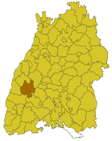
| Location of the district of Wolfach in Baden-Württemberg | ||
The district of Wolfach was a district in Baden-Württemberg that was dissolved in the course of the district reform on January 1, 1973 .
geography
location
The district of Wolfach was located in the southwest of Baden-Württemberg .
Geographically, the district of Wolfach had a share in the Black Forest . The district town was roughly in the middle of the district.
Neighboring areas
Its neighboring districts were 1972 clockwise starting in the north Offenburg , Freudenstadt , Rottweil , Villingen-Schwenningen , Emmendingen and Lahr .
history
The area of the later district of Wolfach belonged to various domains before 1800, including mainly the Prince of Fürstenberg . In 1803 the area came to Baden , which initially formed several offices , including the offices or district offices Haslach and Wolfach, which later, like the Hornberg office, which was acquired again by Württemberg in 1810, belonged to the regional commissioner district of Freiburg . In 1857 the district offices of Haslach and Hornberg were dissolved. The municipalities of the Haslach office and the municipality of Kirnbach of the Hornberg office were assigned to the Wolfach district office, the remaining municipalities of the Hornberg office to the Triberg district office . In 1864 Gutach also came to the Wolfach district office. In 1924 the Triberg district office was dissolved. This gave the Wolfach district office additional communities. It also received some municipalities from the Offenburg District Office in 1936 when this was enlarged by the dissolution of the Oberkirch District Office . From the enlarged Wolfach district office, the district of Wolfach emerged in 1939, which received two more communities from the district of Lahr and Offenburg. In 1945, however, he returned the community of Prinzbach to the Lahr district.
After the formation of the state of Baden-Württemberg in 1952, the district of Wolfach belonged to the administrative district of South Baden . With effect from January 1, 1973 the district of Wolfach was dissolved. Most of its communities were absorbed into the newly formed Ortenaukreis , which became the legal successor to the Wolfach district. However, four communities in the southeastern district came to the enlarged Rottweil district , and two more communities in the northeast to the enlarged Freudenstadt district .
Population development
All population figures are census results.
|
|
politics
District Administrator
The senior officials or district administrators of the district office or district of Wolfach 1810–1972:
|
|
coat of arms
The coat of arms of the district of Wolfach showed a standing red double hook (Wolfsangel) in a shield divided by black and gold diagonally to the left. The coat of arms was awarded to the Wolfach district on March 30, 1960 by the Baden-Württemberg Ministry of the Interior .
The double hook was taken from the coat of arms of the district town of Wolfach, which in turn carries the wolf hook of the former Lords of Wolfach as the "talking" coat of arms. The shield colors correspond to the Baden-Württemberg state colors.
Economy and Infrastructure
traffic
There was no federal motorway running through the district . Only the federal highways 33 and 294 as well as several district roads opened up the district area.
Communities
As of 1939, the Wolfach district initially consisted of 31 communities, including 6 towns. In 1945 the community of Prinzbach was returned to the district of Lahr.
On March 7, 1968, the state parliament of Baden-Württemberg set the course for a community reform . With the law to strengthen the administrative power of smaller municipalities , it was possible for smaller municipalities to voluntarily unite to form larger municipalities. The beginning in the district of Wolfach was made on July 1, 1971 by the municipality of Einbach, which merged with the city of Hausach . In the period that followed, the number of communities steadily decreased until the Wolfach district was finally dissolved on January 1, 1973.
The largest municipality in the district was the town of Haslach in the Kinzig valley . The smallest community was Oberentersbach.
In the table, the municipalities of the Wolfach district are before the municipal reform. The population figures refer to the census results in 1961 and 1970.
License Plate
On July 1, 1956, the district was assigned the distinctive sign WOL when the vehicle registration number that is still valid today was introduced . It was issued until December 31, 1972. It has been available in the Ortenau district since March 31, 2014 due to the license plate liberalization . It has also been available in the Freudenstadt district since February 19, 2018.
Individual evidence
- ↑ a b Federal Statistical Office (ed.): Historical municipality register for the Federal Republic of Germany. Name, border and key number changes in municipalities, counties and administrative districts from May 27, 1970 to December 31, 1982 . W. Kohlhammer, Stuttgart / Mainz 1983, ISBN 3-17-003263-1 , p. 506 .


