
Tuttlingen district
| coat of arms | Germany map |
|---|---|

|

Coordinates: 47 ° 59 ' N , 8 ° 48' E |
| Basic data | |
| State : | Baden-Württemberg |
| Administrative region : | Freiburg |
| Region : | Schwarzwald-Baar-Heuberg |
| Administrative headquarters : | Tuttlingen |
| Area : | 734.35 km 2 |
| Residents: | 140,152 (Dec. 31, 2018) |
| Population density : | 191 inhabitants per km 2 |
| License plate : | DOES |
| Circle key : | 08 3 27 |
| NUTS : | DE137 |
| Circle structure: | 35 municipalities |
| Address of the district administration: |
Bahnhofstrasse 100 78532 Tuttlingen |
| Website : | |
| District Administrator : | Stefan Bär ( Free Voters ) |
| Location of the Tuttlingen district in Baden-Württemberg | |
  |
|
The district of Tuttlingen is a district in Baden-Württemberg . It belongs to the Schwarzwald-Baar-Heuberg region in the Freiburg administrative region .
geography
location
The district of Tuttlingen mainly comprises parts of the Swabian Alb ( Heuberg , Baaralb and Hegaualb with the transition to the Upper Swabian Alpine Foreland) and the Gaulandschaft of the Alb foreland ( Baar ) in the west. The highest point is the Lemberg with 1015.7 m above sea level. NHN , the lowest point is in the Hattinger Valley at 570 m above sea level. NHN . The largest areas of the district are 31 km (east-west) and 38 km (north-south).
Neighboring areas
The district borders in a clockwise direction in the northwest on the districts of Rottweil , Zollernalbkreis , Sigmaringen , Konstanz and Schwarzwald-Baar-Kreis .
Division of space

According to data from the State Statistical Office , as of 2015.
Nature reserves
The Tuttlingen district has the following 25 nature reserves . According to the protected area statistics of the State Institute for the Environment, Measurements and Nature Conservation Baden-Württemberg (LUBW), 2,443.51 hectares of the district are under nature protection, that is 3.33 percent.
- Albtrauf Baar : 365.6 hectares; Cities of Bad Dürrheim , Geisingen and Immendingen
- Old mountain : 45.5 ha; community Böttingen
- Buchhalde-Upper Danube Valley : 302.9 ha; Cities Fridingen an der Donau and Mühlheim an der Donau
- Dürbheimer Moos : 63.9 ha; Municipalities of Balgheim and Dürbheim
- Schwandorf wet meadows : 114.4 ha; Municipalities of Neuhausen ob Eck and Sauldorf
- Galgenberg : 12.9 ha; City of Mühlheim an der Donau
- Gallows meadows : 28.0 ha; Municipality of Bärenthal , Egesheim and Nusplingen
- Mother grass : 10.1 ha; Dürbheim community
- Hintelestal : 19.1 ha; Kolbingen municipality
- Hohenkarpfen : 13.7 ha; Community of Hausen ob Verena
- Höwenegg : 20.7 ha; Immendingen community
- Hüttenberg : 37.1 ha; Community Bärenthal
- Irrendorfer Hardt : 104.9 ha; Irndorf municipality
- Klippeneck : 9.2 ha; Community Denkingen
- Power stone : 59.8 ha; City of Mühlheim an der Donau
- Ortenberg : 71.6 ha; Deilingen municipality
- Schloßhalde-Mannsteighalde : 55.8 ha; community Wehingen
- Schopfeln-Rehletal : 173.0 ha; Immendingen municipality and Engen city
- Simonstal : 46.3 ha; Irndorf municipality
- Staudlin-Hornenberg : 62.9 ha; Immendingen community
- Stettener Halde : 8.3 ha; City of Mühlheim an der Donau
- Stiegelesfels-Upper Danube Valley : 342.4 ha; City of Fridingen on the Danube and the municipality of Buchheim
- Shoot pile : 9.2 ha; City of Mühlheim an der Donau
- Trobenholz-Vogelbühl : 78.3 ha; Municipalities of Bärenthal and Irndorf
- Unterholz forest : 633.9 ha; Cities Bad Dürrheim and Donaueschingen , municipality Geisingen
history
In early history, the area around Tuttlingen was probably located in the settlement area of the Celtic Tulingers , who from 15 BC onwards. Were subjugated and romanized by the Roman Empire . As part of the later Roman province of Upper Germany , the region lay on the Upper German-Raetian Limes on the Donausüdstraße ( via iuxta Danuvium ) until around 95 AD . At that time there was probably a fort in the area of today's Tuttlingen old town . Due to the dense settlement of the area nowadays, excavations have not been carried out so far, so that very little is known about the Tuttlingen fort . After the withdrawal of the Roman legions, the Suebi and / or Alamanni settled in the local area.
Today's district area has an eventful history of its territorial affiliation. In the Carolingian era it was the rulership of various noble families, the upper Danube z. B. the Alaholfinger or Bertholde. After the fall of the Frankish Empire in 843, the area belonged to Eastern Franconia and from around 920 to the Duchy of Swabia . After its end, in 1273 under Rudolf II , it largely became part of the Habsburg Front Austria and the Principality of Fürstenberg of the Swabian Empire .
After the Napoleonic wars, the area was mainly assigned to the Kingdom of Württemberg in 1806 , but there were several small exclaves at Hohenzollern-Hechingen and Hohenzollern-Sigmaringen , which were dissolved together in the then Prussian Hohenzollern Lands in 1849 , which were only cleared up late through the swap of territories.
The Wuerttemberg Oberamt Tuttlingen was established as early as the 15th century, which was rewritten in 1806 and changed several times afterwards. In 1842, for example, the community of Schwenningen am Neckar was given to the Oberamt Rottweil . The Oberamt Spaichingen was formed in 1806 from mostly Austrian areas . From 1810 both senior offices belonged to the Landvogtei on the upper Neckar and from 1818 to the Black Forest district , which was dissolved in 1924. In 1934 both senior offices were renamed to districts and in 1938 the district of Spaichingen was dissolved. Most of the communities came to the Tuttlingen district, some to the Balingen district .
After 1945 the district of Tuttlingen belonged to the state of Württemberg-Hohenzollern , which was added to the state of Baden-Württemberg in 1952. From then on, the district belonged to the administrative district of Südwürttemberg-Hohenzollern .
During the district reform , the district of Tuttlingen received some Baden communities from the dissolved districts of Donaueschingen and Stockach on January 1, 1973, and the community of Bärenthal from the district of Sigmaringen ; he gave the municipality of Tuningen to the Schwarzwald-Baar district . Since then it has belonged to the Freiburg administrative district .
On June 1, 1972, the community of Eßlingen from the Donaueschingen district was added. It was incorporated into the district town of Tuttlingen .
After the community reform has been completed, the district of Tuttlingen will comprise 35 communities, including six cities, of which Tuttlingen is a major district town . The largest city is Tuttlingen, the smallest municipality is Bärenthal.
Population development
The population figures are census results (¹) or official updates from the Baden-Württemberg State Statistical Office (main residences only).
|
|
The fertility rate of 1.6 children per woman in 2008 was the highest in Baden-Württemberg, and the district is demographically one of the best in all of Germany.
politics
The district is administered by the district council and the district administrator. The district council elects the district administrator for a term of office of 8 years. He is the legal representative and representative of the district as well as chairman of the district council and its committees, but has no voting rights in the committees . He heads the district office and is an official of the district. His area of responsibility includes the preparation of the district council meetings and its committees. He calls meetings, chairs them and implements the resolutions passed there. His deputy is the first state official .
District council
The district council is elected for five years by those entitled to vote in the district. The local elections on May 26, 2019 led to the result shown in the diagrams.
- Results of previous district council elections
| Parties and constituencies | % 2014 |
Seats 2014 |
% 2009 |
Seats 2009 |
% 2004 |
Seats 2004 |
% 1999 |
Seats 1999 |
% 1994 |
Seats 1994 |
% 1989 |
Seats 1989 |
|
|---|---|---|---|---|---|---|---|---|---|---|---|---|---|
| CDU | Christian Democratic Union of Germany | 43.0 | 19th | 42.2 | 21st | 47.6 | 25th | 48.4 | 23 | 44.4 | 23 | 46.9 | 24 |
| FW | Free voters | 20.8 | 8th | 18.9 | 9 | - | - | - | - | - | - | - | - |
| Flat share | Electoral associations | - | - | - | - | 29.2 | 13 | 20.2 | 9 | 17.8 | 8th | 21.4 | 9 |
| OGL | Open green list | 14.2 | 6th | 12.4 | 5 | - | - | - | - | - | - | - | - |
| GREEN | Alliance 90 / The Greens | - | - | - | - | - | - | 7.3 | 3 | 8.5 | 3 | - | - |
| SPD | Social Democratic Party of Germany | 13.8 | 6th | 13.7 | 6th | 15.0 | 6th | 17.8 | 6th | 20.2 | 8th | 20.6 | 8th |
| FDP | Free Democratic Party | 8.4 | 4th | 12.8 | 6th | 8.2 | 4th | 6.2 | 3 | 6.6 | 3 | 6.0 | 3 |
| Otherwise. | Others | - | - | - | - | - | - | - | - | 2.5 | - | 5.1 | 1 |
| total | 100 | 43 | 100 | 47 | 100 | 48 | 100 | 44 | 100 | 45 | 100 | 45 | |
| voter turnout | 48.3% | 51.6% | 53.3% | 56.8% | 70.7% | 68.0% | |||||||
- WG: Voter associations, as the results from 1989 to 2004 cannot be broken down into individual groups of voters.
- Other: the 1 seat in the years 1989 to 1994 was Martin Mußgnug ( NPD ).
District Administrator

The district councilor is elected by the district council for a term of eight years. He is the legal representative and representative of the district as well as the chairman of the district council and its committees, but has no voting rights in the committees . He heads the district office and is an official of the district. His area of responsibility includes the preparation of the district council meetings and its committees. He calls meetings, chairs them and implements the resolutions passed there. His deputy is the first state official.
The Oberamtmen of the former Oberamt from 1807 to 1934 are shown under Oberamt Tuttlingen .
The district councils of the district Tuttlingen since 1934
- 1933–1937: Hermann Rieger , NSDAP
- 1938–1946: Eduard Quintenz , NSDAP
- 1946–1947: Erich Schariry (office administrator)
- 1947–1949: Fritz Erler , SPD
- 1950–1963: Kurt Geiger , CDU
- 1963–1978: Hans Köpf , CDU
- 1979–2003: Hans Volle , CDU
- 2003–2011: Guido Wolf , CDU
- since 2012: Stefan Bär , free voter
County finances
The district's debt level at the end of 2008 was EUR 34.7 million.
coat of arms

Coat of arms until 1973

|
|
Blazon : "In a divided shield above in gold a lying black deer pole , below in blue a four-spoke golden wheel below." |
| Justification of the coat of arms: The stag bar symbolizes Württemberg , to which Tuttlingen, Trossingen and smaller towns have belonged since 1444. The wheel stands for the Upper Austrian county of Hohenberg , to which Spaichingen belonged. The coat of arms shows that the district was formed in 1938 from the former Tuttlingen and Spaichingen authorities. The coat of arms was newly awarded on February 28, 1961 and after the district reform on October 12, 1973. |
Economy and Infrastructure
economy
The Tuttlingen district is doing very well economically (18th of over 400 in Germany, fourth in Baden-Württemberg, first outside the Stuttgart region ) and has low unemployment, especially youth unemployment. The district is the district with the highest number of jobs in Germany.
In the Future Atlas 2016, the district of Tuttlingen was ranked 64th out of 402 districts, municipal associations and independent cities in Germany, making it one of the places with "high future opportunities".
Mining
In pits, peasant ore was extracted by farmers during the poor months. Analyzes of the slag from historical iron smelting show a type of small smelting furnace that has been able to smelt all ores in the area since the 13th century. Iron ore , floor ore and iron rye stone were transported to the blast furnaces of the Schwäbische Hüttenwerke in Tuttlingen. The Harras smelter was shut down in 1832. The former Hammer steelworks is now used for the regional water supply . Iron ore was mined in the Tuttlingen district until 1870, and basalt was mined on Höwenegg until 1979 . Untersteiger Bosch opened a 3.5 km long tunnel in Weilheim for the blast furnaces in Ludwigsthal, which were suffering from a shortage of ore . Restored woods are on display in the Tuttlinger Fruchtkasten. A lentil ore was mined from the 1.6 m thick seam in the macrocepal layer . Today limestone is mined in the Tuttlingen district.
traffic


The traffic in the Tuttlingen district is characterized by the long-distance connections Stuttgart - Zurich / Lake Constance in north-south and Ulm - Freiburg im Breisgau in the east-west direction. The low mountain range, especially the Great Heuberg, is a restriction for large traffic axes .
rail
The Tuttlingen district is accessed by a total of five active railway lines. In detail these are:
- the Gäubahn from Stuttgart to Singen (Hohentwiel) in the Aldingen - Spaichingen - Tuttlingen section
- the Tuttlingen – Inzigkofen line in the Tuttlingen – Fridingen section
- the Wutach Valley Railway from Immendingen to Waldshut in the Geisingen-Leipferdingen –Immendingen section
- the Black Forest Railway from Offenburg to Konstanz in the Geisingen – Immendingen section
- the Trossingen Railway
In long-distance traffic is Tuttlingen maintenance of the two-hour clock trains running intercity trains between Stuttgart and Zurich . Aldingen, Spaichingen, Tuttlingen, Geisingen, Immendingen and Fridingen are directly connected to national public transport . Since the implementation of the Ringzug concept in 2003, local transport in particular has improved significantly in the district. Today, a large number of the municipalities in the district again have their own train stop and on weekdays there is usually an hourly ring train service. In total there are 28 active train stops in the district today, eight of them in the area of the city of Tuttlingen alone. The TUTicket transport association is responsible for local transport in the district .
Street
The district area is touched in the extreme southwest of the federal highway 81 Stuttgart - Singen (Hohentwiel) . Furthermore, around 90 km of federal roads, over 200 km of state roads and around 150 km of district roads open up the district. The B 14 Stuttgart - Stockach runs through the district from northwest to southeast. The B 523 connects Tuttlingen with the regional center of Villingen-Schwenningen . The federal highways 31 and 311 running through the district form an important east-west axis ( Freiburg im Breisgau - Ulm ) in Baden-Württemberg. And the B 491 leads via Emmingen-Liptingen to Engen im Hegau .
District facilities
The Tuttlingen district is responsible for the following vocational schools : Ferdinand-von-Steinbeis-Schule (commercial schools) Tuttlingen, commercial and home economics schools in Tuttlingen and vocational schools in Spaichingen, as well as the following special educational and advisory centers : Johann-Peter-Hebel-Schule with school kindergarten Tuttlingen (Focus on intellectual development) and Otfried Preussler School with Kindergarten in Balgheim (focus on language).

The Tuttlingen district is also responsible for the Tuttlingen district hospital with the Tuttlingen health center and Spaichingen health center. He also maintains the Tuttlingen District Media Center and the Tuttlingen Social Psychiatric Service.
Culture and sights
The district operates its own regional rural open-air museum in Neuhausen ob Eck . In this museum village, the rural history of the district and the region is clearly presented.
Since 2004, the district of Tuttlingen has organized its own cultural events as part of the KreisKunstKultur series. In addition, the Große Heuberg is advertised more intensively as a region of ten thousand and large parts of the district as "Donaubergland" ( Obere Donau Nature Park , Donauberglandweg ). This is to counteract the fact that the district belongs to the bottom 15% of all German districts in terms of the number of overnight stays.
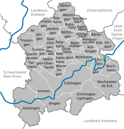
Communities
(Residents on December 31, 2018)
Agreed administrative communities and municipal administration associations
|
Other communities
|
  |
The old district of Tuttlingen
Before the district reform on January 1, 1973 and before the community reform , the Tuttlingen district had a total of 37 communities since 1938 , including five towns . The municipality of Irrendorf was spatially separated from the actual district area. In between was the municipality of Bärenthal belonging to the district of Sigmaringen .
On March 7, 1968, the state parliament of Baden-Württemberg set the course for a community reform . With the law to strengthen the administrative power of smaller municipalities , it was possible for smaller municipalities to voluntarily unite to form larger municipalities. The beginning in the old district of Tuttlingen was made on December 1, 1971 by the community of Schura, which merged with the city of Trossingen . In the period that followed, the number of communities steadily decreased.
In 1972 the municipality of Irrendorf was renamed Irndorf.
The remaining municipalities of the old Tuttlingen district merged into the new, enlarged Tuttlingen district on January 1, 1973, with only Tuningen moving to the Schwarzwald-Baar district .
The largest municipality in the old Tuttlingen district was the city of Tuttlingen, which has been a major district town since April 1, 1956 . The smallest community was Reichenbach am Heuberg.
The old district Tuttlingen included last an area of 455 square kilometers , and had in the census in 1970 a total of 90,380 inhabitants.
The table shows the population development of the old Tuttlingen district up to 1970. All population figures are census results.
|
|
In the table, the municipalities of the old Tuttlingen district are before the municipal reform. All communities still belong to the Tuttlingen district, with the exception of Tuningen, which is part of the Schwarzwald-Baar district.

License Plate
On July 1, 1956, the district was assigned the TUT distinctive sign when the license plates that are still valid today were introduced . It is issued continuously to this day.
literature
- Tuttlingen district. (= The city and rural districts of Baden-Württemberg in words and numbers; Issue 52) . Published by the Ministry of the Interior and Ministry of Economics of Baden-Württemberg, processing and printing of the State Statistical Office of Baden-Württemberg, Stuttgart, 1970.
- The state of Baden-Württemberg - official description by district and municipality (in eight volumes); Edited by the Baden-Württemberg State Archives Directorate; Volume VI: Freiburg administrative region; Stuttgart 1982, ISBN 3-17-007174-2
- Archeology, art and landscape in the Tuttlingen district . Edited by the Tuttlingen district, Thorbecke, Sigmaringen 1988, ISBN 3-7995-4111-X
Web links
- Official website of the district
- Information on tourism in the Tuttlingen district
- Literature on the Tuttlingen district in the catalog of the German National Library
Individual evidence
- ↑ Baden-Württemberg State Statistical Office - Population by nationality and gender on December 31, 2018 (CSV file) ( help ).
- ↑ Survey of land according to type of actual use in 2015
- ↑ LUBW protected area statistics as of December 8, 2018
- ^ Wolfgang Menzel : History of the Germans up to the newest days, Volume 1 , Cotta, 1843, p. 54.
- ↑ See: territorial peculiarities in southwest Germany after 1810
- ↑ a b Federal Statistical Office (ed.): Historical municipality directory for the Federal Republic of Germany. Name, border and key number changes in municipalities, counties and administrative districts from May 27, 1970 to December 31, 1982 . W. Kohlhammer, Stuttgart / Mainz 1983, ISBN 3-17-003263-1 , p. 518, 535 f .
- ↑ Tuttlingen district with the highest birth rate in Baden-Württemberg. (No longer available online.) Baden-Württemberg State Statistical Office, September 2, 2009, archived from the original on September 27, 2009 ; Retrieved September 4, 2009 (press release no. 277/2009).
- ↑ The nationwide ranking, sorted by demographics. (No longer available online.) INSM Regional Ranking 2009, archived from the original on August 17, 2012 ; Retrieved August 28, 2012 . Info: The archive link was inserted automatically and has not yet been checked. Please check the original and archive link according to the instructions and then remove this notice.
- ↑ landkreis-tuttlingen.de
- ↑ statistik.baden-wuerttemberg.de ( page no longer available , search in web archives ) Info: The link was automatically marked as defective. Please check the link according to the instructions and then remove this notice. Distribution of votes in the district elections 1989–2009
- ↑ statistik.baden-wuerttemberg.de ( page no longer available , search in web archives ) Info: The link was automatically marked as defective. Please check the link according to the instructions and then remove this notice. Distribution of seats in district elections 1989–2009
- ↑ Schwäbische Zeitung (regional edition "Gränzbote") of December 18, 2008, article: "District invests 15 million euros"
- ↑ INSM regional ranking 2009: The nationwide ranking, sorted by job supply ( Memento from August 16, 2012 in the Internet Archive )
- ↑ Future Atlas 2016. (No longer available online.) Archived from the original on October 2, 2017 ; accessed on March 23, 2018 . Info: The archive link was inserted automatically and has not yet been checked. Please check the original and archive link according to the instructions and then remove this notice.
- ↑ : Iron Industry . In: Schwarzwälder Bote , September 28, 2016.
- ↑ : Rennofen . In: Reutlinger Generalanzeiger , May 22, 2007.
- ^ Martin Kemp: Medieval ironworks , Schwäbisch Gmünd.
- ↑ State Archive of Baden-Wuerttemberg Abt.Wirtschaftsarchiv Stuttgart Hohenheim (ed.): Archive SHW . Harras, Ludwigsthal.
- ↑ Memminger: Yearbook 1839 . S. 352 .
- ↑ Fruchtkasten: [https://www.tuttlingen.de/de/Die-Stadt/Tuttlingen-aktuell/Pressemitteilungen/Pressemitteilung?view=publish&item=article&id=6581 tuttlingen.de Ludwigsthal department]. In: press releases. November 21, 2016.
- ↑ donaubergland.de
- ↑ INSM regional ranking 2009: The nationwide ranking, sorted according to overnight stays ( memento from August 16, 2012 in the Internet Archive )
- ↑ Baden-Württemberg State Statistical Office - Population by nationality and gender on December 31, 2018 (CSV file) ( help ).
Alb-Danube District | Baden-Baden | Biberach | Lake Constance district | Boeblingen | Breisgau-Upper Black Forest | Calw | Emmendingen | Enzkreis | Esslingen | Freiburg im Breisgau | Freudenstadt | Göppingen | Heidelberg | Heidenheim | Heilbronn (Land) | Heilbronn (city) | Hohenlohekreis | Karlsruhe (State) | Karlsruhe (city) | Constance | Loerrach | Ludwigsburg | Main-Tauber district | Mannheim | Neckar-Odenwald district | Ortenaukreis | Ostalbkreis | Pforzheim | Rastatt | Ravensburg | Rems-Murr-Kreis | Reutlingen | Rhein-Neckar District | Rottweil | Schwäbisch Hall | Schwarzwald-Baar district | Sigmaringen | Stuttgart | Tübingen | Tuttlingen | Ulm | Waldshut | Zollernalbkreis
.svg)
Basking | Backnang | Baden-Baden | Balingen | Biberach | Boeblingen | Bruchsal | Book | Bühl | Calw | Crailsheim | Donaueschingen | Ehingen | Emmendingen | Esslingen | Freiburg (city) | Freiburg (State) | Freudenstadt | Friedrichshafen | Göppingen | Hechingen | Heidelberg (city) | Heidelberg (Country) | Heidenheim | Heilbronn (city) | Heilbronn (Land) | Black Forest | Horb | Karlsruhe (city) | Karlsruhe (State) | Throat | Constance (city) | Constance (Country) | Künzelsau | Lahr | Leonberg | Loerrach | Ludwigsburg | Mannheim (city) | Mannheim (State) | Mergentheim | Mosbach | Muellheim | Münsingen | Neustadt | Nürtingen | Offenburg | Öhringen | Pforzheim (city) | Pforzheim (Country) | Rastatt | Ravensburg | Reutlingen | Rottweil | Säckingen | Saulgau | Schwäbisch Gmünd | Schwäbisch Hall | Sigmaringen | Sinsheim | Stockach | Stuttgart | Tauberbischofsheim | Tettnang | Tübingen | Tuttlingen | Überlingen | Ulm (city) | Ulm (State) | Vaihingen | Villingen | Villingen-Schwenningen | Waiblingen | Waldshut | Cheeks | Wolfach