Hegaualb
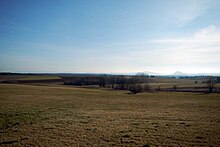
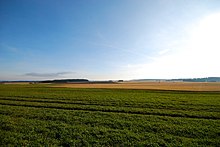
The Hegaualb is a landscape in the south of Baden-Württemberg between the uppermost Danube and the Hegau northwest of Lake Constance. Geologically, it is part of the Swabian Alb , of which it forms the most south-westerly foothills. In the natural structure of Germany, it is the main unit No. 091 in the south-west German stepland .
Location and area
Another name is Badischer Heuberg . Your part between Möhringen an der Donau and Bergsteig is called "Die Eck" or Egg. Politically, the Hegaualb belongs to the Schwarzwald-Baar district , the district of Constance and the district of Tuttlingen . In the south it merges into the Hegau , in the south-west it is bordered by the Randen (Canton Schaffhausen) and in the west by the Alb-Wutach area . In the north the upper Danube valley forms the border to the Baaralb , in the east the Danube-Ablach-Platten adjoin .
The Hegaualb lies at the transition to the Alpine foothills . Their area is about 413 km². The Hegaualb extends up to 50 kilometers from NE-SW and up to 12 kilometers from NW-SE.
mountains
The highest mountain in the Hegaualb is the Neuhewen at 867 m above sea level. Other well-known elevations are the Witthoh ( 862 m above sea level ), the Höwenegg (812 m above sea level) and a 763 m high ridge, at the end of which the Homburg towers.
Landscape type
It is assigned to the landscape type of a structured forest landscape. In addition to the predominant spruce stands , some beech stands shape the landscape. The remaining areas are predominantly agricultural land.
towns and places
- Districts of Blumberg : Kommingen and Riedöschingen
- Buchheim (south of the Danube breakthrough near Beuron )
- Emmingen-Liptingen (southeast of Tuttlingen )
- Engen with Bargen , Biesendorf , Bittelbrunn , Stetten and Zimmerholz
- Districts of Eigeltingen : Glashütte, Heudorf im Hegau, Honstetten, Reute im Hegau and Rorgenwies
- Districts of Immendingen : Hattingen , Mauenheim
- Leibertingen
- District of Geisingen : Leipferdingen
- Neuhausen ob Eck with Worndorf
- Tengen with Blumenfeld , Büßlingen and Watterdingen
swell
- Natural area profile Hegaualb (091) (Note: The small BW portion of the Randen (090) is integrated here.) - LUBW (PDF; 8.8 MB; Notes )
- Landscape profile Hegaualb of the BfN (much less detailed)


