Witthoh
| Witthoh | ||
|---|---|---|
| height | 862 m above sea level NHN | |
| location | Baden-Wuerttemberg , Germany | |
| Coordinates | 47 ° 56 '10 " N , 8 ° 49' 36" E | |
|
|
||
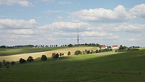
The Witthoh is a mountain range ( 862 m above sea level ), a panoramic mountain and the location of the Witthoh transmitter south of Tuttlingen in Baden-Württemberg .
Geography and landscape
The mountain lies between Tuttlingen, Hattingen and Emmingen . It is part of the Die Egg ridge , which in turn is part of the Hegaualb between the Swabian Alb and Lake Constance. On the north side it is consistently covered by dense forest, to the south meadows, fields and farms predominate.
The ridge separates the harsh climate of the Alb from the milder influence of Lake Constance. In spring, nature is at least three weeks further south of Witthoh than in the Danube valley to the north. The ridge is part of the main European watershed between the North Sea and the Black Sea . Precipitation falling on the south side flows via Lake Constance and the Rhine into the North Sea , while areas to the north drain into the Black Sea via the Danube.
traffic
The Witthoh can be reached via the road from Emmingen from Egg to Hattingen .
From Tuttlingen there is another option via the Witthohsteige . This narrow road, which was laid out in the 18th century, has a steep ascent (up to 14%) at the beginning and then leads as an elevated road (as shown on the topographic maps) over the plateau to Witthoh. Motor vehicles may only enter it on weekdays; in the winter months it is closed to motor vehicles.
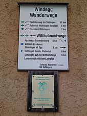
The Hohenzollern cycle path , which passes close to the transmission tower, also leads over the Witthohsteige . Cyclists traveling on the Danube Cycle Path can get to Witthoh from Möhringer Vorstadt on a signposted and paved, gently ascending, six-kilometer cycle path through the Goggen and Rabental valleys.
Tourism and sport
With hiking trails, the Witthoh is accessible from the south through the paths of the Black Forest Association, from the north through the paths of the Swabian Alb Association , since Emmingen was formerly part of Baden, but Tuttlingen was part of Württemberg.
As a hiking and panoramic mountain, the Witthoh is visited by hundreds of walkers, especially on weekends and when the weather is clear. On clear days, the view extends from the Bavarian Alps from the Zugspitze in the east to far to the southwest to the four-thousand-meter peaks of the Bernese Oberland , which is around 300 kilometers in length. In the foreground you can see Lake Constance twice. On the left the Überlinger See , in the background the Obersee with the Swiss bank to Romanshorn , on the right the Untersee in the Radolfzell area . The Radolfzell Minster 25 kilometers away can be seen with binoculars.
Many Hegau mountains can also be seen from Witthoh , such as the Hohentwiel , the Hohenkrähen , the Hohenstoffeln , the Hohenhewen and the Mägdeberg . A look to the west offers a distant view of the Black Forest , the Feldberg and parts of the Baar . To the north the view goes towards the Swabian Alb. To the east you can see the outstanding buses near Riedlingen above the woods on the horizon .
For winter sports there is the Witthoh ski lift with floodlights on the Emminger district . This drag lift is privately owned. The Ski Club Emmingen (SV 1922 Emmingen from Egg eV / Ski Department) operates the ski hut and, for cross-country skiers, the Witthohloipe . It consists of an 8.5-kilometer circular course for the classic style and a combined skating and diagonal track with a length of around 5 kilometers.
Berggasthof Witthoh
After a long rest and renovation phase, the traditional Berggasthof Witthoh (formerly: Berg-Gasthaus Windegg-Witthoh ) reopened in August 2013 . It is located southwest of the summit on the district road 5929 between Hattingen and Emmingen-Liptingen at the intersection with Witthohsteige.
John and James Chapel
In 2003 the Johannes-und-Jakobus-Kapelle was built on Witthoh. The builder of the chapel was the then chairman of the board of Aesculap AG Tuttlingen , Michael Ungethüm . The chapel was designed by the architect Günter Hermann (Stuttgart and Tuttlingen) and consecrated on September 13, 2003 by the Archabbot of the Beuron Archabbey , Theodor Hogg, as part of a festive service. The chapel is known for its special architecture and allows a view over the Hegau through the windows of the chancel. In 2005 the small building was awarded the “Good Buildings Award by the Association of German Architects”.
Laughing stone
The Laughing Stone is also located on the Witthoh . This is a boundary stone that once separated the counties Hohenberg , Fürstenberg and Nellenburg . Next to it is a memorial stone in memory of the miller Andreas Storz from Rosenfeld near Balingen , who was robbed and fatally injured here on April 26, 1794.
Transmitter
On the Witthoh there is a 117 meter high transmission mast for radio programs.
Individual evidence
- ↑ Walter Hubbuch / hu: Everything is ready for winter sports enthusiasts . In: Südkurier of December 4, 2010
- ↑ Jutta Freudig in Südkurier on August 29, 2013: New life in the mountain inn . Retrieved December 30, 2015
- ↑ Exemplary building :. Award process "Tuttlingen 2003 - 2011" - Chapel "St. Johannes and Jakobus am Witthoh". Baden-Württemberg Chamber of Architects, accessed on September 27, 2018 .
- ↑ The Rosenfelder Müller. Wittloh Info, archived from the original on March 15, 2015 ; accessed on September 26, 2018 .


