Hohentwiel
| Hohentwiel | ||
|---|---|---|
|
The Hohentwiel 2009 (west view) |
||
| height | 696.2 m above sea level NHN | |
| location | Baden-Wuerttemberg , Germany | |
| Mountains | Hegau volcanic landscape | |
| Dominance | 5.3 km → Hohenstoffeln | |
| Notch height | 176 m ↓ notch to the Staufen | |
| Coordinates | 47 ° 45 '53 " N , 8 ° 49' 8" E | |
|
|
||
| Type | Spring tip | |
| rock | Tuff , phonolite | |
| Age of the rock | Langhium , Tortonium | |
|
Surroundings of the Hohentwiel |
||
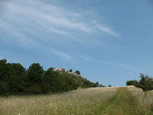
The is a 696.2 m above sea level. NHN high mountain in Hegau near Lake Constance . The Hohentwiel fortress ruins are located on the mountain . He is the local mountain singing and consists mainly of a phonolite -Schlotpfropfen. A phase of active volcanism began 15 million years ago, when Hohentwiel was a volcano. In a second, about eight million years commencing Vulkanismusphase could Magma not penetrate to the surface, forming the characteristic spring summit , which in the cold periods of the Quaternary by erosion of the glacier was exposed. The main rocks that make up the mountain are phonolite and tufa . In terms of vegetation, dry grass and forest predominate. In the rocks and walls of the ruin, for example, the rare Italian beautiful cricket lives .
People have been settling on the slopes of the Hohentwiel for 9,000 years. There are traces of the Neolithic , Rössen culture , the La Hoguette group and the Celts . A first fortification of the mountain around the year 915 is proven. The medieval castle was constantly expanded. At the beginning of the 16th century it passed into the possession of the Württemberg people , who expanded it into a state fortress. During the Thirty Years War the fortress was besieged five times without success. It was razed under Napoleon and soon afterwards developed into a tourist attraction. In 2008, 86,000 people visited the ruin.
A specialty is the highest wine-growing area in Germany at an altitude of 562 m above sea level. NHN : There are two wineries on the south side of the mountain. The northern part of the Hohentwiel has been tunnelled for the federal motorway 81 for a length of over 800 meters since 1988 .
Origin of name
The castle was first mentioned in the St. Gallen monastery chronicle of Ekkehard IV (around 980 to 1060) as castellum tuiel, which was besieged in 915. Since the transition from the late Middle Ages to the early modern period , the name Hohentwiel was used alongside Tuiel or Twiel . In this current form, the name is first documented in 1521.
Twiel - although a local name that is not uncommon in the Alemannic-speaking region - was no longer understood early on. The humanist Melchior Goldast wanted to derive the Hegau castle name from the Latin duellum 'place where there is fighting', which was rejected by Ernst Förstemann in his old German name book of 1859; instead he argued for a Celtic origin. Hermann Jellinghaus , who revised Förstemann's name book, questioned Förstemann's derivation in 1916, saying that it was “hardly Celtic”, that the name was “repeated several times in Switzerland”, but he was unable to attempt to explain it himself. Because of the initials, one has recently assumed an Alemannic origin. The word could go back to an Indo-European root tu- meaning 'swell'. This assumption is not certain.
Location and surroundings

The Hohentwiel is located in the Hegau volcanic region in the south of Baden-Württemberg . It belongs to the administrative region of Freiburg and the administrative district of Constance . The mountain rises north-west of Singen , on the boundary of which it is largely located. The Radolfzeller Aach runs at the foot of the eastern slope . To the south-east, ten kilometers away, is Lake Constance and to the west, three kilometers away, Hilzingen , the second subdivision.
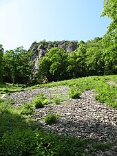
The head of the source of the Hohentwiel falls steeply on all sides and is completely forested . The foot of the mountain is formed by flatter slopes to the west, in the east the mountain rises directly and steeply around 260 meters from the Aachtal. In the north and northwest, the equally striking volcanic remains of Hohenkrähen , Mägdeberg and Hohenstoffeln tower up at a distance of four, five and six kilometers .
geology

From a geological point of view, the Hohentwiel is part of a unit that includes the Hegau and western Lake Constance. The different layers of the environment were created by sedimentation . With the formation of the Alps, volcanic activity began in the region. A remnant of it is the original Hohentwiel , a large chimney, filled with tufa . On its eastern edge, the phonolite rises up as further volcanic evidence.
Sedimentation since the Jurassic
200 million years ago, in the Jurassic , the edges of what would later become Central Europe were covered by a shelf sea that represented the edge of the ancient Tethys ocean . The layers of the southern German Jura were deposited through sedimentation . With the beginning of the unfolding of the Alps around 65 million years ago, in the early Palaeogene , the land rose more and more out of the water. The reason for this was the collision of the drifting continents Africa and Europe . To compensate for the uplift movements, the area between the newly unfolded Alps and the Swabian Alb sank , and with it the Hegau. At the same time, erosive processes began, which removed the dry surface. This material was deposited in the still flooded depression and formed a molasse basin on the sea floor in the form of so-called sea molasses . In the area of the river mouths from higher, dry areas, the material deposited as freshwater molasses. This created a 5000 meter thick molasse cover.
Volcanism in the Miocene
The unfolding of the Alps and the uplift of the Swabian Alb resulted in tensions and fractures in the depths in the Hegau area . After the water retreated , intraplate volcanism began in the Miocene around 15 million years ago . This is not tied to plate boundaries (continental boundaries ) as in tectonic volcanism , but occurs within a continental plate. In Hegau, volcanism can be traced back to a crossing of the fault zone running from north-west to south-east , the Bonndorfer Graben and a north-south running break from Höwenegg to Riedheim . There were active volcanoes in Hegau for six to seven million years. The time span can be divided into two sections. In the first three million years, the eruptions reached the surface of the earth. One of the volcanoes was the great-Hohentwiel , which over time by outbreaks a Tuff - Kegelberg was deposited. The mountain towered over its surroundings by 100 to 200 meters. In the course of time, the thickness of the ceiling tuffs was reduced again due to the lack of eruptions caused by erosion . Around eight million years ago, in the Tortonium , the second phase of volcanic activity took place. However, the rising magma no longer reached the surface, but solidified in its ascent paths through the molasses . This was probably caused by a different composition of the magma, a higher silica content made the mass tougher. This is how the chimney plug was created, which at that time was stuck under the 100 meter thick tuff cover.
Quaternary cold ages
The last strongly formative section in the Quaternary was the four cold ages ( Günz , Mindel , Riss and Würm ). The alpine glaciers scraped the landscape further and further, among other things the tuff cover over the Hohentwiel Schlotpfropfen was removed. In the last glacial period, the Würm glacial period 20,000 years ago, the Rhine Glacier penetrated north again. The Bodensee foreland glacier, part of the Rhine glacier, carried away the molasses and tuff layers around the Hohentwiel plug so that the plug came to the surface. Today the tuff has disappeared on the north and east sides and the plug rises 100 meters freely. Tuff is only present in the west, since here the plug neutralized the effect of the ice masses in their direction of advance. Since the ice thickness was no longer so great in the Würm Ice Age, the tip of the Hohentwiel probably protruded from the ice when the glacier last penetrated.
Stratification and rocks
600 meters below the surface of the earth in the area of the Hohentwiel lies the south-east sloping layer of the Brown Jura , on top of which the parallel White Jura . 100 meters above are the layers of kimmeridgium and tithonium . These layers, each 150 meters thick, are covered by the two-part Lower Freshwater Molasse. On the one hand, there is the 150-meter-thick layer consisting of erosion material from Jurassic rocks and, on the other hand, the basin facies of the lower freshwater molasse lying above , which is 70 meters thick. This is followed by the thin layer of brackish water molasses and above it the upper sea water molasses. In the east it is followed by the younger Juranagelfluh of the Upper Freshwater Molasse, on which a layer of phonolite rubble is deposited. In the west the tufa forms a thick layer. It is bounded further west by Glimmersanden and Jura Nagelfluh of the Upper Freshwater Molasse . In the far west of the mountain, these are covered by moraine material .
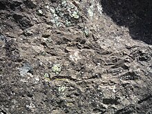
The distinctive cryptodome consists of phonolite , a rock that gets its name from the bright sound it makes when you strike it. The main components of the Hohentwiel phonolite are nepheline , nosean , leucite , sanidin and augite . The latter includes zircon , apatite and titanite . The silica content of the phonolite is between 50 and 55 percent. The uranium content is 350 grams per ton.
The ceiling tuffs form both the material in the chimney of the Ur-Hohentwiel and its ejection embankments in the vicinity. There are mainly concrete-like, gray ceiling tuff. It is seldom loose and brownish-reddish. Overall, no stratifications can be seen in the roof tufts . The silica content of the ejected lava was probably around 35 percent. Contents materials of the tuffs are volcanic crystals , lapilli and volcanic bombs . These "ejections" are 20 percent granites , syenites and diorites from the basement , 15 percent limestones from the White Jura, mainly mass limestone and Lias - and Dogger - clay stones .
The minerals in the lapilli, which can be up to four centimeters in diameter, mainly contain biotite , hornblende , montmorillonite , calcite , magnetite and pyroxene . This composition is identical to that of the surrounding tuff rock. A specialty of the Hohentwiel tuff are opal bulbs.
climate

The climatic zone in which the Hohentwiel lies is, according to the Köppen classification, "humid with warm summers" ( Cfb ) . The mountain lies in the global westerly wind zone in the slipstream of the Vosges , Black Forest and Jura . Precipitation is reduced by falling at the barriers. Summer thunderstorms make June and July the wettest months. Foehn weather conditions, which can temporarily increase the air temperature, also have an influence . The mesoclimate of Lake Constance also influences the climate at Hohentwiel. In winter, the lake prevents low temperatures as a heat store. The mass of water often leads to fog formation in autumn and winter , which prevents strong nocturnal radiation .
Since December 27, 1998, the private weather service Meteomedia has maintained a weather station on the church tower of the fortress ruins, which measures temperature and wind speed . The German Weather Service has a part-time weather station on the northern reaches of the Hohentwiel. On the grounds of blackness Court be rainfall , temperature, humidity and geothermal measured. According to Meteomedia, Hohentwiel was the second sunniest place in Germany after Scheidegg in 2007 with 2142 hours of sunshine. In 2008, 2057 hours were counted, which meant fourth place. The hurricane Lothar had his Europe highest measured wind speed 272 km / h on the Hohentwiel. However, the accuracy of this measurement is doubted.
nature
The biggest change in the appearance of the mountain was in 1890 when 12,000 trees were planted for reforestation. The mountain had been relatively unforested since the Middle Ages. In 1923, 20 hectares of forest in the steep area were protected as a spell forest , since after the First World War there was more wood theft. In 1941 the first nature reserve with an area of 108 hectares was designated on Hohentwiel; In 2004 it was expanded to 138 hectares. The nature reserve covers the entire mountain between Singen and Twielfeld and 19 hectares of forest. In the east, south and west it is framed by the 63 hectare landscape protection area with ruins, state domain and green areas at the foot of the Hohentwiel, also established in 2004 . The areas are also part of Natura 2000 , a protection project of the European Union .
See also → Hohentwiel (nature reserve)
See also → Hohentwiel / Hohenkrähen ( bird sanctuary )
The so-called Hohentwiel Volcano Path leads around the Hohentwiel . The three-kilometer-long nature trail circles the Hohentwiel approximately on the 600-meter contour line . On the basis of twelve stations with display boards , information on flora and fauna is mainly given, but geological and viticulture-related content is also conveyed.
vegetation
Rare types of plants thrive in various places on the Hohentwiel. On the southern side there are more Mediterranean species and on the northern side more Scandinavian species. Larger parts consist of forests and dry grass .
On the southern and western slopes, the soil is dry and stony and forms the basis for the dry grass. The steep slopes are particularly exposed to the sun's rays, so that the plants growing here have to develop special defense strategies. The common pasque flower, for example, protects itself with thick hair growth. Above the Twielfeld vineyards, the tufa is barely covered with humus . Gold aster , broad-leaved thyme , blue-green bedstraw , dyer's chamomile , glossy timothy grass and blue lettuce grow on the bare, very dry rocks . A special role of hyssop one. It is thought to have been released from the castle herb gardens and is the most important occurrence of its kind in Germany. Other plants are bouquet-bloomed usury flower , peach-leaved bellflower , round-leaved bellflower , sun rose , common thistle , carrot and bedstraw . Also steppe plants such as Veronica spicata and grove sage are in the lawn. On the barren, weathered tuff, plants such as vetch , sweet tragacanth , red vetch and white sweet clover have an advantage, as they can absorb nitrogen directly from the air. Grazing with sheep and goats can prevent fringed gentians and silver thistles from being displaced by overgrown, shady grasses. In the spring grows in the pastures, the Cowslip . Ball thistles , black nettles and round-leaved cranesbills grow in the vineyards exposed to the southwest . Blackthorn , rose species such as the vine rose , privet and common hazel are mainly found on bushes .
On the east and south-east side, the Olgaberg , semi- arid grasslands are at home. Meadow sage , Carthusian carnation , broad-leaved thyme and pigeon scabiosa grow here . The hawthorn occurs as a shrub .
The cooler, wetter locations on the north side are mostly overgrown with forest. These conditions are favored by plants such as forest goat's beard , golden buttercup , male orchid or creeping chamois . Wild garlic , hollow larkspur and yellow anemone grow on the shady phonolite debris heaps . The nodding thistle thrives on the sheep pastures .
White stonecrop , mountain leek , penton , roof houseleek and mountain stone herb grow on the ledges of the phonolite plug , as well as wall , Nordic and Swabian striped ferns .
The transition from the slope to the steep rock is overgrown with low oaks , rock pears and blue-red stone seeds .
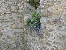
Numerous specialists grow in the unplastered wall joints of the castle ruins, sometimes more often than on the natural rock. These include low hawkweed , mountain stone herb , humpback stonecrop , blue lettuce, panicle saxifrage, and three-leaved valerian .
There are two different forest compositions around the phonolite cone. On the one hand there are Norway maples and summer linden trees , on the other hand ash , elm and maple . The first type of forest grows increasingly on the southern slopes and forms a steppe heather forest there together with field maple , pedunculate oak and hornbeam .
The summer lime tree also thrives in the forests on the north side, but there in combination with sycamore maple , ash and sycamore elm .
Wildlife
The dry grasslands are home to various species of animals. There, the butterflies live Adonis Blue , Common Blue , chess , dovetail and Blauflüglige and oedipoda germanica , the smooth snake and the beetles Grauflügliger Erdbock , Matter pill tomes and the dark blue ground beetles .
In the rocks and the mountain of the breed hiking and the Kestrel , the Raven and the red-backed shrike . The Italian beautiful hoppers and wall lizards live in the ruins .
The blue-winged wasteland insect and the brown-feeling fast-runner live between the vines of the vineyards . For the first time in Germany, the bark sac spider genus Phrurolithus could be detected.
Ash felling and falling rocks 2019
Initially, around 700 ash trees had to be felled on the slopes of the Hohentwiel at the beginning of 2019. These were infested with the false white stem cup and threatened the visitors with breaking branches or falling trees, which is why they had to be felled for reasons of traffic safety . 60–70% of the felled trees are left on site as dead wood , and extensive reforestation has been avoided. At the end of April 2019, a rockfall in the area of the fortress ruins resulted in a permanent blockage for visitors. Therefore, only the Karlsbastion was accessible until July 2020. First of all, loose pieces of rock were cleared away, the further safety measures could not yet be assessed, as these had to be put out to tender, for example. In November 2019, a scree fence was installed on the western side of the slope in the direction of Hilzingen, but it was damaged only a short time later by a new rockfall with around a ton of rock. It was therefore planned to attach a 75 square meter wire mesh to the slope.
Settlement
At the Hohentwiel are for the time around 7500 BC. Chr. First identified human settlement traces. Neolithic settlements were found during the construction of the Hohentwiel tunnel . East of the Hohentwiel (Offwiese) traces of the Rössen culture (4500 BC) were found. During the expansion of the Hegau-Bodensee-Klinikum (Torkelweg) in Singen in 1998, objects belonging to the La Hoguette group (6th millennium BC) were discovered. There was a Celtic settlement in the same place in the Bronze Age .
Castle and fortress

→ Main article: Hohentwiel Fortress
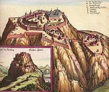
With a size of nine hectares, the former fortress is one of the largest castle ruins in Germany. It is divided into the Lower Fortress on the western slope and the Upper Fortress on the summit of Hohentwiel. Numerous buildings and defense structures have been preserved. The tower of the church can be climbed. Festivals have been held on Hohentwiel since 1969. Today it takes place under the name Hohentwiel Festival and well-known musicians have their performances every year.
middle Ages
The history of the Hohentwiel is shaped by the Twiel Castle and the Hohentwiel Fortress . It begins around 915 when a fortification on the Hohentwiel was besieged. At that time Burchard II was Lord of Twiel. It is not known what type of attachment it was; an earth-wood construction is assumed. It is also unclear whether she was already on the summit. 970 began Burchard III. and his wife Hadwig setting up a monastery on the Twiel . After Burchard's death, his widow continued to live on Twiel. In the 11th century the Twiel came into the hands of the Zähringer and in the 12th century the Lords of Singen took it over . The next owners were the masters of blades in the 13th century . The Twiel came into Klingenberg possession at the beginning of the 14th century. He was besieged in a feud between the Klingenbergers and the Werdenbergers in 1464, without any major fights being documented.
Modern times
In 1521 Duke Ulrich von Württemberg acquired the right to use the Hohentwiel and began to develop it into a fortress . The peasant wars broke out during the first expansion period . Ulrich supported the rebels because he was in opposition to the Habsburgs . There was no fighting on the Hohentwiel. In 1538 the Hohentwiel came to the Württemberg people for 12,000 guilders . During the Thirty Years War the Hohentwiel was besieged five times without success in 1635, 1639, 1640, 1641 and 1644. The Zavelstein pastor Johann Ebermaier (1599–1666) offers a particularly splendid depiction of the besieged Hohentwiel in a booklet designed as a New Year's greeting for the first year of peace in 1649. It is dedicated to Konrad Widerhold as a symbolic figure of Wuerttemberg's resilience and bears the strange heading Protection of Zion Castle but honors and eternal memory as well as congratulations on a new year rich in joy and joy: a Turkish army is besieging the Hohentwiel. The depiction leaves no doubt: the "infidels" are fighting against Zion Castle. The army of the Catholic contingents became the infidel Turks. But the evangelical occupation succeeds in defending their castle Zion. In the years 1653, 1700 and 1735 the fortress was further expanded, which was meanwhile used as the Württemberg state prison. A well-known prisoner was Johann Jacob Moser from 1759 to 1764 . In 1799 the fortress was taken by the French and razed in 1801 . After 1804 repairs were carried out again and again because the ruin was now attracting tourists. During the First and Second World Wars , air guards were stationed at the castle. At the end of the Second World War, the French shot at the fortress with tanks and caused damage to the structure. Until January 1, 1969, the Hohentwiel belonged to Tuttlingen as a former Württemberg exclave in Baden , only then did it come to Singen. However, the fortress remained with the state of Baden-Württemberg. From 1974 to 2009, 4.76 million euros were invested in securing the ruins.
Viticulture
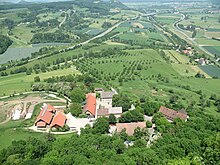
There are two vineyards on the slopes of the Hohentwiel. The Olgaberg , operated by the Meersburg State Winery, is exposed to the southeast . The south-west facing Elisabethenberg is owned by the Vollmayer winery. Both vineyards are the highest in Germany, with Olgaberg up to 530 meters and Elisabethenberg up to 562 meters. The advantages of the location on the Hohentwiel are the nutrient-rich and well-warming volcanic weathered soils. After the turn of the millennium, the two vineyards began to be re-terraced. Small terraces are created that can be better managed, and they also optimize solar radiation.
Viticulture on the Hohentwiel has been documented since 1538. It is believed, however, that the monks were already growing wine for their own use in 970. In the 16th and 17th centuries, wine was not just a drink, but also part of the soldiers' pay. Visitors to the castle usually carried stones up the mountain as building material. In return, they received wine and were allowed to register in the guest book. There are also references to the wine. After the castle was razed, the vineyards continued to be cultivated. In 1822, all cultivation areas were leased for the first time and reduced to the best locations. Bad harvests at the beginning of the 20th century led to the cessation of viticulture in 1912.
In 1928 Robert Vollmayer sen. with the replanting of the vineyards, in 1930 the first wine could be harvested. In 1934 he had to return the land on the Olgaberg to the lessor. But because he had leased another five hectare area on the Elisabethenberg, viticulture could continue. In 1948 the winery went to Robert Vollmayer jun. over, which increased the acreage to 6.3 hectares. Between 1963 and 1968 the business was expanded to 15 hectares, the size of which the winery still has today. Cultivated varieties are Müller-Thurgau , Bacchus , Pinot Gris , Pinot Blanc , Riesling , Traminer , Kerner , Chardonnay , Pinot Noir and Dornfelder .
In 1949 the Olgaberg passed to Walter Fahr, owner of the machine factory Fahr in Gottmadingen . With the administrative reform in 1969, the vineyard came into the possession of the Meersburg State Winery. In 1974 the acreage was 7.5 hectares. Müller-Thurgau, Weißer Burgunder, Blauer Spätburgunder, Riesling and Cabernet Sauvignon are grown there.
Agriculture
Agriculture is practiced on the flat foothills in the west and north, the areas are used as pasture, meadow or field. The history of agriculture goes back to the 16th century. In 1593 the Bergmaierhof was built as a domain . It is the predecessor of today's domain . Today there are two agricultural goods on the foothills: the state-owned Hohentwiel domain and the Schwärzehof . The domain operates sheep breeding with around 650 sheep and 50 goats on the steep meadows around the Hohentwiel. The areas are cultivated extensively , without artificial pesticides and feed additives and with only six sheep per hectare of pasture. At the same time, this type of grazing is a form of landscape management that shapes the appearance of the Hohentwiel on the pasture areas. The domain also looks after around 800 fruit trees.
Hohentwiel tunnel
The federal highway 81 leads with the Hohentwiel tunnel to the northwest under the foothills of the Hohentwiel and the Staufen . The first plans for a tunnel under the Hohentwiel were made around 1975. In 1976 and 1979 test bores took place. Construction began in 1985 and was completed at the end of June 1988 after three and a half years of construction. Since then, the motorway has run under the Hohentwiel in two two-lane tubes. The tube to the north is 785 meters long and that to the south is 833 meters. The construction costs amounted to 65 million DM . The tunnel variant was preferred to an above-ground route in order to keep the landscape relatively natural. In 2008 and 2009, the tunnel was adapted to the safety standards for 4.2 million euros.
Hiking trails
In addition to some hiking trails signposted by the city of Singen, the “ Hegau-Panorama-Weg ” and the “ Schwarzwald-Querweg Freiburg – Bodensee ” lead across the Hohentwiel .
literature
- Casimir Bumiller: Hohentwiel: The story of a castle between everyday fortress and great politics . 2nd Edition. Stadler, Konstanz 1997, ISBN 3-7977-0370-8
- Roland Kessinger (ed.), Klaus-Michael Peter (ed.): Hohentwiel book: Emperors, dukes, knights, robbers, revolutionaries, jazz legends (= Hegau library , volume 115). MarkOrPlan, Singen (Hohentwiel) / Bonn 2002, ISBN 3-933356-17-2
- 3rd edition 2009, ISBN 978-3-933356-17-8
- Josef Weinberg: The commandant from Hohen-Twiel ; Kurt Arnold Verlag, Stuttgart 1938 (historical novel).
- Roland Kessinger, Klaus-Michael Peter (ed.): The Hohentwiel - The mountain in the focus of the powers of Europe . 1st edition. MarkOrPlan, Singen (Hohentwiel) / Bonn 2015, ISBN 978-3-933356-80-2 .
Web links
swell
literature
- Roland Kessinger (Ed.), Klaus-Michael Peter (Ed.): 1. Appendix 2004/05 to the Hohentwiel Book . MarkOrPlan, Singen (Hohentwiel) / Bonn 2004, ISBN 3-933356-27-X
- Roland Kessinger (Ed.), Klaus-Michael Peter (Ed.): New Hohentwiel Chronicle (2nd appendix 2009/10 to the Hohentwiel book). MarkOrPlan, Singen (Hohentwiel) 2009, ISBN 978-3-933356-55-0
- Albert Schreiner : Hegau and western Lake Constance . In: Peter Rothe: Geological Guide Collection Volume 62 . 3rd corrected edition. Borntraeger, Berlin / Stuttgart 2008, ISBN 978-3-443-15083-9
- Ottmar Schönhuth : History of Hohentwiel, the unconquered fortress in the Thirty Years War. A contribution to the history of the same from documented sources . Freiburg im Breisgau 1836 ( e-copy ).
- Hans-Dieter Kuhn: The tombs on the Hohentwielfriedhof . In: Yearbook 71/2014 Hegau-Geschichtsverein eV , Singen (Hohentwiel), pages 93-108. ISBN 978-3-933356-79-6
Individual evidence
- ↑ Map services of the Federal Agency for Nature Conservation ( information )
- ^ Roland Kessinger: Swabian ducal residence. The early Twiel . In: Hohentwiel Buch, p. 19.
- ^ Ernst Förstemann: Old German name book, 2nd volume: Place names. Nordhausen 1959, col. 1421.
- ^ Ernst Förstemann: Old German name book. Part 2: Place Names, Vol. 2. 3., completely revised [and] expanded edition, ed. by Hermann Jellinghaus. Hanstein, Bonn 1916, column 1016.
- ↑ Casimir Bumiller: Hohentwiel: The story of a castle between everyday fortress and great politics . 2nd Edition. Stadler, Konstanz 1997, p. 16 f.
- ^ Albert Schreiner: Hegau and western Lake Constance . (P. 20ff).
- ^ A b Dirk Peters: From the original Hohentwiel to the Klingstein stopper . In: Hohentwiel book . (P. 10ff).
- ^ Albert Schreiner: Hegau and western Lake Constance . (Illustration 1).
- ^ Albert Schreiner: Hegau and western Lake Constance . (Figure 11).
- ^ Albert Schreiner: Hegau and western Lake Constance . (P. 26).
- ^ Albert Schreiner: Hegau and western Lake Constance . (P. 20ff).
- ↑ Torsten Baus, David Funk: Project study Bodensee ( page no longer available , search in web archives ) Info: The link was automatically marked as defective. Please check the link according to the instructions and then remove this notice. . 2002. Retrieved June 15, 2009.
- ↑ Stuttgarter Zeitung: Weather balance for the country - 2007 turned out to be much too warm ( memento of the original from November 2, 2008 in the Internet Archive ) Info: The archive link was inserted automatically and not yet checked. Please check the original and archive link according to the instructions and then remove this notice. . 2007. Retrieved April 27, 2009.
- ↑ Holger Dambeck: Weather balance 2008 - Where Germany shivered and sweated the most . 2009. Retrieved April 27, 2009.
- ↑ Martin Hubrig: Numerous interesting links + comments on Lothar . 2004. Retrieved May 30, 2009.
- ↑ New Hohentwiel Chronicle . (P. C32f).
- ↑ a b c d District Office for Nature Conservation and Landscape Management Freiburg: Vulkanpfad Hohentwiel . 2000.
- ^ A b Heinrich Werner: Flora am Hohentwiel . In: Hohentwiel book . (P. 15ff).
- ^ A b Elmar Zohren, Peter Lutz: Naturkundliches Paradies Hohentwiel . In: New Hohentwiel Chronicle . (P. C7ff).
- ↑ Torsten Lucht: Hohentwiel: clearing of more than 700 ash trees. In: Südkurier .com , November 23, 2018 accessed on July 11 of 2019.
- ↑ Susanne Gehrmann-Röhm: On the Hohentwiel 700 trees fall victim to the ash dieback. In: Südkurier .de , January 16, 2019, accessed on July 11, 2019.
- ↑ Susanne Gehrmann-Röhm: After the felling action, it looks blatant on Hohentwiel. In: Südkurier .de , March 14, 2019, accessed on July 11, 2019.
- ↑ Laura Marinovic: From July 11th, the Hohentwiel will be accessible again. But why is the mountain called that? In: Südkurier .com , July 9th 2020 accessed on 16 July 2020th
- ↑ Isabelle Arndt: Hohentwiel rocks should be secured with steel. In: Südkurier .de , June 17, 2019, accessed on July 11, 2019.
- ↑ Daniel Schottmüller: Not again: The next rockfall shakes the Hohentwiel. In: Südkurier .de , November 13, 2019, accessed on November 14, 2019.
- ↑ New Hohentwiel Chronicle . (P. C16).
- ↑ Peter Rückert: The Hohentwiel as "Castle Zion". A praise for the end of the Thirty Years War. In: Landesarchiv Baden-Württemberg (Hrsg.): Archive news . No. 57 , September 2018, p. 26-27 .
- ↑ Hohentwiel is being refurbished . In: Südkurier of May 29, 2009.
- ↑ Helmut Häusermann, Beate Vollmayer: Viticulture on Hohentwiel . In: Hohentwiel book . (P. 295ff).
- ^ Hubertus Both: The sheep farm on the Hohentwiel . In: Hohentwiel book . (P. 300ff).
- ↑ Klaus-Michael Peter: The Hohentwiel tunnel a success for environmental protection . In: Hohentwiel book . (P. 304f).
- ↑ Freiburg Regional Council: Road construction report 2008 ( Memento of the original from May 6, 2014 in the Internet Archive ) Info: The archive link was automatically inserted and not yet checked. Please check the original and archive link according to the instructions and then remove this notice. (PDF; 2.9 MB), accessed June 15, 2009.


