
District of Leonberg
| coat of arms | Germany map | |
|---|---|---|

|
Coordinates: 48 ° 50 ' N , 9 ° 0' E |
|
| Basic data (as of 1972) | ||
| Existing period: | 1938-1972 | |
| State : | Baden-Württemberg | |
| Administrative region : | North Württemberg | |
| Administrative headquarters : | Leonberg | |
| Area : | 290 km 2 | |
| Residents: | 132,408 (May 27, 1970) | |
| Population density : | 457 inhabitants per km 2 | |
| License plate : | LEO | |
| Circle key : | 08 1 40 | |
| Circle structure: | 27 municipalities | |
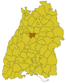
| Location of the district of Leonberg in Baden-Württemberg | ||
  |
||

The district of Leonberg was a district in Baden-Württemberg , which was dissolved in the course of the district reform on January 1, 1973 .
geography
location
The district of Leonberg was in the middle of Baden-Württemberg .
Geographically, he had a share in the eastern foothills of the Black Forest and the Strohgäu .
Neighboring areas
Its neighboring districts were 1972 starting in clockwise direction in the north Vaihingen , Ludwigsburg , city district Stuttgart , Böblingen , Calw and Pforzheim .
history
Already before 1800 the area of the district of Leonberg belonged mainly to Württemberg and to the imperial city of Weil der Stadt. That is why there was the Oberamt Leonberg even before 1800 . From 1807 the Oberamt Leonberg was enlarged. From 1810 it belonged to the Landvogtei Rothenberg and from 1818 to the Neckar District , which was dissolved in 1924. In 1934 the Oberamt Leonberg was renamed the District of Leonberg and in 1938 it received its last known expansion. In 1945 he came to the newly formed state of Württemberg-Baden , which was merged into the state of Baden-Württemberg in 1952 . From then on he belonged to the administrative region of North Württemberg, which included the Württemberg part of Württemberg-Baden.
With effect from January 1, 1973, the district of Leonberg was dissolved. The larger southern part of the district, including the district town of Leonberg itself, became part of the enlarged Böblingen district , the northern part was added to the enlarged Ludwigsburg district and some communities were added to the newly formed Enzkreis . Legal successor to the district of Leonberg was the district of Böblingen.
Population development
All population figures are census results.
|
|
politics
District Administrator
The district councils of the district Leonberg 1938-1972:
- 1938–1945: Otto Meditsch
- 1945–1948: Ludwig Schröter
- 1948–1954: Friedrich Michael Jetter
- 1954–1972: Wolfgang Ramsauer
The Oberamtmen of the former Oberamt Leonberg from 1796 to 1938 are shown in the article Oberamt Leonberg .
coat of arms
The coat of arms of the district of Leonberg showed an upright black lion in gold, holding an upright red key with a cross instead of the handle in its front paws. The coat of arms was adopted by the district council of the Leonberg district on September 28, 1956. An award by the Ministry of the Interior, which would actually have been necessary, does not seem to have taken place.
The lion is taken from the coat of arms of the district town of Leonberg. The key can be found in the coat of arms of Weil der Stadt ("Hinteramt"), and the cross symbolizes the so-called "Vorderamt" with Korntal.
The mosaic coat of arms by the sculptor Fritz Melis , which was attached to the then district office and later Leonberg town hall, found a new place on the garage deck of the new town hall building in 2017.
Economy and Infrastructure
traffic
The federal highways 8 and 81 , which meet at Kreuz Leonberg, run through the former district area . There are also federal highways 10 , 35 and 295 and several state and district roads .
Communities
From 1938 onwards, initially 27 communities belonged to the district of Leonberg, including 3 towns (Leonberg, Heimsheim and Weil der Stadt). 1958 Gerlingen and Korntal (today Korntal-Münchingen ) were elevated to cities; Ditzingen followed in 1966.
On March 7, 1968, the state parliament of Baden-Württemberg set the course for a community reform . With the law to strengthen the administrative power of smaller municipalities , it was possible for smaller municipalities to voluntarily unite to form larger municipalities. The beginning in the district of Leonberg was made on July 1, 1971 by the community of Schöckingen, which was incorporated into the city of Ditzingen. In the period that followed, the number of communities steadily decreased until the district of Leonberg was finally dissolved on January 1, 1973.
The largest municipality in the district was the district town of Leonberg , which has been a major district town since October 1, 1963, the smallest municipality was Hausen an der Würm.
In the table, the municipalities of the district of Leonberg are before the municipal reform. The population figures refer to the census results in 1961 and 1970.
License Plate
On July 1, 1956, the district was assigned the distinctive sign LEO when the vehicle license plates were introduced that are still valid today . It was issued until December 31, 1972. It has been available again in the Böblingen district since February 25, 2013 .
Web links
- LEO mark . JPEG graphic, 500 × 299 px. On the website of the District Office Böblingen , accessed on March 19, 2013.
Individual evidence
- ↑ a b Federal Statistical Office (ed.): Historical municipality register for the Federal Republic of Germany. Name, border and key number changes in municipalities, counties and administrative districts from May 27, 1970 to December 31, 1982 . W. Kohlhammer, Stuttgart / Mainz 1983, ISBN 3-17-003263-1 , p. 452 .
- ↑ A reminder of politically turbulent times. Stuttgarter Zeitung, June 17, 2017.
.svg)
Basking | Backnang | Baden-Baden | Balingen | Biberach | Boeblingen | Bruchsal | Book | Bühl | Calw | Crailsheim | Donaueschingen | Ehingen | Emmendingen | Esslingen | Freiburg (city) | Freiburg (State) | Freudenstadt | Friedrichshafen | Göppingen | Hechingen | Heidelberg (city) | Heidelberg (Country) | Heidenheim | Heilbronn (city) | Heilbronn (Land) | Black Forest | Horb | Karlsruhe (city) | Karlsruhe (State) | Throat | Constance (city) | Constance (Country) | Künzelsau | Lahr | Leonberg | Loerrach | Ludwigsburg | Mannheim (city) | Mannheim (State) | Mergentheim | Mosbach | Muellheim | Münsingen | Neustadt | Nürtingen | Offenburg | Öhringen | Pforzheim (city) | Pforzheim (Country) | Rastatt | Ravensburg | Reutlingen | Rottweil | Säckingen | Saulgau | Schwäbisch Gmünd | Schwäbisch Hall | Sigmaringen | Sinsheim | Stockach | Stuttgart | Tauberbischofsheim | Tettnang | Tübingen | Tuttlingen | Überlingen | Ulm (city) | Ulm (State) | Vaihingen | Villingen | Villingen-Schwenningen | Waiblingen | Waldshut | Cheeks | Wolfach