Lahr district
| coat of arms | Germany map | |
|---|---|---|

|
Coordinates: 48 ° 20 ' N , 7 ° 50' E |
|
| Basic data (as of 1972) | ||
| Existing period: | 1938-1972 | |
| State : | Baden-Württemberg | |
| Administrative region : | South Baden | |
| Administrative headquarters : | Lahr | |
| Area : | 445 km 2 | |
| Residents: | 88,475 (May 27, 1970) | |
| Population density : | 199 inhabitants per km 2 | |
| License plate : | LR | |
| Circle key : | 08 3 37 | |
| Circle structure: | 42 municipalities | |
| Location of the district of Lahr in Baden-Württemberg | ||
The district of Lahr was a district in Baden-Württemberg , which was dissolved in the course of the district reform on January 1, 1973 .
geography
location
The district of Lahr was in the west of Baden-Württemberg .
Geographically, the Lahr district predominantly had a share in the Upper Rhine Plain and the Black Forest . The district town was roughly in the middle of the district.
Neighboring areas
Its neighboring districts were 1972 clockwise beginning in the north of Kehl , Offenburg , Wolfach and Emmendingen . In the west, the Rhine formed the natural border with France .
history
Before 1800, the area of the later district of Lahr belonged to different domains. In 1803 the area came to Baden , which initially formed several offices , including the offices or district offices Ettenheim, Lahr and Mahlberg, but in 1813 the Mahlberg district office was merged with Ettenheim. The district offices of Lahr and Ettenheim belonging to the regional commissioner district of Freiburg were merged in 1924. From this the district of Lahr emerged in 1939.
After the formation of the state of Baden-Württemberg in 1952, the district of Lahr belonged to the administrative district of South Baden . With effect from January 1, 1973, the Lahr district was dissolved. His communities were completely absorbed in the newly formed Ortenaukreis , which became the legal successor to the Lahr district.
Population development
All population figures are census results.
|
|
politics
District Administrator
The senior officials or district administrators of the district office or district of Lahr 1803–1972:
- 1803–1812: Wilhelm Carl Christian Bausch
- 1812–1820: Ludwig August Friedrich von Liebenstein
- 1820–1824: Eduard Wundt
- 1824–1842: Gottlieb Friedrich Lang
- 1842: Karl Ludwig Böhme
- 1843–1844: Wilhelm Bausch
- 1844–1847: Ignaz Fränzinger
- 1847–1849: Maximilian Waag
- 1849–1853: Carl von Neubronn
- 1853–1858: Karl Wielandt (senior magistrate)
- 1859–1864: Gottlieb Jonathan Winter
- 1864–1877: Peter Guerillot
- 1877–1882: Alexander Wallau
- 1882–1893: August Winther
- 1893–1895: Karl Deitenmann
- 1895–1897: Karl Weingärtner
- 1897–1902: Hans von Krafft-Ebing
- 1902–1908: Konrad Herrmann
- 1908–1914: Anton Josef Beck
- 1914–1924: Hermann Ludwig Pfeiffer
- 1924–1926: Georg Herrmann
- 1926–1929: Richard Hepp
- 1929–1935: Otto Schoch
- 1935–1945: Paul Strack
- 1945–1946: Wilhelm Lenssen
- 1946: Josef Astfäller (acting)
- 1946–1947: Wilderich Cuno
- 1947–1948: Pius Uhrig
- 1948–1955: Viktor Huber von Gleichenstein
- 1955–1972: Georg Wimmer
coat of arms
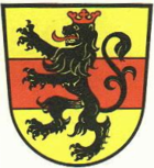
The coat of arms of the district of Lahr showed in gold a red crowned and red-tongued black lion with a red bar underneath. The coat of arms was awarded to the Lahr district on September 30, 1960 by the Baden-Württemberg Ministry of the Interior .
The red bar stands for the former county of Geroldseck , to which 6 communities belonged before 1803. The Mahlberger lion stands for the eponymous rule of the margraves of Baden-Baden, to which a large part of the district area also belonged.
Economy and Infrastructure
traffic
The federal motorway 5 Karlsruhe-Basel ran through the district area from north to south . Federal highway 3 also ran through the district.
Communities
From 1936 there were initially 42 municipalities in the Lahr district, including 3 towns.
On March 7, 1968, the state parliament of Baden-Württemberg set the course for a community reform . With the law to strengthen the administrative power of smaller municipalities , it was possible for smaller municipalities to voluntarily unite to form larger municipalities. The beginning in the Lahr district was made on July 1, 1971 by the municipality of Wallburg, which merged with the city of Ettenheim, and the municipality of Schönberg, which merged with the municipality of Seelbach. In the period that followed, the number of municipalities steadily decreased until the Lahr district was finally dissolved on January 1, 1973.
The largest municipality in the district was the large district town of Lahr / Black Forest , the smallest municipality was Wittelbach.
In the table, the municipalities of the Lahr district are before the municipal reform. All today's communities belong to the Ortenaukreis. The population figures refer to the census results in 1961 and 1970.
License Plate
On July 1, 1956, the district was assigned the distinguishing sign LR when the vehicle registration number that is still valid today was introduced . It was issued until December 31, 1972. It has been available in the Ortenau district since March 31, 2014.
Individual evidence
- ↑ a b Federal Statistical Office (ed.): Historical municipality register for the Federal Republic of Germany. Name, border and key number changes in municipalities, counties and administrative districts from May 27, 1970 to December 31, 1982 . W. Kohlhammer, Stuttgart / Mainz 1983, ISBN 3-17-003263-1 , p. 498 .


