
Meissenheim
| coat of arms | Germany map | |
|---|---|---|

|
Coordinates: 48 ° 25 ' N , 7 ° 46' E |
|
| Basic data | ||
| State : | Baden-Württemberg | |
| Administrative region : | Freiburg | |
| County : | Ortenau district | |
| Height : | 151 m above sea level NHN | |
| Area : | 21.33 km 2 | |
| Residents: | 4060 (December 31, 2018) | |
| Population density : | 190 inhabitants per km 2 | |
| Postal code : | 77974 | |
| Area code : | 07824 | |
| License plate : | OG, BH , KEL, LR, WOL | |
| Community key : | 08 3 17 075 | |
| Address of the municipal administration: |
Winkelstrasse 28 77974 Meißenheim |
|
| Website : | ||
| Mayor : | Alexander Schröder | |
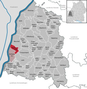
| Location of the community of Meißenheim in the Ortenau district | ||
  |
||

Meißenheim is a municipality in Baden-Württemberg and belongs to the Ortenau district .
geography
location
Meißenheim is located in the Upper Rhine Plain directly on the Rhine and thus on the German- French border, about 13 km from Lahr .
Neighboring communities
The municipality borders Neuried to the north, Friesenheim and the city of Lahr to the east, Schwanau to the south and the Alsatian municipality of Gerstheim to the west .
Community structure

The two villages of the same name belong to the municipality of Meißenheim with the formerly independent municipality of Kurzell. In the municipality part of Kurzell are the abandoned villages Hoschweier, Kenle, Merzweier, Mietershofen and Vastolfsweier. In the Meißenheim part of the municipality are the abandoned localities of Äußerer and Innerer Hilbertshof, which are now indicated by a field name .
history
Meißenheim was first mentioned in a document in 1267. Initially, the place belonged to the Lords of Geroldseck as a fief of the diocese of Strasbourg , and then passed to the Lords of Hattstadt in the 14th century . In 1464 the Strasbourg citizen Bernhard Wurmser bought the village. It remained in the possession of his family until 1805 and then came to the Grand Duchy of Baden as part of the mediatization due to the Reichsdeputationshauptschluss .
From 1939 Meißenheim belonged to the Lahr district , with which it merged in 1973 in the new Ortenau district. On January 1, 1972, the community of Kurzell was incorporated into Meißenheim.
Religions
Although a Strasbourg fiefdom, the Wurmser family introduced the Reformation in Meißenheim . Even today the place is predominantly evangelical . In addition to the two Protestant churches (one for each district) there is also a Roman Catholic community in Kurzell and a New Apostolic community in the main town .
politics
Administrative community
The municipality of Meißenheim forms an agreed administrative community with the municipality of Schwanau .
Municipal council

The local elections on May 25, 2014 with a turnout of 58.33% brought the following result:
|
A total of 14 seats
|
Local election 2014
% 40 30th 20th 10
0
35.7%
(+ 3.1 % p ) 30.9%
(-0.6 % p ) 25%
(-2.4 % p ) 8.5%
(-0.4 % p ) 2009
2014
|
There is a separate local council for Kurzell.
mayor
Alexander Schröder was elected to succeed Gerlinde Kleis in the second ballot in September 2009 and prevailed against Gerhard Bidermann in September 2017 with 89.9% of the votes.
coat of arms
Blazon : “A red ring in gold.” It is a spiral ring ; the coat of arms probably depicts the old village symbol.
Culture and sights
music
- Church choir, trombone choir, music association, men's choir, hunting horn players, fanfare parade, zither ensemble Zith-A5
Buildings


- Evangelical Church Meißenheim , baroque church from 1766 with Silbermann - organ . The sanctuary of the church was refurbished in 2003 by Christoph Manuel Beysser and Markus Artur Fuchs.
- Recently, St. Laurentius has a church in the classical style . Built from 1829 to 1830 by Hans Voss , the church has a baroque appearance thanks to the richly detailed work and a low tower roof - this aspect makes it an unusual church in the Weinbrenner style, which is actually known for its powerful, monumental effect . The church was used jointly by the Protestant and Catholic churches as a simultaneous church until 1962 .
Parks
Meissenheim:
- Riedhof with Christophorus Chapel, Stations of the Cross, Easter and Christmas dome, pond and biotope.
- Mühlbach promenade with relaxation pavilions, viewpoints and biotope.
- Baggersee with sandy beach and Schollenhütte with barbecue facilities
Economy and Infrastructure
traffic
Meißenheim was connected to the rail network by the Mittelbadische Eisenbahn ( Kehl - Seelbach (Schutter) ) until 1959 . The state road 75 crosses the district of Meißenheim.
education
The Friederike Brion School is a primary school in Meißenheim . In the district of Kurzell there is also a school for children with learning disabilities. There is a Protestant kindergarten in each of the two districts , in short one also run by the Roman Catholic parish.
Personalities
Sons and daughters of the church

- Franz Joseph Gießler (1854–1923), born in Kurzell, district court director and member of the Baden state parliament ( center )
- Ferdinand Kopf (1857–1943), born in Kurzell, lawyer, member of the state parliament
- Karl Fischer (1871–1931), politician ( DNVP ), member of the Landtag and Reichstag
- Karl Hoppe (1889–1963), politician ( SPD , KP ), member of the Saarland state parliament
- Werner Schwärzel (* 1948), motorcycle racer, world champion in the sidecar class in 1982.
- Ewald Meier , national coach in driving
Honorary citizen
- Oskar Bohnert (2003)
- Herbert Reith (2003)
- Adolf Hitler (date unknown, revoked in 2016)
Other personalities associated with the community
- Friederike Brion (1752–1813), Goethe's childhood sweetheart, was buried in Meißenheim.
literature
- Johannes Georg Schilher: Chronicon Meissenheimense . Heidelberg 1844 ( e-copy ).
- Albert Köbele : Meißenheim village family book , Lahr district in Baden, 1568–1969 . 2nd Edition. Grafenhausen: Köbele 1969 (= Badische Ortssippenbücher 1)
Web links
- Meissenheim
- Meißenheim: Local history & pictures
- Meissenheim and Kurzeller Church of St. Laurentius on an architecture website
Individual evidence
- ↑ State Statistical Office Baden-Württemberg - Population by nationality and gender on December 31, 2018 (CSV file) ( help on this ).
- ^ The state of Baden-Württemberg. Official description by district and municipality. Volume VI: Freiburg region Kohlhammer, Stuttgart 1982, ISBN 3-17-007174-2 . Pp. 416-417
- ^ Federal Statistical Office (ed.): Historical municipality directory for the Federal Republic of Germany. Name, border and key number changes in municipalities, counties and administrative districts from May 27, 1970 to December 31, 1982 . W. Kohlhammer, Stuttgart / Mainz 1983, ISBN 3-17-003263-1 , p. 498 .
- ^ Schröder is the new mayor of Meißenheim in the Badische Zeitung on September 27, 2009
- ↑ http://www.ekiba.de/html/content/meissenheim_prinzipalien779.html?t=7cf300dca5cd6fd3ef8cb5ac2a81522d&tto=f39d5b5c&&

Achern | Appenweier | Bad Peterstal-Griesbach | Berghaupten | Biberach | Durbach | Ettenheim | Fischerbach | Friesenheim | Gengenbach | Gutach (Black Forest Railway) | Haslach im Kinzigtal | Hausach | Hofstetten | Hohberg | Hornberg | Kappel-Grafenhausen | Kappelrodeck | Throat | Kippenheim | Lahr / Black Forest | Run | Lautenbach | Mahlberg | Meißenheim | Mühlenbach | Neuried | Nordrach | Oberharmersbach | Oberkirch | Oberwolfach | Offenburg | Ohlsbach | Oppenau | Ortenberg | Ottenhöfen in the Black Forest | Renchen | Rheinau | Ringsheim | Rust | Sasbach | Sasbachwalden | Schuttertal | Schutterwald | Schwanau | Seebach | Seelbach | Steinach | Willstätt | Wolfach | Zell am Harmersbach
Rheinau (municipality-free area)